Abstract
This paper introduces the Basic Ordnance Observation Management System, a prototype application supporting geovisual exploration and analysis of improvised explosive device (IED) incidents. Use of IEDs by terrorist cells has increased in geographic scale, frequency, and sophistication due to the relative cheap cost of acquiring the materials and the ease in keeping such weaponry covert. The Basic Ordnance Observational Management System is designed to facilitate spatiotemporal sensemaking of the IED incident dataset maintained by the National Counter Terrorism Center, Worldwide Incident Tracking System. The application expands upon existing geovisual analytics tools for understanding patterns, trends, and anomalies in IED activity through provision of a suite of capabilities that include: flexible spatial and temporal aggregates of the IED dataset; linked spatial, temporal, and attribute views of the incident information; temporal re-expression, particularly the generation of linear and composite sequences of the IED dataset; and temporal animation across IED activity, with ‘VCR’ controls and an interactive temporal legend to control the animation as well as visual benchmarks to assist with interpretation of the animation.
1. Introduction
Sensemaking describes the process of acquiring and synthesizing information relevant to a given problem, exploring this collection of information to extract insights into patterns, trends, and anomalies characterizing the problem, and presenting these key insights to make informed decisions about how best to respond to the problem (Pirolli & Card, Citation2005). The sensemaking process is particularly important in the context of intelligence analysis, as the information collected is often disparate in source, heterogeneous in format, voluminous in size, and poor in certainty. The field of visual analytics has been proposed as an area of research and development to investigate how the sensemaking process – particularly the exploration and analysis of large collections of information – can be supported through visual interfaces to computation methods (Thomas et al., Citation2005); the term geovisual analytics is used to describe the intersection between this research thrust and existing GIScience research (Andrienko et al., Citation2007).
Here, we introduce the Basic Ordnance Observational Management System (), a map-based prototype application developed at the Penn State GeoVISTA Center that leverages established geovisual exploration and analysis techniques to support sensemaking of improvised explosive device (IED) incidents against civilian targets. The proof-of-concept application is publicly available at: http://www.geovista.psu.edu/BOOMsys/. The paper continues with three additional sections. In the following section, we introduce the sensemaking context supported by the Basic Ordnance Observational Management System: Geovisual exploration and analysis of IED incidents. This section provides a logical argument regarding the need for the visual exploration and analysis of IED incidents. In the third section, we introduce the design influences and key functionality of the Basic Ordnance Observational Management System. This description contributes to geovisual analytics by providing an example of how existing and novel visual tools and technologies can be combined in support of spatiotemporal sensemaking. We offer concluding remarks and an outlook on future work in the fourth and final section.
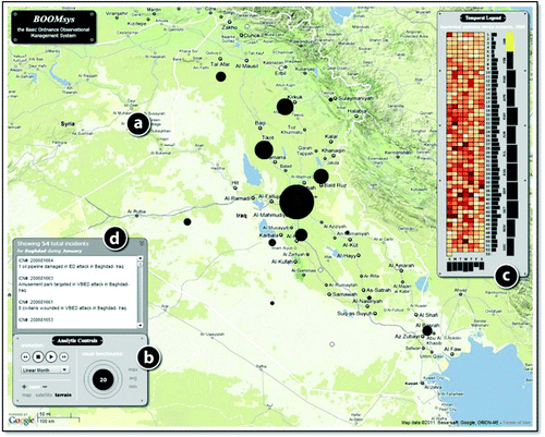
Figure 1. The Basic Ordnance Observational Management System: (http://www.geovista.psu.edu/BOOMsys/). (a) The central map view, showing a set of proportional symbols indicating the frequency of IED incidents for the selected time period; (b) the suite of spatiotemporal analytic controls, including functions for manipulating the map (flexible map browsing and basemap toggling), for controlling the animation (i.e., VCR controls), for changing the temporal binning, and for adding visual benchmarks to the display; (c) an interactive temporal legend based the reruns visualization; and (d) a records list providing metadata and links to each IED incident in the WITS database.
2. Background and problem context
The specific sensemaking context supported by the Basic Ordnance Observational Management System is geovisual exploration and analysis of IED incidents in space and time. Use of IEDs by terrorist cells has increased in geographic scale, frequency, and sophistication due to the relatively cheap cost of acquiring the materials (when compared to military-issued weaponry) and the ease in keeping such weaponry covert. IED attacks accounted for approximately 23,000 civilian and military casualties worldwide in 2009 (NCTC, Citation2010) and have become the most consistent and substantial threat to multi-national forces deployed in active operational areas (Castro, Citation2007). A recent report from the United States Government Accountability Office (2009) identified counter-IED shortcomings in several areas, including IED data dissemination, IED spatial analysis, and IED threat analysis. The Basic Ordnance Observational Management System prototype examines the potential for ameliorating these shortcomings through provision of geovisual analytics tools and techniques.
The Basic Ordnance Observational Management System plots a publicly available IED incident database maintained online by the National Counterterrorism Center (NCTC) World Wide Incident Tracking System (WITS) (http://www.nctc.gov/site/other/wits.html), aggregated by country and city. For each incident in the dataset, information is provided about the event type (e.g., armed attack, bombing, kidnapping), the weapon type (e.g., IED, firearm, rocket), the location (e.g., city, country, geocode anchor), the date and time the incident occurred, the number of victims wounded and killed, and an incident summary report. The IED dataset is cleaned and loaded into the application dynamically at run-time. For demonstrative purposes, the complete dataset has been constrained to only those incidents occurring in Iraq during 2006, producing a reduced subset of 2367 records.
The Basic Ordnance Observational Management System combines coordinated, multiple view visualization and high levels of user interaction to allow the analyst to produce a variety of unique representations of the WITS IED dataset, which in turn facilitates the generation and enrichment of insights (Kraak & MacEachren, Citation1999; MacEachren, Citation1994). The primary goal of the Basic Ordnance Observational Management System is to reveal previously unknown and actionable insights about IED incidents, which can be used to inform operational and policy decisions. In particular, an emphasis is placed on sensemaking in both space and time, a key research area within geovisual analytics (e.g., Andrienko & Andrienko, Citation2005). The Basic Ordnance Observational Management System was developed in ActionScript 3.0 using Flash CS4. The project is available as an open source code repository through the Penn State GeoVISTA Center (http://www.geovista.psu.edu/).
3. Interactive map design
Navigation of the Basic Ordnance Observational Management System was designed to follow Shneiderman's (Citation1996: 337) mantra of ‘Overview first, zoom and filter, then details on demand’. In keeping with this mantra, overview information graphics are first presented in both space and time. Analysts can interact with these overviews to identify patterns, trends, and anomalies of interest. Each incident record then can be examined in detail, assisting the analyst in generating a set of competing hypotheses about the identified pattern, trend, or anomaly. The Basic Ordnance Observational Management System includes four coordinated panels in order to support this structured, top-down navigation: (a) a central map view, (b) a suite of space-time analytic controls, (c) an interactive temporal legend, and (d) a records list; each is considered in the following feature description. shows the four coordinated panels of the Basic Ordnance Observational Management System upon entry to the application.
The central map view ( plots overview spatial aggregates of the IED dataset atop tiles from the Google Maps web mapping service using proportional symbols. The map view provides the cartographic interaction operators typical of a ‘slippy’ web mapping service (i.e., pan, zoom, overlay, retrieve) through the direct manipulation interface style (Roth, Citation2011). The analyst can manipulate the basemap in accordance with Google Maps mashup conventions, which include flexible map browsing (i.e., panning and zooming; Roth & Harrower, Citation2008) and toggling among multiple basemap depictions (e.g., overlay of a vector map, satellite image, shaded relief with land cover types). Selection of an individual proportional symbol plotted in the map view activates a popup window containing summary information (i.e., information retrieval), as well as updates the records list.
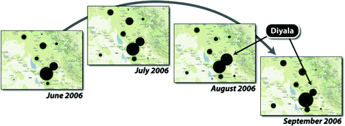
The analytic controls panel ( includes a suite of interfaces for manipulating the temporal sequencing of the IED dataset as well as an information graphic providing overview temporal aggregates for the entirety of 2006. The analyst is able to toggle among three linear sequences varying by the binning unit, or temporal interval used for the flexible aggregation: (1) linear aggregation by day, producing 365 bins; (2) linear aggregation by week, producing 53 bins due to a partial week at the end of 2006; and (3) linear aggregation by month, producing 12 bins. The analyst also can focus upon cyclical patterns by generating a composite sequence of average day by week, resulting in seven bins (Moellering, Citation1976). The central map only shows incidents occurring during a single interval of time (e.g., a single bin within the complete sequence). To understand trends over time, the analyst can animate the map across all bins using the provided ‘VCR’ controls (Harrower & Fabrikant, Citation2008). The temporal binning and cartographic animation functionality leverages the event animation code library described in Roth and Ross Citation(2009). Finally, the analyst also can add static visual benchmark rings () around the dynamic proportional symbols that depict the frequency in the minimum bin (i.e., the trough) and maximum bins (i.e., the peak), as well as the average frequency across all bins (Harrower, Citation2002). The use of visual benchmarks facilitates interpretation of spatiotemporal patterns by overcoming the problem of disappearance common to cartographic animation, or the problem of missing intricate or complex patterns due to constant display change, (Harrower, Citation2003).
Figure 2. Cartographic animation and visual benchmarks for space-time Analysis. Using cartographic animation and visual benchmarks in combination reveals that most places peak in September 2006, excepting Diyala, which peaks one month earlier instead (August 2006). Such an anomaly may provide important insight into the way in which IED attacks are planned, which ultimately can be leveraged to determine a course of action that is customized in both space and time.
To assist in the selection of an appropriate binning unit and sequencing method, an overview temporal graphic ( is provided similar to Weaver et al.'s (2007) reruns visualization. This temporal graphic shows the aggregated frequencies by day within the center of the graphic and aggregated frequencies by week (across the vertical axis) and month (across the horizontal axis) along the sides of the graphic. The temporal visualization also acts as a temporal legend for the animation, providing simultaneous overviews for each of the four provided binning sequences and highlighting the current time interval that is plotted to the map. As with the proportional symbols, interaction with the temporal graphic updates the records list; such interaction also advances the animation to the associated time interval, which in turn updates the map view.
The records list ( provides analysts with details about each IED incident, completing Shneiderman's (Citation1996: 337) mantra of ‘Overview first, zoom and filter, then details on demand’. The records list is populated once the analyst submits a spatial or temporal query (by selecting a proportional symbol or a bin in the temporal legend respectively). The analyst then can follow-up with the identified subset of records through the World Wide Incident Tracking System (WITS) website (http://www.nctc.gov/site/other/wits.html) to learn more about the individual incidents comprising the pattern, trend, or anomaly of interest.
4. Conclusion and outlook
The Basic Ordnance Observational Management System is a geovisual analytics prototype to support sensemaking of IED incidents through provision of geovisual analytics tools and techniques. It enables analysts to extract temporal and spatial patterns, trends, and anomalies in past IED activity for use in strategic decision making. Future work includes increasing the analytical capabilities of the prototype application as well as scaling the system to a larger geographic extent (i.e., beyond Iraq in order to investigate global patterns of IED attacks on civilians) and temporal extent (i.e., beyond a single year in order to investigate seasonal patterns). In particular, we want to expand the functionality available for filtering the map by additional attributes contained within the IED incident dataset, allowing for exploration and analysis of more nuanced patterns, trends, and anomalies. We also expect to develop use case scenarios and to perform user studies with domain experts in order to refine and extend the system to better support the sensemaking needs of the targeted end users.
Acknowledgement
We thank Dr Alan MacEachren of the Penn State GeoVISTA Center for input and feedback on the application. We also thank Ben Finch for input on the initial conceptual design of the application. This material is based upon work supported by the US Department of Homeland Security under Award #2009-ST-061-CI0001.
Related Research Data
References
- Andrienko , N. and Andrienko , G. 2005 . Exploratory analysis of spatial and temporal data: A systematic approach , New York , NY : Springer-Verlag .
- Andrienko , G. , Andrienko , N. , Jankowski , P. , Keim , D. , Kraak , M.-J. MacEachren , A. 2007 . Geovisual analytics for spatial decision support: Setting the research agenda . International Journal of Geographical Information Science , 21 ( 8 ) : 839 – 857 .
- Castro , R. 2007 . Improvised explosive device defeat , Washington , DC : Department of the Army .
- Harrower , M. 2003 . Tips for designing effective animated maps . Cartographic Perspectives , Winter (44) : 63 – 65 .
- Harrower , M. and Fabrikant , S. 2008 . “ The role of map animation in geographic visualization ” . In Geographic visualization: Concepts, tools, and applications , Edited by: Dodge , M. , McDerby , M. and Turner , M. 49 – 65 . West Sussex , , England : John Wiley & Sons .
- Harrower , M. A. 2002 . Visual benchmarks: Representing geographic change with map animation Geography, Penn State, University Park, PA
- Kraak , M.-J. and MacEachren , A. 1999 . Visualization for exploration of spatial data . International Journal of Geographical Information Science , 13 ( 4 ) : 285 – 287 .
- MacEachren , A. M. 1994 . “ Visualization in modern cartography: Setting the agenda ” . In Visualization in modern cartography , Edited by: MacEachren , A. M. and Taylor , D. R. F. 1 – 12 . Oxford , , England : Pergamon .
- Moellering , H. 1976 . The potential uses of a computer animated film in the analysis of geographical patterns of traffic crashes . Accident Analysis and Prevention , 8 : 215 – 227 .
- (NCTC), N. C. C . 2010 . “ 2009 Report on Terrorism ” . Washington , DC : Office of the Director of National Intelligence .
- Pirolli , P. and Card , S. 2005 . “ The sensemaking process and leverage points for analyst technology as identified through cognitive task analysis ” . Paper read at International Conference on Intelligence Analysis, at McLean, Va
- Roth , R. E. 2011 . “ Interacting with Maps: The science and practice of cartographic interaction ” . Geography, Pennsylvania State University, University Park
- Roth , R. E. and Harrower , M. 2008 . Addressing map interface usability: Learning from the Lakeshore Nature Preserve Interactive Map . Cartographic Perspectives , 60 ( Spring ) : 46 – 66 .
- Roth , R. E. and Ross , K. S. 2009 . Extending the Google Maps API for event animation mashups . Cartographic Perspectives , 64 : 21 – 40 .
- Shneiderman , B. 1996 . “ The eyes have it: A task by data type taxonomy for information visualization ” . Paper read at IEEE Conference on Visual Languages, at Boulder, CO
- Thomas , J. J. , Cook , K. A. , Bartoletti , A. , Card , S. , Carr , D. , Dill , J. and Earnshaw , R. 2005 . Illuminating the path: The research and development agenda for visual analytics , Los Alametos , CA : IEEE CS Press .
- Weaver , C. , Fyfe , D. , Robinson , A. , Holdsworth , D. , Peuquet , D. and MacEachren , A. M. 2007 . Visual exploration and analysis of historic hotel visits . Information Visualization , 6 : 89 – 103 .