Abstract
The inclusion of environmental care data in the decision-making process should be based on the results obtained after scientifically evaluating different environmental variables. Herein, a European landscape geographic model is presented. This landscape map would allow the environmental care variable ‘visual landscape’, along with other information related to vegetation, geology, soils, cultural variables, etc., to be integrated into the planning process.
The methodology used is not new since it has already been tested in Spain by the authors. Nevertheless, the model was adapted to cope with the much more extensive territory of the European Union. This meant dealing with computational difficulties, and a lack of information.
The result of this work is a raster map (100 m cell size) that evaluates landscape quality in Europe by dividing the area into seven visual quality classes. This is a practical tool for territorial development that will facilitate the environmental assessment of plans, such as infrastructure plans, within a strategic pan-European framework.
Introduction
The landscape, defined as ‘an area as perceived by people, whose character is the result of the action and interaction of natural and/or human factors’ (CitationCouncil of Europe, 2000), must be considered as an environmental resource in land planning processes at the national, regional and local level, and needs to be taken into account when designing strategies for sustainable development (CitationMeeus, 1995). Frontiers between countries within the European Union become diffuse in initiatives involving extensive territories, as is the case of the Trans-European Transport Network. At the territorial scale, landscape evaluation must take place within a supranational context, using natural rather than artificial boundaries. There is therefore growing interest in including landscape resources when drafting policies, and in management and planning processes (CitationTress, Tress, Decamps, & D'Hausteserre, 2001; CitationWascher, 2000) on the European scale, as specified in the European Landscape Convention (CitationCouncil of Europe, 2000). This states that there is a need to ‘consider the landscape dimension of international policies and programmes’, and dedicates Article 9 to ‘transfrontier landscapes’. Landscape maps based on consistent approaches and reliable information are important tools for assessment, protection, management, and planning (CitationMücher, Klijn, Wascher, & Schaminée, 2010).
Visual landscape assessment involves the evaluation of a number of physical, aesthetic, and psychological attributes (CitationCañas, Ayuga, & Ayuga, 2009). The landscape has physical reality independent of the observer, and a reality that depends on individual perceptions. (CitationPalmer & Hoffman, 2001; CitationWeinstoerffer & Girardin, 2000).
The objective of this work is to obtain a visual landscape-quality map of Europe, based on available data obtained using Geographic Information Systems (GIS). In this work, visual landscape quality refers to the concept of naturalness; thus a landscape has a high quality value when no human influence is visible (CitationOtero Pastor, Casermeiro Martínez, Ezquerra Canalejo, & Esparcia Mariño, 2007). The resulting map is a raster dataset that divides the territory into seven visual landscape quality classes (). In the present work the evaluation is limited to physical factors, since there is a lack of European-wide data on variables related to cultural and individual factors. The methodology used to evaluate landscape quality is not new since it has already been tested within Spain by the authors. Nevertheless, the model was adapted to cope with the much more extensive territory of the European Union. The map was created using consistent information on the territory.
Table 1. Landscape quality classification.
Methods
The landscape evaluation method used is based on the geoprocessing method applied by CitationOtero Pastor et al. (2007). Here, we use a method in which a hypothetical observer evaluates landscape quality for each pixel through examining landscape characteristics represented in map overlays. The number of variables used to characterise the landscape in this study is limited by the geographic information available, which in the area of territory covered by this work consists of the following landscape attributes:
| • | land uses | ||||
| • | forms of terrain | ||||
| • | presence of water | ||||
| • | human activities. | ||||
The information relating to each of these attributes was analysed using a GIS, with the landscape evaluated on a cell-by-cell basis.
The methodology consists of identifying landscape attributes based on the information available on land use and the physiography of the terrain, and then proceeding to evaluate each of these elements. Once evaluated they are introduced into the following formula:
V i = [(U i - A i ) - T i ] - H i
V i is the landscape evaluation in cell i, U i is the land use value in this pixel, A i is the value of water presence, T i is the value of the land forms and H i the value of human activities (CitationOtero Pastor et al., 2007).
The value of the landscape quality is obtained from the product of the values assigned to land uses and forms of terrain. The more natural the land use in the territory and the more complex the terrain, the greater the value of the landscape quality. In addition to considering land uses and landforms, the evaluation takes into account whether there is presence of water, and multiplies the landscape quality by a lower value than the value assigned to land uses and landforms, as its presence is more localised. In order to include the negative effect of human activity on landscape quality when it is present in the territory, the value assigned to this factor is subtracted from the final value of the landscape quality. Once the evaluation of the different landscape attributes is complete (see Section 3) and introduced into the formula, the landscape is divided into seven landscape quality classes ().
All the GIS information used was obtained from the Corine Land Cover 2000 100 m land use map (European Environmental Agency, 2000), and the digital elevation model (DEM) used was the shuttle radar topography mission (SRTM) 90 m (CitationCGIAR, 2004). This DEM is provided in 5° × 5° tiles. The available tiles corresponding to Europe were downloaded, processed, integrated into the GIS, and re-sampled to a 100 m resolution. The cell size selected for the analyses was 100 m.
The quality of the cartographical analysis improves as the scale increases, but is limited by the information available in the data sources. Since landscapes are defined by having very diffuse limits, great temporal stability and as occupying large territories, a resolution of 100 m was deemed adequate for characterising the territorial variability of the landscape at the European level. The map was represented at an A1 page size which was easy to handle and the whole of Europe can be viewed at one time.
Landscape attributes examined
Land uses
To identify the use of the land where the observer is located, we generalised land use by calculating the mode of the cells in a radius of 5 km around each cell. The 5 km radius was selected because this marks the point at which ‘the basic visual elements are modified, the colours become paler and more subdued, the lines lose their intensity, and the contrasts in texture decrease’ (CitationAramburu Cifuentes, Escribano, Garcia, & Gonzalez, 1994).
The variables associated with each of the land uses are adapted from those in the work of CitationOtero Pastor et al. (2007), and are shown in . The classification of land use corresponding to human activity in the work of CitationOtero Pastor et al. (2007) is not the same as those used by Corine Land Cover 2000. The reclassification and adaptation of the values assigned to land use was based on a panel of 10 experts (landscape specialists, engineers and biologists).
Table 2. Value of variable U i for the different land uses.
Land forms
Physiography has a marked impact on visual landscape quality, and the value of a landscape increases with the complexity of the relief forms. Variable T i has the following values, adapted from CitationOtero Pastor et al. (2007):
| • | Flat, slope ≤ 3%: T i = 9.3 | ||||
| • | Undulating, 3% < slope ≤ 10%: T i = 9.8 | ||||
| • | Hilly, 10% < slope ≤ 20%: T i = 10.3 | ||||
| • | Mountainous, slope > 20%: T i = 10.6 | ||||
The elevation information used for evaluating the physiography and for calculating slope was obtained from the SRTM DEM.
Water presence
According to CitationOtero Pastor et al. (2007) the presence of water improves the quality of the landscape, so the value taken for variable A was 1.5.
Water presence was evaluated in the pixels within a neighbourhood of water bodies. In these cells the variable water presence was corrected based on the distance from the pixel to the water presence. Pixels near water acquire a greater value than more distant pixels.
The cartographic information necessary for locating the presence of water was obtained from Corine Land Cover 2000. Once the information was extracted from the layer, the values of the variable A i were assigned to the neighbourhood pixels using the following formula ():
Figure 1. Variation of variable A i based on distance to water presence.
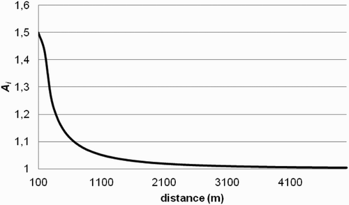
A i is the value of the variable for water presence for each pixel i,
a and b are coefficients whose value is adjusted considering that A i has value 1.5 in the pixel nearest to water and value 1 at a distance of 5000 m.
d k is the distance from pixel i to pixels with water presence (m).
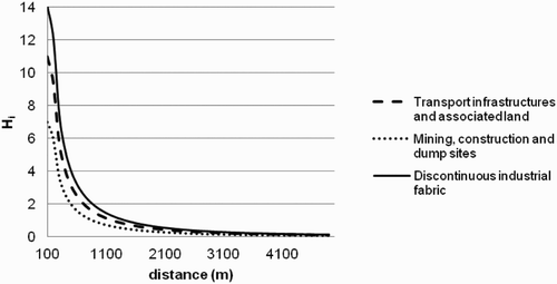
Human activities
Human activities have a negative effect on landscape evaluation. The information on the presence of human activities was also obtained from Corine Land Cover 2000. The land uses ‘discontinuous industrial fabric’, ‘transport infrastructures and associated land’ and ‘mining, construction and dump sites’ were evaluated. Urban areas were not evaluated, as there was insufficient information to decide whether to include them positively or negatively in the final evaluation. The classification of land use corresponding to human activities in the work of CitationOtero Pastor et al. (2007) is not the same as the one used by Corine Land Cover 2000. The reclassification and adaptation of the values assigned to land use was based on the panel of experts noted above.
The variable values, adapted based on the methodology of CitationOtero Pastor et al. (2007) are:
| • | Discontinuous industrial fabric: 14 | ||||
| • | Transport infrastructures and associated land: 11 | ||||
| • | Mining construction and dump sites: 7 | ||||
The variable Hi was taken into account within a neighbourhood in a similar way to those for water presence:
H i is the value of the variable for the presence of human activities for each pixel
a and b are constants whose value is adjusted considering that H i , in the pixel nearest the presence of human activities takes value 14 in the case of discontinuous industrial fabric, 11 in transport infrastructures and 7 in mining, construction and dump sites. In the pixel located at a distance of 5000 m, the value of H i is 0.
d k is the distance from pixel i to the pixels with human activities presence.
The curves obtained are presented in .
Figure 2. Variation of variable H i based on distance to presence of human activities.
Conclusions
The result of this work is a map that evaluates the quality of landscape in Europe by dividing them into seven visual quality classes. The methodology described allowed us to create a landscape quality map for most of the European territory for which geographic information is available. The European landscape quality map we obtained is lacking data in certain areas because the information on which it was based was incomplete. For example, there are no data in the Corine Land Cover version used for Switzerland, Norway, Russia, Turkey and the Kosovo region, and there are no elevation data above 80° latitude in the SRTM DEM.
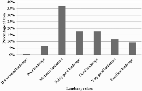
The distribution of the various classes of landscape obtained, expressed as a percentage of the total area, is shown in . The central classes (mediocre, fairly good and good landscapes) represent the largest part of the area, whereas the classes with lower landscape quality (deteriorated and poor landscapes) and with high quality (very good and excellent landscapes) are less abundant. It is worth noting the predominance of the class of ‘mediocre landscapes’ which mainly corresponds to land in farming areas. However, the number of classes in the proposed method makes it possible to see on the map how the value of landscape quality varies in the case of land uses covering less extensive areas, such as the presence of water and human activity, as well as when there is variation in the forms of the terrain.
Figure 3. Percentage of each landscape quality class.
This map only deals with the physical component of landscape quality assessment. Aesthetic and psychological attributes are difficult to map on the scale of this work, and tend to be assessed by means of photographs at a more detailed working scale (CitationCañas et al., 2009). Given the broad geographic extension and the cultural and ecological diversity of the territory analysed, it must be understood as a complementary tool which should be completed with other information sources – such as artistic, cultural and historical – before being applied to the assessment or planning processes.
Software
ESRI ArcGIS 9.X and ESRI ArcInfo Workstation were used as the analysis platform for this project. ESRI ArcGIS 9.X was used to create the maps.
tjom_a_668763_sup_24778266.pdf
Download PDF (5.1 MB)Acknowledgements
The authors would like to thank the European Commission for the funding provided through research project Assessing Sensitiveness to Transport ASSET (6th Framework Program), and the reviewers for their constructive comments. The authors also thank Dr Santiago Mancebo for his advice concerning the processing of the data, and Prudence Brooke-Turner for her translation of this work.
Related Research Data
References
- Aramburu , M.P. , Cifuentes , P. , Escribano , Garcia R.A. and Gonzalez , S. 1994 . Guía para la Elaboración de Estudios del Medio Físico: Contenido y Metodología, Ministerio de Obras Públicas y Transportes . Secretaría de Estado para las Políticas del Agua y el Medio Ambiente, Madrid
- Cañas , I. , Ayuga , E. and Ayuga , F. 2009 . A contribution to the assessment of scenic quality of landscapes based on preferences expressed by the public . Land Use Policy , 26 : 1173 – 1181 .
- CGIAR . 2004 . SRTM 90m Digital Elevation Data V4. Retrieved October 2008, from http://srtm.csi.cgiar.org/SELECTION/inputCoord.asp
- Council of Europe . 2000 . Convenio Europeo del paisaje. Retrieved October 2008, from http://www.mma.es/portal/secciones/desarrollo_territorial/paisaje_dt/convenio_paisaje
- European Environmental Agency . 2007 . Corine Land Cover 2000 100 m - version 9/2007. Retrieved October 2008, from http://dataservice.eea.europa.eu/dataservice/metadetails.asp?id=950
- Meeus , J. H.A. 1995 . Pan-European landscapes . Landscape and Urban Planning , 31 : 57 – 79 .
- Mücher , C. A. , Klijn , J. A. , Wascher , D. M. and Schaminée , J. H.J. 2010 . A new Landscape Classification (LANMAP): a transparent flexible and user-oriented methodology to distinguish landscapes . Ecological Indicators , 10 : 81 – 103 .
- Otero Pastor , I. , Casermeiro Martínez , M. A. , Ezquerra Canalejo , A. and Esparcia Mariño , P. 2007 . Landscape evaluation: Comparison of evaluation methods in a region of Spain . Journal of Environmental Management , 85 : 204 – 214 .
- Palmer , J. F. and Hoffman , R. E. 2000 . Rating reliability and representation validity in scenic landscape assessments . Landscape and Urban Planning , 54 : 149 – 161 .
- Tress , B. , Tress , G. , Decamps , H. and D'Hausteserre , A. M. 2001 . Bridging human and natural sciences in landscape research . Landscape and Urban Panning , 57 : 137 – 141 .
- Wascher , D. M. 2000 . The face of Europe. Policy perspectives for European landscapes, ECNC Technical Report Series. European Centre for Nature Conservation, Tilburg
- Weinstoerffer , J. and Philippe Girardin , P. 2000 . Assessment of the contribution of land use pattern and intensity to landscape quality: Use of a landscape indicator . Ecological Modelling , 130 : 95 – 109 .