Abstract
This paper describes the Geomorphological map of the Tremiti Islands (Puglia, Southern Adriatic Sea, Italy), scale 1:15,000. The Tremiti Islands, located north of Gargano promontory's coast, are part of a complex geological area within the Adriatic basin, facing the junction between the central and southern Apennines. This area is well known for Neogenic-Quaternary stratigraphic, tectonic and seismologic aspects and is crucial for the definition of Late Quaternary Adriatic basin evolution.
The map is the result of a geomorphological study carried out on the islands and the inner continental shelf around them. This study incorporates: (1) field recognition of Quaternary continental deposits and geomorphological mapping, supported by radiometric dating, focused on the morpho-lithostratigraphic correlation of deposits among the different islands and the recognition of landforms that controlled landscape evolution; (2) bathymetric analysis; (3) geomorphological analysis of data from a side scan sonar survey, focused on the recognition of the main submerged landforms, from the coastline down to about 70 m b.s.l.; and (4) scuba-dive geomorphological survey, for improving analysis of geophysical data with direct observations.
The study outlines a complex geological and geomorphologic setting. Despite the small size of the islands, the Quaternary continental succession of the archipelago is characterized by widespread deposits, a result of slope, fluvial and aeolian environments. The landforms of the islands are related to karst, fluvial, marine, and gravitational processes. The inner continental shelf features marine and coastal landforms, but also tectonic, fluvial, karst, and slope landforms. The correlation of the below sea-level geomorphological features with landforms and deposits of above sea-level areas, has provided a contribution to the reconstruction of Late Quaternary landscape and geomorphological evolution, as the result of tectonics, sea-level fluctuations and marine, coastal, and continental geomorphological processes.
1. Introduction
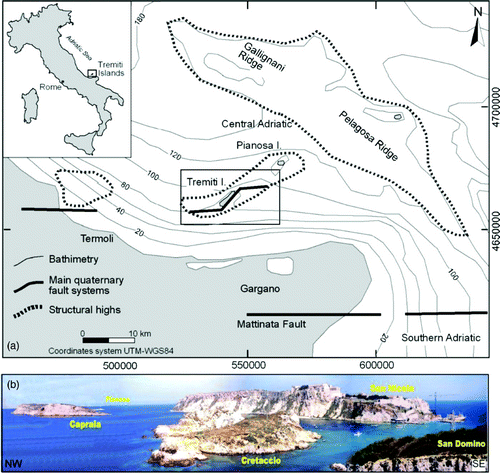
The Tremiti Islands lie in the central-southern Adriatic Sea, in northern Apulia, about 20 km north of the Gargano promontory coast. They include San Domino, San Nicola, Capraia and Cretaccio islands, and La Vecchia rock; Pianosa island, also belonging to the archipelago, is 17 km away from the main islands towards NE (). Being located around the centre of the Adriatic basin, and facing the junction between the central and southern Apennines, the islands lie in a complex geological area, crucial for the study of Quaternary Adriatic basin evolution, strongly driven by eustatic processes and tectonics along well-known regional faults (; CitationDel Gaudio et al., 2007; CitationDoglioni, Mongelli, & Pieri, 1994; CitationFavali, Funiciello, Mattietti, & Salvini, 1993). The archipelago is the emerged part of one of the main structural highs within the Adriatic basin, well studied for erosional/depositional processes on the continental shelf due to Late Quaternary tectonics and eustatic sea-level changes (CitationCattaneo, Correggiari, Langone, & Trincardi, 2003; CitationRidente & Trincardi, 2002).
Figure 1. (a) Physiographic and geological setting of the North Garganic Adriatic sector (from CitationRidente & Trincardi, 2002). (b) Panorama of the islands from San Domino, from SW towards NE.
A detailed integrative geomorphological analysis of the Tremiti Islands (Puglia, Southern Adriatic Sea, Italy), on both the islands and the inner continental shelf around the islands, enabled the production of a geomorphological map (1:15,000 scale) of above and below sea-level areas by means of: (1) field Quaternary continental deposits and geomorphological survey supported by radiometric dating, (2) bathymetric analysis, (3) geomorphological analysis of side scan sonar survey, from the coastline down to about 70 m b.s.l., (4) scuba-dive geomorphological survey.
The geomorphological map incorporates three main sections:
| 1. | main geomorphological map and legend (centre and left on the Map) | ||||
| 2. | geomorphological profiles and morphostratigraphic correlation of Quaternary continental deposits (lower part of the Map) | ||||
| 3. | geomorphological block diagrams and figures (right on the Map). | ||||
The geomorphological analysis presented in this work allowed for the correlation of the inner continental shelf geomorphological features, with landforms and deposits of above sea-level areas of the islands.
The study characterizes deposits and erosion surfaces of the Quaternary continental succession, outlining some new chronological constraints; the main tectonic and geomorphological features, on the surface and in the underwater area, are defined. The geomorphological and stratigraphical data analysis allowed the reconstruction of morphostratigraphic relationships between the islands; moreover, the correlation with tectonic features allowed the reconstruction of the morphotectonic setting of the archipelago.
At a local scale, this correlation has provided a contribution to the reconstruction of the Late Quaternary landscape and geomorphological evolution, as the result of tectonics, sea-level fluctuations and marine, coastal, and continental geomorphological processes.
At a regional scale, this study provides new data useful for the reconstruction of the Quaternary evolution of a foreland area, due to the relationships between tectonic and eustatic processes (CitationLambeck, Antonioli, Purcell, & Silenzi, 2004; CitationRidente & Trincardi, 2006; CitationWaelbroeck et al., 2002), as well as clues and contributions for the correlation between coastal and piedmont areas (CitationAscione, Cinque, Miccadei, Villani, & Berti, 2008; CitationD'Alessandro, Miccadei, & Piacentini, 2003; CitationD'Alessandro, Miccadei, & Piacentini, 2008). Discussion and conclusion coming from this analysis has been presented in two specific research paper on international journals (CitationMiccadei, Mascioli, & Piacentini, 2011a; CitationMiccadei, Mascioli, Orrù, Piacentini, & Puliga, 2011b).
2. The study area
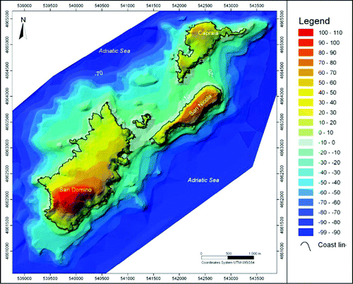
The Tremiti Islands, in the central-southern Adriatic Sea offshore of the Gargano coast, rise from a gentle underwater slope that reaches about 80 m b.s.l. (, ). The submerged slopes of the islands are characterized by a pronounced asymmetry of the inner continental shelf extension, wider in north-western areas and smaller in the south-eastern ones. The islands show a tabular shape, with gentle summit surfaces between 119 m a.s.l. (San Domino) and 55 m a.s.l. (Capraia), bounded by very steep or vertical cliffs (, ).
Figure 2. Bathymetry and orography of the Tremiti Islands and surrounding inner continental shelf.
The archipelago encompasses a Cenozoic marine succession (Paleocene-Middle Pliocene), mainly comprised of limestone with interbedded dolomitic limestone, dolomites and marls (CitationLirer et al., 2002; CitationPampaloni, 1988; CitationSelli, 1971). It is unconformably overlain by a complex Middle Pleistocene and Holocene continental succession made up of clastic deposits, paleosoils, and calcretes (CitationSelli, 1971).
The carbonate Cenozoic succession is in a general SE-dipping homocline setting, regionally coherent with a limb of a NE-SW anticline, faulted several times during the various tectonic stages that involved the uplifted Adriatic-Apulian foreland of the Apennine orogenesis during the Pliocene and Lower Pleistocene (CitationArgnani et al., 1993; CitationArgnani & Frugoni, 1997; CitationDoglioni et al., 1994), with evidence of inversion tectonics (CitationScisciani & Calamita, 2008). The main tectonic discontinuities have E-W, WSW-ENE and NE-SW directions, with strike-slip kinematics, and can be associated with regional discontinuities (; CitationArgnani et al., 1993; CitationDe Alteriis, 1995; CitationFavali et al., 1993). Other fault systems show directions varying from NW-SE to N-S with strike-slip and dip-slip kinematics (CitationBrozzetti, D'Amato, & Pace, 2006; CitationMontone & Funiciello, 1989; CitationSelli, 1971). The Quaternary tectonic activity along these structures is documented in the continental platform (CitationCattaneo et al., 2003; CitationRidente & Trincardi, 2002, Citation2006; CitationRidente, Fracassi, Di Bucci, Trincardi, & Valensise, 2008) and confirmed by intense seismicity with earthquakes (Ms ≤4.0) along E-W to SW-NE tectonic discontinuities (CitationDel Gaudio et al., 2007; CitationDi Bucci et al., 2007; CitationFavali et al., 1992; and references therein).
The geomorphology of the islands is characterized by the complex interaction of gravitational, marine and karst landforms that control landscape evolution and also instability of the marine cliffs (CitationAndriani & Guerricchio, 1996; CitationCotecchia, Guerricchio, & Melidoro, 1996; CitationCotecchia, 1999). Early studies of the karst landforms of the islands began in the 1900s (CitationChecchia-Rispoli, 1916; CitationCresta, Mastronuzzi, Pampaloni, & Sansò, 1999; CitationPasa, 1953; CitationRegnoli, 1974). Karst processes have affected the Quaternary morphogenesis of the islands at least since the Middle Pleistocene, or even since the Eocene (CitationGrassi, Romanazzi, Salvemini, & Spilotro, 1982).
The geomorphology of the inner continental shelf highlights the relationships among long-term geomorphological evolution, Late Quaternary tectonics and eustatic sea-level changes (CitationAntonioli & Ferranti, 1996; CitationLambeck et al., 2004; CitationMiccadei et al., 2011a, Citation2011b). However, the major control comes from coastline variations due to both regional uplift (CitationFerranti et al., 2006; CitationMastronuzzi & Sansò, 2002; CitationParlagreco et al., 2011) and Pleistocene-Holocene eustatic sea-level changes (CitationAntonioli & Vai, 2004; CitationChiocci, D'Angelo, & Romagnoli, 2004; CitationRidente & Trincardi, 2002), that led to alternate periods of emersion and submersion of the area between the islands and the Italian coast.
Taking into account the general geological and geomorphological features of the islands and the inner continental shelf, this work incorporates in a single map emerged and submerged features with integrated analyses and correlations. This aims to provide an improvement to the understanding of the geomorphological evolution of the region, through a morphotectonic analysis of islands and continental shelf.
3. Methods
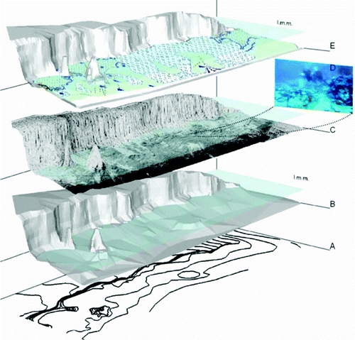
This work is based on a detailed geomorphological analysis of the Tremiti Islands and of the inner continental shelf sea bottom around them, from coastline to about 70 m b.s.l., incorporating: (1) field mapping of Quaternary continental deposits and landforms, supported by U/Th and OSL dating, (2) bathymetric analysis, (3) side scan sonar survey and (4) scuba-dive geomorphological mapping ().
Figure 3. Methods for the creation of the Geomorphological map of the Tremiti Islands overlying: bathymetry (1:15,000) and orography (1:5,000) analysis (A), for the processing of the DTM of the archipelago (B), side scan sonar acquisition (C), geomorphological and Quaternary continental deposits surveys on both the islands and the inner continental shelf around them (D), for the creation of geomorphological map and schemes presented in this work (E).
The field mapping study was carried out by means of a geological survey of Quaternary continental deposits (1:5,000 scale), allowing for the construction of detailed lithostratigraphic logs for each island, and geomorphological survey (1: 5,000 scale, and 1:1,000 for the most significant areas). Field mapping was performed according to the guidelines of Geological Survey of Italy (CitationAPAT, 2007; ISPRA, Citation2009a; CitationSGN, 1994), but upscaling the methods by means of detailed outcrop analysis and logs. Dating of a calcrete and an aeolian deposit supported the morpho-lithostratigraphic correlation of the deposits among the different islands, together with landform studies (CitationMiccadei et al., 2011a).
Bathymetric analysis has been performed processing and interpolating data from nautical cartography of Istituto Idrografico Militare, Piano Nautico n. 204 ‘Isole Tremiti e Pianosa’ (1:15,000 scale). The resulting map has a detail that enables the analysis of the main morphological features and to discriminate flat areas and scarps.
Bathymetric data allowed for plan geomorphological survey of an area of about 9 km2, carried out by means of a side scan sonar records (1:5,000 scale), during the years of 2006 and 2007. Data acquisition has been achieved using an E272 tow-fish transducer apparatus, with 100 kHz frequency, linked together with E260 analogical recorder and RTK mode GPS positioning.
Scuba-dive geomorphological mapping, up to a depth of ∼50 m b.s.l., was carried out according to the guidelines of Geological Survey of Italy (CitationAPAT, 2007; DSTN, 2002; ISPRA, Citation2009b; CitationMonti, Donadio, Putignano, & Toccaceli, 2003) upscaled for detailed mapping by means of specific survey forms to be filled on site (CitationD'Angelo et al., 1996; CitationMonti et al, 2003; CitationOrrù & Ulzega, 1987). The form incorporates different sections: general data (area, sea state and scuba divers), dive conditions, sampling, sea bottom geology, geomorphological features and geomorphological sketch. This allowed for detailed direct observation of inner continental shelf landforms (1:1,000 scale) and the observation of the below sea-level cliff portion and caves, enabling side scan sonar record calibration and improvement (CitationMiccadei et al., 2011b).
Finally, the map and legend were produced on the basis of the above mentioned guidelines (CitationAPAT, 2007; ISPRA, 2009a, 2009b) that already include most of the mapping features (being compiled for 1:10,000 surveys to be converted into 1:50,000 maps), upscaled for the production of a 1:15,000 map with the inclusion of new symbols for marine areas adopted to map landforms noted from the detail survey – such as rock pool, edge and foot of the cliffs, and features connected to biological activity.
4. Geomorphological map
The geomorphological map incorporates three main sections:
| 1. | main geomorphological map featuring Quaternary deposits, tectonic features and geomorphological landforms (centre and left on the Map); | ||||
| 2. | geomorphological profiles and morphostratigraphic correlation of Quaternary continental deposits (lower part of the Map); | ||||
| 3. | geomorphological block diagrams and figures (right on the Map). | ||||
4.1. Quaternary deposits
The geomorphological map includes Quaternary deposits of islands and inner continental shelf areas lying on the Carbonate bedrock.
The bedrock is composed of limestone with interbedded dolomitic limestone, dolomites and marls, stratified or in massive setting pertaining to a Cenozoic marine succession (Paleocene-Middle Pliocene; CitationLirer et al., 2002; CitationPampaloni, 1988; CitationSelli, 1971).
In the inner continental shelf areas (below present sea-level) three main units are mapped:
(1) Silt
Deposits made up of silts and sandy silts from fine to very fine, mostly of silicoclastic composition. They are developed below the lower limit of the storm wave's influence, at more than 50 m b.s.l.
(2) Sand
Deposits made up of bioclastic sands with organogenous fine gravel, due to the activity of calcareous red algae. They are present within the depth range of 30–50 m b.s.l.
(3) Gravel
Deposits of organogenous gravel constituted of fragments of organisms with calcareous shell are developed from the base of rocky cliff down to 30 m b.s.l.
In the continental areas (above present sea-level) the Quaternary succession is mostly pertaining to a continental environment and, despite the small size of the islands, it is characterized by widespread deposits, related to slope, fluvial and aeolian environments. The deposits are generally exposed from sea-level up to the summit of the islands, more than 100 m a.s.l., with a maximum thickness of about 40 m. The Quaternary deposits have different characteristics on each island.
On the basis of the recognition and correlation of different erosion surfaces and lithologies, four main units of Quaternary continental deposits are defined on the map through the morpho-lithostratigraphic correlation scheme (centre right on the map):
(1) Breccia, paleosols, conglomerates and red loess unit
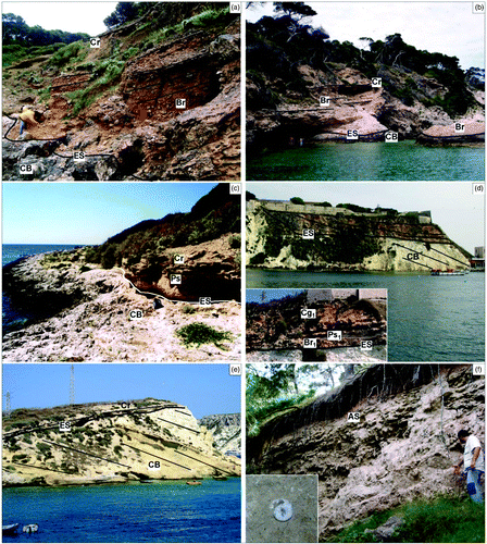
This is a heterogeneous unit including breccias with angular calcareous clasts (Br) and discontinuous levels of sub-rounded pebbles (Cg). Red loess (ls) and paleosols (maximum thickness of 2.5 m) often containing remains of continental molluscs (Ps) that are intercalated (). This unit lies on an erosion surface on carbonate bedrock (ES1, ) and fill pre-existing karst depressions; it is topped by a second erosion surface (ES2). It occurs at about sea-level, on San Domino and Capraia. These deposits are mostly related to slope environments and, according to the presence of Oryctolagus cuniculus, are of Middle Pleistocene age (CitationPasa, 1953; CitationSelli, 1971).
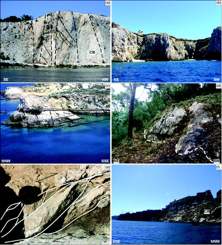
Figure 4. Quaternary continental deposits of the islands (the abbreviations refer to the morpho-lithostratigraphic scheme included in the map) (CitationMiccadei et al., 2011a). (a) San Domino, Cala degli Inglesi (Br – Breccia, paleosols, conglomerates and red loess unit and Cr – Calcretes unit), stratified breccia, formed of decimetric and centimetric clasts, in lightly cemented red-brown sandy matrix, lying on an erosion surface, within pre-existent depressed morphologies on Cenozoic carbonate bedrock. In the higher part calcrete outcrops are about 0.7–0.8 m thick; (b) San Domino, Cala delle Roselle (Br – Breccia, paleosols, conglomerates and red loess unit and Cr – Calcretes unit), stratified breccia with sub-angular centimetric clasts, laying on carbonate bedrock; (c) Capraia, Cala dei Turchi (Br – Breccia, paleosols, conglomerates and red loess unit and Cr – Calcretes unit), paleosols and calcretes outcrop, in contact with carbonate bedrock; (d) San Nicola (Br - Breccia, paleosols, conglomerates and red loess unit), outcrop of breccia, paleosols and conglomerates, stratified in about 0.25 m thick layers; in the lower left a close up of the deposits is included; (e) Cretaccio (CR – Calcretes unit), calcrete in angular discordance on carbonate bedrock, age is 121 ±21 kyr (U/Th dating; CitationMiccadei et al., 2011a); (f) San Domino, Cala delle Roselle (As – Aeolian sand unit), yellow aeolian sand, outcropping within a karst depression (an example of the fossiliferous content is shown in the picture, given by continental gastropods).
(2) Calcretes unit
This unit is made up of laminated and vacuolated calcrete paleosols, white-yellow, some with remnants of polmonate gastropods; the thickness is about 0.70–1 m. In Cretaccio, the unit is composed of a sequence of three levels of calcretes. It lies on the second clear erosion surface (ES2) and is outcropping on all the islands ( providing a useful correlation element. Its formation is dated as the initial part of Upper Pleistocene by the U/Th method (121 ± 21 ka, CitationMiccadei et al., 2011a). On the basis of the morpho-stratigraphic relationship, the calcretes are correlated to a more complete sequence of conglomerates (Cg1), alternating with clayey detrital paleosols (Ps1), and breccia (Br1) (San Nicola island), developed in a second phase of clastic sedimentation, mainly controlled by fluvial processes. The top of the calcretes is characterized by a third erosion surface (ES3) that shows clear evidence of karst landforms.
Aeolian sands unit
This unit, which crops out only at San Domino, is composed of yellow fine and medium aeolian sands, variably rich in clay and silt, which are loose or slightly cemented, with evident cross-bedding (AS). Fossils include continental gastropods (. It lies on the erosion surface ES3 and is closed by a further erosion surface (ES4). The morphostratigraphic relationship indicates that the formation of aeolian sands clearly follows the calcrete deposition, and seems to have occurred in the intermediate part of Upper Pleistocene, as also suggested by OSL analysis (CitationMiccadei et al., 2011a).
Eluvium and colluvium, soils
The youngest unit is made up of eluvium-colluvium and soil deposits (S), mainly argillaceous, dark reddish-brown, that drape the older deposits up to more than 100 m a.s.l. mostly on San Domino and San Nicola. They are limited at the base by the fourth erosion surface (ES4) and are linked to the Holocene on the basis of Neolithic stones tools and ceramic industry (CitationSquinabol, 1908; CitationZorzi, 1958).
4.2. Tectonic features
The field survey on the islands allowed for the collection of data useful for defining the surface features of three main fault systems affecting the Tremiti archipelago.
A NW-SE system affects the carbonate bedrock, with mainly strike-slip kinematics, as evident by the widespread cataclastic rocks (). Faults in the northwest section of San Domino are attributed to this system, in correspondence to the I Pagliai cliff (, and in the northern sector of Capraia (, at the Cala Sorrentino, Cala dei Turchi and Cala Caffè. This system is displaced by SW-NE strike-slip faults along the northern coast of Capraia and in the western sector of Cretaccio (.
Figure 5. Main tectonic elements (CitationMiccadei et al., 2011a). (a) San Domino, I Pagliai, intensely tectonized area, characterized by NW-SE-oriented fault surfaces and cataclastic rocks; (b) Capraia, NW-SE-oriented faults; (c) Cretaccio, NE-SW-oriented faults, characterized by cataclastic rocks; (d) San Domino, Poggio Romito, visible E-W fault plane on carbonate bedrock (CB); (e) San Domino, Cala Tramontana, sigmoid structure indicating right strike-slip kinematic (plan view); (f) San Nicola, tectonic contact between Miocene limestone and marl, in the southeast sector of San Nicola.
Faults with E-W and ENE-WSW directions are characterized by mainly right-lateral strike-slip kinematics. The main evidence is provided by outcropping fault planes ( as well as by wide areas of fault breccia, within which there are centimetric and decimetric sigmoid structures (. These features displace the NW-SE system and are widespread on San Domino, at Poggio del Romito, Cala degli Inglesi, Cala Tramontana, and in the northern sector of Capraia, at the Architiello and Cala dei Turchi.
A further tectonic system, with a WNW-ESE direction, shows mainly dip-slip kinematics and maximum throws of about 25 m. These faults are visible along the entire perimeter of San Nicola and Cretaccio (.
In below sea-level areas the main fault systems are mostly outlined by tectonic landforms such as sub-vertical scarps and bedrock outcrops alignments, connected with high fracturation zones. A first fault system is characterized by E-W orientation and is well represented between San Domino and Capraia or San Nicola islands and in northern and southern San Domino sectors. A minor fault system is outlined by NE-SW alignments on the northern submerged slope of San Domino Island. These two fault systems seem to displace a third one with WNW-ESE to NW-SE orientation, mainly affecting the northern San Domino area.
4.3. Geomorphological landforms
The landforms mapped on the islands and on the inner continental shelf are due to different kind of continental and marine geomorphological processes: slope gravity, fluvial, karst, and marine, with elements due to biological activity also included.
Slope gravity landforms
Several landslides affect the present coastal cliffs of the islands, mostly fall landslides and locally complex ones. They affect almost the whole coast of San Nicola and locally the coast of Capraia and San Domino (see also CitationAndriani, Walsh, & Pagliaruolo, 2005). Below sea-level, slope landforms are also present, well represented in north-western Capraia island sector. Paleolandslides are located between 30 and 40 m b.s.l., and are made of decametric calcareous blocks.
Fluvial landforms
While fluvial deposits are present on the above sea-level part of the islands, fluvial landforms are also present on the inner continental shelf areas, represented by two main gully systems. The deepest one is constituted by SE-NW incisions developed between 35 and over 60 m b.s.l. in carbonate bedrock, showing sub-vertical side scarps; it is located in the north-western side of San Domino, Cretaccio and San Nicola. The shallowest one shows deep incisions and erosion channels, extending from sea level down to about -25 m (. They are characterized by sub-vertical scarps on carbonate bedrock, and are partially filled by gravel to sand deposits, particularly moving towards the deepest sectors. Alluvial fans with decimetric sub-angular elements, usually stabilized and bounded by algal coverage, are located on the 20–25 m b.s.l. surface at the outlet of shallower fluvial incisions (. Alluvial fans lie on the inner part of the wide flat surface at 20–25 m b.s.l. Fluvial incisions also affect slopes and scarps between 20–25 m and 50–55 m b.s.l. and those below 50–55 m b.s.l.
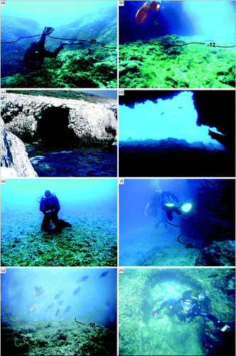
Figure 6. Submerged landforms surveyed by scuba-dive observations on the inner continental shelf (numbers indicate depth) (CitationMiccadei et al., 2011b); (a) Capraia island, incisions and erosional features, between sea-level and about 20 m b.s.l.; (b) San Domino island, detritic fan with centimetric and decimetric calcareous elements, sub-rounded, fossilized by algal fouling. Fan apex is located at about 8 m b.s.l.; the toe lies on the flat marine erosion surface at 20 m b.s.l.; (c) San Domino island, cave at sea-level extending down to 8 m b.s.l. (d) San Domino island, submerged cave at 10 m b.s.l.; (e) Capraia island, flat surface developed between 20 and 25 m b.s.l.; (f) Capraia island, inner margin of flat marine erosion surface observed by bathymetric analysis, at about 20 m b.s.l.; (g) Capraia island, shore platform at 8 m b.s.l.; (h) Metric sub-rounded coastal rockpools, at 8 m b.s.l.
Karst landforms
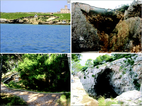
Karst action is evident on the surfaces of the islands, with wide sub-circular depressions. Many potholes are well developed on Capraia, San Domino and San Nicola, at heights that vary from 40 m a.s.l. down to sea-level (. The surface karst landforms also shape the erosional surface at the top of the calcretes. Significant examples are on San Domino, I Pagliai ( and Cala delle Roselle, where karst depressions carved in calcrete are filled by aeolian sandy deposits (.
Figure 7. Geomorphological features on the islands (the abbreviations refer to the Morpho-lithostratigraphic scheme included in the map) (CitationMiccadei et al., 2011). (a) Capraia, partially submerged karst pothole, along the southern coast of the island; (b) San Domino, karst pothole in the north-east sector of the island, with calcretes on top; dashed line indicates a tectonic discontinuity, characterized by NW–SE fault planes and cataclastic rocks (; (c) San Domino, pothole at Cala delle Roselle, partially filled by aeolian sands (AS); (d) San Domino, karst cave at sea-level.
The underground karst is represented by about 50 caves widespread throughout the archipelago, at heights from 0 to about 50 m a.s.l. (.
On the inner continental shelf karst landforms are also present at different bathymetric ranges, affecting rocky sea floor areas on carbonate rocks, and in some cases covered by marine deposits, testifying to continental processes during sea-level lowstands.
On the southern coast of Capraia island dolines are present at 9–15 m b.s.l., partly filled by gravel deposits; dolines and potholes are located also at sea-level and are intensely reshaped by marine erosion. Between San Domino and Capraia islands north of San Domino island, dolines over 100-m wide, filled by sandy and gravelly deposits, are present at 25–35 m b.s.l.. Landforms related to karst-littoral processes are present from sea-level to 20 m b.s.l., consisting of erosion-dissolution channels developed along main high fracturation bedrock zones.
The diving survey enabled the mapping of 40 karst caves, located between sea-level and 50 m b.s.l. About 30 of them are half-submerged (, with bottoms at a 3–7 m b.s.l., covered by centimetre and decimetre-size subrounded pebbles. At lower depths, caves are linked to channels incised in the carbonate bedrock. Other submerged caves are located along the main sub-vertical rocky scarps between the main flat surfaces, at depths of 8–18 m and 25–45 m b.s.l. (. Most of them have small entrances and are mostly <25 m long, without wide chamber. In some cases vertical sections up to 5–6 m long are present. Bottoms of caves located at 8–18 m b.s.l. show centimetre-size rounded pebbles coverage, overlain by pelitic deposits towards the inner part. The deepest cave bottoms (25–45 m b.s.l.) commonly show silt coverage.
Marine landforms
The bathymetry allows the identification of three main flat surfaces at 8–10 m b.s.l., 20–25 m b.s.l., and 50–55 m b.s.l., with it more evident in the north-western areas. The surface at 20–25 m b.s.l. shows the largest extent and lateral continuity around the archipelago. These flat surfaces are bounded by scarps and subvertical slopes, providing a step-like morphology to the inner continental shelf.
The diving survey allowed the definition of the three flat surfaces outlined by bathymetric analysis as marine erosion surfaces related to different paleo sea-levels lower than the present one. The flat surface at 20–25 m b.s.l. is covered by gravelly and sandy marine deposits () and by gravelly alluvial fan deposits (see also , ), with scattered carbonate bedrock outcrops. The inner margin is marked by sub-vertical or steep rocky scarps (. Locally, it is characterized by reefs sub-parallel to the bathymetric trend, morphologically similar to beach-rocks, characterized by a thick seaweed coverage, that are well outlined by the side scan sonar records.
The shallower flat surface shows shore platforms edges located between 8 and 10 m b.s.l., with good inner margin bathymetric correlation and externally bounded by scarps with well defined or irregular and rounded edges (.
The deeper surface (50–55 m b.s.l.) is covered by sand and gravel deposits and is mostly bounded by rounded edges slightly incised by fluvial landforms.
Shore platform surfaces appear to be strongly affected by small erosional landforms, circular coastal rockpools, with diameters varying from some decimeters to over one meter, often open towards deeper areas and connected to drainage channels and coastal erosion landforms (.
Features connected to biological activity
These features are mostly constituted by prairies of Posidonia Oceanica, well developed in the depth range of 5–30 m b.s.l. They show discontinuous coverage, broken by several erosion channels, mostly of anthropogenic origin (anchor lines, fishing).
Thick seaweed coverage, outlined by side scan sonar records, are locally present along the inner part of the marine erosion surface at 20–25 m b.s.l.
5. Conclusion
The Geomorphological map of the Tremiti Islands (Puglia, Southern Adriatic Sea, Italy), scale 1:15,000, is the result of the integrative geomorphological analysis presented in this work, on both the islands and the inner continental shelf around them. This analysis has provided several elements for the understanding of the Quaternary continental deposits and geomorphological features, and of the Pleistocene landscape evolution of the archipelago. Quaternary continental deposits and geomorphological features are summarized in the morpho-litostratigraphic scheme, in the geomorphological profile and in the block diagrams included in the map (lower and lower-right section).
The interpretation of new stratigraphical, geomorphological, chronological data, compared with previous studies in the surrounding areas, indicates a correlation (from islands to inner continental shelf) of subaerial erosion surfaces (ES1, ES2, ES3, ES4) and paleo sea-levels with sea-level change curves (CitationWaelbroeck et al., 2002; CitationLambeck et al., 2004), allowing for an integration of the limited information existing in this area. The main subaerial erosion surfaces, following the oldest one on carbonate bedrock (ES1), are ascribed to late Middle Pleistocene (ES2), Upper Pleistocene (ES3) and Upper Pleistocene-Holocene (ES4). Subaerial erosional processes are evident also in the continental shelf areas, where erosion surfaces bound the transgressive/regressive depositional sequences of the Quaternary marine succession; these surfaces are strongly controlled by eustatic sea-level changes and are linked to subaerial exposure of the platform during the final Middle Pleistocene and Upper Pleistocene sea-level lowstands and Holocene rise (see also CitationRidente & Trincardi, 2006).
Furthermore, the correlation between landform distribution, Quaternary deposits, tectonic features, and eustatic interpretation of morphogenetic processes, provides a new contribution concerning regional tectonics. The SE-NW paleodrainage networks developed during Late Middle Pleistocene (ES2) and Late Upper Pleistocene (ES4) lowstands were followed by tectonic activity during the Middle and Upper Pleistocene, along E-W and SW-NE regional discontinuities. These features have lowered the area between Tremiti and Gargano, beheading the SE-NW Middle Pleistocene fluvial drainage and inducing a strong evolution of the landscape.
More details, discussion and conclusions coming from the geomorphological mapping and the interpretation of the Pleistocene landscape evolution of the Termiti Islands are presented in two research articles (CitationMiccadei et al., 2011a; CitationMiccadei et al., 2011b).
Software
The map presented in this work has had two production phases carried out using different software. In the first phase of map production, vector and raster data (topography, geomorphology, geology, side scan sonar survey, etc.) were managed using ESRI ArcGIS 9.3. In the second phase of map production, the editing was performed using Macromedia FreeHand 10.
tjom_a_668765_sup_24835628.pdf
Download PDF (4.6 MB)Acknowledgements
The authors wish to thank the Cartographic Office of the Puglia Region (http://www.sit.puglia.it), for providing the topographic data used for the geomorphological investigations and for the geomorphological map. This map is the result of research carried out by: E. Miccadei (research guidelines and geomorphological field survey), P. Orrù and G. Puliga (scuba dive and side scan sonar geomorphological survey, T. Piacentini (geomorphological mapping and manuscript realization), F. Mascioli (scuba dive and side scan sonar geomorphological survey, map and schemes editing). The synthesis of the geomorphological data in the map is the result of the contribution of all the authors.
The work was supported by University ‘G. d'Annunzio’ of Chieti Pescara funds (E. Miccadei).
Related Research Data
References
- Andriani , G. F. and Guerricchio , A. 1996 . Caratteri litostratigrafici-tessiturali e geomeccanici delle rocce affioranti nell'Isola di S. Nicola (Isole Tremiti) . Geologia Applicata e Idrogelogia , 31 : 97 – 105 .
- Andriani , G. F. , Walsh , N. and Pagliaruolo , R. 2005 . The influence of the geological setting on the morphogenetic evolution of the Tremiti Archipelago (Apulia, Southeastern Italy) . Natural Hazards and Earth System Science , 5 : 29 – 41 .
- Antonioli , F. and Ferranti , L. 1996 . Evidenze geomorfologiche sommerse nelle aree costiere italiane di uno stazionamento del livello del mare ubicato a circa -20 m e attribuito allo stadio 3' . Il Quaternario, Italian Journal of Quaternary Sciences , 9 ( 1 ) : 205 – 208 .
- Antonioli , F. and Vai , G. B. 2004 . Climex Map Italy – Explanatory notes. Project sponsored by ENEA, directed by C. Margottini and G.B. Vai, 32nd International Geological Congress, Florence, Italy
- APAT Agenzia Nazionale per la Protezione dell'Ambiente . 2007 . Guida alla rappresentazione cartografica della Carta geomorfologica d'Italia, 1:50.000 . Quaderni Serie III del Servizio Geologico d'Italia , 10 p. 177. Roma
- Argnani , A. , Favali , P. , Frugoni , F. , Gasperini , M. , Ligi , M. Marani , M. 1993 . Foreland deformational pattern in the Southern Adriatic Sea . Annali di Geofisica , 36 : 229 – 247 .
- Argnani , A. and Frugoni , F. 1997 . Foreland deformation in the Central Adriatic and its bearing on the evolution of the Northern Apennine . Annali di Geofisica , 40 : 1 – 10 .
- Ascione , A. , Cinque , A. , Miccadei , E. , Villani , F. and Berti , C. 2008 . The Plio-Quaternary uplift of the Apennine chain: New data from the analysis of topography and river valleys in Central Italy . Geomorphology , 102 : 105 – 118 .
- Brozzetti , F. , D'Amato , D. and Pace , B. 2006 . Complessità delle deformazioni neogeniche nell'avampase adriatico: nuovi dati strutturali dalle Isole Tremiti . Rendiconti della Società Geologica Italiana , 2 : 94 – 97 .
- Cattaneo , A. , Correggiari , A. , Langone , L. and Trincardi , F. 2003 . The late-Holocene Gargano subaqueous delta, Adriatic shelf: Sediment pathways and supply fluctuations . Marine Geology , 193 : 61 – 91 .
- Checchia-Rispoli , G. 1916 . Per la conoscenza del fenomeno carsico nel Gargano – terzo contributo . Tipografia della Pace E. Cuggiani, Roma
- Chiocci , F. L. , D'Angelo , S. and Romagnoli , C. 2004 . “ Atlante dei Terrazzi Deposizionali Sommersi lungo le coste italiane ” . In Memorie Descrittive della Carta Geologica d'Italia, 58 Edited by: Chiocci , F. L. , D'Angelo , S. and Romagnoli , C. p. 197. Roma
- Cotecchia , V. 1999 . Geotechnical vulnerability and geological evolution of the Middle Adriatic coastal environment . Rivista Italiana di Geotecnica , 3 : 46 – 55 .
- Cotecchia , V. , Guerricchio , A. and Melidoro , G. 1996 . Geologia e processi di demolizione costiera dell'Isola di S. Nicola . Memorie della Società Geologica Italiana , 51 : 595 – 606 .
- Cresta , S. , Mastronuzzi , G. , Pampaloni , M. L. and Sansò , P. 1999 . “ Le Isole Tremiti ” . Edited by: Richetti , G. and Pieri , P. Guida Geologica Regionale, Puglia e Monte Vulture 108–125. BE.MA, Milano
- D'Alessandro , L. , Miccadei , E. and Piacentini , T. 2003 . Morphostructural elements of central–eastern Abruzzi: Contributions to the study of the role of tectonics on the morphogenesis of the Apennine chain . Quaternary International , 101–102 : 115 – 124 .
- D'Alessandro , L. , Miccadei , E. and Piacentini , T. 2008 . “ Morphotectonic study of the lower Sangro River valley (Abruzzi, Central Italy) ” . Edited by: Silva , P. G. , Audemard , F. A. and Mather , A. E. Impact of active tectonics and uplift on fluvial landscapes and drainage development. Geomorphology, 102, 145–158
- D'Angelo , S. , Lembo , P. , Orrù , P. , Pantaleone , N. A. , Papasodaro , F. Sacchi , L. 1996 . Cartografia geomorfologica alla scala 1:50.000: un esempio nell'area del Golfo di Orosei (Sardegna orientale) . Bollettino del Servizio Geologico d'Italia , 113 : 25 – 38 .
- De Alteriis , G. 1995 . Different foreland basins in Italy: Examples from the Central and Southern Adriatic Sea . Tectonophysics , 252 : 349 – 373 .
- Del Gaudio , V. , Pierri , P. , Frepoli , A. , Calcagnile , G. , Venisti , N. and Cimini , G. B. 2007 . A critical revision of the seismicity of Northern Apulia (Adriatic microplate — Southern Italy) and implications for the identification of seismogenic structures . Tectonophysics , 436 : 9 – 35 .
- Di Bucci , D. , Ravaglia , A. , Seno , S. , Toscani , G. , Fracassi , U. and Valensise , G. 2007 . Modes of fault reactivation from analogue modeling experiments: Implications for the seismotectonics of the Southern Adriatic foreland (Italy) . Quaternary International , 171–172 : 2 – 13 .
- Doglioni , C. , Mongelli , F. and Pieri , P. 1994 . The Puglia uplift (SE-Italy): An anomaly in the foreland of the Apenninic subduction due to buckling of a thick continental lithosphere . Tectonics , 13 ( 5 ) : 1309 – 1321 .
- DSTN Dipartimento per i Servizi Tecnici Nazionali - Servizio Geologico . 2002 . Guida al rilevamento della Carta geologica dei mari italiani alla scala 1:250.000 . Quaderni Serie III del Servizio Geologico d'Italia , 8 p. 94. Roma
- Favali , P. , Funiciello , R. , Mattietti , G. , Mele , G. , Montone , P. Salvini , F. 1992 . Seismotectonic identity of the southern Adriatic area . IGCP , 276 ( 5 ) : 339 – 343 .
- Favali , P. , Funiciello , R. , Mattietti , G. and Salvini , F. 1993 . An active margin across the Adriatic Sea (Central Mediterranean Sea) . Tectonophysics , 219 : 109 – 117 .
- Ferranti , L. , Antonioli , F. , Mauz , B. , Amorosi , A. , Dai Pra , G. Mastronuzzi , G. 2006 . Markers of the last interglacial sea-level high stand along the coast of Italy: Tectonic implications' . Quaternary International , 145–146 : 30 – 54 .
- Grassi , D. , Romanazzi , L. , Salvemini , A. and Spilotro , G. 1982 . Grado di evoluzione e ciclicità del fenomeno carsico in Puglia in rapporto all'evoluzione tettonica . Geologia Applicata e Idrogeologia , 17 ( 2 ) : 55 – 73 .
- ISPRA Istituto Superiore per la Protezione e la Ricerca Ambientale . 2009a . Guida al rilevamento della Carta geologica d'Italia, 1:50.000 . Quaderni Serie III del Servizio Geologico d'Italia , 12 ,I, III p. 166. Roma
- ISPRA Istituto Superiore per la Protezione e la Ricerca Ambientale . 2009b . Progetto CARG: linee guida per il rilevamento geologico, la cartografia e l'informatizzazione dei dati delle aree marine - Scala 1:50.000 . Quaderni Serie III del Servizio Geologico d'Italia , 12, II p. 28. Roma
- Lambeck , K. , Antonioli , F. , Purcell , A. and Silenzi , S. 2004 . Sea-level change along the Italian coast for the past 10,000 yr . Quaternary Science Reviews , 23 : 1567 – 1598 .
- Lirer , F. , Caruso , A. , Foresi , L. M. , Sprovieri , M. , Bonomo , S. Di Stefano , A. 2002 . Astrochronological calibration of the upper Serravallian/Lower Tortonian sedimentary sequence at Tremiti Islands (Adriatic Sea, Southern Italy) . Rivista Italiana di Paleontologia Stratigrafica , 108 ( 2 ) : 241 – 256 .
- Mastronuzzi , G. and Sansò , P. 2002 . Holocene uplift rates and historical rapid sea-level changes at the Gargano promontory . Italian Journal of Quaternary Science , 17 ( 5–6 ) : 593 – 606 .
- Miccadei , E. , Mascioli , F. , Orrù , P. , Piacentini , T. and Puliga , G. 2011b . Late Quaternary paleolandscape of submerged inner continental shelf areas of Tremiti islands archipelago (northern Puglia) . Geografia Fisica Dinamica Quaternaria , 34 ( 2 ) : 223 – 234 .
- Miccadei , E. , Mascioli , F. and Piacentini , T. 2011a . Quaternary geomorphological evolution of the Tremiti Islands (Puglia, Italy) . Quaternary International , 232 : 3 – 15 .
- Monti , L. , Donadio , C. , Putignano , M. L. and Toccaceli , R. M. 2003 . Geologia subacquea delle aree marine costiere. Linee Guida al Rilevamento Geologico Subacqueo, scala 1:10.000. Progetto CARG. Regione Campania. Regione Campania, p. 98
- Montone , C. and Funiciello , R. 1989 . Elementi di tettonica trascorrente alle Isole Tremiti (Puglia) . Rendiconti della Società Geologica Italiana , 12 : 7 – 12 .
- Orrù , P. and Ulzega , A. 1987 . Rilevamento geomorfologico costiero e sottomarino applicato alla definizione delle risorse ambientali (Golfo di Orosei, Sardegna orientale) . Memorie della Società Geologica Italiana , 37 : 471 – 479 .
- Pampaloni , M. L. 1988 . “ Il Paleogene-Neogene delle Isole Tremiti (Puglia, Italia meridionale): stratigrafia ed analisi paleoambientale ” . PhD thesis, 183, Università “La Sapienza” di Roma
- Parlagreco , L. , Mascioli , F. , Miccadei , E. , Antonioli , F. , Gianolla , D. Devoti , S. 2011 . Holocene relative sea level rise along the Abruzzo coast (western central Adriatic) . Quaternary International , 232 : 179 – 186 .
- Pasa , A. 1953 . Appunti geologici per la paleogeografia delle Puglie, (parte Prima) . Memorie Biogeografiche Adriatiche , 2 : 176 – 185 .
- Regnoli , R. 1974 . Isole Tremiti - secondo campo estivo . Sottoterra , 39 : 12 – 14 .
- Ridente , D. , Fracassi , U. , Di Bucci , D. , Trincardi , F. and Valensise , G. 2008 . Middle Pleistocene to Holocene activity of the Gondola Fault Zone (Southern Adriatic Foreland): Deformation of a regional shear zone and seismotectonic implications . Tectonophysics , 453 : 110 – 121 .
- Ridente , D. and Trincardi , F. 2002 . Eustatic and tectonic control on deposition and lateral variability of Quaternary regressive sequences in the Adriatic basin (Italy) . Marine Geology , 184 : 273 – 293 .
- Ridente , D. and Trincardi , F. 2006 . Active foreland deformation evidenced by shallow folds and faults affecting late Quaternary shelf-slope deposits (Adriatic Sea, Italy) . Basin Research , 18 : 171 – 188 .
- Scisciani , V. and Calamita , F. 2008 . Active intraplate deformation within Adria: Examples from the Adriatic region . Tectonophysics , 476 : 57 – 72 .
- Selli , R. 1971 . “ Isole Tremiti e Pianosa ” . In Note illustrative della Carta Geologica d'Italia alla scala 1:100.000 Foglio 156 “S. Marco in Lamis , Edited by: Cremonini , G. , Elmi , C. and Selli , R. 49 – 65 . Roma : Servizio Geologico d'Italia .
- Servizio Geologico Nazionale (SGN) . 1994 . Guida al rilevamento della Carta geomorfologica d'Italia, 1:50.000 . Quaderni Serie III del Servizio Geologico Nazionale , 4, Roma
- Squinabol , S. 1908 . Riassunto di uno studio geo-fisico sulle Tremiti . Atti della Reale Accademia delle Scienze di Torino , 43 : 1008 – 1013 .
- Waelbroeck , C. , Labeyrie , L. , Michel , E. , Duplessy , J. C. , McManus , J. F. Lambeck , K. 2002 . Sea-level and deep water temperature changes derived from benthic foraminifera isotopic records . Quaternary Science Reviews , 21 : 295 – 305 .
- Zorzi , F. 1958 . Tremiti . Rivista di Scienze Preistoriche , 13 : 208 – 209 .