Abstract
This work assessed the spatio-temporal variation of land use in the catchment basins of Fiastra and Salino (central Italy) and its effect on landscape naturalness over a 30-year period (1978–2008). The study area (centroid coordinates 43°7′29.44′′ N; 13°20′34.56′′E) was divided into ecologically homogeneous units (land units) in terms of substrate, bioclimatic belt, and aspect using a GIS-based hierarchical approach for landscape classification and mapping. Land units were characterized from a phytosociological viewpoint, and their naturalness evaluated using the Index of Landscape Conservation status. Comparison of current and past vegetation naturalness of land units was used to prepare the map of changes in landscape naturalness in the Fiastra and Salino catchment basins (central Italy) at a scale of 1:50,000. It was found that, while the change of naturalness in the whole study area was around zero, the pattern of distribution of this change was heterogeneous: naturalness increased in land units of high hilly and mountain belts, mostly because of the spread of woods, to the detriment of shrublands, pre-wooded communities, and grasslands, while the opposite trend was recorded in the alluvial plain and low hills, because of increasing urbanization and landscape homogenization caused by the transformation of grasslands, shrublands, pre-wooded communities, and tree-planted arable lands into arable lands. The hierarchical approach to landscape classification and mapping provided information that could have not been detected by mere calculation of indices. This kind of analysis offers a method for improved interpretation of landscape evolution, affording valuable input for predicting transformation of land use, and thus for formulating sound environmental policies and planning optimum ecosystem management strategies.
1. Introduction
Land use temporal change is one of the most important issues in landscape ecology. Describing and analysing proportional change of different land cover types through time can prove highly valuable, not only for preserving biological diversity, but also for developing general landscape models useful for ecosystem management, environmental policies, and human welfare (CitationChristensen et al., 1996; CitationFranklin, 1993; CitationJobin, Latendresse, Grenier, Maisonneuve, & Sebbane, 2010). It is thought that landscape changes are driven by complex socio-economic interactions (CitationForman, 1995; CitationIrwin & Geoghegan, 2001; CitationWear & Bolstad, 1998; CitationZonneveld, 1995), but environmental factors (first of all, physical and bioclimatic ones) often influence land use as well (CitationBlasi, Smiraglia, & Carranza, 2003). Analysis of environmental features that affect landscape ecology and dynamics can be performed by interpreting the factors that affect a territory in terms of different hierarchically determined spatio-temporal intervals (CitationAllen & Starr, 1982; CitationCatorci, Orsomando, & Silvi, 1995; CitationKing, 1977; CitationO'Neill & King, 1998). Within this process, each element can be interpreted as part of a higher element or as a structure containing systems of lower rank (CitationFarina, 2001). Thus, the multidimensional complexity of ecological systems can be broken down into many organizational levels, each containing only a small number of interacting factors, in which mutual relationships and links between the highest and lowest organizational levels can be modelled (CitationTainton, Morris, & Hardy, 1996), making possible the spatial definition of the ecosystem units through a hierarchical approach (CitationBlasi, Carranza, Frondoni, & Rosati, 2000). In this context, application of methods and concepts of serial and catenal phytosociology (CitationGéhu et al., 1991; CitationOzenda, 1982; CitationRivas-Martínez, 2005b) is useful, since they are based on hierarchical definition and classification of plant communities and landscapes. Phytosociology studies plant communities and their relation with the environment, classifying them in a hierarchical system. Serial phytosociology (synphytosociology) studies the space and time relations that tie together different plant communities (vegetation series or sigmeta), while catenal phytosociology (geosynphytosociology) studies spatial sequences of contiguous vegetation series, within a given bioclimatic belt (geoseries or geosigmeta), that alternate depending on edaphic and topographic gradients that affect them.
On the basis of this theoretical framework, the research aim was to assess the temporal variation of land use and its effect on landscape naturalness over a 30-year period (1978–2008) in a rural landscape of central Italy, using a GIS-based geosynphytosociological approach for landscape classification and mapping.
2. Materials and methods
The study area is located in central Italy (centroid coordinates 43°7′29.44′′ N; 13°20′34.56′′E), at altitudes ranging from 120 to 1530 m a.s.l., and extends over 25,280 hectares. The territory includes several lithotypes: calcareous, marly calcareous, arenaceous, pelitic-arenaceous, clayey- and sandy-pelitic, and alluvial deposits (CitationRegione Marche, 1996–2003). It belongs to the Temperate bioclimatic region (CitationRivas-Martínez, 2008), which is locally divided into three bioclimatic belts (CitationCatorci, Cesaretti, Pancotto, & Vitanzi, 2007) sensu CitationRivas-Martínez (1981) whose main features are shown in . The natural potential vegetation is characterized by deciduous woods in which Quercus pubescens Willd., Ostrya carpinifolia Scop., Quercus cerris L., Carpinus betulus L. or Fagus sylvatica L. subsp. sylvatica play a dominant or a codominant role. The current land use gives rise to patchiness of natural (woods), seminatural (grassland and shrub communities), agricultural (cultivated lands), and urban ecosystems ( and ).
Table 1. Main climatic features of the three bioclimatic belts of the study area. Thermotype and Ombrotype classification follows CitationRivas-Martínez (2008); for number of months of aridity and cold stress calculation Mitrakos' indices (Citation1980, Citation1982) were applied.
Figure 1. View of part of the study area, showing patches of woods and pre-wooded communities in a landscape matrix mainly composed of cultivated lands.
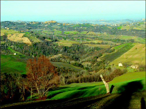
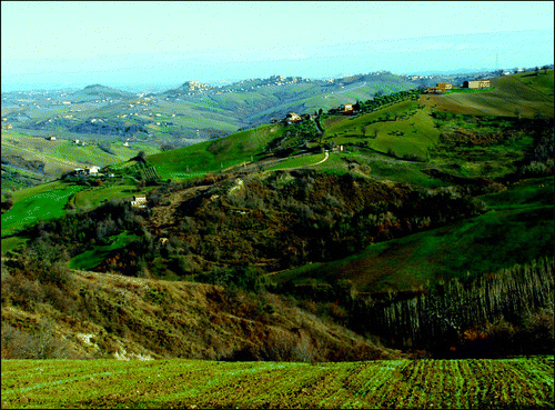
Figure 2. View of part of the study area, showing a mosaic of natural (small woods), seminatural (mainly shrublands), agricultural (cultivated lands), and urban (towns placed mainly on hill tops) ecosystems.
The landscape classification method proposed by CitationBlasi et al. (2000) for describing and mapping Italian landscape at different scales was used for hierarchical interpretation of the study area. This approach was conceived as a system in which pattern and function at each scale level depend on the constraints imposed by the higher levels. From the higher to the lower-scale level, land regions, land systems, land facets, land units, and land elements have to be identified. Land regions are determined by macroclimatic features, because macroclimate is the main factor which influences landform processes as well as vegetation and soil distribution at smaller scales (CitationWalter, 1984). Within each land region, land systems are delimited according to significant lithological discontinuity. At a lower scale, land facets are mainly delimited according to bioclimatic types. Finally, land units are characterized by one phytosociologically determined vegetation series, in which one vegetation type represents the final stage, namely the natural potential vegetation (CitationPignatti, 1995; CitationTomaselli, 1970) of the vegetation dynamics (CitationBiondi, Feoli, & Zuccarello, 2004; CitationGéhu & Rivas-Martínez, 1981; CitationRivas-Martínez, 2005a). Distribution of land units within each land facet in submediterranean landscapes is mainly determined by aspect (CitationVitanzi, Paura, & Catorci, 2009). Each land unit is composed of a mosaic of patches resulting from current and historical anthropic land use (land elements).
In order to conduct hierarchical assessment of the study area, the following thematic maps were drawn at the scale of 1:50,000.
| 1. | Geologic map, in which the main lithotypes, identified using the Geologic Map of the Marches Region (CitationRegione Marche, 1996–2003), were grouped into the following lithological complexes: limestones; marls and calcareous marls; sandstones; pelitic sandstones; sandy-pelits and pelitic-clays; alluvial deposits of ancient terraces; present and recent alluvial deposits. | ||||
| 2. | Phytoclimatic map, in which bioclimatic belts, identified using Rivas-Martínez's bioclimatic indices Citation(2008), were mapped following the methodological approach of CitationBlasi (1994) and CitationOrsomando and Catorci (2000). | ||||
| 3. | Aspect map, derived using a digital elevation model (DEM). Aspect values were categorized into two intervals: west-north-west to east-south-east (0°–112°; 294°–360°); south-east to west (113°–293°). Flat areas were also reported. | ||||
The map of land units (on a scale of 1:50,000) was drawn by overlapping these three thematic maps. The main land cover types of each land unit (woodland, pre-wooded community, shrubland, grassland, tree-planted arable land, arable land, badland, and urban area) were mapped by the interpretation of orthophotos (years 1978 and 2008). Woodlands are wood communities with a dominance of deciduous trees; pre-wooded communities are physiognomically characterized by the contemporary presence of tall shrubs, low shrubs, and low light-demanding trees; shrublands are composed of more or less thick shrubs; grasslands are mainly Bromus erectus or Brachypodium rupestre-dominated communities; tree-planted arable lands are mostly arable lands with rows of trees (Acer campestre), used as a support for vines (); arable lands are fields cultivated with cereals, maize, sunflower, and sugar beet, sometimes with hedges and sparse trees. Moreover, field surveys were carried out in the years 2008–2009 to characterize these physiognomic types from a phytosociological viewpoint, using the Braun-Blanquet method and subsequent updates (CitationBiondi et al., 2004; CitationBraun-Blanquet, 1964; CitationGéhu & Rivas-Martínez, 1981). Field surveys were also conducted to define the natural potential vegetation, and to check the boundaries of each land unit.
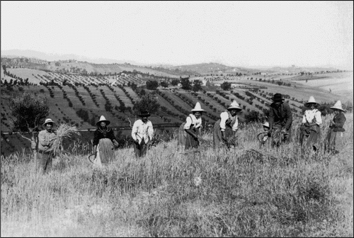
Figure 3. The agricultural landscape of the study area in the first half of the twentieth century. In the background, tree-planted arable lands, with rows of trees used as a support for vines.
Data processing involved the initial formulation of a transition matrix (CitationBlasi et al., 2003) of the main land cover types (1978–2008). To assess the naturalness of each land unit (i.e., distance of the actual vegetation from the potential one) and of the whole study area, the Index of Landscape Conservation status (ILC) was calculated (CitationPizzolotto & Brandmayr, 1996) according to the following formula: ILC = 1 − (∑ x i − 100)/100(n−1), where n is the number of naturalness classes, and x i is the cumulative percent value of the i-th naturalness category. ILC values range from 0 (maximum anthropization) to 1 (maximum naturalness), and are determined by the cumulative percent frequency of 10 previously selected naturalness classes (urban area, arable land, tree-planted arable land, reforestation, badland, grassland, shrubland, pre-wooded community, coppiced woods, mature woods), arranged in ascending order of naturalness (1 for urban areas, and 10 for mature woods). These calculations served for drawing the maps of land unit naturalness (scale 1:50,000), referred to 1978 and to 2008, in which naturalness of land units was categorized in five 0.2 point-wide classes.
The difference of ILC values between 2008 and 1978 (ΔILC) for each land unit was calculated as well. Positive scores (0 < ΔILC ≤ 1) indicate increasing naturalness over time; negative scores (−1 ≤ ΔILC < 0) point out the loss of naturalness and the occurrence of anthropization processes. Shifts in ILC were represented in the map of changes in landscape naturalness in the Fiastra and Salino catchment basins (central Italy). ΔILC values were categorized in five classes. Scales of red or green tones were used for land units with decreasing or increasing naturalness, respectively.
3. Results
Landscape hierarchical classification of the study area made it possible to identify one land region (Temperate region), 7 land systems, 11 land facets, and 18 land units with their respective land elements ().
Table 2. Landscape hierarchical classification of the study area.
Comparison of land cover types in 1978 and 2008 indicated a trend in land use change (). Woodlands increased, as did urban areas, while grasslands decreased. Tree-planted arable lands almost completely disappeared, and were mostly replaced by arable lands (86.5% variation). Other significant transitions occurred from grassland to arable land (39.1%) or woodland (28.5%), and from badland or shrubland and pre-wooded community to woodland (54.4% and 33.9%, respectively). The most stable land use types were urban area (97.9%), arable land (89.3%), and woodland (85.2%).
Table 3. Transition matrix 1978–2008 (transition values are given in percent).
The mean ΔILC in the study area was around zero, so that the overall landscape naturalness remained roughly unchanged from 1978 to 2008. Nevertheless, the rate of change for land units was not constant. Indeed, our data reveal a pattern of variation that depends on the type of land unit. In the high hilly and mountain land units, a general naturalization trend (ΔILC > 0) was recorded. The opposite trend (ΔILC < 0) was observed in the alluvial plain and low hilly territories. Land units that reduced their naturalness were the most common in the study area (63% of the whole surface) and were particularly linked to alluvial deposits, pelitic-arenaceous, sandy-pelitic, and pelitic-clayey substrates.
The landscape naturalness distribution pattern shifted from a homogeneously distributed low naturalness throughout the study area to a clear separation between an area with a low level of naturalness, in low hills and alluvial plains, and a highly natural one, located in the high-hilly and mountainous territories. shows the ΔILC for each land unit.
Table 4. Shifts in Index of Landscape Conservation value between 1978 and 2008 for each land unit (average values).
4. Conclusion
The research outputs demonstrated the usefulness of the hierarchical approach to landscape classification and mapping, for evaluating landscape conservation and identifying spatio-temporal patterns of naturalness changes. This approach yielded a set of information that mere calculation of indexes or transformation matrices fails to provide. Indeed, taking into consideration the ΔILC value calculated for the whole study area (around zero), one would conclude that no significant naturalness variation occurred in the last 30 years. This could lead to misleading conclusions for ecosystem properties assessment, land planning and landscape conservation decision-making. The calculation of ΔILC for each land unit, instead, made it possible to identify different trends depending on the type of land unit and, hence, to visualize patterns of landscape transformation. This kind of analysis could be very valuable for interpreting landscape evolution, also in terms of relationships with socio-economic changes, and, thus, for hypothesizing future scenarios of land use transformation, useful for driving environmental policies and ecosystem management plans.
Software
All the data, including that collected during the fieldwork, was imported, managed, and processed using ESRI ArcGis 9.1 (with 3D Analyst and Spatial Analyst extensions). We compiled a georeferenced database, based on vector objects, organized in shapefiles.
tjom_a_668769_sup_24745512.pdf
Download PDF (4.9 MB)Acknowledgements
This research was supported by funds of ‘The Province of Macerata, Natural Resources and Biodiversity Service’, assigned to Prof. Catorci Andrea. The authors wish to thank: Daniele Sparvoli (Province of Macerata) for help and useful technical support; Sheila Beatty, for linguistic revision; and Dr. Renata Gatti, Paola Galli and Luigi Paradisi for field surveys.
Related Research Data
References
- Allen , T. H.F. and Starr , T. B. 1982 . Hierarchy, perspectives for ecological complexity , Chicago, IL : The University of Chicago Press .
- Biondi , E. , Feoli , F. and Zuccarello , V. 2004 . Modelling environmental responses of plant associations: A review of some critical concepts in vegetation study . Critical Reviews in Plant Sciences , 23 ( 2 ) : 149 – 156 . doi:10.1080/07352680490433277
- Blasi , C. 1994 . Fitoclimatologia del Lazio [Phytoclimatology of Lazio] . Fitosociologia , 27 : 151 – 175 .
- Blasi , C. , Carranza , M. L. , Frondoni , R. and Rosati , L. 2000 . Ecosystem classification and mapping: A proposal for italian landscape . Applied Vegetation Science , 3 : 233 – 242 . doi:10.2307/1479002
- Blasi , C. , Smiraglia , D. and Carranza , M. L. 2003 . Analisi multitemporale del paesaggio all'interno di un sistema di classificazione gerarchica del territorio. Il caso dei Monti Lepini (Italia Centrale) [Multitemporal landscape analysis and hierarchic ecosystem classification. The case of the Lepini Mountains (Central Italy)] . Informatore Botanico Italiano , 35 ( 1 ) : 31 – 41 .
- Braun-Blanquet , J. 1964 . Pflanzensoziologie [Phytosociology] , 3 , New York, NY : Springer .
- Catorci , A. , Cesaretti , S. , Pancotto , D. and Vitanzi , A. 2007 . “ Analisi della vocazionalità del territorio della Comunità Montana di Camerino per la produzione di biomasse solide agro-forestali ad uso energetico [Analysis of the suitability of the territory of the Mountain Community of Camerino for the production of agro-forestry solid biomass for energy use] ” . In Vocazionalità del territorio della Comunità Montana di Camerino per la produzione di biomasse solide agro-forestali ad uso-energetico [Suitability of the territory of the Mountain Community of Camerino for the production of agro-forestry solid biomass for energy use] , Edited by: Catorci , A. , Cesaretti , S. and Marchetti , P. 23 – 60 . Camerino : L'uomo e l'ambiente 47, Università di Camerino .
- Catorci , A. , Orsomando , E. and Silvi , B. 1995 . Il paesaggio vegetale del foglio Nocera Umbra (N. 324 della Carta d'Italia I.G.M., in scala 1: 50.000) [The vegetation landscape of the sheet Nocera Umbra (No. 324 of the Map of Italy I.G.M., scale 1: 50,000)] . Colloques Phytosociologiques , 24 : 665 – 673 .
- Christensen , N. L. , Bartuska , A. M. , Brown , J. H. , Carpenter , S. , D'Antonio , C. Francis , R. 1996 . The report of the Ecological Society of America committee on the scientific basis for ecosystem management . Ecological Applications , 6 : 665 – 691 . doi:10.2307/2269460
- Farina , A. 2001 . Ecologia del paesaggio: Principi, metodi ed applicazioni [Landscape ecology: principles, methods and applications] , Torino : UTET Libreria .
- Forman , R. T.T. 1995 . Land Mosaic , Cambridge : Cambridge University Press .
- Franklin , J. 1993 . Preserving biodiversity: Species, ecosystems or landscapes? . Ecological Applications , 3 ( 2 ) : 202 – 205 . doi:10.2307/1941820
- Géhu , J. M. , Bouzille , J. B. , Bioret , F. , Godeau , M. , Botineau , M. Clement , B. 1991 . Approche paysagere synphytosociologique des marais littoraux du centre-ouest de la France [Synphytosociologic landscape approach to the marshes of central and western coasts of France] . Colloques Phytosociologiques , 17 : 109 – 127 .
- Géhu , J. M. and Rivas-Martínez , S. 1981 . Notions fondamentales de phytosociologie [Fundamentals of phytosociology]. In: H. Dierschke (Ed.) . Berichte der Internationalen Symposien der Internationalen Vereinigung für Vegetationskunde. Proceedings of International Symposium of the International Association for Vegetation Science, Rinteln 1980 (pp. 5–33) Cramer, Vaduz ,
- Irwin , E. G. and Geoghegan , J. 2001 . Theory, data, methods: Developing spatially-explicit economic models of land-use change . Journal of Agriculture Ecosystems and Environment , 85 ( 1–3 ) : 7 – 24 . doi:10.1016/S0167-8809(01)00200-6
- Jobin , B. , Latendresse , C. , Grenier , M. , Maisonneuve , C. and Sebbane , A. 2010 . Recent landscape change at the ecoregion scale in Southern Québec (Canada), 1993-2001 . Environmental Monitoring and Assessment , 164 ( 1–4 ) : 631 – 647 . doi:10.1007/s10661-009-0918-5
- King , A. W. 1977 . “ Hierarchy theory: A guide to system structure for wildelife biologists ” . In Wildlife and landscape ecology: Effects of pattern and scale , Edited by: Bissonette , A. 1717 – 1725 . New York : Springer .
- Mitrakos , K. 1980 . A theory for Mediterranean plant life . Acta Oecologica-Oecologia Plantarum , 1 ( 3 ) : 245 – 252 .
- Mitrakos , K. 1982 . Winter low temperatures in mediterranean-type ecosystems . Ecologia Mediterranea , 8 ( 1–2 ) : 95 – 102 .
- O'Neill , R. V. and King , A. W. 1998 . “ Homage to St. Michael Or, why are there so many books on scale? ” . In Ecological Scale: Theory and applications , Edited by: Peterson , D. L. and Parker , V. T. 4 – 15 . New York, NY : Columbia University Press .
- Orsomando , E. and Catorci , A. 2000 . The phytoclimate of Umbria . Parlatorea , 6 : 5 – 24 .
- Ozenda , P. 1982 . Les Végétaux dans la biosphere [The plants in the biosphere] , Paris : Doin Editeurs .
- Pignatti , S. 1995 . Ecologia vegetale. U.T.E.T., Torino, p. 531
- Pizzolotto , R. and Brandmayr , P. 1996 . An index to evaluate landscape conservation state based on land-use pattern analysis and Geographic Information System techniques . Coenoses , 11 : 37 – 44 .
- Regione Marche . 1996–2003 . Carta geologica regionale: Scala 1: 10.000 [Regional Geologic Map: Scale 1: 10,000]. Regione Marche Giunta Regionale, Servizio Ambiente e Paesaggio. Retrieved March 15, 2011, from http://www.regione.marche.it/Home/Struttureorganizzative/AmbienteePaesaggio/Cartografia/DownloadCartografia/CartaGeologica/tabid/1015/Default.aspx
- Rivas-Martínez , S. 1981 . Les étages bioclimatiques de la végétation de la Péninsule Ibérique [The bioclimatic belts of vegetation of the Iberian Peninsula] . Anales Jardín Botánico Madrid , 37 ( 2 ) : 251 – 268 .
- Rivas-Martínez , S. 2005a . Avances en Geobotanica. Discurso de Apertura del Curso Académico de la Real Academia Nacional de Farmacia del año 2005 [Advances in Geobotany. Opening speech of the Academic course of the Royal Academy of Pharmacy of year 2005]. Retreived April 10, 2011, from http://www.globalbioclimatics.org/book/publications.htm
- Rivas-Martínez , S. 2005b . Notions on dynamic-catenal phytosociology as a basis of landscape science . Plant Biosystems , 139 ( 2 ) : 135 – 144 . doi:10.1080/11263500500193790
- Rivas-Martínez , S. 2008 . Global bioclimatics (Clasificación Bioclimática de la Tierra). Version 01/12/2008. Retreived April 10, 2011, from http://www.globalbioclimatics.org/book/bioc/global_bioclimatics-2008_00.htm
- Tainton , N. M. , Morris , C. D. and Hardy , M. B. 1996 . “ Complexity and stability in grazing systems ” . In The ecology and management of grazing systems , Edited by: Hodgson , J. and Illius , A. W. 275 – 299 . Wallingford : CAB International .
- Tomaselli , R. 1970 . Note illustrative della carta della vegetazione naturale potenziale d'Italia [Notes to the potential natural vegetation map of Italy] . Collana Verde, Ministero Agricoltura e Foreste , 27 : 1 – 63 .
- Vitanzi , A. , Paura , B. and Catorci , A. 2009 . Forest syntaxa spatial distribution hierarchical modelling: Preliminary assessment of a Central Apennine (Italy) landscape . Sauteria , 18 : 311 – 322 .
- Walter , H. 1984 . Vegetation of the Earth and ecological systems of the Geo-Biosphere , Berlin : Springer-Verlag .
- Wear , D. N. and Bolstad , P. 1998 . Land-use changes in Southern Appalachian landscapes: Spatial analysis and forecast evaluation . Ecosystems , 1 : 575 – 594 . doi:10.1007/s100219900052
- Zonneveld , I. S. 1995 . Land ecology: An introduction to landscape ecology as a base for land evaluation, land management and conservation , Amsterdam : S P B Academic Publishing .