Abstract
The Maidens (including the North and Outer Klondyke) are a group of bedrock extrusions about 14 km northeast of Larne, off the coast of Northern Ireland (central point for Maidens Complex: 54°57′50.0, −5°42′20.0). Multibeam echosounder data have been combined with extensive ground-truthing to produce broad-scale substratum and biotope maps for the site. The bathymetry was used to derive rasters of slope gradient, rugosity, aspect, and fine- and broad-scale benthic position index which were used for further analyses with Principal Components Analysis. Ground-truthing data were used to create sample signatures and a Maximum Likelihood Analysis performed to classify the surfaces according to that signature. The supervised classifications generated distributions for three broad-scale substrata and habitat biotopes (six level three biotopes, four level four and one level five biotope). The maps provide critical information and distributions that greatly facilitate the conservation, management and monitoring of a proposed Special Area of Conservation.
Introduction
Knowledge of the distribution and extent of benthic habitats and associated communities is fundamental to marine management, planning and conservation. The EC Habitats Directive (Council Directive 92/43/EEC on the Conservation of natural habitats and of wild fauna and flora) requires specific habitats to be identified for protection and management. These protected sites, known as the Natura 2000 network, are still being selected, and submerged rocky substrata (rocky reef) are one of the habitats of interest. The objective of this work was to map submerged rocky substrata at the Maidens, Northern Ireland, to support its nomination as a marine Special Area of Conservation.
Morphology
The Maidens (including the North and Outer Klondyke) are a group of bedrock extrusions about 14 km northeast of Larne, Northern Ireland (; Main Map) (Eden, Deegan, Rhys, Wright, & Dobson, Citation1973). The Maidens rise as small bedrock outcrops, either awash or just emergent, and in only two cases are they large enough to support a lighthouse – the disused West Maidens lighthouse and the functioning East Maiden lighthouse (CitationCharlesworth, 1963). The shoaling approximately 7.5 km north of the Maidens is called the North Klondyke. A third, smaller shoaling east of the Maidens is referred to locally as the Outer Klondyke.
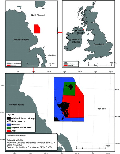
Figure 1. Location of the Maidens/Klondyke outcrop within Northern Ireland and sources for the multibeam echo sounder data used. Central point for Maidens Complex: 54°57′50.0, −5°42′20.0.
Geology
The Maidens and Klondyke extrusions consist of coarse olivine dolerite that crystallised in two stages, the first made up of relatively short strata of fairly basic compositions (labradorite) and enclosed by large crystals of augite, the second consisting of less basic crystals (oligoclase-andesine). In places, the rock displays sheet-jointing dipping roughly westwards at about 10° and is traversed by pronounced vertical joints that delimit the vertical sides of the rocky islands and determine their south-south-west trends (CitationCharlesworth, 1963). The majority of the seabed sediment surrounding the outcrops is coarse sand.
Hydrography
Within the Irish Sea there is a wide range of tidal current strengths. Depth-average values generally exceed 1 m s−1 at spring tides throughout the North Channel. Within the Channel, values in excess of 2 m s−1 can be found near headlands and outcrops such as the Maidens. Due to the shape of the Maidens, eddies and overfalls are also evident. Equally, the outcrops offer shelter from the strong tidal currents, thereby providing a range of tidal and, ultimately, habitat conditions.
Biology
The Northern Ireland Sublittoral Survey was the first comprehensive examination of the seabed habitats of Northern Ireland. CitationErwin et al. (1986) commented on the interesting deep-water species at the Maidens, especially the assemblage characterised by Polyplumaria flabellate, Diphasia pinastrum and Clathria foliate, as well as some individual sites that are particularly diverse.
The recent report by CitationGoodwin, Picton, Breen, and Edwards (2010) provides a thorough examination of the flora and fauna on the three Maidens outcrops. Ninety-four SCUBA dives on the Maidens found over 400 taxa, of which 14 are Northern Ireland Conservation Priority species and 15 are Species of Conservation Concern. CitationGoodwin et al. (2010) found that many of the species recorded from the Maidens occur only here and on Rathlin Island (Northern Ireland). Furthermore, the hydroid communities are particularly noteworthy because there are several nationally scarce Northern Irish Conservation Priority species present, i.e. Diphasia alata, Diphasia nigra, Polyplumaria flabellate, Lytocarpis myriophyllum and Halecium plumosum. CitationGoodwin et al. (2010) also describe an extremely rich sponge fauna at the Maidens, again showing similarity to Rathlin Island and found nowhere else in Northern Ireland. Sponge species listed as Northern Irish Priority species found at the Maidens include Microciona elliptichela and Clarthria barleei. The coarse gravel substratum associated with the Maidens supports four algal species listed as Northern Irish priority species, namely Desmarestia dresnayi, Carpomitra costata, Schmitzia hiscockiana and Stenogramme interrupta.
Methods
Surveys
Multibeam echo sounder survey
Multibeam echo sounder data have been collected from four cruises by three organisations, namely Agri-Food and Biosciences Institute (AFBI), Marine Institute (MI) MESH project and Royal Navy/United Kingdom Hydrographic Office (; Main Map). Multibeam echosounder data were collected by AFBI at three locations during separate cruises covering North Klondyke (repeating the area covered by the Marine Institute in the MESH project), the area surrounding Outer Klondyke and the East and West Maidens (). The Royal Navy surveyed an extensive area from the mouth of Belfast Lough to Glenarm Point, north of the Maidens, and this information has been used to provide coverage of the western side on the Maidens.
Table 1. Component multibeam echo sounder surveys for the Maidens.
North Klondyke multibeam sonar survey (Marine Institute)
A multibeam sonar survey was conducted at the study site using an EM2000 Multibeam Echo Sounder (Kongsberg-Simrad Ltd., Strandpromenaden 50, Horten, Norway). The sonar was operated at a frequency of 200 kHz and ping rate of 10 Hz. It operates with 111 roll stabilised beams per ping, with a 1.5° beam width along track and a 2.5° beam width across track. The system has an angular coverage of 120°.
The EM2000 was deployed with (1) Seapath 200 (Kongsberg-Simrad Ltd., Pirsenteret Trondheim, Norway) for full differential corrections supplied by the IALA GPS network. The GPS derived heading is measured with a 2.5 m beam and 0.075° root mean square (RMS), (2) Seatex MRU5 Motion Reference Unit (Kongsberg-Simrad Ltd.) for roll and pitch accuracies of 0.03° RMS and (3) Applied Microsystems sound velocity meter (Applied Microsystems, 2071 Malaview Avenue, Sidney, BC, Canada) fitted at the sonar head.
Tidal corrections were applied to the multibeam data from 10 minute tide curves modelled using information from the Admiralty Tide Tables and the Hydrographic Office. The tidal models were entered directly into the navigation computer and to the multibeam acquisition software during acquisition so that real-time corrections could be made.
East/West Maidens and Outer Klondyke multibeam sonar survey (AFBI)
This multibeam sonar survey was conducted at both study sites using an EM3002D Multibeam Echo Sounder (MBES, Kongsberg-Simrad Ltd.). However, a dual-head configuration (EM3002D) was used for the the East/West Maidens whereas a single sonar head (EM3002) was used for the Outer Klondyke. The sonar uses a frequency of 300 kHz (single head mode) and 293 kHz/300 kHz for the dual head mode. The ping rate is variable but limited to a maximum of 40 Hz. It operates with either a 254 (single head) or 508 (dual head) roll stabilised beam pattern. The system has an angular coverage of 200° in dual-head mode.
For this survey the EM3002 was deployed with a (1) Seapath 200 dGPS unit, (2) MRU5 Motion reference unit and (3) Applied Microsystems singaround sound velocimeter. The data derived from the sonar heads, Seapath 200 and MRU5 were integrated within the SIS acquisition software (Kongsberg-Simrad Ltd). Tidal corrections were applied to the multibeam data from 10 minute tide data from Larne Harbour.
West of the Maidens (Royal Navy)
The area covered by the Royal Navy survey used an EM1002 Kongsberg-Simrad Ltd. sonar system with SIS data capture software. A CNAV system (730 East Kaliste Saloom Road, Lafayette, LA 70508, USA) was used for motion reference and dGPS positioning.
MBES post-processing software and method
All post-processing and data joining was undertaken within CARIS HIPS and SIPS version 7.02 (CARIS, 115 Waggoner Lane, Fredericton, NB, Canada). Four survey lines of MBES data over the West Maidens were corrupted and could not be processed. The XYZ files used for the ground-type and biotope modelling were exported at 4 metre resolution and gridded in ESRI ArcMap (ESRI, 380 New York Street, Redlands, CA, USA). ESRI tools were also used to calculate slope and aspect layers from the bathymetry. A rugosity layer was generated using the Benthic Terrain Modeller software (CitationWright et al., 2005).
Ground-truthing
Various sources of ground-truthing information have been collated for both ground types and biotopes: survey overviews are provided in .
Table 2. Ground-truthing used for the ground type and biotope classification.
Epibenthic video sledge and drop-frame
Video transects were made using a towed epibenthic video sledge from RV Corystes. Drop-frame and epibenthic sledge tows were approximately 30 minutes long and towed at about 0.5 knot. Dropframe and epibenthic sledge surveys were geo-referenced with a Tracklink 1500 (LinkQuest Inc., 6749 Top Gun Street, San Diego, CA, USA) Ultra Short BaseLine (USBL) system. When this has not been the case, estimations of cable out, depth and ship's heading have been used to correct the layback of the camera platforms. The video and lighting system consisted of a Kongsberg-Simrad Osprey underwater video camera recording directly to DVD. A stills camera system was also fitted to both camera platforms.
In the laboratory, the footage was analysed at 30 second intervals. The percentage of each substratum was quantified along with a SACFOR score (CitationHiscock, 1998) for the dominant fauna. Finally, each section was given a JNCC biotope code using the Joint Nature Conservation Committee (JNCC) Marine Habitat Classification for Britain and Ireland version 04.05 (CitationConnor et al., 2004).
SCUBA dives
Between 2006 and 2008, 94 survey SCUBA dives were undertaken for the Sublittoral Survey of Northern Ireland (SSNI) on the Maidens group and outlying pinnacles (CitationGoodwin, 2010). Divers were experienced field biologists with good knowledge of in situ species identification. Approximately 30 minutes were spent recording species during each dive. Marine Nature Conservation Review (MNCR) phase 2 sublittoral habitat forms were completed to give a record of species and habitats at each site. Conspicuous flora and fauna were noted and specimens collected where in situ identification was not possible. Recording was consistent with MNCR guidelines, with species abundances recorded using the SACFOR scale (CitationHiscock, 1998). Data from the surveys were obtained from the Centre for Environmental Data and Recording (CEDaR).
Map production and habitat mapping
The Benthic Terrain Modeller calculates Bathymetric Position Index (BPI). BPI is a measure of where a location is relative to the surrounding data. BPI data sets are created through a neighbourhood analysis function. Positive BPI cells denote features and regions that are higher than the surrounding area and generally characterise ridges and other associated features within the benthic terrain. Negative cell values within a BPI data set denote features and regions that are lower than the surrounding area, e.g. valleys. BPI values near zero are either flat areas (where the slope is near zero) or areas of constant slope (where the slope of the point is significantly greater than zero) (CitationWright et al., 2005). A fine-scale BPI (scaling factor of 140) and broad-scale BPI (scaling factor of 2000) layers were produced with the Benthic Terrain Modeller. Fine-scale inner and outer annulus radii were 1 and 70, respectively. Broad-scale inner and outer annulus radii were 1 and 1000, respectively. The Iso-cluster analysis in ArcMap was used on the two BPI layers to predict the distribution of the three dominant substrata.
For the production of the predicted biotope distribution, bathymetry, BPI layers, slope, aspect and rugosity were reprocessed with Principal Components Analysis (PCA) and reduced to three components (eigen values for components one, two and three are 4.551732 × 10¹¹, 1.056125 × 10⁴ and 2.200597 × 10³, respectively). All of the biotope ground-truthing was merged into one file and used as a signature sampling file for the three component PCA layers. Maximum Likelihood Analysis was subsequently used to classify the surfaces according to the signature file. ArcMap tool ‘Focal statistics’ (12 × 12 cell neighbourhood) was used to aggregate and clean the classified surface for polygon conversion. Finally, reporting from the biotope extrapolation has been buffered, and thereby limited, to within 2 km of each ground-truthing point.
Conclusions
Morphology
The East and West Maidens outcrop rises from a depth of approximately 90 m to the surface of the sea with drying heights. The North Klondyke is the second largest outcrop and projects from a depth of 125 m to 30 m. The Outer Klondyke has the smallest footprint and the most striking outcrop, rising vertically from 140 m to just 20 m below the sea surface.
Ground types
The broad-scale analysis was used to detect three broad ground types, namely rocky reef outcrop, rock with sand infill and soft sediment – mostly coarse sand (). The distribution of these three broad-scale ground types are shown in the Main Map. For the broad-scale habitat mapping it was felt appropriate to interpolate across the missing data area using expert judgement for the broad-scale analysis. The area of each ground type is shown in (datum is WGS84, projection is Irish National Grid).
Table 3. Area of broad-scale ground types modelled with Bathymetric Position Indices and Iso-cluster analysis (whole survey site).
Biotope mapping
The ground-truthing exercise identified nine biotopes, although SS.SCS.OCS (Offshore circalittoral coarse sediment) has been split into three sub-classes for biotopes for cobble/pebble, gravel/sand and coarse sand-dominated substrata ().
Table 4. Biotope list of the Maidens/Klondyke Complex and the area for each biotope class (within buffered extrapolation area of 2 km radius of ground-truthing points).
The ‘tide-swept circalittoral rock’ biotopes all fall on the rocky reef except for large areas of ‘Flustra foliacea and colonial ascidians on tide-swept moderately wave-exposed circalittoral rock’ that extends NW of the West Maidens on a ridge of boulders and cobbles (Main Map). The biotope ‘Laminaria hyperborea with dense foliose red seaweeds on exposed infralittoral rock’ is located only on clean rocky reef in shallow water. The extensive area of ‘Echinoderms and crustose communities on circalittoral rock’ appears to occur on the deeper and therefore more sheltered rocky reef with infilled ground type. The ‘Offshore circalittoral coarse sediment’ is the most extensive biotope and covers 82% of the survey site ().
The combination of multibeam bathymetry and ground-truthing revealed 26 km2 of rock substrata (including both clean ‘rocky reef’ and areas with a high proportion of coarse sand infill). The potential for areas of the rocky reef with sand infill to be occasionally scoured may mean that the proportion of clean reef and covered reef may occasionally shift over time. The rest of the area was dominated by sand mixed with different amounts of coarse substrata.
The supervised classification of Maidens/Klondyke Complex used six level three biotopes, four level four and one level five. Many of the reef biotopes and species are rare, and some are only found at Rathlin Island and nowhere else in the UK. The presence of these rare species and resulting biotopes is largely due to topography and proximity to deep water creating tidal conditions not found elsewhere in Northern Ireland. The many islets, emergent rocks and submerged pinnacles result in the presence of a wide range of hydrographic conditions, ranging from areas exposed to a 4 knot tidal stream, to more sheltered areas protected from the main tidal flow by the East and West Maidens.
The hydroid biotopes are particularly notable. The proximity of comparatively deep water results in the presence of a suite of deeper water species in much shallower water than they would normally be found. These biotopes include several Northern Ireland Conservation Priority hydroid species such as Diphasia alata, Diphasia nigra, Polyplumaria flabellata, Lytocarpia myriophyllum and Halecium plumosum. These hydroid biotopes are very scarce in Britain and Ireland but appear numerous and widely distributed at the Maidens.
The sponge biotopes are also extremely rich, e.g. CR.HRC.DpSp.PhaAxi. Areas of a deep water sponge community biotope are similar to the sponge communities found on Rathlin Island, and present in only these two areas of Northern Ireland. Again, the sponge communities contain numerous Northern Ireland priority species such as Axinella parva, Lissodendoryx (Ectyodoryx) jenjonsae, Hymedesmia cohesibacilla, Hymdesmia rathlinia, Hymedesmia stellifera, Hymeraphia breeni, and Tethya hibernica. The diversity of species and the presence of these rare species make the sponge biotopes on the Maidens some of the most important in the British Isles.
Rock substrata only represent about 1% of the Northern Irish subtidal habitat area. This mapping effort has made a contribution to understanding where and how much of this rare habitat exists at the Maidens. This type of mapping provides critical distribution information that greatly facilitates the conservation, management and monitoring of a possible Special Area of Conservation.
Software
Sonar acquisition used Seabed Information System (SIS) (Kongsberg-Simrad Ltd) software. All post process and data joining were undertaken within CARIS HIPS and SIPS version 7.02 (CARIS, 115 Waggoner Lane, Fredericton, NB, Canada). Map production was undertaken in ESRI ArcMap (ESRI, 380 New York Street, Redlands, CA, USA).
Supplemental Material - Map
Download PDF (9.2 MB)Acknowledgements
The authors wish to thank David Parker for providing the Royal Navy/United Kingdom Hydrographic Office data for the area surrounding the Maidens. Additional thanks go to Claire Goodwin for providing dive records for the site.
References
- Charlesworth , J. K. 1963 . The olivine-dolerite sill of the Maidens, Co. Antrim . Journal of the Irish Naturalist , 6 : 265 – 73 .
- Connor , D. W. , Allen , J. H. , Golding , N. , Howell , K. L. , Lieberknecht , L. M. Northen , K. O. 2004 . The marine habitat classification for Britain and Ireland (version 04.05) [Internet version] , Peterborough , UK : Joint Nature Conservation Committee . Retrieved July 22, 2010, from www.jncc.gov.uk/MarineHabitatClassification
- Eden , R. A. , Deegan , C. E. , Rhys , G. H. , Wright , J. E. and Dobson , M. R. 1973 . Geological investigations with a manned submersible in the Irish Sea and off Western Scotland 1971 (Institute of Geological Sciences Report No. 73/2). Edinburgh: Institute of Geological Sciences
- Erwin, D.G., Picton, B.E, Connor, D.W, Howson, C.M., Gilleece, P., & Bogues, M.J. (1986). The Northern Ireland Sublittoral Survey. Belfast: Ulster Museum.
- Goodwin , C. , Picton , B. , Breen , J. and Edwards , H. 2010 . The Maidens: Report from the Sublittoral Survey Northern Ireland survey project (May 2006–May 2009) , Belfast : Northern Ireland Environment Agency and National Museums Northern Ireland .
- Hiscock , K. 1998 . Biological monitoring of marine Special Areas of Conservation: A handbook of methods for detecting change , Peterborough , , UK : Joint Nature Conservation Committee .
- Wright , D. J. , Lundblad , E. R. , Larkin , E. M. , Rinehart , R. W. , Murphy , J. Cary-Kothera , L. 2005 . ArcGIS Benthic Terrain Modeller , Corvallis : Oregon State University, Davey Jones Locker Seafloor Mapping/Marine GIS Laboratory and NOAA Coastal Services Center . Retrieved May 8, 2010, from http://www.csc.noaa.gov/products/btm