Abstract
This paper describes the results of topographical and geological surveys carried out at the prehistoric area of Melka Kunture (Ethiopia) in order to produce new detailed maps at a scale of 1:10,000 for supporting archaeological investigations and providing good reference cartography during fieldwork. The topographic support was created from the stereorestitution of two pairs of Standard Stereo IKONOS-2, 1m pan-sharpened satellite imageries covering an area of about 100km2. The topographic map was utilized both for the geological survey and for the interpretation of the palaeo-environmental evolution of the site based on present geomorphological features. The aerial triangulation of satellite images, performed using ground control points measured using differential GPS surveys, allowed the stereoscopic visualization of the area and the creation of a digital elevation model and orthophotos. These results were a useful cartographic aid during the geological survey when all the outcrops along gullies, streams, roads and rivers were inspected and documented through additional in-depth field checks. The geological map was created and refined using the digital elevation model and photointerpretation of stereo and orthoimageries, making it possible to fully identify the geological boundaries between formations and recognize geomorphological features.
1. Introduction
The prehistoric site of Melka Kunture, located 50km south of Addis Abeba close to the Awash village, was discovered by the hydrogeologist G. Dekker in 1963. The following year G. Bailloud, a French archaeologist, carried out the first surface surveys by collecting important lithic implements and faunal remains (CitationBailloud, 1966). From 1965 a Franco-Ethiopian expedition, led by J. Chavaillon, conducted systematic investigations of the site with intensive excavations in some archaeological levels and surface surveys of a larger area where prehistoric finds were discovered. These activities allowed for the preparation of the chronostratigraphy of the Lower and Middle Pleistocene sediments and the study of stone tools and fossil occurrences (CitationChavaillon, 1976; CitationGallotti et al., 2010; CitationMorgan, Renne, Gallotti, Kieffer, Piperno, & Raynal 2012). Excavations were interrupted for approximately 10 years, but started again in some acheulian sites in 1993 under the direction of J. Chavaillon. In 1999 an expedition was headed by Prof. M. Piperno and then from 2011 by Prof. M. Mussi from the Sapienza University of Rome.
Figure 1. Tectonic sketch map of the Main Ethiopian Rift (MER). Inset map shows the relative motion between Nubia and Somalia plates (modified from CitationStamps, Calais, Saria, Hartnady, Nocquet, Ebinger, & Fernandes 2008. A kinematic model for the East African Rift. Geophysical Research Letters, 35, L05304, DOI: 10.1029/2007GL032781. Copyright 2008 American Geophysical Union. Used with permission.)
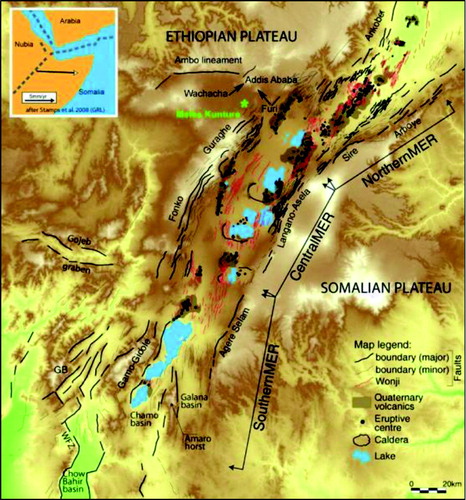
Geologically, Melka Kunture is located in a sliver of structural block along the western margin between the rift floor of the central sector of the Main Ethiopian Rift (MER) and the eastern edge of the NW Ethiopian Plateau south of the EW-trending Ambo lineament (). The geological evolution of the region has been strongly dictated by rifting and volcanic processes as shown by the geomorphic features that, for example, control the direction of the Awash River which crosses the area and flows towards ESE. The Ambo lineament and the Pliocene volcanoes Wachacha and Furi in the northern region (), the rift floor to the east and the Guraghe Mountains to the SE document the complex tectonics and volcanic history of Melka Kunture. Locally the rift is characterized by border faults creating deep, eastward-dipping asymmetrical grabens, rhomb-shaped and pull-apart basins. To the east, the Wonji Fault Belt (CitationAbebe, Mazzarini, Innocenti, & Manetti, 1998; CitationBoccaletti, Getaneh, & Tortorici, 1992; CitationMohr, 1962, Citation1967), a right en-echelon fault axial belt associated with Plio-Quaternary volcanoes, separates the Nubia from the Somalia plate ().
Several authors described the tectonic evolution of the MER as an approximately EW-oriented pure extensional feature (CitationEbinger, Yemane, WoldeGabriel, Aronson, & Walter, 1993; CitationLe Pichon & Francheteau, 1978; CitationMcKenzie, Davies, & Molnar, 1970; CitationMohr, 1983). The initial development of the MER is attributed to the influence of the Afar mantle plume, which lies beneath the Afar Rift and caused basaltic volcanism and uplift of the plateau in two main episodes dated 45–30 and 18–14 million years (Myr) (CitationDavidson & Rex, 1980; CitationEbinger et al., 1993; CitationHart, WoldeGabriel, Walter, & Mertzman, 1989; CitationWoldeGabriel, Aronson, & Walter, 1990). The subsidence of the Ethiopian Rift began during the Middle Miocene with the formation of several half-grabens with a dominant NE orientation (CitationDavidson & Rex, 1980; CitationWoldeGabriel et al., 1990). The main tectonic activity in the northern part of the MER began about 15 Myr ago, while the rifting process in the Red Sea and in the Gulf of Aden occurred during the Palaeogene (i.e. 28 and 35 Myr ago; CitationYirgu, Ebinger, & Maguire, 2006). Rifting activities created symmetrical grabens during the Upper Miocene. Subsequently, frequent Pliocene and Quaternary caldera-forming eruptions filled the grabens and covered the adjacent plains with rhyolitic tephras (CitationKazmin, 1975).
These sequences are clearly visible at Melka Kunture where volcanic records alternate with erosion and sedimentary phases as a result of climatic, volcanic and tectonic activities (CitationChavaillon & Taieb, 1968; CitationTaieb, 1974). The archaeological site is located WNW of a normal regional fault that created a graben partially filled by Pleistocene volcanic and sedimentary deposits. The complete geological sequence of Melka Kunture covers a time span from the Upper Miocene to the Holocene.
2. Materials and methods
Satellite photogrammetry represents a valid alternative to aerial photography for mapping at medium and large scales thanks to the availability of high spatial resolution sensors (CitationDial & Grodecki, 2003; CitationJacobsen, 2004; CitationSperti & Galanti, 2006) that can produce images with high radiometric quality and geometric accuracy (CitationEisenbeiss, Baltsavias, Pateraki, & Zhang, 2004; CitationFraser & Hanley, 2005; CitationPoon, Fraser, Zhang, Gruen, & Zhang, 2005; CitationToutin, Chénier, & Carbonneau, 2001).
In this paper, two pairs of Standard Stereo IKONOS-2 1m pan-sharpened satellite imageries were used to create new topographic and geological maps of the area at a scale of 1:20,000 (Main Map).
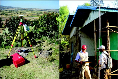
A differential GPS survey was specifically conducted in order to collect Ground Control Points (GCPs) for external orientation and aerial triangulation of IKONOS-2 images. GCPs were selected so that they were uniformly distributed over the study area and easily recognizable (e.g. edge of metal roofs, tukul enclosures). High accuracy and simultaneously appropriate acquisition times were ensured by recording GPS measurements both in differential static mode and in Real Time Kinematic (RTK; ). The static mode, with acquisition times of up to four hours, was referred to the benchmark BNP 267 of the national Ethiopian network located a few kilometres NE of the study area; coordinates and description cards of the trigonometrical station were made available by the Addis Abeba Mapping Agency. Nine new reference stations, uniformly distributed over the area, were set up and measured during the fieldwork. The new stations were used as reference for the RTK measurements that received data-correction through a radio modem; the RTK survey permitted short observation times and rapid surveying. In addition to the GCPs, all the surveyed archaeological field stops, the main archaeological sites and geological sites were measured.
Figure 2. Differential GPS survey: static mode (left) and Real Time Kinematic (right).
The external orientation of satellite scenes was performed using GCPs coordinates and tie points in order to improve the quality of the triangulation process and facilitate the subsequent stereoscopic vision. By utilizing automatic image-matching algorithms and manual stereoscopic editing, the digital elevation model (DEM) was created from the oriented scenes. The DEM was used to generate orthoimages (1m pixel size) and to model 3D photorealistic views for use during geological interpretation. Stereorestitution features such as roads, paths, buildings, tukuls, rivers, contours and spot heights, among others were represented in the topography (see the attached *.pdf map file). Data were organized within a geodatabase, also containing geological sites and both excavated and surface surveyed archaeological sites.
The extent of the topographic data matches the new geological map whose production benefited from fieldwork and currently available maps (CitationAbebe, Manetti, Bonini, Corti, Innocenti, & Mazzarini, 2005; CitationBeshawered, 2009, CitationKazmin, 1972, Citation1975; CitationKazmin & Berhe, 1981; CitationH/Mariam, Getaneh, & Gashaw, 2007; CitationMorgan et al., 2012; CitationRaynal & Kieffer, 2004; CitationTaieb, 1974). During fieldwork outcrops along gullies, streams, roads and rivers were inspected and documented through additional in-depth field checks. This detailed inspection was characterized by descriptive tables, panoramic and detailed pictures of the site, and the measurement of 3D coordinates through a hand-held GPS. More than 80 rock samples were collected during fieldwork for petrographic analyses.
Geological mapping also benefited from stereo and orthoimages and their interpretation refined the boundaries for geological formations and identified morphological features such as escarpments and recent alluvial deposits. After general revision, the map was imported, processed and interpreted within a geographic information system (GIS). A conceptual stratigraphic model and a representative geological section, orthogonal to the main identified tectonic structures, were produced for easier representation of the geological setting. The collected data were projected in the national UTM coordinate system (Spheroid Clarke 1880, Datum Adindan, Zone 37 N) according to the reference system of Ethiopian 1:50,000 topographic maps.
3. Results and discussion
Due to the geometric characteristics of the Standard Stereo IKONOS-2 scenes that have a CE90 horizontal accuracy of 25m and a LE90 vertical accuracy of 22m, their external orientation was executed by means of rational polynomial coefficients (RPC) and by the use of GCPs. The orientation root mean square error (RMSE) for the stereo-products were equal to 0.25 and 0.6 pixels for the northern and the southern pair which correspond, according to the spatial resolution of imagery, to 25 and 60cm. Considering the scale of the maps, these errors were evaluated as satisfactory. The cartographic design of the topographic map followed international standards (e.g. CitationSlocum, McMaster, Kessler, & Howard (2005) and CitationFeldmann (2005)), whilst the geological map followed the Italian Geological Cartographic guidelines (CitationTacchia, 2002). The maps were produced at a scale of 1:10,000 even though the *.pdf file format was prepared at a 1:20,000 scale for printing purposes following ISO standard paper size specifications.
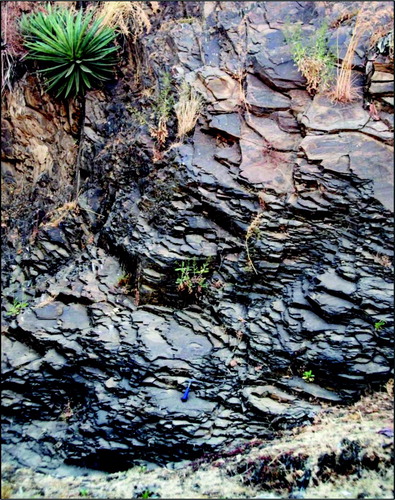
The geological sequence shows the oldest rocks (Upper Miocene) represented by ‘Basalt’ and ‘Acidic to Intermediate Lava’ close to the tectonic lineaments, as indicated by the outcrops along the Melka Kunture fault () and in the northern sector from Buro up to Ilamu village. It is likely that original landforms from this initial activity were not preserved due to severe erosion with tectonic events indicating a long morphological evolution and therefore great age. CitationRaynal & Kieffer (2004) suggest that this activity could be contemporaneous with the Guraghe basalts between 8.3 and 10.6 Myr (CitationWoldeGabriel et al., 1990). Lavas are overlapped by the younger ‘Balchi Obsidian’ chronologically assigned to the Lower Pliocene Wachacha Formation (CitationChernet, Hart, Aronson, & Walter, 1998; CitationWoldeGabriel, Walter, Aronson, & Hart, 1992). The geological sequence is followed by pyroclastites mainly consisting of ‘Welded’ and ‘Non-Welded Ignimbrite’ related to the Lower Pliocene. The ‘Welded Ignimbrite’ is widespread in the Melka Kunture landscape showing different facies and, often, a characteristic prismatic structure while the ‘Non-Welded Ignimbrite’ consists of tuffs and pumiceous flows and fallouts. They occurred in several phases probably contemporaneous with products of other Lower Pliocene volcanoes present in the Melka Kunture environment such as Chilalo, Wachacha, Gara Furi or Yerer (CitationChernet et al., 1998). The next ‘Melka Formation’ is of particular interest for its archaeological finds (Lower-Middle Pleistocene; CitationChavaillon & Taieb, 1968; CitationTaieb, 1974). It crops out in the central region along the Awash River and its tributaries, and it is characterized by sedimentary deposits of fluvial-lacustrine origin alternating with volcanic eruptions of tuffs and pumices. The alternation of these deposits provides stratigraphic reference for correlations among outcrops at different archaeological sites. The ‘Melka Formation’ is overlapped by an extensive event of poorly welded ignimbritic tuff attributable to the ‘Kella Formation’ (Middle Pleistocene; CitationRaynal & Kieffer, 2004).
Figure 3. Acid to intermediate lava flows outcropping at the Melka fault.
In some localities (e.g. Tuka Meja Stream, north and south of Simbiro village) further tuffaceous shales alternate with thin levels of weathered pumices, indicative of minor volcanic events, and alluvial deposits containing volcanic elements. Their stratigraphic position, at the top of the geological sequence, together with the age of archaeological finds, led to the identification of a new geological formation, dated to the Upper Pleistocene–Holocene (CitationChavaillon & Berthelet, 2004; CitationMorgan et al., 2012) and specifically called ‘Tuka Meja Formation’. All the formations are covered by brownish-black alluvial clays (Holocene), the so-called ‘black-cotton-soil’.
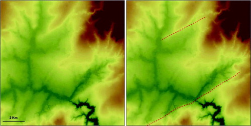
This geological setting conforms with models proposed by previous authors about the development of the Ethiopian rifting process. Alternating volcanic and sedimentary phases were interrupted by periods of intensive erosion during which tectonic and climatic factors influenced morphological evolution and human settlements. The horst and graben structures that characterize the Melka Kunture basin follow the structural rift pattern which is approximately NE SW-oriented. A normal sequence characterizes the study area even if, along tributaries of the Awash River, the outcrops often appear to be reversed due to the palaeo-environmental conditions in which, as already mentioned, phases of deposition and severe erosion alternated. According to this interpretation, it is possible to find recent volcanic deposits within the palaeo-valleys and older formations outcropping at the top of structural heights (see the ‘Conceptual Stratigraphic Scheme’ in the geological map for a graphical representation of the relationships among stratigraphic units). Tectonics make this scheme even more complex; the oldest faults, WE-oriented, are cut by NW–SE faults that, for example, control the incision of the Awash River gorge. The youngest and most evident fault system is NE SW-oriented () as testified by the so-called ‘Melka Fault’ (CitationRaynal & Kieffer, 2004), near the Awash village, which juxtaposes Upper Miocene basalts to Middle Pleistocene ignimbrites.
Figure 4. Morphological evidences of some NE SW-oriented faults represented on the Digital Elevation Model.
4. Conclusions
Integration of data from fieldwork, remote sensing and digital photogrammetry handled within a GIS allowed the production of new topographic and geological maps of the Melka Kunture area, at a scale of 1:10,000, which represent a fundamental tool for studying, managing and preserving such an important archaeological heritage. The site was recently nominated to the UNESCO World Heritage Tentative List as one of the most important African sites of human origin.
The geological survey identified a sequence of volcanic and sedimentary rocks deposited since the Upper Miocene often interrupted by intensive phases of erosion. The geological and structural setting of the area follows the rift structural pattern, about NE SW-oriented, and matches models for its development as proposed by previous authors.
For archaeological purposes, based on the new topography, geology, DEM and multispectral data from satellite images, the new GIS represents a fundamental research tool for the reconstruction of palaeo-environmental paths and settlements in relation to the palaeo-geographic characteristics of the territory. The data obtained will be processed using locational analysis (CitationClevis, Tucker, Lock, Lancaster, Gasparini, Desitter, & Bras, 2006; CitationWheatley & Gillings, 2002) with the goal of proposing a diachronic and synchronic model of settlement, based on the relationship between contemporary sites and the distance from specific environmental variables (e.g. distance from water and raw materials). Future investigations, starting from the analysed variables, could then focus on finding and excavating unexplored remains in such a way as to guarantee the conservation and the safeguarding of this invaluable heritage area. The collected data can also be used for promoting the development of tourism in the area which would bring economic benefits to a community still based on a subsistence economy.
Software
ERDAS IMAGINE 2010 and ESRI ArcMap 9.3 were used during the production of the maps. The first enabled the orientation and aerial triangulation of IKONOS-2 stereoimages and the digital stereoscopic restitution of topographic and geological-geomorphological features, although with the output of the DEM and orthoimagery. ESRI ArcMap was used for the editing of features and the preparation and printing of the final layouts of the thematic map.
Supplemental Material - Map
Download PDF (4.7 MB)Acknowledgements
The authors wish to acknowledge the support of this research by the Sapienza University of Rome, the Ethiopian Oromia Regional State and the European Community through the Culture 2000 Project entitled ‘From the Past to the Present in Ethiopian Prehistory. An Interactive Museum for the Archaeological Park of the Early Palaeolithic Site of Melka Kunture’.
References
- Abebe , T. , Manetti , P. , Bonini , M. , Corti , G. , Innocenti , F. and Mazzarini , F. 2005 . Geological map of the Northern Main Ethiopian Rift , The Geological Society of America, Map and Chart Series MCH094. DOI: 10.1130/2005.MCH094
- Abebe , T. , Mazzarini , F. , Innocenti , F. and Manetti , P. 1998 . The Yerer-Tullu Wellel volcanotectonic lineament: A transtensional structure in central Ethiopia and the associated magmatic activity . Journal of African Earth Sciences , 26 : 135 – 150 .
- Bailloud , G. 1966 . Le gisement paléolithique de Melka-Kontouré (Cahier No. 1). Addis Abeba: Institut Ethiopien d'Archéologie
- Beshawered , E. 2009 . Geological map of Akaki Beseka area , Addis Abeba : Ethiopian Government, Ministry of Mine and Energy, Geological Survey of Ethiopia .
- Boccaletti , M. , Getaneh , A. and Tortorici , L. 1992 . The Main Ethiopian Rift: An example of oblique rifting . Annales Tectonicae , 6 ( 1 ) : 20 – 25 .
- Chavaillon , J. 1976 . Mission archéologiques Franco-ethiopienne de Melka Kunture, Rapport préliminaire 1972–1975 . L'Ethiopie avant l'Histoire , 1 : 1 – 12 .
- Chavaillon , J. and Berthelet , A. 2004 . “ The archaeological sites of Melka Kunture ” . In Studies on the Early Paleolithic site of Melka Kunture, Ethiopia, Origines , Edited by: Chavaillon , J. and Piperno , M. 25 – 80 . Florence , , Italy : Istituto Italiano di Preistoria e Protostoria .
- Chavaillon , J. and Taieb , M. 1968 . Stratigraphie du Quaternaire de Melka-Kunturé, vallée de l'Awash, Ethiopie, Premiers résultats . Comptes Rendus de l'Académie des Sciences, Paris , 266 : 1210 – 1212 .
- Chernet , T. , Hart , W. K. , Aronson , J. L. and Walter , R. C. 1998 . New age constraints on the timing of volcanism and tectonism in the northern Main Ethiopian Rift-southern Afar transition zone (Ethiopia) . Journal of Volcanology and Geothermal Research , 80 : 267 – 280 .
- Clevis , Q. , Tucker , G. , Lock , G. , Lancaster , S. , Gasparini , N. , Desitter , A. and Bras , R. 2006 . Geoarchaeological simulation of meandering river deposits and settlement distributions: A three-dimensional approach . Geoarchaeology , 21 : 843 – 874 .
- Davidson , A. and Rex , D. 1980 . Age of volcanism and rifting in Southwestern Ethiopia . Nature , 283 : 657 – 658 .
- Dial, G., & Grodecki, J. (2003). Applications of Ikonos Imagery. Proceedings of ASPRS Annual Meeting, 5–9 May, Anchorage, Alaska, CD-ROM. Bethesda, Maryland: American Society of Photogrammetry and Remote Sensing.
- Ebinger , C. J. , Yemane , T. , WoldeGabriel , G. , Aronson , J. L. and Walter , R. C. 1993 . Late Eocene–Recent volcanism and faulting in the southern Main Ethiopian Rift . Journal of the Geological Society of London , 150 : 99 – 108 .
- Eisenbeiss, H., Baltsavias, E., Pateraki, M., & Zhang, L. (2004). Potential of Ikonos and Quickbird imagery for accurate 3D point positioning, orthoimage and DSM generation. In O. Altan (Ed.), Proceedings of XX ISPRS Congress, 12–23 July, Istanbul, Turkey, International Archives of Photogrammetry, Remote Sensing and Spatial Information Sciences, 35, B3, (pp. 522–527). ISSN 1682-1750. Organizing Committee of the XXth International Congress for Photogrammetry and Remote Sensing.
- Feldmann, H.U. (2005). Topographic maps – Map graphics and generalization (Cartographic Publication Series No. 17, pp. 3–7, 14–37). Bern, Switzerland: Swiss Society of Cartography.
- Fraser , C. and Hanley , H. 2005 . Bias-compensated RPCs for sensor orientation of high-resolution satellite imagery . Photogrammetric Engineering & Remote Sensing , 71 ( 8 ) : 909 – 915 .
- Gallotti , R. , Collina , C. , Raynal , J. P. , Kieffer , G. , Geraads , D. and Piperno , M. 2010 . The Early Middle Pleistocene site of Gombore II (Melka Kunture, Upper Awash, Ethiopia) and the issue of Acheulean Bifacial Shaping Strategies . African Archaeological Review , 27 ( 4 ) : 291 – 322 .
- Hart , W. K. , WoldeGabriel , G. , Walter , R. C. and Mertzman , S. 1989 . Basaltic volcanism in Ethiopia: Constraints on continental rifting and mantle interactions . Journal Geophysical Research , 94 : 7731 – 7748 .
- H/Mariam, M., Getaneh, A., & Gashaw, K.M. (2007). Geological map of Addis Ababa City. Addis Ababa: Geological Survey of Ethiopia.
- Jacobsen, K. (2004). Orthoimages and DEMs by QuickBird and IKONOS. In R. Goossens (Ed.), Remote sensing in transition (pp. 273–278). Rotterdam, The Netherlands: Millpress.
- Kazmin , V. 1972 . Geological map of Ethiopia , Addis Abeba : Ethiopian Government, Ministry of Mines, Geological Survey of Ethiopia .
- Kazmin , V. 1975 . Explanation of the geological map of Ethiopia , Addis Abeba : Geological Survey of Ethiopia .
- Kazmin , V. and Berhe , S. M. 1981 . Geological map of the Ethiopian Rift , Addis Abeba : Ethiopian Government, Ministry of Mine, Energy and Water Resource, and Ethiopian Institute of Geological Surveys .
- Le Pichon , X. and Francheteau , J. 1978 . A plate-tectonic analysis of the Red Sea–Gulf of Aden area . Tectonophysics , 46 : 369 – 406 .
- McKenzie , D. P. , Davies , D. and Molnar , P. 1970 . Plate tectonics of the Red Sea and East Africa . Nature , 226 : 243 – 248 .
- Mohr , P. 1962 . The Ethiopian Rift system . Bulletin of the Geophysical Observatory Addis Abeba , 5 : 33 – 62 .
- Mohr , P. 1967 . The Ethiopian Rift system . Geophysical Observatory Addis Abeba , 11 : 1 – 65 .
- Mohr , P. 1983 . Ethiopian flood basalt province . Nature , 303 ( 5918 ) : 577 – 584 .
- Morgan, L., Renne, P., Gallotti, R., Kieffer, G., Piperno, M., & Raynal, J.P. (2012). A chronological framework for a long and persistent archaeological record: Melka Kunture, Ethiopia. Journal of Human Evolution, 62(1), 104–115. DOI: 10.1016/j.jhevol.2011.10.007.
- Poon, J., Fraser, C., Zhang, C., Gruen, A., & Zhang, L. (2005). Accuracy evaluation of terrain modelling from Ikonos Stereo imagery. In C. Heipke, K. Jacobsen, & M. Gerke (Eds.). Proceedings of ISPRS Workshop High-Resolution Earth Imaging for Geospatial Information, 14–16 February, Hannover, Germany, International Archives of Photogrammetry, Remote Sensing and Spatial Information Sciences, 36, I/W3, (pp. 5–5). Hannover, Germany: University of Hannover.
- Raynal , J. P. and Kieffer , G. 2004 . “ Lithology, dynamism and volcanic successions at Melka Kunture (Upper Awash, Ethiopia) ” . In Studies on the Early Paleolithic site of Melka Kunture, Ethiopia, Origines , Edited by: Chavaillon , J. and Piperno , M. 111 – 135 . Florence , , Italy : Istituto Italiano di Preistoria e Protostoria .
- Slocum , T. , McMaster , R. , Kessler , F. and Howard , H. 2005 . Thematic cartography and geographic visualization , 2 , 201 – 212 . Upper Saddle River , NJ : Pearson Prentice Hall .
- Sperti , M. and Galanti , R. 2006 . Su una procedura di restituzione a partire da una stereocoppia IKONOS 2 . Bollettino di Geodesia e Scienze Affini , 4 : 229 – 243 .
- Stamps, D.S., Calais, E., Saria, E., Hartnady, C., Nocquet, J.M., Ebinger, C.J., & Fernandes, R. (2008). A kinematic model for the East African Rift. Geophysical Research Letters, 35, L05304, DOI: 10.1029/2007GL032781.
- Tacchia , D. 2002 . Guida all'uso del manuale cromatico di riferimento per la stampa delle carte geologiche . Quaderni del Servizio Geologico d'Italia, Serie III , 11 : 112 Florence, Italy: S.EL.CA
- Taieb , M. 1974 . Evolution quaternaire du basin de l'Awash (Rift éthiopien et Afar) PhD thesis, University of Paris VI
- Toutin, Th., Chénier R. & Carbonneau, Y. (2001). 3D Geometric modelling of IKONOS Geo Images. Proceedings of ISPRS Joint Workshop High Resolution Mapping from Space, Hannover, Germany, CD-ROM (pp. 272–280). Hannover, Germany: Institute of Photogrammetry and Geoinformation, University of Hannover.
- Wheatley , D. and Gillings , M. 2002 . Spatial technology and archaeology: The archaeological applications of GIS , London , , UK : Taylor & Francis .
- WoldeGabriel , G. , Aronson , J. L. and Walter , R. C. 1990 . Geology, geochronology, and rift basin development in the central sector of the Main Ethiopian Rift . Geological Society of America Bulletin , 102 : 439 – 458 .
- WoldeGabriel , G. , Walter , R. C. , Aronson , J. L. and Hart , W. K. 1992 . Geochronology and distribution of silicic volcanic rocks of plio-pleistocene age from the central sector of the Main Ethiopian Rift . Quaternary International , 13–14 : 69 – 76 .
- Yirgu , G. , Ebinger , C. J. and Maguire , P. K.H. 2006 . The Afar Volcanic Province within the East African Rift System (Geological Society of London Special Publications No. 259). London, UK: Geological Society of London