Abstract
On 1 October 2009, a high intensity storm hit the Ionian coast of Sicily, SW of Messina, Italy. The Santo Stefano di Briga rain gauge, located 2 km W of the Ionian coast, recorded 225 mm of rain in seven hours. The intense rainfall event triggered abundant slope failures, and resulted in widespread erosion and deposition of debris along ephemeral drainage channels, extensive inundation, and local modifications of the coastline. Landslides occurred in a territory prone to slope failures, due to the local geological and geomorphological settings. Many landslides were related to the presence of roads lacking adequate drainage. Abandoned terraced slopes lacking proper drainage, and unmaintained dry walls were also related to slope failures. Damage was particularly severe in small villages and at several sites along the transportation network. The shallow landslides and the inundation resulted in 37 fatalities, including 31 deaths and six missing persons, and innumerable injured people. After the event, an accurate landslide inventory map was prepared for the Briga and the Giampilieri catchments. The map shows: (i) the distribution of the event landslides triggered by the 1 October 2009 rainfall event; (ii) the distribution of the pre-existing slope failures; and (iii) other geomorphological features related to fluvial processes and slope movements. The landslide inventory map was prepared at 1:10,000 scale through a combination of field surveys and photo-interpretation of pre-event and post-event, stereoscopic and pseudo-stereoscopic, aerial photography. Different types of aerial photographs were analysed visually to prepare the landslide inventory map. The event landslides were mapped through the interpretation of pseudo-stereoscopic colour photographs taken shortly after the event at 1:3500 scale, combined with digital stereoscopic photographs at approximately 1:4500 scale, taken in November 2009. The pre-event landslides and the associated geomorphological features were mapped using 1:33,000 scale aerial photographs flown in 1954, 1955, and 2005. The event and pre-existing landslides were checked in the field in the period October–November 2009.
Introduction
On 1 October 2009, a high intensity-short duration storm hit the Ionian coast of Sicily, SW of Messina, Italy. The Santo Stefano di Briga rain gauge, located 2 km W of the Ionian coast at an elevation of 139 m, recorded 225 mm of rain in seven hours. The high intensity rainfall triggered abundant slope failures, predominately shallow soil slides and debris flows. The intense rainfall event also resulted in widespread erosion and deposition of debris along ephemeral drainage channels, extensive inundation, and local modifications of the coastline. Damage was extensive and particularly severe in the villages of Giampilieri, Scaletta Zanclea, Guidomandri, Pèzzolo, Altolìa, and Itàla, and at numerous sites along the transportation network. The shallow landslides and the inundations resulted in 37 fatalities, including 31 deaths and six missing persons, and innumerable injured people (CitationSalvati et al., 2010). After the event, an accurate landslide inventory map was prepared through field surveys and photo-interpretation techniques for the Briga and the Giampilieri catchments. The inventory map shows: (i) landslides triggered by the 1 October 2009 high intensity rainfall event; (ii) pre-existing landslides and; (iii) other geomorphological features related to fluvial processes and slope movements.
Study area
The Giampilieri and Briga catchments extend for 19.5 km2 () in the Messina province, along the Ionian coast of Sicily, Italy. The two catchments are located along the eastern-facing slope of the Peloritani Mountains, where nappes of the upper internal complex (Kabilo-Calabride Units), consisting of metamorphic rocks, crop out (CitationCarbone et al., 2008). The study area is characterized by the occurrence of the following stratigraphic units: Mandanici, Mela, and Aspromonte Units (CitationCarbone et al., 2008). From the bottom to the top of the sequence, the Mandanici Unit, is made up of medium- to very low-grade metamorphic rocks (phyllites and metasandstones), belonging to the micaschists Varisic Basament; the Mela Unit, of medium-grade Paleozoic paragneiss and micaschists and the Aspromonte Unit of high- to medium-grade paragneiss and micaschists of pre-Carboniferous age. In the middle part of the Briga river basin, are some scattered outcrops of the Argille Scagliose and San Pier Niceto Formation (Apennine-Maghrebide complex) consisting respectively, of Upper Cretaceous varicoloured clays containing blocks of limestone and quartzarenites and of Miocenic clayey marls and conglomerates. Recent normal faulting activity and sea-level variation controlled the facies distribution and the extent of the Pliocene-Pleistocene marine and alluvial deposits, which capped unconformably the Peloritani nappes. In the area, elevation ranges from sea level to about 1100 m, and terrain gradient is in the range 0°–85°. The catchments exhibit an ephemeral hydrological regime. Climate is Mediterranean in the Messina province, with hot and dry summers, and precipitation falling mostly in the period from October to January. Landslides, including shallow soil slides and debris flows, deep-seated rotational and translational slides, and complex and compound failures, are abundant in the area, and caused primarily by rainfall (CitationGoswami et al., 2011).
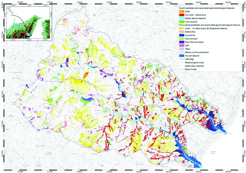
Figure 1. Landslide inventory map for the Briga and the Giampilieri catchments, NE Sicily, Italy.
The landslide inventory map
A landslide inventory map is the simplest form of landslide mapping, and records the location and, where known, the type and date of occurrence of all landslides that have left discernible traces in an area (CitationHansen, 1984; CitationGuzzetti et al., 2000). An inventory map can be prepared using different techniques, depending on the scope, the extent of the study area, the scale of the base maps and the aerial photographs, the quality and detail of the existing information, and the resources available to complete the work (CitationGuzzetti et al., 2000; CitationMondini et al., 2011). For the Briga and the Giampilieri catchments, we prepared a detailed and accurate landslide inventory map at 1:10,000 scale. The inventory was obtained through a combination of: (i) field surveys carried out in the period from October to November 2009, and (ii) visual interpretation of pre-event and post-event stereoscopic and pseudo-stereoscopic aerial photographs. The inventory map shows: (i) the distribution and types of the event landslides triggered by the 1 October 2009 rainfall event, (ii) the distribution and types of the pre-existing landslides, and (iii) information on pre-existing fluvial process and slope movements. Event landslides triggered by the 1 October 2009 rainfall event were mapped through the interpretation of pseudo-stereoscopic colour photographs taken shortly after the event at 1:3500 scale, and digital stereoscopic photographs taken in November 2009 at approximately 1:4500 scale. The pre-event landslides were mapped using 1:33,000 scale aerial photographs flown in 1954, 1955, and 2005 (). The pre-event and the post-event landslide information were checked in the field in the period October–November 2009. Landslides were classified based on the prevalent type of movement (CitationCruden & Varnes, 1996), the estimated depth, and the relative age. Landslide types were determined based on the local morphological characteristics, the appearance on the aerial photographs, and the lithological and structural setting.
Table 1. Characteristics of the stereoscopic and pseudo-stereoscopic aerial photographs used to prepare the landslide inventory map for the Briga and the Giampilieri catchments.
The October 2009 rainfall event triggered mostly shallow, composite soil slide – debris flows and shallow slides. Soil slide – debris flows occurred isolated or clustered in groups of several failures, and affected open slopes and low-order drainage channels. Most of the soil slides occurred on steep slopes where the material was completely mobilized, leaving empty scars. Debris was added by the erosion of the sediments along the slopes and in the channels, increasing velocity and power of the flows. Most of the material was deposited at the base of the slope, where large fans are present.
Shallow slides were mobilized partially, and their movement was made evident by cracks in the source area and by a distinct bulge at the toe. Most of the shallow slides occurred inside pre-existing deep-seated landslides.
Pre-existing landslides are represented by rock falls, topples, debris flows, slides, and complex landslides. Rock falls and topples are located predominantly in the western part of the area, where steep slopes and more resistant rocks are present. The source areas of the rock falls and topples are the result of single events or of multiple events that occurred at different times, and are locally associated with the presence of faults, joints, and multiple cleavage systems. Debris flows are common where debris is abundant along the slopes, such as in tectonized areas, in landslide deposits, and along talus or scree slopes. Where possible, debris flows were mapped separating the source area, the transport area (channel), and the deposition area. In the source areas of debris flows, minor debris slides, rills, and gullies are present locally. Generally, the transport channels coincide with drainage lines. Slides ranging in size from 1.1 × 10² to 2.2 × 10⁵ m2, are abundant, and concentrated in groups. Small slides are mostly shallow translational movements located inside other landslides and along undisturbed slopes. Large slides are deep-seated, rotational and translational slides with a well-defined depletion zone characterized by a concave profile with multiple vertical escarpments and trenches, and a distinct bulging deposit characterized by an irregular or convex profile. Deep-seated landslides involve large volumes of material that affect the local morphology and geological structure. The complex/composite landslide is characterized by the combination of two or more types of movement with a spatial and temporal predominance of one of them.
Recognition of landslides and other geomorphological and hydrological features through the visual interpretation of stereoscopic aerial photographs is a complex operation that requires training, experience, a systematic methodology, and well-defined interpretation criteria. The photo-interpreter identifies and classifies geological objects and geomorphological forms based on experience, and on the analysis of different characteristics that can be identified or inferred from the photographs, including shape, size, colour, tone, mottling, texture, pattern of objects, and site topography (Citationvan Zuidan, 1985). For the Briga and the Giampilieri catchments, visual analysis of the aerial photographs was carried out adopting a well-established procedure. Geomorphologists used mirror ‘double vision’ (or ‘discussion’) stereoscopes with image magnifications ranging from 1.5 × to 13.5 × (CitationCardinali et al., 2001; CitationReichenbach et al., 2005). This type of stereoscope allows for the simultaneous observation of the same pair of stereoscopic photographs by two interpreters, facilitating discussion and reducing interpretation errors. A team of geomorphologists completed the interpretation of the area in a period of four months.
The information obtained from the interpretation of the aerial photographs was drawn on transparent plastic sheets placed over the photographs, and then acquired digitally. Acquisition of the landslide and geomorphological information in digital form was obtained through a process of ‘heads-up’ digitization exploiting GIS software and 1:10,000 scale digital ortho-photographs and topographic base maps. Landslides and the others geomorphological features were digitized as polygons or lines, and coded (labelled) according to their physical properties. For deep-seated landslides, the crown area was mapped separately from the deposit.
Conclusions
Following the high intensity rainfall event that hit the Giampilieri and the Briga catchments, NE Sicily, Italy, on 1 October 2009, a landslide inventory map showing the landslides triggered by the event, and the pre-existing slope failures, in the same general area was prepared. The event landslides occurred in a territory prone to slope failures, due to the local geological and geomorphological setting. Many landslides were related to the presence of roads lacking adequate drainage. Abandoned terraced slopes lacking proper drainage, and unmaintained dry walls were also related to slope failures. Damage in the urban areas was mainly related to insufficient drainage, including the restriction of the channel cross-sections, and the use of drainage lines as roads and walkways.
Landslide inventories are essential to understand the evolution of landscapes, to analyse the spatial and temporal recurrence of mass movements, and to estimate the amount of the remobilized material (CitationGuzzetti et al., 2009; CitationMondini et al., 2011). To prepare event landslide inventory maps it is essential to have adequate aerial photographs, or satellite images of similar characteristics taken immediately or shortly after the event. This is particularly important where the slopes exhibit morphological evidence that is easily and rapidly concealed through the growth of vegetation and weathering. The reduced number of shallow landslides (i.e. soil slides and debris flows) recognized in the pre-event inventory map is attributed to: (i) the type, date, and scale of the aerial photographs, (ii) the average or modal size of these types of failures in the study area, and (iii) the fact that rapid vegetation growth and human action conceal the morphological appearance of the shallow slope failures.
Accurate mapping of the ground effects caused by intense rainfall events provides important information for local administrations and decision makers, to prepare landslide susceptibility and hazard models, and to evaluate landslide erosion rates. The latter is important for regional landscape modelling. In the area affected by the high-intensity storm, during the post-emergency phase, inventory maps have been exploited for the evaluation of the residual risk.
Software
ESRI ArcGIS 9.2 was used to digitize the landslide and geomorphological information collected by aerial photo-interpretation.
Map Design
No specific map design notes are requested.
Supplemental Material - Map
Download PDF (91.9 MB)Acknowledgements
The map was prepared in the framework of the activities realized during the 1 October 2009 event post-emergency phase funded by the Italian Civil Protection Department.
References
- Carbone , S. , Messina , A. , Lentini , F. , Barbano , M. S. , Grasso , D. Di Stefano , A. 2008 . Note Illustrative della Carta Geologica d'Italia alla Scala 1:50.000. Foglio 601 Messina-Reggio di Calabria . Servizio Geologico d'Italia, APAT-Regione Siciliana , 1 : 1 – 179 . S.E.L.CA., Firenze. (in Italian)
- Cardinali , M. , Ardizzone , F. , Galli , M. , Guzzetti , F. and Reichenbach , P. 2001 . “ Landslides triggered by rapid snow melting: The December 1996–January 1997 event in Central Italy ” . In Proceedings 1st EGS Plinius Conference, Maratea , Edited by: Claps , P. and Siccardi , F. 439 – 448 . Cosenza : Bios .
- Cruden , D. M. and Varnes , D. J. 1996 . “ Landslides types and processes ” . In Landslides: Investigation and mitigation. National Research Council, Transportation Research Board. Special Report, 247, 36–75 , Edited by: Turner , A. K. and Schuster , R. L. Washington : National Academy Press .
- Goswami , R. , Mitchell , N. C. and Brocklehurst , S. H. 2011 . Distribution and causes of landslides in the eastern Peloritani of NE Sicily and western Aspromonte of SW Calabria, Italy . Geomorphology , 132 : 111 – 122 . doi: /j.geomorph.2011.04.036
- Guzzetti , F. , Ardizzone , F. , Cardinali , M. , Rossi , M. and Valigi , D. 2009 . Landslide volumes and landslide mobilization rates in Umbria, central Italy, Earth Planet . Scientific Letters , 279 : 222 – 229 . doi: 10.1016/j.epsl.2009.01.005
- Guzzetti , F. , Cardinali , M. , Reichenbach , P. and Carrara , A. 2000 . Comparing landslide maps: A case study in the Upper Tiber River Basin, central Italy . Environmental Management , 25 ( 3 ) : 247 – 263 . doi: 10.1007/s002679910020
- Hansen , A. 1984 . “ Strategies for classification of landslides ” . In Slope Instability , Edited by: Brunsden , D. and Prior , D. B. 523 – 602 . New York : Wiley .
- Mondini , A. C. , Guzzetti , F. , Reichenbach , P. , Rossi , M. , Cardinali , M. and Ardizzone , F. 2011 . Semi-automatic recognition and mapping of rainfall induced shallow landslides using satellite optical images . Remote Sensing of Environment , 115 : 1743 – 1757 . doi: 10.1016/j.rse.2011.03.006
- Reichenbach , P. , Galli , M. , Cardinali , M. , Guzzetti , F. and Ardizzone , F. 2005 . “ Geomorphologic mapping to assess landslide risk: Concepts, methods and applications in the Umbria Region of central Italy ” . In Landslide risk assessment , Edited by: Glade , T. , Anderson , M. G. and Crozier , M. J. 429 – 468 . Chichester , West Sussex : John Wiley & Sons .
- Salvati , P. , Bianchi , C. , Rossi , M. and Guzzetti , F. 2010 . Societal landslide and flood risk in Italy . Natural Hazards and Earth System Sciences , 10 : 465 – 483 . doi: 10.5194/nhess-10-465-2010
- Van Zuidan , R. A. 1985 . Aerial photo-interpretation in terrain analysis and geomorphologic mapping , International Institute for Aerospace Survey and Earth Sciences (ITC). The Hague: Smits, 442 pp