Abstract
Hecates Tholus (centered at 32.1°N 150.2°E), is a shield volcano in the Elysium volcanic province, located in the Martian lowlands in the northern hemisphere. Images of this volcano acquired by the Context Camera (CTX) instrument on board NASA's Mars Reconnaissance Orbiter spacecraft show many glacial landforms that have gone unnoticed by previous authors. We present a geomorphological map of the lower northwestern flank of the Hecates Tholus volcano, at 1:100,000 scale, based on the use and analysis of CTX images with a resolution of 6 meters/pixel. The map is organized into a series of geomorphological units (surface cover) and elements (located at a point, along a line or distributed over an area) in order to provide a clearer understanding of the extent of glacial processes and the main dynamic element of this Martian glacial complex.
1. Introduction
Hecates Tholus is the only large volcano outside the Tharsis region for which various authors have found evidence of glacial activity – past or present. In addition, Hecates Tholus has received less attention from the glacio-geomorphological perspective than the other large volcanoes on Mars.
Most of the main volcanic edifices on Mars show several features that have been described as being produced by glacial processes (e.g., CitationHead & Marchant, 2003; CitationKadish, Head, Parsons, & Marchant, 2008; CitationLucchita, 1981; CitationMilkovich, Head, & Marchant, 2006; CitationShean, Head, & Marchant, 2005; CitationShean, Head, Fastook, & Marchant, 2007; CitationWilliams, 1978; CitationZimbelman & Edgett,1992). Olympus Mons, Arsia Mons, Ascraeus Mons or Pavonis Mons are some examples of Martian volcanoes showing putative glacial features on their flanks or in the nearby surrounding plains. However, all of these are located in the Tharsis volcanic region. Some of the other large volcanoes on Mars, Elysium Mons, Hecates Tholus and Albor Tholus, are located in the Elysium volcanic province (), in the Martian lowlands in the northern hemisphere. Of these three volcanoes, glaciers have been described only on Hecates Tholus (e.g., CitationFassett & Head, 2006, Citation2007; CitationHauber et al., 2005; CitationHelbert, Reiss, Hauber, & Benkhoff, 2005; CitationNeukum et al., 2004), while relief possibly related to the interaction of magma, water and ice (such as sub-glacial volcanoes, mobergs, or chaotic terrains, among others) have been widely described in the Elysium volcanic province and the surrounding area (e.g., CitationCarr, 2006; CitationChapman, 2003; CitationHead, Marchant, Dickson, Kress, & Baker, 2010; Jaumman & Head, 2003; CitationLevy, Head, & Marchant, 2009; CitationNussbaumer, Hauber, & Jaumann, 2004; CitationSoare, Osinski, & Thomson, 2009; among others), marking the important role of water (probably also of ice) in this region of Mars.
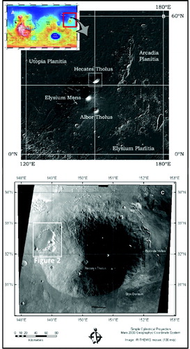
Figure 1. (A) MOLA-derived topographic map of Mars showing the location of the Elysium volcanic province (EVP); (B) MOLA-derived shaded relief map of EVP and the location of Hecates Tholus shield volcano; and (C) Mosaic of THEMIS-IR daytime images of Hecates Tholus volcano and the location of the mapped area (shown in ).
Identification and mapping of glaciers on Mars is more difficult (than on Earth) because in all cases they are covered with glacial debris (dirty-ice) and the research is always dependent on the observation of images. This led to a decades-long discussion about the existence of glaciers on Mars (e.g., CitationCarr, 2006; CitationShean et al., 2005; CitationZimbelman & Edgett, 1992). However, this discussion has been settled and glaciers have been identified. CitationHead et al. (2010) published a geomorphological guide to identifying landforms on Mars in high-resolution images and many authors now accept the existence of glaciers throughout the history of the planet, including in times as recent as 2.1–0.4 Myr during the Late Amazonian (e.g., CitationCarr & Head, 2010; CitationFassett, Dickson, Head, Levy, & Marchant, 2010; CitationHead, Mustard, Kreslavsky, Milliken, & Marchant, 2003).
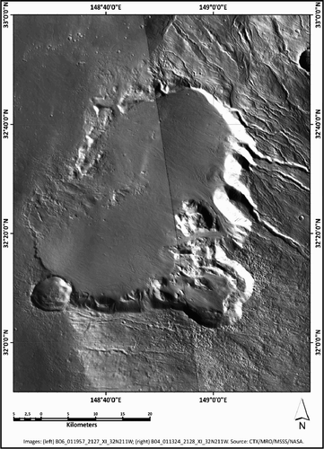
Figure 2. Composition of CTX images of the study area used here to develop the geomorphological cartography (images source: CTX/MRO/MSSS/NASA).
On the other hand, models of the evolution of glaciers (and especially changes in ice thickness) have been built on the basis of geomorphological observations of the tropical volcanoes on Mars, as well as on observations of ice deposits at different latitudes (e.g., CitationHead, Marchant, Agnew, Fassett, & Kreslavsky, 2006a; Head, Nahm, Marchant, & Neukum, 2006b; Head et al., 2010). A wide variety of causes have been considered to explain the location, spatial distribution and ice thickness of the geomorphological features on the flanks and bases of the Martian volcanoes, including orbital, climatic and volcanic processes (e.g., CitationFastook, Head, Marchant, & Forget, 2008; CitationLaskar, Levrard, & Mustard, 2002; CitationLaskar et al., 2004; CitationWilson & Head, 2008).
Hecates Tholus () is a shield volcano located at 32.1°N 150.2°E (MC-7 quadrangle), in the Elysium volcanic province of Mars, in the Martian lowlands in the northern hemisphere. The edifice is about 8000 meters high above the surrounding plains (summit located at about 4600 meters above the Martian Datum). It is slightly elliptic, being 170 × 190 kilometers in diameter at the base, although the lower southern flanks appear to be covered by lava flows from the Elysium Mons volcano (e.g., Citationde Pablo, 2009). Its most recent volcanic episode seems to have occurred between 1000 and 100 Myr (CitationNeukum et al., 2004; CitationHauber et al., 2005), although it has had a long history of magmatic, tectonic and water-related interactions (e.g., CitationFassett & Head, 2006, Citation2007; CitationGulick & Baker, 1989, Citation1990; CitationHauber et al., 2005; CitationKangi, 2007; CitationMouginis-Mark, Head, & Wilson, 1982, 1984; and others summarized in Citationde Pablo, 2009).
As mentioned above, glacial features have been described previously on the flanks of Hecates Tholus. Although a possible ice cap covering the highest part of the edifice has been proposed (CitationFassett & Head, 2006, Citation2007), most of the glacial features are located on the NW flank of the edifice (e.g., CitationHauber et al., 2005; CitationHelbert et al., 2005; CitationNeukum et al., 2004), and mostly on the lower part, related to a nested depression. The main area with glacial elements are, first, an elliptical depression at the base of the volcano (40 × 30 km, SW-NE oriented), and, second, a smaller depression (15 km in diameter) on the middle part of the flank. Following the recent terminology proposed by CitationHead et al. (2010), Lineated Valley Fill and Lobate Debris Aprons have been observed in THEMIS-Vis (18 m/pixel), HRSC (12 m/pixel) and MOC (2 m/pixel) images, as described and mapped previously (e.g., CitationHauber et al., 2005). However, the newly available high-resolution images from CTX and HiRISE instruments on board the NASA's Mars Reconnaissance Orbiter (MRO) now provide sufficient resolution (6 m/pixel and 0.25 m/pixel, respectively) to produce a detailed geomorphological map of those glacial features that could help to understand the glacial and geological history of this area.
The main target of our research was to produce a detailed (1:100,000 scale) geomorphological map of a selected area () of the Hecates Tholus volcanic edifice where glacial features are particularly abundant, the lower NW flank (31.8-33.0°N, 148.37-149.3°E), using CTX images as the base map, since these provide sufficient spatial coverage and resolution to enhance the study reported here. This map adds new information to the previous regional thematic maps of Mars which include this volcano (e.g., CitationHauber et al., 2005; CitationTanaka, Chapman, & Scott, 1992; CitationTanaka, Skinner, & Hare, 2005). This map also provides a basis for future detailed geological and geomorphological studies focused on understanding the geological and climatic history of this region of the planet and the possible relief related to magma, water and ice interactions, with the aim of expanding on the results of previous extensive studies (e.g., CitationCarr & Head, 2010; CitationMouginis-Mark et al., 1982, Citation1984; CitationMouginis-Mark, 1985; CitationMustard, Cooper, & Rifkin, 2001; CitationMustard, 2003, among others).
2. Data, methods and software
Mapping the geomorphological features of the lower NW flank of the Hecates Tholus volcano of Mars was made possible through the analysis of high-resolution images from the CTX instrument on board the MRO spacecraft (NASA: 2006–present). These images were acquired in the visible to near infrared spectrum range (0.5–0.8 µm), with a resolution of about 6 meters per pixel. We used a mosaic of two CTX images: B06_011957_2127_XI_32N211W and B04_011324_2128_XI_32N211W. Although other CTX images covering the study area are available we selected these two because of their high quality (without errors or gaps). These images were obtained through the NASA Planetary Data System (PDS: http://pds.nasa.gov/) and the Mars Space Flight Facility of Arizona State University (ASU-MSFF: http://www.mars.asu.edu/).
During the mapping process, we also used other accessory data to improve our understanding of the geological and geomorphological processes which have affected the volcano. First, a nadir image acquired by the High-Resolution Stereo Camera (HRSC) instrument on board the Mars Express (MEX) spacecraft (ESA: 2003 – present) was used as the basis for co-registration of the CTX images, with a spatial error of 6 meters. Image H2907_0008 (50 m/pixel) was not used for mapping due to its lower spatial resolution compared to the CTX images. We also used an HRSC – derived Digital Elevation Model (DEM), which provides topographic information at 50 m/pixel in resolution (H1262_da4), although it does not cover all of the study area. All these data were obtained through the ESA Planetary Science Archive (ESA-PSA: http://www.rssd.esa.int) and the HRSC Team at the Free University of Berlin (HRSC/FUB: http://hrscview.fu-berlin.de).
The base HRSC image (PDS-IMG in format) was processed using the ESA Mars Express HRSC data to GIS converter (HRSC2GIS tool), developed by J. Oosthoek from the Geological Survey of the Netherlands. Topographic data derived from the HRSC images were also processed using the same tool. Then, the resulting projected HRSC image and HRSC-derived DEM data were incorporated into a Geographic Information System developed for the study area through the use of ArcGIS 9.3 (manufactured by ESRI company). We used this software to derive shaded relief, slope and aspect maps, as well as a contour line map (equidistance of 100 m), useful both in the mapping process, and in the interpretation of the different mapped geomorphological features.
With the GIS, we used the Geographic Coordinate System Mars 2000 spheroid (Semi-major axis: 3396190.0 m; Semi-minor axis: 3376200.0 m; Inverse flattening: 169.894) and the Equidistant Cylindrical projection system with central meridian at 180°. Once the coordinate and projection systems had been established, we included our selected data: the HRSC image, HRSC-derived DEM, and CTX images. The HRSC image was used to manually co-register the CTX image (JPG2000 in format) through the use of ArcGIS 9.3 tools, by including more than 400 control points for co-registration of both images.
3. Geomorphological elements and units
The geomorphological map (elements and units) of the lower NW flank of the Hecates Tholus volcanic edifice is based on texture and relief, using terrestrial analogue sites, and previous geomorphological maps of glacial areas (e.g., CitationEvans, Twigg, Rea, & Orton, 2009; CitationHättestrand & Stroeven, 2002; CitationKjaer, Korsgaard, & Schomacker, 2008; CitationSmith, Rose, & Booth, 2006). In addition, some of the geomorphological features (such as impact craters, ridges, faults or channels, among others) have already been included in the geological maps of Mars at different scales (e.g., Citationde Hon, Mouginis-Mark, & Brickl, 1999; CitationTanaka et al., 1992). In recent times, more detailed studies have been conducted of the Martian surface using the high-resolution images provided by the last missions to Mars. These studies have made it possible to identify and define more features, especially those related to glaciers (e.g., CitationHauber et al., 2005; CitationHelbert et al., 2005; CitationNeukum et al., 2004; CitationPacifici, Komatsu, & Pondrelli, 2009), and also to define and establish their possible origin (CitationHead & Marchant, 2003; CitationHead et al., 2003, Citation2010; Head, Marchant et al., 2006a, Head, Nahm et al., 2006b). Consequently, our geomorphological map is based on previous common practices for geomorphologic mapping of Mars, the most recent geomorphological criteria for glacial features, and terrestrial analogues.
We identified 18 geomorphological elements and 18 geomorphological units (), named in agreement with our interpretation (eskers, moraines, pingos, etc.) and classified according to their origin (glacial, fluvial, impact, etc.). In other words, the geomorphological units mapped here were classified and named according to their origin and main texture (e.g., smooth lava flows, rough slopes, etc.). These units represent terrain sectors characterized by an association of geomorphological elements related to common genetic processes. Units are marked on the map in different colors, with an acronym to identity them clearly on the map.
Table 1. Mapped geomorphological units and elements, and their interpreted origin.
The map also shows the relationship between units and elements according to their origin (). However, some elements are only related to specific units with a similar origin (e.g., crevasse element to glacier unit), meanwhile some other elements are widely distributed throughout all of the geomorphological units (e.g., impact crater or channel elements).
The resulting geomorphological map of the lower NW flank of the Hecates Tholus volcano (1:100,000 scale) contains a brief description of each unit, its spatial distribution and geological/geomorphological interpretation, as well as an image of the study area of each unit.
4. Conclusions
The 1:100,000 scale geomorphological map of the lower NW flank of the Hecates Tholus, based on CTX images, shows that the studied area is rich in possible glacial features (landforms, deposits, etc.), including moraines, covered glacial tongues (or possibly, rocky glaciers), lineated deposits, eskers, drumlins, etc. It also reveals the existence of other interesting relief related to several processes, including: tectonics (ridges, faults and graben, or morphological alignments), fluvial and water-related (gullies, channels, or terraces), periglacial (pingos), gravitational (mass wasting deposits or creeping slopes) and impact-related (impact craters or ejecta deposits) forms. All those features suggest a complex hydrological, climatic and geological history for this volcano in very recent times, perhaps as recent as 0.4 Myr (CitationHauber et al., 2005). A detailed analysis of each feature and its distribution will help to understand the geological evolution of this area and the possible important role of climate, or how changes in climatic conditions may have been responsible for the present surface characteristics.
This map provides a substantial amount of information about the existence and spatial distribution of features not described in previous studies of this area, based on THEMIS-Vis, HRSC (due to their lower resolution), or MOC (due to their low spatial coverage) images.
We hope this geomorphological map will inspire other thematic cartographies of the Martian surface using CTX and HiRISE images, due to their high quality and usefulness for understanding the geological evolution of the Red Planet.
Supplemental Material - Map
Download PDF (87.6 MB)Acknowledgements
The authors thank CTX/MRO/MSSS/NASA and HRSC/MEX/FUB/ESA instrument teams for CTX and HRSC data, respectively. They also thank Dr. Jelmer Oosthoek, from the Geological Survey of the Netherlands, for his tool HRSC2GIS used to process HRSC data.
References
- Carr , M. H. 2006 . The surface of Mars , Cambridge : Cambridge University Press .
- Carr , M. H. and Head , J. W. 2010 . Geologic history of Mars . Earth and Planetary Science Letters , 294 : 185 – 203 .
- Chapman , M. G. 2003 . Sub-ice volcanoes and ancient oceans/lakes: A Martian challenge . Global and Planetary Change , 35 : 185 – 198 .
- de Hon , R. A. , Mouginis-Mark , P. J. and Brickl , E. E. 1999 . Geologic map of the Galaxias quadrangle (MTM 35217) of Mars . USGS Miscellanea Investigation Series , Map I-2579
- de Pablo , M. A. 2009 . Geological cartography of Elysium volcanic region of Mars: Magma-water-climate interactions (PhD thesis) Universidad Rey Juan Carlos, Madrid, Spain
- Evans , D. J.A. , Twigg , D. R. , Rea , B. R. and Orton , C. 2009 . Surging glacier Landsystem of Tungnaarjokull, Iceland . Journal of Maps , v2009 : 134 – 151 . doi:10.4113/jom.2009.1064
- Fassett , C. I. and Head , J. W. 2006 . Valleys on Hecates Tholus Mars: Origin by basal melting of summit snowpack . Planetary and Space Science , 54 : 370 – 378 .
- Fassett , C. I. and Head , J. W. 2007 . Valley formation on Martian volcanoes in the Hesperian: Evidence for melting of summit snowpack, caldera lake formation, drainage and erosion on Ceraunius Tholus . Icarus , 189 : 118 – 135 .
- Fassett , C. I. , Dickson , J. L. , Head , J. W. , Levy , J. S. and Marchant , D. R. 2010 . Supraglacial and proglacial valleys on Amazonian Mars . Icarus , 208 : 86 – 100 .
- Fastook , J. L. , Head , J. W. , Marchant , D. R. and Forget , F. 2008 . Tropical mountain glaciers on Mars: Altitude-dependence of ice accumulation, accumulation conditions, formation times, glacier dynamics, and implications for planetary spin-axis/orbital history . Icarus , 198 : 305 – 317 .
- Gulick , V. C. and Baker , V. R. 1989 . Fluvial valleys and martian paleoclimates . Nature , 341 : 514 – 516 .
- Gulick , V. C. and Baker , V. R. 1990 . Origin and evolution of valleys on Martian volcanoes . Journal of Geophysical Research , 95 : 14325 – 14344 .
- Hättestrand , C. and Stroeven , A. P. 2002 . A relict landscape in the centre of Fennoscandian glaciation: Geomorphological evidence of minimal Quaternary glacial erosion . Geomorphology , 44 : 127 – 143 .
- Hauber , E. , van Gasselt , S. , Ivanov , B. , Werner , S. , Head , J. W. , Neukum , G. and … The HRSC Co-Investigator Team . 2005 . Discovery of a flank caldera and very young glacial activity at Hecates Tholus, Mars . Nature , 434 : 356 – 361 .
- Head , J. W. and Marchant , D. R. 2003 . Cold-based mountain glaciers on Mars: Western Arsia Mons . Geology , 31 : 641 – 644 .
- Head , J. W. , Marchant , D. R. , Agnew , M. C. , Fassett , C. I. and Kreslavsky , M. A. 2006 . Extensive valley glacier deposits in the northern mid-latitudes of Mars: Evidence for Late Amazonian obliquity-driven climate change . Earth and Planetary Science Letters , 241 : 663 – 671 . doi: 10.1016/j.epsl.2005.11.016
- Head , J. W. , Marchant , D. R. , Dickson , J. L. , Kress , A. M. and Baker , D. M. 2010 . Northern mid-latitude glaciation in the Late Amazonian period of Mars: Criteria for the recognition of debris-covered glacier and valley glacier landsystem deposits . Earth and Planetary Science Letters , 294 : 306 – 320 . doi:10.1016/j.epsl.2009.06.041
- Head , J. W. , Mustard , J. F. , Kreslavsky , M. A. , Milliken , R. E. and Marchant , D. R. 2003 . Recent ice ages on Mars . Nature , 426 : 797 – 802 .
- Head , J. W. , Nahm , A. L. , Marchant , D. R. and Neukum , G. 2006 . Modification of the dichotomy boundary on Mars by Amazonian mid-latitude regional glaciation . Geophysical Research Letters , 33 L08S03, doi: 10.1029/2005GL024360
- Helbert , J. , Reiss , D. , Hauber , E. and Benkhoff , J. 2005 . Limits on the burial depth of glacial ice deposits on the flanks of Hecates Tholus . Geophysical Research Letters , 32 L17201, doi: 10.1029/2005GL023712
- Jaumman , R. and Hauber , E. 2003 . Evidence for a surging ice-sheet in Elysium Planitia, Mars . International Conference on Mars , VI : 3018
- Kadish , S. J. , Head , J. W. , Parsons , R. L. and Marchant , D. R. 2008 . The Ascraeus Mons fan-shaped deposit: Volcano-ice interactions and the climatic implications of cold-based tropical mountain glaciation . Icarus , 197 : 84 – 109 .
- Kangi , A. 2007 . The role of mud volcanoes in the evolution of Hecate Tholus Volcano on the surface of Mars . Acta Astronautica , 60 : 719 – 722 .
- Kjaer , H. H. , Korsgaard , N. J. and Schomacker , A. 2008 . Impact of multiple glacier surges – a geomorphological map from Bruarjokull, East Iceland . Journal of Maps , v2008 : 5 – 20 .
- Laskar , J. , Gastineau , M. , Joutel , F. , Robutel , P. , Levrard , B. and Corrieau , A. 2004 . Long term evolution and chaotic diffusion of the isolation quantities of Mars . Icarus , 170 : 343 – 364 .
- Laskar , J. , Levrard , B. and Mustard , J. F. 2002 . Orbital forcing of the martian polar layered deposits . Nature , 419 : 375 – 377 . doi:10.1038/nature01066
- Levy , J. S. , Head , J. W. and Marchant , D. R. 2009 . Concentric crater fill in Utopia Planitia: History and interaction between glacial “brain terrain” and periglacial mantle processes . Icarus , 202 : 462 – 476 . doi:10.1016/j.icarus.2009.02.018
- Lucchita , B. K. 1981 . Mars and Earth: Comparison of cold-climate features . Icarus , 45 : 264 – 303 .
- Milkovich , S. M. , Head , J. W. and Marchant , D. R. 2006 . Debris-covered piedmont glacier deposits along the northwest flank of the Olympus Mons scarp: Evidence for low-latitude ice accumulation during the Late Amazonian of Mars . Icarus , 181 : 388 – 407 . doi:10.1016/j.icarus.2005.12.006
- Mouginis-Mark , P. 1985 . Volcano/ground ice interactions in Elysium Planitia, Mars . Icarus , 64 : 265 – 284 .
- Mouginis-Mark , P. J. , Head , J. W. and Wilson , L. 1982 . Explosive volcanism on Hecates Tholus, Mars – Investigation of eruption conditions . Journal of Geophysical Research , 87 : 9890 – 9904 .
- Mouginis-Mark , P. J. , Wilson , L. , Head , J. W. , Brown , S. H. , Hall , J. L. and Sullivan , K. D. 1984 . Elysium Planitia, Mars – Regional geology, volcanology, and evidence for volcano-ground ice interactions . Earth, Moon, and Planets , 30 : 149 – 173 .
- Mustard , J. F. 2003 . Geomorphic indicators of ground ice on Mars and evidence for climate change . American Geophysical Union , Fall Meeting, C12C-07
- Mustard , J. F. , Cooper , C. D. and Rifkin , M. F. 2001 . Evidence for recent climate change on Mars from the identification of youthful near-surface ground ice . Nature , 412 : 411 – 414 .
- Neukum , G. , Jaumann , R. , Hoffmann , H. , Hauber , E. , Head , J. W. , Basilevsky , A. T. and … HRSC Co-Investigator Team . 2004 . Recent and episodic volcanic and glacial activity on Mars revealed by the High Resolution Stereo Camera . Nature , 432 : 971 – 979 .
- Nussbaumer , J. , Hauber , E. and Jaumann , R. 2004 . Evidence of recent glaciation in Elysium Planitia, Mars . Lunar and Planetary Science Conference , XXXV : 1244
- Pacifici , A. , Komatsu , G. and Pondrelli , M. 2009 . Geological evolution of Ares Vallis on Mars: Formation by multiple events of catastrophic flooding, glacial and periglacial processes . Icarus , 202 ( 1 ) : 60 – 77 .
- Shean , D. E. , Head , J. W. , Fastook , J. L. and Marchant , D. R. 2007 . Recent glaciation at high elevations on Arsia Mons, Mars: Implications for the formation and evolution of large tropical mountain glaciers . Journal of Geophysical Research , 112 E03004, doi:10.1029/2006JE002761
- Shean , D. E. , Head , J. W. and Marchant , D. R. 2005 . Origin and evolution of a cold-based tropical mountain glacier on Mars: The Pavonis Mons fan-shaped deposit . Journal of Geophysical Research , 110 E05001, doi:10.1029/2004JE002360
- Smith , M. J. , Rose , J. and Booth , S. 2006 . Geomorphological mapping of glacial landforms from remotely sensed data: An evaluation of the principal data sources and an assessment of their quality . Geomorphology , 76 : 148 – 165 .
- Soare , R. J. , Osinski , G. R. and Thomson , L. 2009 . Perennial mounds in Utopia Planitia: (HiRISE) evidence of a glacial origin . Lunar and Planetary Science Conference , 40 : 1278
- Tanaka , K. L. , Chapman , M. G. and Scott , D. H. 1992 . Geologic map of the Elysium region of Mars (1:5,000,000) . U.S. Geological Survey. Miscellanea Investigation Series , Map I-2147
- Tanaka , K. L. , Skinner , J. A. and Hare , T. H. 2005 . Geologic map of the northern plains of Mars (1:15,000,000) . U.S. Geological Survey Scientific Investigations Series , Map 2888
- Williams , R. S. 1978 . Geomorphic processes in Iceland and on Mars: A comparative appraisal from orbital images . Geological Society of America Abstracts Programs , 10 : 517
- Wilson , L. and Head , J. W. 2008 . Tephra deposition on glaciers and ice sheets on Mars: Influence on ice survival, debris content and flow behaviour . Journal of Volcanology and Geothermal Research , 185 : 290 – 297 .
- Zimbelman , J. R. and Edgett , K. S. 1992 . The Tharsis Montes, Mars: Comparison of volcanic and modified landforms [Abstract] . Lunar and Planetary Science Conference , XXXII : 31 – 34 .