Abstract
For the first time, geomorphological maps of the Obersulzbachkees (ca. 28 km2) and the Pasterze (ca. 39.7 km2) glacier landsystem at the catchment scale (1:10,000 and 1:12,500) are presented and the distribution of sediment storage types and (sub)recent sediment transfer processes are quantified and discussed. Special attention is drawn to the activity and function of sediment storages within the sediment cascade and on process (de)coupling of the sediment transfer systems. Glaciers cover ca. 50% of the landsystems and have retreated more than 1 km within the last six decades. The spatial distribution of sediment storage types delivers a record of the historical activity of the glaciers and the degree of sediment storage activity gives insights into the state of paraglacial landform adjustment. A typical landform assemblage is found in both landsystems. Moraine deposits are the dominant sediment storage type (coverage of ca. 3 km2 in both landsystems) and a significant source of (sub)recent sediment transfer. Deposits of reworked till account for ca. 4% of the total sediment coverage and paraglacial reworking is the main evolutionary factor for drift-mantled slopes with high activity in ice marginal and proximal locations (gully densities up to 3.7 per 100 metres of slope). With increasing distances from the glacier, the importance of paraglacial reworking decreases (gully density of 0.5 to 0.6). However, the contribution of paraglacial reworking to the overall sediment output is insignificant due to decoupling effects and till and debris are currently stored in both landsystems. The glacifluvial transport system is supply limited at the Obersulzbachkees and transport limited at the Pasterze. We consider the proglacial zone as a key control on sediment delivery from the glacier to the downstream fluvial system and hypothesize that the majority of sediment output from both landsystems is suspended load.
1. Introduction
Glacierized alpine catchments and the glacier forefields therein are amongst the most dynamic geomorphic systems on Earth. Glaciers retreat or advance in response to mass balance changes which in turn are controlled by climate fluctuations. Hence, glaciers are sensitive and commonly used indicators of climate change (CitationHaeberli et al., 2007; CitationHoelzle et al., 2007). Glacial erosion produces large amounts of sediment temporarily stored in unconsolidated, loose and potentially unstable landforms like moraines (‘glacially conditioned sediment availability’; CitationBallantyne, 2002). The amount of sediment available for reworking within and export from glacierized catchments greatly exceeds the background denudation rates (‘geological norm’) and significantly influences the downstream fluvial systems formalized in the concept of paraglacial sedimentation (CitationBallantyne, 2002; CitationChurch & Ryder, 1972; CitationChurch & Slaymaker, 1989). Here we investigate paraglacial landform adjustment since the ‘Little Ice Age’ (LIA) in two glacier forefields in the Austrian Alps. Spatially, a glacier forefield extends between the LIA terminal moraine and the glacier (CitationKinzl, 1929) and temporally, it is an expanding zone of landform development and paraglacial adjustment due to receding glacier margins. The sediment budget approach is used that provides a holistic understanding of the links between sediment production, intermediate storage, transport and yield (CitationReid & Dunne, 1996; CitationSlaymaker, 2003; CitationWalling & Collins, 2008).
Consequently, proper knowledge of the geomorphological situation is a prerequisite to establishing a sediment budget. Detailed field mapping was carried out and sediment sources, storages and (sub)recent sediment transfer processes were identified and quantified. Special attention was focused (i) on the function of sediment storages within the sediment cascade, (ii) on the identification of key sources and storage and ‘hot spots’ of erosion and deposition, and (iii) on process (de)coupling and the deciphering of the process chain that finally leads to sediment output. These data are important to assess the (in)stability and sensitivity of a catchment to perturbations and the sustainability of downstream land use activities (CitationWalling & Collins, 2008). For example, glacierized catchments are often used for hydropower schemes and emerging problems like increasing rates of reservoir sedimentation, that are dependent on sediment flux from upstream geomorphic systems, have negative effects on the lifespan of reservoirs (CitationBogen, 1989; CitationEinsele & Hinderer, 1997; CitationHauenstein, 2005).
This paper presents geomorphological maps of the Obersulzbachkees and Pasterze Glacier landsystem at the catchment scale and quantitative analysis of sediment storage distribution and process activity. The maps serve as a basis for the construction of sediment cascade models, the functional classification of sediment storages within the sediment cascade and the identification of key sediment storages or storage units. This includes the analysis of process (de)coupling and consequently provides the structure of and buffers within the sediment transfer systems of both landsystems.
2. Methods
Field mapping was carried out in 2009 and sediment storages, dominant form shaping and modifying processes, topographical, hydrological and glaciological features were mapped. Inaccessible areas were included by means of orthophoto interpretation supported by digital elevation model (DEM) visualization techniques, for example, relief shading, slope and aspect gradients (CitationSmith & Clark, 2005). Although the majority of information was obtained during field mapping, both maps include data from different sources. The state of process activity is rarely observable during field mapping and thus indicators are needed that clearly distinguish active processes and related landform modifications (CitationOtto & Dikau, 2004; CitationSchrott et al., 2003). In this study, the degree of sediment storage activity is classified using quantitative criteria of vegetation cover and landform change through geomorphologic process activity that is indicated through fresh detachment scars on rock walls, gully incision and unweathered sediment surfaces of recent deposits. Vegetation cover was adopted from Alpine Habitat Diversity data of the National Parks Hohe Tauern and Berchtesgaden (CitationLotz, 2006). This data set was produced by digital aerial image interpretation at 1:2500 scale using colour infrared images performed in 1998 at a pixel resolution of 0.5 m. Recently active areas not included, for example, due to glacial retreat, were identified either in the field or by orthophoto interpretation. Field mapping results were verified by analyzing multi-temporal aerial images and orthophotos dating back to the 1950s.
The final maps were produced using GIS tools (e.g. data digitizing and DEM visualization techniques) and a geomorphological symbol set compiled by CitationOtto and Dikau (2004). The symbols are based on the legend system for geomorphological mapping in High Mountain areas (CitationKneisel et al., 1998). The number of process and topographic symbols is partly reduced to improve the legibility and clarity of the main geomorphological maps; vegetation cover and slope gradients are visualized in supplementary map insets. Slope gradients are classified according to the German GMK 25 mapping approach using the classes for High Mountain areas (CitationLeser & Stäblein, 1975). The degree of vegetation cover is based on fraction coverage and classified into (i) no vegetation (less than 5% coverage), (ii) > 5–50%, and (iii) > 50% coverage. The real surface area of sediment storages, bedrock outcrops and glaciers have been calculated using the GIS extension ‘real surface area’ (CitationJenness, 2004, Citation2011) and DEM data at 10 metre resolution. The real surface area of each DEM cell is derived by generating triangle areas based on the eight surrounding cells. Triangle areas lying within the cell boundaries are calculated by the Triangle half-perimeter formula and then summed, resulting in the real surface area for each DEM cell (CitationJenness, 2011). We are convinced that this is a crucial consideration because the planimetric area underestimates the real surface area of landforms in steep alpine basins (see insets D & E). However, it is the real surface area of the relief and not its horizontal projection where geomorphological processes take place.
Both landsystems were divided into subsystems and sediment cascade models were developed. Single sediment storages were clustered into spatial storage units which were then classified into ‘Source’, ‘Remobilization’ and ‘Storage/Sink’ according to the function within the sediment cascade. ‘Remobilization’ is based on a spatial criterion and attributed to storage units where erosion is immediately followed by deposition, for example, a gully incised moraine ridge with debris cones at the foot of the ridge. If the function shifts over time (e.g. from erosion to deposition in the course of the year), then both classes are attributed to include this valuable information on temporal change. Finally, the relative importance of each storage unit in the ongoing sediment budget analysis was assessed qualitatively and attributed to each unit. This yielded the location of ‘key zones’ of sediment exhaustion, transfer and temporal storage and a first approximation of the spatial pattern of landsystem (in)stability and sensitivity.
3. Study sites
3.1. Obersulzbachkees landsystem
The Obersulzbachkees landsystem is located in the south-western part of the province of Salzburg within the territory of the National Park Hohe Tauern (see geographical overview map). In the Eastern Alps, ‘Kees’ is the terminology for glaciers, probably descended from the Old High German ‘ches’ meaning ‘ice’ or ‘frost’. The glacier lies at the foot of the Großvenediger (3662 m a.s.l.) and covers the uppermost part of the Obersulzbachtal, a north-facing tributary of the Salzach River. The landsystem mapped has a basin area (i.e. real surface area) of ca. 28 km2 (24.6 km2 hydrological drainage area) and extends from ca. 47°5'34.6” to ca. 47°8'17.4” N and from ca. 12°14'37.7” to ca. 12°21'2.5” E at altitudes between 1945 m and 3662 m a.s.l. with a maximum extent of ca. 5 km in latitude and ca. 8 km in longitude. The lithology is dominated by low-grade metamorphic Mesozoic rocks of the Venediger nappe (see geological overview map). The majority of the area is composed of massive thick-bedded metatonalite and tonalitic gneiss that are partly embedded with granite-gneiss and the southern crests are build up by paragneiss and mica-schist (CitationCornelius et al., 1987; CitationKarl & Schmidegg, 1979, Citation1964). The terrain is dominated by a typical glacial trough morphology with an up to 350-m wide trough bottom that is delimited by steep rock walls and a distinct bedrock step (ca. 130 m) forms the transition to the present day glacier in the south-east (). Most of the study site is located above 2400 m a.s.l. with slope gradients in the classes > 2–15°, > 15–25° and > 25–35° and increasing areas steeper than 45° above 2900 m altitude reflect the crest regions ( & slope map). The median landsystem elevation lies at 2727 m a.s.l.
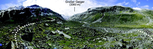
Figure 1. One hundred and eighty degree panorama image of the lower part of the proglacial zone at the Obersulzbachkees landsystem with the summit of the Großer Geiger in the background. The moraine ridge at the margins marks the advance of the Obersulzbachkees in response to the cooler period of the 1920s with the maximum reached ca. 1927 (CitationSlupetzky, 1986). The terrain is impressed by a typical glacial trough morphology with an up to 350 m wide trough bottom delimited by steep rock walls. In the direction of view, a distinct bedrock step of ca. 130 m builds the transition to the present day glacier areas (view to south, 26.07.2011).
Data from surrounding climate stations (Krimml and Sonnblick summit) are used to describe the long-term climatic situation because the meteorological monitoring of the valley itself started in 2008. Mean annual air temperature and precipitation range from 5.8°C and 1154 mm in Krimml (Location: Salzach Valley; 47°14' N, 12°11' E; 1000 m a.s.l.; distance ca. 15 km north-west) to -5.5°C and 1673 mm at the Sonnblick Observatory (Location: 47°3' N, 12°57' E; 3105 m a.s.l., distance ca. 50 km east) and indicate continental climate conditions (data provided by the Central Institute for Meteorology and Geodynamics 2011). The vegetation cover is characterized by alpine meadows, turfs and dwarf shrubs showing two successional stages (see vegetation cover map). A ‘pioneer stage’ with alpine species on surfaces exposed within the last 55 years and a ‘turf stage’ starting at surface ages of around 110 years with a mixture of turf, dwarf shrub and tall herb species (CitationBecker & Dierschke, 2005). Surveys of glacier length changes had begun in the late nineteenth century (1891) but were incomplete until 1923 (CitationPatzelt, 1972). Since then have been repeated annually. First precise cartographic surveys were carried out by Richter in 1880 and 1882 (CitationRichter, 1883), followed in 1904 by Rudel (CitationRudel, 1911) and 1939 by CitationPillewitzer (1940). These maps and a literature review (e.g. CitationPatzelt, 1972, Citation1973; CitationSlupetzky, 1986) delivered a first chronology of post ‘Little Ice Age’ deglaciation. A frontal retreat of more than 1.5 km has been observed in the last 60 years with an average annual retreat of ca. 26 ma−1 and since around the year 2000, the former valley glacier has been dissected into several single glacier tongues (see geomorphological map).
3.2. Pasterze landsystem
The Pasterze landsystem is situated in the north-western part of the province of Carinthia in the territory of the National Park Hohe Tauern (see geographical overview map). Located in the uppermost part of Möll Valley at the foot of Austria's highest peak, the Großglockner (3798 m a.s.l.), the Pasterze is the longest glacier in Austria and the eastern Alps and the source region of the Möll river that drains towards the south into the Drava drainage network. The mapping area extends from ca. 47°3'18,71” to 47°7'30,35” N and from ca. 12°39'26,36 to 12°45'35,58” E with maximum dimensions of ca. 7.6 km in latitude and ca. 7.5 km in longitude. This results in a basin area of 39.7 km2 (33.7 km2 hydrological drainage area) with a relative relief of 1736 m ranging from 2062 m to 3798 m a.s.l. Bedrock exposures are composed of metamorphic Mesozoic rocks mainly of the Glockner nappe (CitationHöck & Pestal, 1994). An arch-shaped area that ranges from the south-west to the eastern valley slope is built up of prasinite and amphibolite (see geological overview map). These are partly embedded with calcareous mica-schist which is also the dominant lithology in the north-east. The north-western crests are made of gneiss and mica-schist of a scale zone interbedded between the Venediger and the Glockner nappe. Differences in rock mass strength have led to an asymmetrical valley morphology with steeper and rugged slopes of prasinite and amphibolite which are considered to be more resistant to glacial erosion as compared to the mica-schist that forms more gently inclined and smoother slopes (). The varying resistance to glacial erosion is also reflected in lower summits altitudes on the left-hand valley side (e.g. Fuscher-Kar-Kopf with 3331 m a.s.l.) compared to the right-hand side with the Großglockner peak (3798 m a.s.l.). In those areas where mica-schist is embedded in amphibolite and prasinite, the latter ones most often form distinct steps and edges. The hypsometry of the study area shows a bimodal distribution with main peaks at elevations ranging from 2800 to 3200 m a.s.l. and a secondary peak at altitudes between 2100 and 2400 m a.s.l. and both are characterized by large contributions of gently inclined areas with slope gradients less than 15° (). These are considered to be the accumulation area and the tongue of the Pasterze which are connected by the massive ice fall of the ‘Hufeisenbruch’ (see geomorphological map). The median elevation of the study site is located at 2841m a.s.l.
Figure 2. One hundred and eighty degree panorama image of the Pasterze landsystem with the summits of the Großglockner, Johannisberg and the Fuscher-Kar-Kopf in the background and Pasterze glacier with a subsequent sandur in the centre (view to north-west, 02.08.2011).
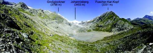
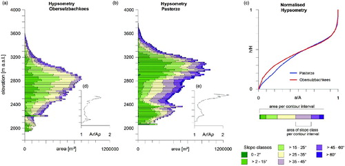
Figure 3. Hypsometry of the Obersulzbachkees (a) and the Pasterze Glacier (b) landsystem. The real surface area of classified slope gradients is given in colours according to the supplementary slope maps and the sum of all slope classes per unit contour interval represents the real surface area of the contour interval. Plots d and e show the ratio between the real surface area (Ar) and planimetric area (i.e. horizontally projected, Ap) per unit contour interval and illustrate the importance of real surface area calculations. A comparison of both landsystems by normalized hypsometric curves of the real surface area is given in addition (c). See text for additional descriptions.
With a mean annual air temperature of 1.6°C and 909 mm of precipitation measured in close vicinity of the study site near the Margaritze reservoir (47°4'16.73” N, 12°45'54.45” E; 2070 m a.s.l.; see geomorphological map), the landsystem is characterized by continental climate conditions (data provided by the Verbund AG, unpublished). A reservoir was constructed in the early 1950s and is an important Austrian hydropower site. Alpine meadows and dwarf shrubs characterize the vegetation and occur continuously, mainly outside the ‘Little Ice Age’ glacier terminus (see vegetation cover map & ). Some sparse patches of pioneer species (e.g. Saxifrage, Cerastium and Gypsophila) are found near the catchment outlet and in the glacier forefield (CitationGewolf, 2011a, Citation2011b). CitationSchlagintweit and Schlagintweit (1850) produced a detailed cartographic representation of the Pasterze only a few years before the ‘Little Ice Age’ maximum extent was reached ca. 1852 (CitationNicolussi & Patzelt, 2001). In 1879, Seeland began measurements of glacier length changes (Seeland, 1880) and more than 120 observations have been carried out since then. A nearly continuous retreat since the LIA has been measured and very short periods of stability and the absence of substantial advances in response to the cooler periods of the 1890s, 1920s and 1970s, where numerous glaciers in Austria advanced, have been reported (e.g. CitationPaschinger, 1969; CitationWakonigg, 1991; CitationWakonigg & Lieb, 1996; CitationZuo & Oerlemans, 1997). An average annual retreat of ca. 16 ma−1 has been measured in the last six decades resulting in a cumulated frontal retreat of ca. 1 km.
4. Results and discussion
4.1. Obersulzbachkees landsystem
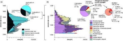
4.1.1. Landsystem analysis: bedrock topography, total sediment coverage, glaciation and hydrological drainage pattern
Bedrock covers ca. 9.47 km2 (ca. 34%, ) of the area mapped and is found in the crest regions, prior to and besides the glaciers with polished and plucked surfaces (, in the vicinity of the Kürsinger Hütte and in the central valley floor where a pronounced bedrock ridge melted out in the early twentieth century. In 2009, ca. 13.5 km2 (48%) of the landsystem were glacierized and since around 1998, the receding Obersulzbachkees has exposed a natural bedrock basin and a proglacial lake has formed (. The lake is a significant sink that decouples large upstream areas of the landsystem with respect to coarse-grained sediment transfer and bathymetry surveys carried out in 2009 yielded a volume of > 2 Mio. m3 and an area of ca. 95000 m2 (CitationKum, 2011; data provided by the Hydrographical Service, Regional government office of the Land Salzburg). In some areas of pronounced supraglacial debris cover, the precise determination of glacier margins was difficult and indicators such as ponors were used to delineate the extent of glacier ice buried by debris. The hydrological pattern is dominated by glacier fed meltwater streams and some intermittent streams which are mainly active during snowmelt or rainfall events. Sediment storages, including supraglacial debris, cover ca. 5.75 km2 (20%, ) of the area. The limit of the LIA glacier advance marks the modern drift line and the area beyond is dominated by blockfield deposits, talus and scree slopes. However, not all deposits within the LIA limit are glacigenic in origin because drift is remobilized by debris flows, avalanches and along the streams. With respect to the concept of paraglacial sedimentation, these deposits can be denoted as ‘paraglacial’.
Figure 4. Quantitative analyses and hypsometric distribution of glaciers, bedrock and sediment storage types at the Obersulzbachkees landsystem given in two levels of detail (LOD). LOD 1 provides a general overview of bedrock exposures, debris covered and clean ice glacier areas and total sediment coverage at the landsystem scale (plot a). LOD 2 depicts the total sediment coverage of LOD 1 in detail and gives the absolute coverage of sediment storages types and their relative contributions to the landsystem area covered by sediment (plot b). The coverage of storage types at the landsystem scale is additionally marked in brackets. See text for additional descriptions.
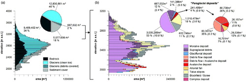
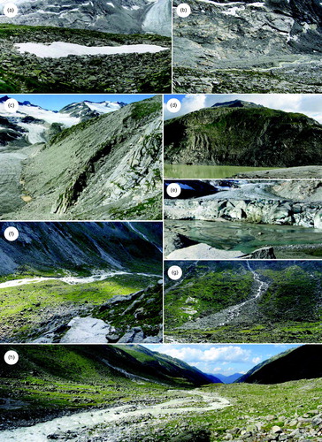
Figure 5. (a) Partly snow covered block field in the vicinity of the Kürsinger Hütte (view to south, 16.08.2009); (b) meltwater channel eroding an esker with large boulders dumped on top in the forefield area of the Venediger and Sulzbachkees (view to south, 16.08.2009); (c) paraglacial reworking and till slope modification at the Venedigerkees (view to south-west, 15.08.2009); (d) the proglacial lake in front of the Obersulzbachkees with a till slope incised by debris flows (view to north, 17.08.2009); (e) glacifluvial outwash sands at an ice proximal location of the Obersulzbachkees (view to south, 17.08.2009); (f) the western slope of the main valley with the Obersulzbach stream, moraine deposits in the valley floor are completely vegetated and active reworking by debris flows, avalanches and linear erosion along the tributaries is indicated by fresh deposit surfaces on the slope, sediment is transferred into the valley floor but hillslope-channel coupling is not observed (view to west, 18.08.2009); (g) gully incised till slope with subsequent coalescing debris cones (view to south-west, 18.08.2009); (h) lower part of the main valley floor with the Obersulzbach stream being the dominant path of sediment output, note the vegetated and stable channel banks (view to north-east, 18.08.2009).
4.1.2. Spatial distribution and activity of sediment storage types
Moraine deposits
All landforms produced by glacial deposition are summarized as moraine deposits that cover ca. 3 km2 (ca. 10.8%) of the landsystem and, with a contribution of 53% to the total sediment coverage, are the dominant deposit type (). Till is predominantly composed of blocky, coarse-grained diamictons with sandy to gravelly matrices. The deposits are generally thin in the vicinity of bedrock outcrops at the central valley floor and stripes of large boulders are found ( & h) which originate from a former supraglacial debris cover described by CitationRichter (1883) and CitationRudel (1911). Sediment thickness increases to both sides of the main valley and several lateral and terminal moraine ridges are clearly visible. The outermost moraine ridge represents the ‘Little Ice Age’ maximum extent and is observed all over the landsystem. In some locations, the LIA ridge is detached and sparse evidence of degradation is found (e.g. in the vicinity of the Sonntagskees). This is hard for us to explain because many studies found that moraine ridge degradation occurs within a few decades (summarized e.g. in CitationBallantyne, 2002). It could be that these detached ridges are less susceptible to debris flow activity because of (i) the local hydrological controls with little water supply from upslope areas and (ii) the sediment properties with many boulders and very few fine sediments. However, both the sediment properties and the hydrological controls are considered to be important to trigger debris flows (CitationCurry, 2000). Within the glacier forefield some smaller moraine ridges mark post LIA advances or stationary conditions during the wet and cooler periods of the 1890s and the late 1920s.
Vegetation cover reaches approximately as far as the 1969 glacier terminus at the main through (see vegetation map) and indicates stabilized surfaces. For example, a former area of gully incision at the north-eastern limit of the Sonntagskees LIA moraine ridge is completely vegetated and inactive today. Recent geomorphic activity of moraine deposits in the landsystem area downstream of the proglacial lake is restricted to a few debris flow gullies at the western slope and the main meltwater channel of the Sonntagskees. In contrast, steep drift-mantled slopes in ice marginal positions are unstable and incised by debris flows that often produce a complex micro-topography of gullies (e.g. at the Venedigerkees, . During fieldwork in April 2010, for example, numerous smaller debris flows were observed during a warm and sunny day suggesting that snowmelt is a significant trigger (hydrological control). Furthermore, the stability of those drift-mantled slopes is greatly influenced by glacial thinning and surface lowering and this leads to proceeding degradation of moraine ridges and deposits. In all locations, the number of gullies were counted to calculate the gully density (i.e. number of gullies per kilometre of slope) that (i) gives a measure of much of the original slope has been destroyed and (ii) enables comparisons between different slopes (CitationCurry, 2000). Because slope length is less than one kilometre in some locations, for example, in the vicinity of the proglacial lake, we give a modified gully density that is the number of gullies per 100 m of slope. Starting at the western slope of the main valley and along the slope north-west of the lake to the slope north of the Venedigerkees, the gully density increases from 0.6 to 3 and to 3.67 with decreasing distance to the glacier. Relatively ‘young’ surfaces that have been exposed within the last five decades are more vulnerable to mobilization and characterized by a higher degree of activity indicated by fresh drift surfaces and intensive gullying.
Supraglacial debris
Supraglacial debris mainly covers the glaciers at the foot of steep rock walls and downstream of prolonged ridges or crests and is supplied by mechanical weathering and subsequent rock fall. The potential source areas are mostly located ≥ 2500 m a.s.l. and facing towards north where, slope destabilization caused by permafrost warming or degradation could be assumed. Several fresh and larger deposits were found during field mapping and it is supposed that the amount of debris delivered onto the glacier surface ranges from single blocks to larger unique rock fall events. Another potential source of supraglacial debris is the melt out of englacial till due to accelerated glacial retreat and ablation (CitationVere & Benn, 1989). In total, ca. 2% of the glacier surface is covered by debris ranging from aggregated single clasts to continuous blankets (). The thickest debris cover is found at the lower limit of the Obersulzbachkees that has significantly reduced glacial lowering and consequently caused a relatively steep glacier margin.
Glacifluvial deposits
Glacifluvial deposits cover ca. 141,400 m2 of the study area and occur as fine-grained glacial outwash sands, former subglacial deposits and rounded clasts and pebbles (). Outwash sands are found at the northern margin of the Venedigerkees and at the lower limit of the Obersulzbachkees where a delta propagates into the proglacial lake (. An esker is located in front of the Sulzbach- and Venedigerkees with some large boulders of former supraglacial debris dumped on top (. Katabatic winds and deflation of fine particles (silt and sand) were observed when sediment was dry. Rounded and unweathered clasts and pebbles are found alongside the main melt water channels (. In the lower part of the landsystem, palaeo channels and smaller terrace steps are observed at the eastern bank of the stream with pebbles and clasts showing a sparse vegetation and lichen cover as compared to the surrounding till. This area was considerably modified during a single but heavy flood event in 1987 where discharge of up to119 m3/s was measured at a gauge located ca. 12 km further downstream at the outlet of the valley (pers. comm. H. Wiesenegger, Hydrographical Service, 2010). As a consequence, an artificial dam was built to stabilize the eastern bank and to protect the cable car valley station.
Alluvial fans, avalanche and debris flow deposits and complex storage
Till is reworked by slope and glacifluvial processes and the resulting accumulations cover an area of ca. 241,500 m2 and represent 4% of the total sediment coverage and ca. 0.9% of the entire landsystem, respectively (). At the western slope of the main valley, remobilized till is temporarily stored in (i) debris flow deposits at the base of gullies dissecting moraine deposits, (ii) thinly layered avalanche deposits, and (iii) in an alluvial fan formed by the Sonntagskees meltwater stream. All deposits are clearly visible due to unweathered sediment surfaces ( & g). Vegetated avalanche and debris flow deposits with some recent activity at the apex are found at the north-eastern limit of the mapping area. At the eastern slope, polygenetic deposits resulting from a combination of glacial dumping, rock fall and avalanche activity are found which are mainly unvegetated and sediment is remobilized by debris flows and linear erosion below bedrock gullies. Coalescing debris flow deposits dominate the north-western shoreline of the lake ( and ice marginal locations of the Venedigerkees at the base of the gully dissected ‘Little Ice Age’ lateral moraine ridge (.
Talus slopes, blockfield deposits and scree slopes
In this study, rock fall accumulations at the foot of frost-susceptible rock are attributed to talus slopes whereas the in-situ mechanical weathering of gently inclined bedrock areas results in the accumulation of scree and blockfields. Our distinction between blockfield and scree is based on grain size and scree is generally a finer-grained weathering product as compared to blockfields. In total, these deposits cover ca. 6% of the entire landsystem () and are found beyond the historical glacier limit. Talus slopes are generally unvegetated, partly lichen covered at the lower limits and the upper parts mostly appear to be active. However, it is difficult to distinguish between single block fall and larger unique rock fall events. The blockfields are typically composed of unvegetated boulder-rich rubble and large plates of various thickness. They are often found in elongated and shallow depressions framed by bedrock in the southwestern vicinity of the Kürsinger Hütte and a sparse lichen cover could indicate a longer duration of snow cover (. Scree is mostly vegetated and found at the north-western limit of mapping area and north of Kürsinger Hütte where some tongue shaped lobes suggest bound solifluction.
4.1.3. Process (de)coupling and the sediment transport system
Four subsystems are delineated with respect to process (de)coupling and the sediment transport system: (i) the slope subsystem, (ii) the glacier subsystem, (iii) the glacier forefield subsystem upstream of the proglacial lake, and (iv) the glacier forefield subsystem downstream of the proglacial lake ( & b).
| 1. | The Slope subsystem beyond the ‘Little Ice Age’ limit covers 26% of the landsystem. Sediment is produced by mechanical weathering of bedrock and in some circumglacial locations transferred to the subsystem glacier by rock fall. Evidence of sediment output from the detritus landform assemblage is rare and subsystem coupling seems to be mainly restricted to circumglacial rock faces. | ||||
| 2. | The Glacier subsystem covers the majority of the landsystem (48%) and includes all glaciers even though they are dissected today. Their combination into one subsystem has been done with respect to the spatial extent and the expansion of the glacier forefield. At the time of the ‘Little Ice Age’ maximum extent, the Sonntagskees was connected with Obersulzbachkees and, with proceeding glacial retreat, the glacier forefield has expanded in two directions following both the receding glaciers. Glacial erosion has produced large amounts of sediment currently stored inside the landsystem and provides the majority of sediment input into both glacier forefield subsystems. Further subsystem coupling is indicated by supraglacial debris that is received from circumglacial rock faces (slope subsystem) and from unstable drift slopes in some ice marginal locations. | ||||
| 3. | The glacier forefield subsystem upstream of the proglacial lake occupies 14% of the landsystem and paraglacial reworking and slope form modification by debris flows seem to be the dominant evolutionary factor of unstable glacial deposits in ice marginal and proximal locations (gully density of 3–3.67). Geomorphic activity at the northern margin of the Venedigerkees is strongly controlled by channelized water delivery from upslope areas and slope destabilization caused by glacial melting and thinning. The channel pattern in front of the Venediger and Sulzbachkees is highly variable and collapsing channel banks indicate glacifluvial erosion and transport and glacial outwash sands are deposited in, and in front of, the proglacial lake. In general, this subsystem is the most active one regarding sediment reworking and redeposition. However, the proglacial lake traps all coarse and probably large amounts of suspended sediment and thus, the subsystem is partly closed. | ||||
| 4. | The glacier forefield subsystem downstream of the proglacial lake includes the main through and the forefield area of the Sonntagskees. It represents 12% of the landsystem and is dominated by large areas of vegetated and stable glacial deposits. The Sonntagskees proglacial zone is mainly ice-scoured bedrock and considered to be an avalanche starting zone and an important flow producing area during rainfall events with a rapidly channelized water supply that is clearly linked with the location of gullies at the western slope of the main valley (modified gully density of 0.6). A similar situation and spatial pattern of sediment storage activity is found on the opposite slope. However, sediment is reworked on both slopes and partly transferred onto the valley floor but currently not delivered to the channel. The Obersulzbach stream is generally stable downstream of the lake with vegetated and boulder armoured banks. Recent channel bank erosion was only sporadically found in the lower reach.
Figure 6. Conceptual sediment cascade model of the Obersulzbachkees landsystem (a), please note that the number of processes within the sediment cascade has been reduced to the most dominant. Location and dimension of subsystems with the spatial distribution of sediment storage units classified according to the function within the sediment cascade (b). The relative importance of these units in the ongoing sediment budget analysis was estimated qualitatively and the most important zones are numbered in both plots. See text for additional descriptions. 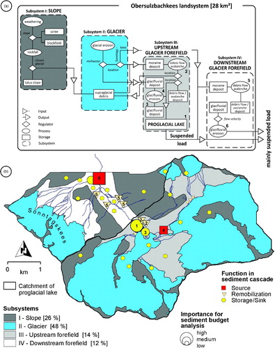 | ||||
Six key zones are identified that are of great importance in the ongoing sediment budget analysis (. With respect to of the overall sediment discharge from the Obersulzbachkees landsystem, the meltwater stream is the dominant path of sediment output. The glacifluvial transport system is interrupted by the proglacial lake (1) that decouples ca. 18.7 km2 (67%) of the landsystem and leads to reduced connectivity between glacial sediment production and downstream sediment fluxes. Therefore, the lake plays a key role in the sediment transport system. The quantification of sediment input into the lake from the glacier, the surrounding drift-mantled slopes (2) and ice proximal locations (3 and 4) and the determination of the efficiency of suspended sediment trapping will contribute to both a quantitative statement of the lake's impact on suspended load and speculation on its lifetime. The hillslopes downstream of the lake (5) are decoupled from the meltwater channel even though active slope processes are observed. Hence, paraglacial slope adjustment plays a negligible role for sediment output at present and the exploitation of bed load sources appears to be restricted to the erosion of channel banks and in-channel storages respectively. The spatial and temporal intensity of paraglacial reworking at different terrain ages (distance from the glacier) within the glacier forefield is of great importance in this study. The amount of sediment available for glacifluvial erosion and transport will change considerably once sediment from the slopes (5) is to be delivered to channel and this in turn could have consequences for the lower channel reach (6). From the current observation it is hypothesized, that the majority of sediment output from the Obersulzbachkees landsystem is suspended load.
4.2. Pasterze landsystem
4.2.1. Landsystem analysis: bedrock topography, total sediment coverage, glaciation and hydrological drainage pattern
Glaciers covered ca. 21.38 km2 (ca. 54%, ) of the Pasterze landsystem in 2009 and ca. 80% fall upon the Pasterze, a typical alpine valley glacier with a tongue of > 4 km length. A distinct attribute of Pasterze Glacier is an extensive supraglacial debris cover (see geomorphological map). The dense glaciation of the north-eastern valley side is in contrast to the opposite slope being ice free except of the Wasserfallwinkel. Bedrock covers 33% (ca. 12.9 km2, ) of the area mapped with cirques and rugged crests in areas of prasinite and amphibolite and plucked and polished bedrock surfaces prior to and besides the glaciers. The areas of mica-schist are more gently inclined with smooth and platy surfaces which are locally called ‘Bratschen’. The hydrological pattern is mainly characterized by meltwater streams due to the relatively high percentage of glaciation. Sediment storage and supraglacial debris are spread over 20% (ca. 5.75 km2, ) of the area and the modern drift limit is marked by the ‘Little Ice Age’ advance. Glacial and glacifluvial deposits and those of reworked till are found within the drift limit and detritus and fine-grained weathering products characterize the sediment coverage beyond the drift limit.
Figure 7. Quantitative landsystem analyses and sediment storage distribution at the Pasterze area given in two levels of detail (LOD 1 & 2, figure structure is equal to ). Additional descriptions are given in the text.
4.2.2. Spatial distribution and activity of sediment storage types
Moraine deposits
Moraine deposits cover ca. 3 km2 (ca. 7.6%, ) of the landsystem and are widely spread within the LIA limit. Till is composed of coarse-grained diamictons with sandy to gravelly matrices and mainly free of vegetation except very few patches at the lower forefield area where surfaces have been exposed for more than five decades. The LIA limit, achieved at the Pasterze ca. 1852 (CitationNicolussi & Patzelt, 2001), is indicated by a sharp contrast in vegetation cover ( and sporadically traced by lateral moraine ridges, for example, in the vicinity of the Wasserfallwinkel ( and the lower forefield area (. Recent activity is observed particularly at north-eastern ice marginal locations where debris flows and avalanches incise the LIA moraine ridge and the drift-mantled slope (gully density of 1.2). Till is already exhausted in many upper parts of the slope and bedrock is stripped. Several smaller terminal moraine ridges are found immediately in front of the Pasterze probably dating back to the mid 1990s and the ice proximal area is characterized by a chaotic pattern of irregular hummocks and hollows formed by melting debris covered ice bodies (. This assemblage has been reported to be typical for receding glacier margins (CitationHubbard & Glasser, 2005). Small till slides and slumps that expose underlying glacier ice are often observed and provide a rough measure to delineate the spatial extent of ice cored moraine deposits. At the eastern margin of the Pasterze, field evidence of debris covered ice is rare but ice cores are assumed. During field mapping it has been observed that fine and dry sediment in ice proximal locations is susceptible to deflation. The till cover found at the south-western slope of the lower forefield area is remarkably thicker when compared to the opposite slope due to dumped supraglacial debris. However, the deposits seem to be generally stable and a gully density of 0.5 is calculated. The steeper forefield areas of the tributary glaciers are rarely covered by till and it is assumed that most of the deposits have already been exhausted. Some moraine deposits are preserved at flatter areas in front of the Schwerteckkees and the Kellersbergkees.
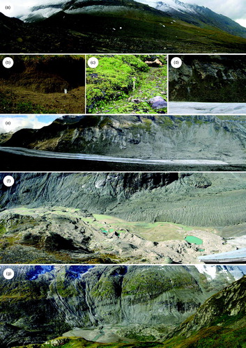
Figure 8. (a) The ‘Little Ice Age’ moraine ridge at the Wasserfallwinkel (view to east, 11.09.2009); (b) fined grained scree with a high sand content originating from the mechanical breakdown of calcareous mica-schist at the lower limit of the Gamsgrube (12.09.2009); (c) scree and bound solifluction in the vicinity of the Hofmanns Hütte (11.09.2009); (d) ice marginal reworking of moraine deposits exposing former till covered bedrock (view to north-east, 13.09.2009); (e) smooth and platy bedrock outcrops of calcareous mica-schist (so called ‘Bratschen’) at the orographic left slope of the Pasterze with intensive reworking of moraine deposits, the maximum ‘Little Ice Age’ extent of the Pasterze is indicated by the intersected vegetation cover (view to north-east, 13.09.2009); (f) proximal forefield area including the lower limit of the Pasterze with the pronounced supraglacial debris cover, the central part shows glacial outwash sands limited by hummocky terrain with melting dead ice bodies and kettle holes, note the change in water colour (view to south-west, 22.09.2009); (g) debris flow and avalanche tracks incising the lateral moraine and the till mantled slope in the lower forefield area, the intersected vegetation cover indicates the LIA limit (view to south-west, 10.09.2009).
Supraglacial debris
Thirty-one percent of the total sediment coverage is supraglacial debris of which the majority covers the right part of the Pasterze (). CitationKellerer-Pirklbauer et al. (2008) investigated the spatio-temporal evolution, the debris characteristics and the transport system of the supraglacial debris cover. They found a consistent increase in sediment thickness from the central part towards the glacier margins and a longitudinal increase towards the glacier terminus. In 2002, more than 180000 m3 of sediment covered the glacier with a mean sediment thickness of ca. 15 cm (CitationKellerer-Pirklbauer et al., 2008). The debris cover explicitly reduces ablation and leads to minor retreat and shrinkage rates when compared to the clean ice part. Based on multi-temporal topographic map interpretation, a significant increase of debris cover over four decades was identified (1964–2002). The authors explained this through a combination of (i) increased bedrock exposure due to continuous glacial retreat, (ii) sediment supply by rock fall accelerated by permafrost warming and degradation, (iii) sediment input due to the exhaustion of temporal storage, and (iv) melt out of englacial debris and supraglacial debris supply from tributary glaciers. The debris cover is predominantly composed of prasinite and calcareous mica-schist due to the lithology of the dominant source areas (CitationKellerer-Pirklbauer et al., 2008). Supraglacial debris at the opposite margin of the Pasterze originates from paraglacial reworking of till ( & e) and in some locations from rock fall activity (e.g. in the vicinity of the Hufeisenbruch or the Oberwalderhütte; CitationKellerer-Pirklbauer et al., 2012).
Glacifluvial deposits
Sediment storages of the glacifluvial domain are (i) outwash sands found in front of the Wasserfallwinkel and the Pasterze (, (ii) flat topped Kame terraces of rounded clasts, gravel and sand following the limits of hummocky moraine deposits in ice proximal locations, and (iii) rounded clasts along former meltwater channels separated from the present day drainage pattern due to glacial retreat. Altogether, glacifluvial storage covers less than 1% of the landsystem (). The channel pattern in front of the Pasterze is highly variable and changes on a weekly to seasonal scale, with some kettle holes found. During the ablation season, the deposits are often flooded in the afternoon at peak discharge. An almost plain and circular sandur of ca. 120000 m2 and more than 400 m length is located further downstream (. It was a proglacial lake exposed by continuous glacial retreat that has been filled by glacifluvial sedimentation. A small gravel dominated delta that is currently buried by fine-grained sediment marks the eastern limit of the sandur and as is typical for sandar, grain sizes significantly decrease to silt and clay towards the margins. A specific seasonal pattern of erosion and deposition that is determined by the glacial discharge regime has been described by CitationKrainer and Poscher (1992). During high flow conditions in the summer, the meltwater is dammed up to a very shallow lake flooding the sandur (backwater situation). This leads to reduced flow velocities and consequently to the deposition of large amounts of suspended sediment (in 1992: ca. 50–60%, CitationKrainer & Poscher, 1992). With decreasing discharge, the backwater situation disappears and the sandur is partially eroded. The channel gradient between the glacier snout and the catchment outlet is very low and indicates reduced stream power and transport capacity of the meltwater stream; evidence of bed load transport has not been found at the catchment outlet. The spatial and temporal variability of glacifluvial erosion and deposition found at the Pasterze landsystem has also been reported from other glacierized basins (e.g. CitationCarrivick & Rushmer, 2009).
Alluvial fans, avalanche and debris flow deposits
Reworked till is stored in debris flow, avalanche and alluvial deposits with fresh unweathered surfaces and these sediment storages represent 4% (ca. 337100 m2) of the total sediment coverage and ca. 0.9% of the entire landsystem respectively (). Most of the activity is found at the north-eastern ice marginal slope where moraine deposits are unstable and prone to remobilization. Both the LIA moraine ridge and subsequent glacial deposits are incised by debris flows that have produced a gully dissected topography at the upper part of the slope (gully density 1.2) and coalescing debris cones at the foot of the slope that are mixed with recent moraine deposits and partly cover the margin of the Pasterze. In some locations, the debris flow accumulations are limited by recently deposited hummocky till in the direction of the glacier margin; the lower limit of the debris flow deposits is considered to be a former ice margin. Further reworking of in-situ deposited till and already reworked drift could lead to the development of ‘multi-level’ deposits. However, sediment from these ice marginal locations is currently not transferred to the glacifluvial domain. A significantly reduced degree of activity is found in the lower forefield area of the Pasterze and till remobilization is limited to a few active debris flow, avalanche and meltwater paths (gully density 0.5). A former meltwater channel had led to the development of an alluvial fan that propagated into the former proglacial lake at the northern shoreline. This channel was redirected in the 1970s due to glacial retreat and the lower limit of the fan has been buried by glacifluvial sedimentation.
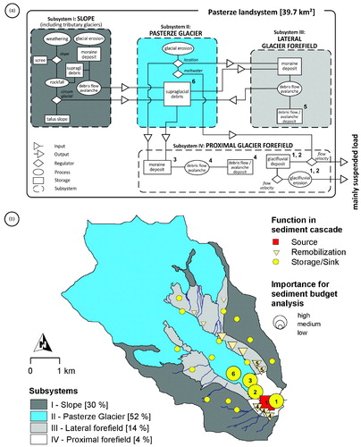
Figure 9. Conceptual sediment cascade model (a) and subsystem map (b) of the Pasterze landsystem (figure structure is equal to , please note that the spatial coverage of the Pasterze Glacier subsystem differs from the glacial coverage at the landsystem scale () because the tributary glaciers are incorporated in the subsystem slope). See text for additional descriptions.
Talus slopes, rock fall and aeolian deposits and scree slopes
Talus slopes cover ca. 2.3% () of the catchment and are found at the foot of rock walls, for example, at the Mittlere Burgstall, a prominent bedrock ridge south-west of the Oberwalderhütte, where numerous rock fall events have been observed in the recent past (CitationKellerer-Pirklbauer et al., 2012). A larger and mainly vegetated rock fall deposit is found close to Hofmanns Hütte and the large boulders are in sharp contrast to the surrounding area. Scree has accumulated at the north-western slope beyond the modern drift line that is completely vegetated today with evidence of bound solifluction partly observed (. At the Gamsgrube, a cirque at the foot the Fuscher-Kar-Kopf, sand dunes have developed and sands were probably deflated from the vicinity of the Pasterze during inter and intra glacial periods when the surface was free of vegetation.
4.2.3. Process (de)coupling and sediment transport system
The Pasterze landsystem is classified into (i) the slope subsystem, (ii) the Pasterze Glacier subsystem, (iii) the glacier forefield in ice lateral locations subsystem, and (iv) the proximal glacier forefield subsystem ().
| 1. | The Slope subsystem includes the area beyond the ‘Little Ice Age’ limit of the Pasterze, the circumglacial bedrock and the tributary glaciers which were not connected with the Pasterze during LIA times. It covers 30% of the landsystem ( and is characterized by a contrast in lithology and morphology. Sediment production by weathering and subsequent transfer from circumglacial rock faces to the glacial subsystem is indicated by the pronounced supraglacial debris cover of the Pasterze. CitationKellerer-Pirklbauer et al. (2008) also identified sediment supply from the tributary glaciers and from the moraine deposits in front of the Pasterze. At present, there is little evidence of geomorphic activity of the glacial deposits that have been preserved in front of the Schwerteckkees and Kellersbergkees. At the north-eastern valley slope, clastic sediment output is limited to very few channels and the majority of sediment is stored in the landform assemblage of talus slopes and vegetated scree (. | ||||
| 2. | The Pasterze glacier subsystem occupies 52% of the landsystem. This is slightly lower (2%) than the total glacier coverage at the landsystem scale because the tributary glaciers are not incorporated. The glacial subsystem provides the majority of sediment input to the adjacent subsystems and the receding glacier margins cause destabilization of ice marginal drift slopes mainly in the lateral forefield area. Supraglacial debris found at both margins indicates subsystem coupling and the majority of supraglacial debris covers the right part of the Pasterze (. The sediment cover significantly reduces ablation and influences the intensity and spatial pattern of glacial retreat. It has also caused a remarkably thicker till cover of the south-western slope in the proximal glacier forefield when compared to the opposite slope. | ||||
| 3. | The lateral glacier forefield subsystem represents 14% of the landsystem and the north-eastern slope is particularly active with respect to sediment remobilization. However, the gully density of 1.2 is considered to be relatively low because the prerequisite for intensive gully incision, slope gradient > 30° (CitationCurry, 2000), is found all over the initial drift slope. Bedrock is stripped in many upper parts of the slope and it is suggested that much of the initial drift has already been exhausted. This could possibly explain the reduced number of gullies observed today. Till is redeposited at the foot slopes and partly accumulated on the glacier surface coupling the gravitational process domain on the slopes with the glacial process domain on the valley floor (. Sediment from this landsystem area is currently not supplied to the main meltwater channel. | ||||
| 4. | The proximal glacier forefield subsystem accounts for 4% of the landsystem ( and active slope processes are mainly found at the south-western slope where drift is reworked along the Schwerteckkees meltwater streams (gully density 0.5). The deposits partly propagate onto the glacifluvial valley floor storages but sediment is not delivered to the main meltwater channel at present (. Melting of debris covered ice in proximal locations of the Pasterze leads to rapidly changing surface conditions but little sediment evacuation is assumed. The subsequent sandur is characterized by a specific seasonal pattern of deposition during high flow conditions (summer) and subsequent erosion at low flow (autumn; CitationKrainer & Poscher, 1992). Thus, the function of the sandur within the sediment cascade shifts from a temporal sink to a temporal source through the course of the year (. | ||||
Six key zones are assigned with respect to sediment yield and the ongoing sediment budget analysis at the Pasterze landsystem (. The sandur (1) is the last major landform in a key position within the sediment cascade. The very low channel gradient of the meltwater stream at the sandur (1) and in front of the Pasterze (2) indicates a reduced transport capacity for coarser sediment that is available in ice proximal locations (3) and permanently supplied by the dumping of supraglacial debris (6). Active hillslopes in both the proximal glacier forefield (4) and in the lateral glacier forefield (5) are indeed currently decoupled from the glacifluvial transport system, but rates of paraglacial reworking measured in varying distance to the glacier provide insights into the state and the importance of paraglacial adjustment at different terrain ages within the glacier forefield. Quantitative statements of the sediment availability in the proglacial zone (1, 2, 3 & 4) become important in the light of expected discharge modifications due to glacier melt accelerated by climate change. At present, sediment output from the Pasterze landsystem is assumed to be suspended load.
5. Conclusions and perspectives
The spatial distribution of sediment storage types and (sub)recent sediment transfer processes has been mapped in the glacier landsystems of the Obersulzbachkees and the Pasterze and displayed in geomorphological maps at 1:10,000 and 1:12500 scale, respectively. The maps enable conclusions on the function of sediment storages within the sediment cascades and the overall activity of the geomorphic systems with respect to process (de)coupling of the sediment transfer systems. The spatial distribution of sediment storage types within the LIA limits and the semi-quantitative criteria of sediment storage activity deliver a record of the historical activity of the glaciers and provide insights into the subsequent paraglacial landform adjustment of the terrain deglaciated since the ‘Little Ice Age’.
Over the last six decades, glaciers have retreated more than 1 km in both landsystems leading to two types of landscape transformation: paraglacial adjustment and primary succession of vegetation both reflecting the influences of past processes on the present day environment. The rapidity of plant colonization indicates both, contemporary stabilized surfaces and the rapid paraglacial adjustment of these surfaces because vegetation succession is a response to stabilization of the ground (CitationMatthews, 1992; CitationMoreau et al., 2008). The vegetation cover increases with increasing distance from the glaciers and thus represents an excellent indicator of paraglacial activity and landform stabilization. The maximum terrain age of the valley floor at the Pasterze is ca. 60 years compared to ca. 110 at the Obersulzbachkees and surfaces at the valley floor being exposed for more than 50 to 60 years appear to be stabilized.
A typical landform assemblage is found in both landsystems with (i) block field, talus and scree slopes beyond the modern drift limit (‘Little Ice Age’ advance), (ii) glacigenic sediments and glacial landforms within the drift limit, (iii) glacifluvial storages in ice proximal locations and along recent and former meltwater channels, and (iv) reworked till temporarily stored in debris flow, avalanche and alluvial deposits at the base of incised moraine ridges, drift-mantled slopes or stream tributaries. Moraine deposits are the dominant sediment storages, followed by the talus slope – scree assemblage beyond the LIA limit and supraglacial debris. At the Pasterze landsystem, the pronounced supraglacial debris cover exceeds the landsystem area covered by talus slopes and scree. Deposits of remobilized till, for example, debris flow deposits, account for ca. 4% of the total sediment cover in both landsystems and paraglacial reworking is the main evolutionary factor for drift-mantled slopes and moraine ridges with decreasing activity and importance with increasing distance from the glaciers. The high degree of sediment storage activity especially in ice marginal locations demonstrates the significance of adjustment processes at the very beginning of deglaciation. We found gully densities per 100 metres of slope length > 1 at these locations and densities < 1 at greater distances from the glaciers, which are determined by channelized water delivery from upslope areas. Although slope processes influence sediment movement in both landsystems, they currently do not affect sediment output because of sediment sinks and decoupled hillslopes. At present, till and coarse debris are stored inside the landsystems and paraglacial adjustment plays a negligible role for sediment output but is of great importance for slope form modification. It is consequently hypothesized that the majority of sediment output from both landsystems is suspended load.
Significant sediment sinks at different filling conditions are developed in both landsystems that have varying influences on sediment yield. A recently developed proglacial lake decouples large areas of the Obersulzbachkees landsystem and reduces the connectivity between glacial sediment production and downstream sediment flux. The exploitation of bed load sources downstream of the lake is limited to channel bed and bank erosion due to decoupled hillslopes. Thus, the Obersulzbachkees is a supply limited landsystem. At the Pasterze landsystem, a former proglacial lake has been completely filled and a sandur has formed that indeed provides downstream connectivity at the expense of a reduced transport capacity for the meltwater stream due to a low channel gradient. The Pasterze landsystem is therefore suggested to be transport limited. Multi-temporal aerial image and orthophoto interpretation showed that the period of lake aggradation at the Pasterze was completed in ca. 20 years. This gives an impression of the rapidity of glacifluvial sedimentation in glacier forefields and provides useful insights into the future development of the proglacial lake at the Obersulzbachkees landsystem. The observations made in both landsystems highlight the control of the proglacial zone on sediment yield and the importance of the topography of the recently deglaciated valley floor. If retreating glaciers expose natural basins that are capable of forming proglacial lakes, sediment flux from glacier forefields will be significantly altered.
Our results are in agreement with findings from other proglacial zones (e.g. CitationCarrivick et al., 2012; CitationCarrivick & Rushmer, 2009; CitationCurry, 2000; CitationCurry et al., 2006; CitationMatthews, 1992; CitationMoreau et al., 2008). CitationCurry et al. (2006) reported from two glacier forefields in the Swiss Alps, that paraglacial slope adjustment operates primary through gully incision and subsequent debris cone formation within a few decades but that the transfer of valley floor paraglacial sediment stores tends to be much slower. Within the proglacial zone of the Ödenwinkelkees, a glacier located ca. 7 kilometres north-west of the Pasterze, CitationCarrivick et al. (2012) quantified contemporary geomorphological activity and sediment transport by means of repeated terrestrial laser scanning. They found that activity decreases in both intensity and areal extent with increasing distance from the glacier and that it becomes progressively confined to the valley floor and thus to the fluvial process domain Citation(Carrivick et al., 2012). These conclusions are consistent with the situation found at the Obersulzbachkees and the Pasterze Glacier landsystem.
Supplemental Material - Map
Download PDF (38 MB)Acknowledgements
This paper and associated maps emanate from an individual project of the University of Salzburg within the collaborative research project SedyMONT (Timescales of Sediment Dynamics, Climate and Topographic Change in Mountain Environments, ESF TOPO-EUROPE programme, cf. http://www.sedymont.sbg.ac.at). We would like express our warmest thanks to Marianna Lingg for help with data digitizing and to the Hydrographical Service (Regional government office of the Land Salzburg, Austria) providing bathymetry data of the Obersulzbachkees proglacial lake. The constructive comments of Oliver Sass, Paolo Paron, Jonathan Carrivick and David Morche improved the final manuscript and corresponding maps. Financial support provided by the Austrian Science Fund (FWF): Projektnummer I 157-N19 is gratefully acknowledged. The geomorphic symbol set used in this study has been compiled by CitationOtto & Dikau (2004) and is freely available at http://www.geomorphology.at.
References
- Ballantyne , C. 2002 . Paraglacial geomorphology . Quaternary Science Reviews , 21 : 1935 – 2017 .
- Becker , T. and Dierschke , H. 2005 . Primary succession on the forefield of the Obersulzbachkees Glacier (Hohe Tauern, Austria): A chronosequence of almost 150 years . Tuexenia , 25 : 111 – 140 .
- Bogen , J. 1989 . Glacial sediment production and development of hydro-electric power in glacierized areas . Annals of Glaciology , 13 : 6 – 11 .
- Carrivick , J. , Geilhausen , M. , Warburton , J. , Dickson , N. , Carver , S. , Brown , L. and Evans , A. 2012 . Spatial distribution and temporal intensity of contemporary geomorphological activity within an alpine mountain catchment . Geomorphology , doi: 10.1016/j.geomorph.2012.03.029
- Carrivick , J. and Rushmer , E. 2009 . Inter- and intra-catchment variations in proglacial geomorphology: An example from Franz Josef Glacier and Fox Glacier, New Zealand . Arctic Antarctic and Alpine Research , 41 : 18 – 36 .
- Church , M. and Ryder , J. 1972 . Paraglacial sedimentation: A consideration of fluvial processes conditioned by glaciation . Geological Society of American Bulletin , 83 : 3059 – 3071 .
- Church , M. and Slaymaker , O. 1989 . Disequilibrium of Holocene sediment yield in glaciated British Columbia . Nature , 337 : 452 – 454 .
- Comelius, H., Frank, W., Fuchs, G., Grundmann, G., Hoke, L., Malecki, G., … Steyrer, H. (1987). Matrei in Osttirol: Geologische Karte der Republik Österreich, ÖK 152 im Maßstab 1:50.000, Nebenkarten (Tektonische Übersicht und Verteilung der Arbeitsgebiete) im Maßstab 1:400.000. Wien: Geologische Bundesanstalt.
- Curry , A. 2000 . Observations on the distribution of paraglacial reworking of glacigenic drift in western Norway . Norsk Geografisk Tidsskrift , 54 : 139 – 147 .
- Curry , A. , Cleasby , V. and Zukowskyj , P. 2006 . Paraglacial response of steep, sediment-mantled slopes to post-'Little Ice Age' glacier recession in the central Swiss Alps . Journal of Quaternary Science , 21 : 211 – 225 .
- Einsele , G. and Hinderer , M. 1997 . Terrestrial sediment yield and the lifetimes of reservoirs, lakes, and larger basins . Geologische Rundschau , 86 : 288 – 310 .
- Gewolf , S. 2011a . “ Das Gletschervorfeld der Pasterze - ein Kleinod mit botanischen Kostbarkeiten ” . In Die Pasterze: Der Gletscher am Großglockner , Edited by: Nationalpark , Hohe Tauern and Oesterreichischer , Alpenverein . 86 – 87 . Salzburg : Verlag Pustet .
- Gewolf , S. 2011b . “ Das Gletschervorfeld der Pasterze - Pioniere und Spezialisten am Rande des Eises ” . In Die Pasterze. Der Gletscher am Großglockner , Edited by: Nationalpark , Hohe Tauern and Oesterreichischer , Alpenverein . 48 – 49 . Salzburg : Verlag Pustet .
- Haeberli , W. , Hoelzle , M. , Paul , F. and Zemp , M. 2007 . Integrated monitoring of mountain glaciers as key indicators of global climate change: The European Alps . Annals of Glaciology , 46 : 150 – 160 .
- Hauenstein , W. 2005 . Hydropower and climate change - a reciprocal relation: Institutional energy issues in Switzerland . Mountain Research and Development , 25 : 321 – 325 .
- Höck , V. and Pestal , G. 1994 . Großglockner: Geologische Karte der Republik Österreich, ÖK 153 im Maßstab 1:50.000, Nebenkarten (Tektonische Übersicht und Verteilung der Arbeitsgebiete) im Maßstab 1:400.000 , Wien : Geologische Bundesanstalt .
- Hoelzle , M. , Chinn , T. , Stumm , T. , Paul , F. , Zemp , M. and Haeberli , W. 2007 . The application of glacier inventory data for estimating past climate change effects on mountain glaciers: A comparison between the European Alps and the Southern Alps of New Zealand . Global and Planetary Change , 56 : 69 – 89 .
- Hubbard , B. and Glasser , N. 2005 . Field techniques in glaciology and glacial geomorphology , Chichester : Wiley-Blackwell .
- Jenness , J. 2004 . Calculating landscape surface area from digital elevation models . Wildlife Society Bulletin , 32 : 829 – 839 .
- Jenness , J. 2011 . DEM Surface Tools . v. 2.1.292. Jenness Enterprises. Retrieved January 9, 2012, from http://www.jennessent.com/arcgis/surface_area.htm
- Karl , F. and Schmidegg , O. 1964 . Hohe Tauern, Großvenedigerbereich. Exkursion 1/1: Stoffbestand, Alter und Tektonik der zentralen Granite und der Schieferhüllgesteine im weiteren Bereich des Großvenedigers . Mitteilungen der Österreichischen Geologischen Gesellschaft, Wien , 57 : 1 – 16 .
- Karl , F. and Schmidegg , O. 1979 . Krimml. Geologische Karte der Republik Österreich, ÖK 151 im Maßstab 1:50.000, Nebenkarten (Tektonische Übersicht und Verteilung der Arbeitsgebiete) im Maßstab 1:400.000 , Wein : Geologische Bundesanstalt .
- Kellerer-Pirklbauer , A. , Lieb , G. , Avian , M. and Carrivick , J. 2012 . Climate change and rock fall events in high mountain areas: munerous and extensvie rock falls in 2007 at Mittlerer Burgstall, Central Austria . Geografiska Annaler: Series A, Physical Geography , 94 : 59 – 78 .
- Kellerer-Pirklbauer , A. , Lieb , G. , Avian , M. and Gspurning , J. 2008 . The response of partially debris-covered valley glaciers to climate change: The example of the Pasterze Glacier (Austria) in the period 1964 to 2006 . Geografiska Annaler Series A , 90 : 269 – 285 .
- Kinzl , H. 1929 . Beiträge zur Geschichte der Gletscherschwankungen in den Ostalpen . Zeitschrift für Gletscherkunde, für Eiszeitenforschung und Geschichte des Klimas , 17 : 66 – 121 .
- Kneisel, C., Lehmkuhl, F., Winkler, S., Tressel, E. and Schröder, H. (Eds.). 1998. Legende für geomorphologische Kartierungen im Hochgebirge. Trierer Geographische Arbeiten, 18. Geographische Gesellschaft Trier, Trier, 24 pp.
- Krainer , K. and Poscher , G. 1992 . Sedimentologische Beobachtungen im Gletschervorfeld der Pasterze (Glocknergruppe, Hohe Tauern) . Carinthia II , 182 : 317 – 343 .
- Kum , G. 2011 . Vermessung Obersulzbachsee: Bericht-Nr. 09/023-B01, DWS Hydro-Ökologie GmbH Wien Unpublished technical report
- Leser , H. and Stäblein , G. 1975 . Geomorphologische Kartierung: Richtlinien zur Herstellung geomorphologischer Karten 1: 25000 , Berlin : Institut für Physische Geographie der freien Universität Berlin .
- Lotz , A. 2006 . “ EU Community Initiative INTERREG III B Alpine Space ” . In Alpine Habitat Diversity - HABITALP - Project Report 2002-2006 , Nationalpark Berchtesgaden .
- Matthews , J. 1992 . The ecology of recently deglaciated terrain: A geo-ecological approach to glacier forelands and primary succession , Cambridge : Cambridge University Press .
- Moreau , M. , Mercier , D. and Rousel , D. L. E. 2008 . Impacts of recent paraglacial dynamics on plant colonization: A case study on Midtre Lovenbreen foreland, Spitsbergen (79 degrees N) . Geomorphology , 95 : 48 – 60 .
- Nicolussi , K. and Patzelt , G. 2001 . Untersuchungen zur holozänen Gletscherentwicklung von Pasterze und Gepatschferner (Ostalpen) . Zeitschrift für Gletscherkunde und Glazialgeologie , 36 : 1 – 87 .
- Otto , J. and Dikau , R. 2004 . Geomorphic system analysis of a high mountain valley in the Swiss Alps . Zeitschrift für Geomorphologie N.F. , 48 : 323 – 341 .
- Paschinger , H. 1969 . Die Pasterze in den Jahren 1924 bis 1968 . Wissenschaftliche Alpenvereinshefte , 21 : 267 – 290 .
- Patzelt , G. 1972 . Gletscherschwankungen in der Venedigergruppe (Hohe Tauern) nach I.A.T. Young . Zeitschrift für Gletscherkunde und Glazialgeologie , 8 : 271 – 274 .
- Patzelt , G. 1973 . Die postglazialen Gletscher- und Klimaschwankungen in der Venedigergruppe (Hohe Tauern, Ostalpen) . Zeitschrift für Geomorphologie/Supplement , 16 : 25 – 72 .
- Pillewitzer , W. 1940 . Das Obersulzbachkees im Sommer 1939 . Mitteilungen der Geographischen Gesellschaft in Wien , 83 : 177 – 188 .
- Reid , L. and Dunne , T. 1996 . Rapid evaluation of sediment budgets, GeoEcology paperback , Reiskirchen : Catena Verlag, (GeoScience Publisher) .
- Richter , E. 1883 . Beobachtungen an den Gletschern der Ostalpen: Der Obersulzbachgletscher 1880 und 1882 . Zeitschrift des Deutschen und Österreichischen Alpenvereins , 14 : 38 – 92 .
- Rudel , E. 1911 . Der Obersulzbachgletscher in der Venedigergruppe seit dem letzten Vorstoß, Zeitschrift für Gletscherkunde . Alte Folge , 5 : 203 – 206 .
- Schlagintweit , A. and Schlagintweit , H. 1850 . Untersuchungen über die physicalische Geographie der Alpen in ihren Beziehungen zu den Phänomenen der Gletscher, zur Geologie, Meteorologie und Pflanzengeographie , Leipzig : Verlag J. A. Barth .
- Schrott , L. , Hufschmidt , G. , Hankammer , M. , Hoffmann , T. and Dikau , R. 2003 . Spatial distribution of sediment storage types and quantification of valley fill deposits in an alpine basin, Reintal, Bavarian Alps, Germany . Geomorphology , 55 : 45 – 63 .
- Slaymaker , O. 2003 . The sediment budget as conceptual framework and management tool . Hydrobiologia , 494 : 71 – 82 .
- Slupetzky , H. 1986 . Gletscherweg Obersulzbachtal. Naturkundlicher Führer zum National Park Hohe Tauern . Band 4, Oesterreichischer Alpenverein, Innsbruck
- Smith , M. and Clark , C. 2005 . Methods for the visualisation of digital elevation models for landform mapping . Earth Surface Processes and Landforms , 30 : 885 – 900 .
- Vere , D. and Benn , D. 1989 . Structure and debris characteristics of medial moraines in Jotunheimen, Norway: Implications for moraine classifications . Journal of Glaciology , 35 : 276 – 280 .
- Wakonigg , H. 1991 . Die Nachmessungen an der Pasterze von 1879 bis 1990 . Arbeiten aus dem Institut für Geographie der Universität Graz , 30 : 271 – 307 .
- Wakonigg , H. and Lieb , G. 1996 . Die Pasterze und ihre Erforschung im Rahmen der Gletschermessungen, Wissenschaft im Nationalpark Hohe Tauern Kärnten . Kärntner Nationalparkschriften , 8 : 99 – 115 .
- Walling , D. and Collins , A. 2008 . The catchment sediment budget as a management tool . Environmental Science and Policy , 11 : 136 – 143 .
- Zuo , Z. and Oerlemans , J. 1997 . Numerical modelling of the historic front variation and the future behaviour of the Pasterze glacier, Austria . Annals of Glaciology , 24 : 234 – 241 .