Abstract
The high Agri Valley represents a regionally important Pleistocene tectonic basin superimposed on the fold-and-thrust belt of the Southern Apennine, which has developed since the Late Oligocene – Early Miocene. Impressive morpho-structural features related to post-orogenic faulting can be identified along the northeastern margin of the basin, in the Marsicovetere area, where the main tectonic units involved in the southern chain are exposed.
In this work, we present a geological map at 1:25,000 scale and cross sections of the Marsicovetere area. The geological map documents the effects of the different tectonic stages in the polyphase evolution of the Southern Apennines, which are shown in several outcrops of the high Agri Valley. More specifically, the study area shows that the early contractional structures have been dissected by several sets of faults with strike-slip and extensional kinematics. Based on geological mapping and structural analysis we distinguished three different homogeneous fault populations that controlled the evolution of the high Agri Valley from the Pliocene and Pleistocene. Faults cut map scale folds and related thrusts of Miocene and Pliocene age affecting a highly heterogeneous sedimentary cover deposited since the Triassic within fault-bounded pelagic basins and adjacent carbonate platform environments. Despite the relatively simple kinematic history, the deformation features related to late to post-orogenic evolution of the high Agri Valley are quite complex. The documentation of such complexity is important, in that it may improve our understanding of orogenic dynamics.
1. Introduction
The Marsicovetere area is located south of the town of Potenza, at the northeastern margin of the Agri Valley, in the axial part of Lucanian Apennines (). The Southern Apennines fold and thrust belt mainly consists of imbricates of Mesozoic and Cenozoic deep-basin and carbonate-rocks deposited adjacent to and on the western continental margin of Adria, the northern promontory of the Africa plate (CitationChannel, D'Argenio, & Horvath, 1979). During the Cenozoic, after the closure of the Tethyan Ocean, interposed between Europe and Adria, and the subsequent collision of the continental margins, these rocks were ‘scraped’ off of the basement, forming several tectonic units that were thrust eastward onto the Apulian foreland of Southern Italy. Orogenic contraction related to the Late Oligocene – Early Miocene continental collision, continued until the early and middle Pleistocene (CitationPatacca & Scandone, 2007). Progression of shortening is well documented by onset, development, and uplift of migrating foredeep and piggy back basins, as well as by the progressive incorporation of the Apulian foreland in the belt (CitationBonini & Sani, 2000; CitationCarbone, Catalano, Lazzari, Lentini, & Monaco, 1991; CitationCasero et al., 1988; CitationOgniben, 1969; CitationVezzani, Festa, & Ghisetti, 2010). From Early-to-Middle Pleistocene, thrust migration towards the foreland was inhibited by thickening of the continental crust, and strike-slip tectonics became the principal mode of deformation (CitationCatalano, Monaco, Tortorici, & Tansi, 1993; CitationCatalano, Monaco, Tortorici, Paltrinieri, & Steel, 2004; CitationMonaco, Tortorici, & Paltrinieri, 1998).
Figure 1. Geological sketch map of southern Apennines. The red frame indicates the study area (modified after Piedilato and Prosser [Citation2005]).
![Figure 1. Geological sketch map of southern Apennines. The red frame indicates the study area (modified after Piedilato and Prosser [Citation2005]).](/cms/asset/407df5f4-0d83-4503-b177-ed432aadf2fc/tjom_a_722403_o_f0001g.jpg)
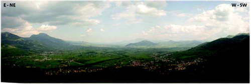
Since the Pliocene, contractional deformation in the eastern sector was accompanied by extensional tectonics in the western and axial part of the orogen. As a consequence, a series of oblique-slip to normal faults dissected the chain leading to the opening of several intermontane basins. Among them, the high Agri Valley is a NW-trending basin filled with Quaternary continental deposits that cover down-thrown pre-Quaternary rocks of the Apennine chain ().
Figure 2. Panoramic view of the high Agri Valley.
The aim of this paper is to present the geological map of an area of about 50 km2 located in the northeastern margin of the high Agri Valley, comprising the Marsicovetere and Villa d'Agri villages, where the main tectonic units of the Southern Apennines crop-out. This is a key area for understanding the deformation history and mountain building processes that occurred in the Southern Apennines. In the study area the original fold-and-thrust architecture of Southern Apennines is severely dissected by different fault sets with strike-slip to normal kinematics. Cross-cutting relationships between fault sets are particularly well exposed in several localities of the mapped area. This allows a detailed documentation of the late-to-post orogenic evolution of the area and, in a more general view, of the Southern Apennine chain. Most structures described in this investigation can easily be related to well-constrained episodes that have long been reported in a wide regional literature (CitationBonini & Sani, 2000; CitationCarbone et al., 1991; CitationCasero et al., 1988; CitationScandone, 1967; CitationScandone, 1972; CitationOgniben, 1969; CitationPatacca & Scandone, 2007; CitationVezzani et al., 2010). However, new data on the stratigraphic setting (mapping of the ‘Sorgente dell'Acero’ member) and on the lateto post-orogenic structures allow definition in more detail of the sedimentary evolution and tectonic setting of the area. For this reason, the geological map can be used to shed new light on the deformation history of the Southern Apennines, and particularly on the change from contraction to extension during the late to post-orogenic evolution of the chain.
2. Methods
We carried out geological mapping in an area of about 50 km2 comprising part of the Marsicovetere, Calvello and Viggiano administrative municipalities. The geological survey was mapped at the 1:10,000 scale, and published at 1:25,000 scale (Carta Topografica d'Italia – Serie 25 – I.G.M.). We prefer to use the 1:25,000 scale because it appears to be the most adequate to illustrate the geometry of the main map scale structures. Moreover, the 1:25,000 scale represents a homogeneous format that may be used to extend the geological survey to adjacent areas in the future.
Structural analysis of brittle structures has been performed in order to decipher the succession of deformational events that formed the present-day structural architecture. Structural data include the orientation of fault surfaces, slickenside lineations and shear sense indicators. Faults and striae were plotted as great circles, with the arrow corresponding to the slip direction of the hanging-wall respect to the footwall, using the FaultKinWin software.
3. Stratigraphy
The lithostratigraphic units outcropping in the study area () are arranged into four tectonic units superposed on the buried Apulian platform, in turn involved in a series of thrusts imaged only by subsurface data (CitationMenardi-Noguera & Rea, 2000; CitationMostardini & Merlini, 1986). Middle-to-late Miocene deep-sea siliciclastic deposits and Pleistocene continental breccia unconformably cover the tectonic pile.
Figure 3. Stratigraphic sections from the study area.
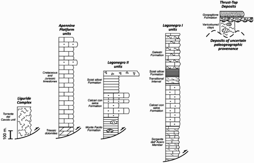
Starting from the highest position, the piled tectonic units correspond to:
| a. | The Liguride Complex derived from the deformation of an oceanic area of Tethyan affinity (CitationBonardi, D'Argenio, & Perrone, 1988), identified as the Ligurian domain (CitationStampfli, Borel, Marchant, & Mosar, 2002). In the study area the Liguride Complex is represented by the Middle-to-late Oligocene Torrente del Cavolo unit ( that mainly consists of grey shale, light grey marl and mixed calciclastic-siliciclastic turbidites, similar to the dominant lithologies of the late Eocene-late Oligocene Saraceno Fm (CitationBonardi et al., 1988). Intense deformation of this unit is documented by development of cleavage in marls and by the frequent presence of overturned beds. The ‘Torrente del Cavolo’ unit is generally overlain by the Miocene Albidona Fm, consisting of siliciclastic turbidites with intercalations of carbonate megaturbidites. It represents a lower-middle Miocene syn-orogenic sedimentary cycle post-dating the Burdigalian tectonic phase (CitationPatacca & Scandone, 2007). The Albidona Fm is exposed in the western sector of the high Agri Valley, near the Torrente del Cavolo-type locality (CitationCarbone et al., 1991). | ||||
| b. | The ‘Varicoloured clays’ (‘Argille Varicolori’), consisting of a mixture of varicoloured shale calcilutite marls, calcarenites and subordinate sandstones, generally referred to as the ‘Argille Varicolori’ unit and the Corleto Perticara Fm (CitationPescatore, Renda, Schiattarella, & Tramutoli, 1999). Since the paleogeographic position of the ‘Varicoloured clays’ is controversial, the tectonic evolution of these units represents a first order problem in the geology of Lucanian Apennines. According to several authors (CitationCarbone et al., 1991; CitationLentini, 1979; CitationOgniben, 1969; CitationPatacca & Scandone, 2007) the ‘Varicoloured clays’ are part of the Sicilide unit, whose paleogeographic provenance has been determined to be a basin located between the Ligurian domain and the Campanian-Lucanian platform. Alternatively, CitationMattioni, Le Pourhiet, and Moretti (2006) interpreted the ‘Varicoloured clays’ exposed in the study area as derived from the Tertiary sedimentation within the Lagonegro basin. Since the provenance of the ‘Varicoloured clays’ is not significant for the aim of the present work, we conservatively indicate that this unit has an uncertain paleogeographic derivation. The age of the Argille Varicolori Unit range from Late Cretaceous to Oligocene. | ||||
| c. | The Apennine platform units consist of thick successions of Triassic to early Miocene carbonates and transitional units mainly consisting of slope-to-basin resedimented limestones, covered by Miocene siliciclastic flysch (CitationD'Argenio, Pescatore, & Scandone, 1973; Palladino, Parente, Prosser, & Di Staso, 2008). We refer the Apennine platform unit outcropping in the study area to the Monti della Maddalena Unit, following CitationBonardi et al. (1988), even though CitationMenardi-Noguera and Rea (2000) suggest a different interpretation. It consists of a carbonate succession characterized by several stratigraphic hiatuses and abundance of resedimented material (. The basal part of the succession is represented by white dolomite grading into dolomitic limestone and limestone in which both cyclic peri-tidal facies and brecciated facies are present (CitationMarsella & Pappone, 1986; CitationScandone & Bonardi, 1968). The upper part of the succession is highly variable in that it may contain in each section Liassic, Dogger-Malm, Upper Cretaceous and Eocene carbonates, separated by unconformities. | ||||
| d. | Units derived from the Lagonegro basin, developed during the Mesozoic on an attenuated continental crust (CitationD'Argenio et al., 1973; CitationMostardini & Merlini, 1986; CitationScandone, 1972). The Lagonegro succession has regionally been decoupled into several major thrust sheets during the Miocene contractional tectonic events (CitationPatacca & Scandone, 2007). Two units of this tectonic pile crop out in the study area, as well as in wide sectors of the central Lucania: these are known as the Lagonegro I and Lagonegro II units (CitationScandone, 1967, Citation1972). The upper thrust sheet (Lagonegro II unit) consists of Middle Triassic to Lower Cretaceous basinal marine deposits with abundant calciclastic material derived from the adjacent carbonate platform. The lower thrust sheet (Lagonegro I Unit) is composed of Upper Triassic to Lower Cretaceous deep-water deposits displaying more distal features than the coeval deposits of the Lagonegro II unit. In the northeastern part of the study area the lower part of the Lagonegro II unit crops out; instead, the Lagonegro I succession outcrops extensively in the western part of the area. From oldest to youngest, the Lagonegro successions are divided into the following formations: | ||||
(i) The ‘Monte Facito Fm (Lower and Middle Triassic), outcropping only at the base of the Lagonegro II succession, consists of an assemblage of shale, marl, siltstone, sandstone, nodular limestone and organogenic carbonate; (ii) the Calcari con Selce Fm (Upper Triassic) consists of cherty limestone; (iii) the ‘transitional interval’, made up of alternating cherty limestone, radiolarites and red shale, represents the upper portion of Calcari con Selce Fm (CitationBertinelli et al., 2005a; CitationBertinelli, Ciarapica, & Passeri, 2005b) and marks the gradual transition from prevailing carbonate sedimentation to siliceous-radiolaritic deposits; (iv) the Scisti Silicei Fm (Upper Triassic and Jurassic) (, consists of regularly thin-bedded argillite and radiolarite; (v) the Galestri Fm (Lower Cretaceous), whose deposition is related to renewed terrigenous input in the basin since it consists of argillite with subordinate marl and calcilutite.
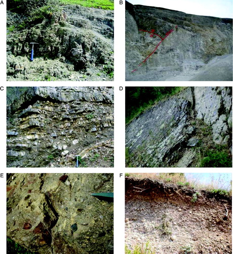
Figure 4. (A) Green and red shale and subordinated sandstones belonging to the ‘Torrente del Cavolo’ unit outcropping in the Sorgente Copone area. (B) Basal part of the ‘Apennine platform’ succession in a quarry around the town of Marsicovetere. The lower part of the quarry (light grey) is composed of Triassic dolomite; the upper part (dark grey) is made up of Jurassic limestone. Low angle (a) and high angle (b) tectonic contact separate the two lithofacies. (C) ‘Sorgente dell'Acero’ member at the base of the Mt. Corno section. (D) Typical rocks association within the distal facies (Lagonegro I) of ‘Scisti silicei’ Formation at Mt. Farneta. (E) Polygenic conglomerate belonging to coarse grained facies of the ‘Gorgoglione’ flysch, outcropping in the Serra la Mandra area. (F) Roughly stratified breccias referred to the lower and middle Pleistocene (CitationGiano et al., 2000). (Hammer is ca.30 cm long).
By comparing the Lagonegro II and the Lagonegro I Units, important facies and thickness variations, probably related to syn-sedimentary tectonics, are recognized in Calcari con Selce Fm . Although in both Units the Calcari con Selce Fm is mainly formed of thin-bedded cherty mudstones, calcarenitic beds are more abundant in the Lagonegro II Unit. Calcirudites, rich in cherty clasts are also present, often associated with paraconglomerates with fine-grained matrix, indicating gravity flows that affected basinal sediments (CitationPasseri et al., 2005). This facies association may indicate slope steepening within the pelagic environment, probably connected to syn-sedimentary extensional tectonics. The overall thickness of the Calcari con Selce Fm. of the Lagonegro II Unit is about 250 m. The Calcari con Selce Fm of the Lagonegro I Unit mostly consists of cherty mudstones often containing radiolarians, sponge spicules and thin-shelled bivalves, indicating a deep pelagic environment. Alternances of mudstones and shales, in levels ranging in thickness from a few millimetres to a metre, are also frequent. The overall thickness of the Calcari con Selce Fm in the Lagonegro I Unit is between 450 and 500 m.
At the base of the Lagonegro I succession the Monte Facito Fm is lacking (CitationPatacca & Scandone, 2007). In its place, at the base of ‘Calcari con Selce’ Fm, a particular lithofacies consisting of brown shale, marl, dark grey calcilutite and calcarenite, is exposed in a restricted area located between Mt. Farneta and Mt. Corno. We distinguish such lithofacies from ‘Calcari con Selce’ Fm on the basis of lithological, sedimentological and structural characteristics.
We refer this particular lithofacies to the Sorgente dell'Acero member (, according to CitationScandone (1967) and CitationPatacca and Scandone (2007), who observed a similar succession in the Sorgente dell'Acero locality, just a few kilometres northwest of the mapped area.
The Sorgente dell'Acero Member is exposed in zones of axial culmination at the core of map scale anticlines involving deposits of the Lagonegro I Unit. The lithological characteristics of the Sorgente dell'Acero Member significantly differ from those of the Calcari con Selce Fm. The Sorgente dell'Acero Member consists of alternating limestone and marl layers, ranging in thickness from 15 cm to 1 meter, and brown/greenish shaly levels, ranging in thickness from 10 to 30 cm. The limestone beds often show lateral variations in thickness and sedimentary structures such as bioturbation, plane-parallel lamination and cross lamination. Limestone contains radiolarians and pelagic bivalves, as is observed in the pelagic basinal facies typical of the transition between the Monte Facito and the Calcari con Selce Fms. (CitationWood, 1981). Marly and calcarenitic strata dominate over calcilutes; chert nodules have been found only in the stratigraphically highest levels, close to the contact with the Calcari con Selce Fm.
The Sorgente dell'Acero Member shows a remarkable lateral continuity at the base of the Lagonegro I Unit (CitationBucci, 2009; CitationScandone, 1967), with a minimum thickness on the order of 50 m estimated from outcrop data. It provides an important constraint to the thickness of the overlying Calcari con Selce Fm. For this reason it was mapped as a distinct unit.
The Miocene to Quaternary deposits that unconformably overlie the tectonic pile are:
| a. | Langhian to Tortonian syntectonic siliciclastic and calciclastic successions of the so-called Irpinian basin (CitationPescatore, 1978), represented in the study area by Gorgoglione Fm. They outcrop in limited areas around the Serra La Mandra area. The stratigraphic sequence of the Gorgoglione Formation consists of turbiditic sandstones and subordinate polygenic conglomerates (. The entire Gorgoglione Formation is considered, in the geological literature, as a piggyback-basin deposit (CitationPescatore & Senatore, 1986). | ||||
| b. | Lower and middle Pleistocene, roughly bedded, slope and talus deposits, consisting of clast-to matrix-supported, coarse-grained breccias with interbedded reddish paleosols; this lithofacies grades laterally into roughly stratified fine-grained breccias ( containing a reddish sand or clay matrix. Clasts shape ranges from angular to sub-angular, whilst matrix is a mixture of fine to coarse sands, containing terra rossa-type, reddish-brown mud and scattered pebbles. As a whole, such deposits are from a coarse-grained slope to alluvial depositional systems (CitationAmato & Cinque, 1992; CitationAmore et al., 1996; CitationCaldara, Loiacono, Morlotti, Pieri, & Sabato, 1988; CitationDi Niro, Giano, & Santangelo, 1992; CitationPatacca & Scandone, 2007; CitationVezzani, 1966). | ||||
| c. | Quaternary loose talus and slope deposits resulting from sediment-gravity flows produced both by bedrock cliff and slope failure. | ||||
4. Structural evolution
In the mapped area, we recognized several structures related to different tectonic events that developed during the southern Apennines deformation history, including pre-orogenic extension related to the Mesozoic rifting (a), orogenic contraction (b), and late-to post-orogenic strike-slip and extensional deformation (c).
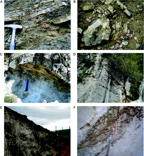
| a. | The effects of the pre-orogenic extension are often unclear because they have been overprinted by the Neogene deformations. Pre-orogenic extension was active since Triassic time, when the differentiation from distal to proximal facies (Lagonegro I and Lagonegro II units, respectively) occurred within the Lagonegro basin. Differentiation was probably promoted by the activity of syn-sedimentary normal faults. The main differences between the two units include: (i) a noticeable thickness variation in the Carnian-Norian Calcari con Selce Fm (from about 450–500 m in the Lagonegro I Unit to 250 m in the Lagonegro II Unit); (ii) the presence of different successions below the Calcari con Selce Fm: the Sorgente dell'Acero Member, of probable Carnian age, in the Lagonegro I Unit and a Carnian transitional interval (CitationPasseri & Ciarapica, 2010) to the underlying Anisian-Ladinian Monte Facito Fm in the Lagonegro II Unit. Summing up, both observations indicate a thicker Carnian succession in the Lagonegro I Unit, possibly connected to the activity of syn-sedimentary normal faults. The occurrence of meso-scale syn-sedimentary normal faults within the Sorgente dell'Acero Member, on the northwest side of Mt. Corno (, is consistent with this hypothesis. Strike of meso-scale syn-sedimentary normal faults ranges between N-S and NE-SW, with dip pointing mostly to the W-NW. Such faults produced moderate displacement, from centimetres to decimetres. The orientation of the meso-scale structures is comparable with the attitude of large-scale syn-sedimentary faults, described or postulated in the local geological literature (CitationBucci, D'Onofrio, Tavarnelli, & Prosser, 2006; CitationMiconnet, 1982; CitationScandone, 1972; CitationTavarnelli & Prosser, 2003). In addition, this is consistent with the evolutionary scheme proposed by CitationMazzoli et al. (2001), which indicate that thickness variations of the Calcari con Selce Fm in different Lagonegro units are related to the activity of synsedimentary normal faults. This interpretation has been applied to the marked thickness difference of the Calcari con Selce Formation at Mt. Torrette (Lagonegro II unit) and in the Mt. Volturino area (Lagonegro I unit), in the northern sector of the study area. | ||||
| b. | At map scale the onset of syn-orogenic contraction is outlined by the emplacement of the Monti della Maddalena thrust sheet and the development of thrusts and folds in the Lagonegro units. In the study area the original thrust contacts between the Lagonegro I and Lagonegro II units and between the Lagonegro units and Monti della Maddalena unit are poorly preserved, because they are reworked by the activity of late-to post-orogenic extensional structures. The Lagonegro II unit is tectonically superposed on the Lagonegro I unit along a N-S striking fault, gently dipping towards the east (Mt. Torrette area, northern sector of the map). The tectonic contact between the Monti della Maddalena Unit and the Lagonegro I Unit is buried under slope deposits; the inferred fault surface trends roughly NW-SE and dips gently toward NE (Serritello area, central sector of the map). Although the emplacement of the Monti della Maddalena thrust sheet may be coeval with substantial deformation of the Lagonegro Units, the onset of thrusting leading to the emplacement of Lagonegro II onto Lagonegro I Unit cannot be directly dated, as the youngest sediments on top of the lower nappe in the study area are Lower Cretaceous in age and thrusting is certainly much younger. According to CitationScandone (1972), deformation probably initiated in Langhian time, as indicated by the syntectonic sedimentation of the Langhian to Tortonian Gorgoglione Fm. Folds are particularly well developed in the Lagonegro I Unit; in the study area the best examples are the north-trending Mt. Farneta and Mt. Corno anticlines. Parasitic folds to the major meso-scale structures ( and clevage pattern in beds with high competence contrast indicate that the folds originated by buckling. One of the conditions necessary to ensure development of folds by buckling is the presence of a strong viscosity contrast between a competent multilayer and the matrix (CitationRamberg, 1964). The Sorgente dell'Acero Member, consisting of a regular alternation of shales, marls and calcarenites, shows strong lithological similarities with the Galestri Fm. In addition, the two formations are less competent/viscous when compared with the strong multilayer made up by the Calcari con Selce and Scisti Silicei Formations. As a consequence, the Sorgente dell'Acero and the Galestri Formations confine the multilayer, acting as lower and upper detachment matrix, respectively. This allows the nucleation and amplification of folds by a buckling mechanism. | ||||
| c. | The study area is strongly affected by late to post-orogenic strike-slip and normal faults that promoted the opening and deepening of the Agri Valley basin. The most visible effect of this tectonic stage is represented by a fault system oriented around N 110o-120o. The Fault system strongly affects roughly stratified talus breccias of early to middle Pleistocene age (CitationDi Niro et al., 1992), which appear faulted against the Mesozoic bedrock (. Two sets of slip lineations are observed on these fault surfaces (stereonet ‘C’ in the Geological Map). The first set indicates left- oblique slip and it is consistent with the left-lateral strike-slip kinematics already recognized for the Agri Valley fault system (CitationCello et al., 2000). The second set of slip lineations are superposed on the first set and indicate dip-slip motion (. These structures offset a series of normal faults with an average orientation around N 30o–40o (; structural diagram ‘B’ in the Map) bounding the ‘Sorgente Copone’ graben, located between Mt. Viggiano and Mt. Corno, where mixed calcareous-siliciclastic turbidites of the Liguride Complex (‘Torrente del Cavolo’ unit) extensively crop out. | ||||
Figure 5. (A) Pre-orogenic outcrop-scale normal fault within the ‘Sorgente dell'Acero’ member. (B) Meso-scale fold within bedded micritic limestone belonging to the ‘Sorgente dell'Acero’ member. (C) Low angle normal fault within Campanian-Lucanian limestone in a quarry near Serritello locality. (D) Moderately dipping normal fault bounding the western flank of the Sorgente Copone graben. (E) Recent normal fault cutting the Eastern flank of the high Agri Valley. (F) Slickenside striations on a recent normal fault plane bounding the high Agri Valley. (Hammer is ca.30 cm long; Pen is ca.10 cm long).
Locally, within the Apennine platform unit, a population of north-trending, eastward dipping, low angle (from 20o to 40o) normal faults, have been recognized (; structural diagram ‘A’ in the Map). These low angle faults are offset by the N 30o–40o trending fault system of the ‘Sorgente Copone’ graben. This suggests that structures related to an earlier extensional stage are preserved in the study area. According to CitationFerranti, Oldow, and Sacchi (1996), low angle normal faults in the Southern Apennines accommodated arc parallel extension during late Miocene and Pliocene times. In the study area this extensional process is not recorded since most of the low angle normal faults show NE-directed kinematics along E-to NE-dipping slip surfaces. Normal faults develop along the basal tectonic contact of the Lagonegro II and the Apennine platform units. In addition they are frequently developed within the Apennine Platform, at the boundary between Triassic dolomite and Jurassic limestone. These observations suggest that low angle extensional detachments reworked weak horizons, such as shear zones related to previous east-directed thrust surfaces and major lithological discontinuities.
5. Conclusions
Stratigraphic and structural data provided important constraints on the structures (1) and on the tectonic evolution of the axial part of Southern Apennine (2).
| 1. | A particular lithofacies, the ‘Sorgente dell'Acero’ member, was described and first mapped in the study area. It shows remarkable lithological, sedimentological and structural differences with the Calcari con Selce Formation, including: lack of chert nodules, higher amount of shale and marls and high frequency of sedimentary structures in fine-grained calcarenites. The Sorgente dell'Acero Member provides an important constraint to the thickness of the overlying Calcari con Selce Formation. Respectively above and below the Calcari con Selce Formation, the ‘Transitional Interval’ and the ‘Sorgente dell'Acero’ member, provide two excellent structural markers to define in detail the geometry of map-scale folds that affect the sequence of Lagonegro I Unit. The Calcari con Selce plus the Scisti Silicei Formations make up a strong multilayer, sandwiched between the Sorgente dell'Acero and the Galestri Formations, which act as lower and upper detachment matrix, respectively. This allowed the nucleation and amplification of folds by a buckling mechanism. The thick (exceeding 450 m) Calcari con Selce Formation acted as the dominant member of the folded multilayer, and hence controlled the size and the geometry of the folds. | ||||
| 2. | The study area has recorded a history of superposed deformations that correlates well with the evolution of the Southern Apennines of western Lucania. | ||||
Most structures described in the study area can easily be related to well-constrained episodes that have long been reported in a wide regional literature. They include the syn-rift deposition of sedimentary succession in basin and platform environments and the evolution of the Apennine fold-and-thrust belt that, in turn, was significantly modified by strike-slip and extensional tectonics since the Pleistocene.
Compared to the literature data, the new geological map allows a more detailed reconstruction of the late-to post-orogenic structures in a representative area of the Southern Apennines. Using cross-cutting and overprinting relationships between the different late-to post-orogenic faults populations mapped in the study area, we deduce that the low angle faults represent the first step in the processes that operated during the complex switch from contractional tectonics to the later orogenic extension. Low angle normal faults were, in turn, truncated by more recent sets of high angle strike-slip and normal faults that became the dominant structural features from Pleistocene time onwards, leading to the development of the seismically and tectonically active high Agri Valley basin.
The complex late-to-post orogenic deformation history documented in the study area provides important constraint to separate the effects of ancient structures from those of potentially active ones and may provide useful insights into the processes that operate during the development and evolution of post-orogenic troughs.
Software
The map and sections were created using Adobe Illustrator CS 4.
Supplemental Material - Map
Download PDF (9.6 MB)Acknowledgements
We are grateful to Barbara Terrosi for assisting in production of digital map. We thank Sabina Bigi, Andrea Festa and Randall C. Orndorff for their constructive comments that significantly helped to improve the manuscript.
References
- Amato , A. and Cinque , A. 1992 . Il bacino plio-pleistocenico di Calvello (Potenza): Evoluzione geologica e geomorfologica . Studi Geologici Camerti, Spec. 1992/1 , : 181 – 189 .
- Amore , F. O. , Ciampo , G. , Di Donato , V. , Esposito , P. , Santini , U. and Staiti , D. 1996 . Biostratigraphy of the Plio-Pleistocene Calvello basin (Potenza, Italy) . Memorie della Società Geologica Italiana , 51 : 1153 – 1163 .
- Bertinelli , A. , Ciarapica , G. , De Zanche , V. , Marcucci , M. , Mietto , P. , Passeri , L. and … Roghi , G. 2005a . Stratigraphic evolution of the Triassic-Jurassic Sasso di Castalda succession (Lagonegro basin, Southern Apennines, Italy) . Bollettino della Società Geologica Italiana , 124 ( 1 ) : 161 – 175 .
- Bertinelli , A. , Ciarapica , G. and Passeri , L. 2005b . Late Triassic-Jurassic basinal successions in Molise and northern Lucania: The northernmost witness of the Lagonegro domain . Bollettino della Società Geologica Italiana , 124 ( 1 ) : 177 – 188 .
- Bonardi , G. , Amore , F. O. , Ciampo , G. , De Capoa , P. , Miconnet , P. and Perrone , V. 1988 . Il complesso liguride auct: stato delle conoscenze e problemi aperti sulla sua evoluzione pre-appenninica ed i suoi rapporti con l'Arco Calabro . Memorie della Società Geologica Italiana , 41 : 17 – 35 .
- Bonini , M. and Sani , F. 2000 . Thrusting, strike-slip faulting and syntectonic deposition in the Potenza-guardia Perticara Area (Basilicata, Southern Apennines, Italy) . Memorie della Società Geologica Italiana , 55 : 123 – 132 .
- Bonardi , G. , D'Argenio , B. and Perrone , V. 1988 . Carta geologica dell'Appennino meridionale alla scala 1:250.000 . Memorie della Società Geologica Italiana , 41 : 1341
- Bucci , F. 2009 . Growth and dissection of a collisional chain: Tectonic evolution of the Southern Apennine within the high Agri valley deformative record. Unpublished PhD thesis, University of Siena, Italy
- Bucci , F. , D'Onofrio , D. , Tavarnelli , E. and Prosser , G. 2006 . Eredità strutturale nel processo di inversione tettonica positiva: un esempio dalle Unità Lagonegresi della Lucania Centrale, Italia . Rendiconti della Società Geologica Italiana, Nuova Serie , 2 : 101 – 102 .
- Caldara , M. , Loiacono , F. , Morlotti , E. , Pieri , P. and Sabato , L. 1988 . I depositi pliopleistocenici della parte nord del Bacino di S.Arcangelo (Appennino Lucano): caratteri geologici e paleoambientali . Memorie della Società Geologica Italiana , 41 ( fasc. 1 ) : 391 – 410 .
- Carbone , S. , Catalano , S. , Lazzari , S. , Lentini , F. and Monaco , C. 1991 . Presentazione della Carta Geologica del Bacino del Fiume Agri (Basilicata) . Memorie della Società Geologica Italiana , 47 : 129 – 143 .
- Casero , P. , Roure , F. , Endigoux , L. , Moretti , I. , Muller , C. , Sage , L. and Vally , R. 1988 . Neogene geodynamic evolution of the Southern Appennines . Memorie della Società Geologica Italiana , 41 : 109 – 120 .
- Catalano , S. , Monaco , C. , Tortorici , L. and Tansi , C. 1993 . Pleistocene strike-slip tectonics in the Lucanian Apennine (southern Italy) . Tectonics , 12 : 656 – 665 .
- Catalano , S. , Monaco , C. , Tortorici , L. , Paltrinieri , W. and Steel , N. 2004 . Neogene-Quaternary tectonic evolution of the southern Apennines . Tectonics , 23 TC2003. doi: 10.1029/2003TC001512
- Cello , G. , Gambini , R. , Mazzoli , S. , Read , A. , Tondi , E. and Zucconi , V. 2000 . Fault zone characteristics and scaling properties of the Val d'Agri Fault System (Southern Apennines, Italy) . Journal of Geodynamics , 29 ( 3–5 ) : 293 – 307 .
- Channel , J. E. T. , D'Argenio , B. and Horvath , F. 1979 . Adria, the African promontory in Mesozoic Mediterranean paleogeography . Earth Science Reviews , 15 : 297 – 301 .
- Ciarapica , G. , Cirilli , S. , Panzanelli Fratoni , R. , Passeri , L. and Zaninetti , L. 1988 . La Formazione di Monte Facito (Appennino meridionale). Atti del 74° Congresso Nazionale della Società Geologica Italiana, Sorrento, Abstract B: 132–135
- Di Niro , A. , Giano , S. I. and Santangelo , N. 1992 . Primi dati sull'evoluzione geomorfologica e sedimentaria del bacino dell'alta Val d'Agri (Basilicata) . Studi Geologici Camerti, Spec. , 1992/1 : 257 – 263 .
- D'Argenio , B. , Pescatore , T. and Scandone , P. 1973 . Schema geologico dell'Appennino Meridionale (Campania e Lucania). Atti del Conv: ‘‘Moderne vedute sulla Geologia dell'Appennino’' . Ass. Naz. Lincei , 183 : 49 – 72 .
- Ferranti , L. , Oldow , J. S. and Sacchi , M. 1996 . Pre-Quaternary orogen-parallel extension in the Southern Apennine belt, Italy . Tectonophysics , 260 : 325 – 347 .
- Giano , I. S. , Maschio , L. , Alessio , M. , Ferranti , L. , Improta , S. and Schiattarella , M. 2000 . Radiocarbon dating of active faulting in the Agri high valley, southern Italy . Journal of Geodynamics , 29 : 371 – 386 .
- Lentini , F. 1979 . Le Unità Sicilidi della Val d'Agri (Appennino Lucano) . Geol. Romana , 18 : 215 – 224 .
- Marsella , E. and Pappone , G. 1986 . Sediment gravity flows on a mesozoic carbonate slope. Monti della Maddalena (southern Apennines) . Rendiconti della Società Geologica Italiana , 9 : 219 – 224 .
- Mattioni , L. , Le Pourhiet , L. and Moretti , I. 2006 . “ In analogue and numerical modelling of crustal-scale proesses, rifting through a heterogeneous crust: Insights from analogue models an application to the Gulf of Corinth ” . Edited by: Buiter , S. J. H. and Schreurs , G. 213 – 231 . London : Geological Society, Special Publication .
- Mazzoli , S. , Barkham , S. , Cello , G. , Gambini , R. , Mattioni , L. , Shiner , P. and Tondi , E. 2001 . Reconstruction of continental margin architecture deformed by the contraction of the Lagonegro Basin Southern Apennines, Italy . Journal of Geological Society London , 158 : 309 – 319 .
- Menardi-Noguera , A. and Rea , G. 2000 . Deep structure of Campanian-Lucanian Arc (Southern Apennine, Italy) . Tectonophysics , 324 : 239 – 265 .
- Miconnet , P. 1982 . Précisions stratigraphiques et tectoniques dans un secteur du Lagonegro (Italie méridionale) . Ann. Soc. Geol. Nord , 102 : 17 – 24 . Lille
- Monaco , C. , Tortorici , L. and Paltrinieri , W. 1998 . Structural evolution of the Lucanian Apennines, Southern Italy . Journal of Structural Geology , 20 : 617 – 638 .
- Mostardini , F. and Merlini , S. 1986 . Appennino Centro Meridionale: Sezioni geologiche e proposta di modello strutturale . Memorie della Società Geologica Italiana , 35 : 177 – 202 .
- Ogniben , L. 1969 . Schema introduttivo alla geologia del confine calabro-lucano . Memorie della Società Geologica Italiana , 8 : 453 – 763 .
- Palladino , G. , Parente , M. , Prosser , G. and Di Staso , A. 2008 . Tectonic control on the deposition of the Lower Miocene sediments of the Monti della Maddalena ridge (Southern Apennines): Synsedimentary extensional deformation in a foreland setting . Bollettino della Società Geologica Italiana , 127 : 317 – 335 .
- Passeri, L., & Ciarapica, G. (2010). Le litofacies permiane e triassiche della formazione di M. Facito auctt. nell'area di M. Facito (successione di Lagonegro, Appennino meridionale). It. J. Geosci, 129(1), 29–50.
- Patacca , E. and Scandone , P. 2007 . Geology of Southern Apennines . Bollettino della Società Geologica Italiana (Ital. J. Geosc.), Special Issue , 7 : 75 – 119 .
- Pescatore , T. 1978 . Evoluzione tettonica del bacino Irpino (Italia Meridionale) durante il Miocene . Bollettino della Società Geologica Italiana , 97 : 783 – 805 .
- Pescatore , T. and Senatore , M. R. 1986 . A comparison between a present-day (Taranto Gulf) and a Miocene (Irpinian Basin) foredeep of the southern Apennines (Italy) . Spec. Publs. Int. Ass. Sediment. , 8 : 169 – 182 .
- Pescatore , T. , Renda , P. , Schiattarella , M. and Tramutoli , M. 1999 . Stratigraphic and structural relationshyps between m eso-cenozoic lagonegro basin and coeval carbonate platform in Southern Apennines, Italy . Tectonophysics , 315 : 269 – 286 .
- Piedilato , S. and Prosser , G. 2005 . Thrust sequences and evolution of the external sector of a fold and thrust belt: An example from the Southern Apennines (Italy) . Journal of Geodynamics , 39 : 386 – 402 .
- Ramberg , H. 1964 . Selective buckling of composite layers with contrasted rheological properties, a theory for simultaneous formation of several orders of folds . Tectonophysics , 1 ( 4 ) : 307 – 341 .
- Scandone , P. 1967 . Studi di Geologia Lucana: la serie calcareo silico marnosa e i suoi rapporti con l'Appennino calcareo . Boll. Soc. Natur. In Napoli , 76 : 1 – 175 .
- Scandone , P. and Bonardi , G. 1968 . synsedimentary tectonics controlling deposition of Mesozoic and Tertiary carbonatic sequences of areas surronding Vallo di Diano (Southern Apennines) . Memorie della Società Geologica Italiana , 7 : 1 – 10 .
- Scandone , P. 1972 . Studi di Geologia Lucana: carta dei terreni della serie calcareo-silicomarnosa e note illustrative . Boll. Soc. Natur. In Napoli , 81 : 225 – 300 .
- Stampfli , G. M. , Borel , G. D. , Marchant , R. and Mosar , J. 2002 . Western Alps geological constraints on western Tethyan recostruction . Journal of the Virtual Explorer , 8 : 77 – 106 .
- Tavarnelli , E. and Prosser , G. 2003 . The complete Apennines orogenic cycle preserved in a transient single outcrop near San Fele, Lucania, southern Italy . Journal of the Geological Society , 160 : 429 – 434 .
- Vezzani , L. 1966 . Nota preliminare sulla stratigrafia della Formazione di Albidona . Bollettino della Società Geologica Italiana , 85 ( fasc. 3–4 ) : 767 – 776 .
- Vezzani , L. , Festa , A. and Ghisetti , F. 2010 . Geology and tectonic evolution of the Central-Southern Apennines, Italy. Special Paper 469, Geological Society of America