Abstract
This paper presents the results of a sedimentological study performed to characterize the ‘Bosco Pantano di Policoro e Costa Ionica Foce Sinni’ coastal system, in Basilicata (southern Italy), as part of the PROVIDUNE LIFE Project. The study was focused on the morpho-sedimentological characterization of both the emerged and submerged sectors of the beach system developed along a 3.5 km-long segment of the Ionian coast. A multitemporal comparison of historical aerial photos of the studied coastline concerning the last 100 years was executed. A geomorphological survey was carried out along 36 topographic profiles (each up to 200-m long); these were coupled with bathymetric profiles, reaching a depth of −13 m. Both topographic and bathymetric profiles were measured on three occasions (July, October, December 2010). Textural and compositional analyses of sediments were also performed. The results of this study were synthesized in a series of maps illustrating a schematic geological outline of the study area, a reconstruction of the Sinni river course and shoreline changes from 1908 to 2010 (1:2,400 scale), significant topographic (1:1,300 scale) and bathymetric (1:5,000 scale) profiles, three bathymetric charts (1:31,000 scale) and morpho-sedimentological features of both the coastal and nearshore sectors (1:15,000 scale).
This study provides a geological background that is crucial for any intervention planning, as well as for any coastal zone management projects. The results should be also used in order to protect coastal habitats, which is the ultimate goal of the LIFE project.
1. Introduction
The PROVIDUNE LIFE project is a multi-disciplinary research task funded by the European Community and designed to outline the framework of the natural habitats of the dune fields that occur along the coastal zone included in Sites of Community Importance (SIC). The project focused on littoral zones comprised in the provinces of Cagliari (southern Sardinia), Caserta (northwestern Campania) and Matera (eastern Basilicata), in southern Italy. The main purpose of the PROVIDUNE LIFE project was the preservation and restoration of the coastal dune fields' natural habitats. The plan concerned a number of interconnected studies programmed to evaluate all the environmental features of some coasts of the central Mediterranean area. This paper summarizes the results of the study carried out during the sedimentological and marine-coastal dynamics investigations in the SIC area ‘Bosco Pantano Policoro e Costa Ionica Foce Sinni’ (CitationSabato, Longhitano, Cilumbriello, Gioia, & Spalluto, 2011a; CitationSabato et al., 2011b, Citation2011c), which is located in the southern Ionian coast of Basilicata, in the “Provincia di Matera” Government ( and Map 1). The studied coastal area has a length of about 3.5 km and the emerged sand/gravel beach has a width varying from some tens of meters up to about 200 m. In order to provide a comprehensive and useful framework for the project, this study involved both the emerged and submerged beach sub-environments down to the -13 m isobath. The main results of this study are summarized in a series of maps: (Map 1) a schematic geological setting of the area; (Map 2) a chart showing the evolution of the Sinni river course and coastline during the last century, at a 1:2,400 scale; (Map 3) some representative topographic and bathymetric profiles (at a 1:1,300 and 1:5,000 scale, respectively) performed during three different surveys (July, October and December 2010) and showing change in length and shape of the emerged and submerged sectors; (Map 4) three bathymetric charts produced from the three surveys (at a 1:31,000 scale), showing different positions and sizes of bedforms in the submerged sector; (Map 5) a chart of grain size distributions in the emerged and submerged sectors (at a 1:15,000 scale).
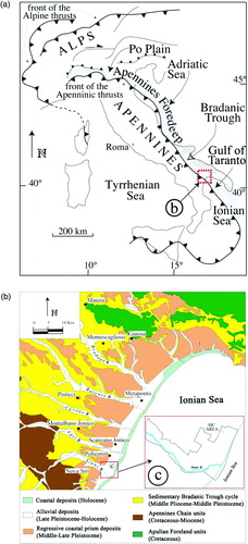
Figure 1. (a) Schematic structural map of Italy; the study area is in the dotted red box; (b) geological features of the southern sector of the Bradanic Trough in which the study area is located; (c) SIC area ‘Bosco Pantano di Policoro e Costa Ionica Foce Sinni’.
Recently, great attention has been paid to the problem of coastal erosion and consequent shoreline retreat along the Ionian coast (e.g. CitationBoenzi, Gallicchio, & Vitale, 2002; CitationChiocci & La Monica, 2008; CitationLonghitano, 2008; CitationRiccardi, Anzidei, Chiocci, Pescatore, & Spilotro, 2008; CitationSpilotro, Pizzo, & Leandro, 2008), however little or no action has been taken to prevent this phenomenon. In fact, against the continue construction of holiday villages and port facilities, repeated sand nourishment is required every year to mitigate coastal erosion. Therefore, this study represents an opportunity to observe the hydrodynamics of a small coastal system characterized by sand/gravel beaches and small natural aeolian dunes, still partially preserved from encroaching anthropogenic activity.
2. Methods
A complete sedimentological framework of the studied coastal system was produced using different methods. Firstly, existing geological, hydrological, meteo-marine and anemometric data were collected and critically analyzed; these latter were performed by processed data supplied by the Regional Agency for Environmental Protection in Basilicata (ARPAB). A multi-temporal analysis of coastline and Sinni River changes during the last 100 years (1908–2008) was carried out utilizing an historical map (year 1908, 1:100,000 scale; CitationAPAT, 2004) and aerial photos (years 1955 and 1990, at 1:33,000 scale from the Italian Military Geographical Institute, I.G.M.I.; years 1988 and 2008, at 1:10,000 scale from Basilicata Region); in addition, the 2010 coastline was obtained from a topographic survey performed during the project. All these data were processed within a geographical information system (GIS) and helped in the compilation of Map 2.
A geomorphological survey was also carried out along 36 normal-to-shoreline topographic profiles, up to 200 m long. Their traces, with 100 m spacing, were subsequently extended offshore as bathymetric profiles, reaching a depth of −13 m (for locations see Map 3). These data-acquisitions were performed three times (July, October, December 2010). Topographic profiles were acquired using a GPS RTK (Real Time Kinematic); more representative profiles are shown in Map 3. The bathymetric surveys were performed using a single beam echo sounder type Hydrobox 21; more representative profiles are shown in Map 3. The dataset was firstly analyzed using geostatistical techniques, and was successively processed into isobaths, in order to obtain a bathymetric map for each survey (see Map 4).
During the first topographic and bathymetric data acquisition sediment sampling was carried out, both on the emerged (foreshore and backshore sub-environments) and the submerged beach (shoreface environments up to offshore transition) (for location of sampling see Map 5), in order to characterize their textural and compositional parameters. The textural features were described using the most common laboratory grain size analyses (after CitationUdden, 1914 and CitationWentworth, 1922). Ruditic and arenitic fractions were measured through the use of a caliber and sieving. Compositional features were obtained through optical microscope observations. All these features were summarized in a map of grain size distribution encompassing both the emerged and submerged beach sectors (see Map 5). The grain-size contour map was constructed using the kriging as the spatial interpolation method (CitationDavis, 1986). The best-fit model used to derive the map was chosen on the basis of the comparison between predicted and real values of the variable.
3. Geological and meteo-marine setting
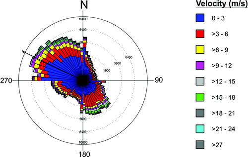
The SIC (Site of Community Importance) ‘Bosco Pantano di Policoro e Costa Ionica Foce Sinni’ is located in the south-eastern sector of the Basilicata, along the Ionian coast of Metaponto (hinterland of Gulf of Taranto), and includes the final tract and mouth of the Sinni River ( and Map 1). From a geological perspective, this area belongs to a sector of the Bradanic Trough (sensu CitationMigliorini, 1937) that represents the Pliocene to present-day South Apenninic foredeep, between the Apulian Foreland to the East and the Apenninic Chain to the West. In this sector middle-upper Pleistocene ‘terraced marine deposits’ (sensu CitationVezzani, 1967; cum. bibl.), made up of gravelly sandy regressive coastal prisms (CitationCilumbriello, 2008; CitationCilumbriello, Tropeano, & Sabato, 2008; CitationPieri, Sabato, & Tropeano, 1996), and the overlain Holocene sandy, gravelly sandy and sandy silty alluvial and coastal deposits (CitationBoenzi et al., 2002; CitationCilumbriello et al., 2010; CitationGrippa, 2010; CitationGrippa et al., 2011; CitationPescatore et al., 2009) crop out ( and Map 1). The nearshore sector is characterized by a 2.5 to 7.5 km-wide shelf, about 0.5°/1° dipping and with a margin (shelf break) located at a depth of −40/−60 m (CitationRegione Basilicata, 2005). The following slope is about 15 km wide, has an inclination of about 5°, and is characterized by a series of NW-SE trending submerged ridges, separated by canyons. These latter flow into the Taranto submarine valley (CitationPennetta, Pescatore, & Senatore, 1986, cum. bibl.). Sedimentological, mineralogical and anemometric studies carried out on a wider sector, including the studied SIC, identify a main direction of sediment dispersal (littoral drift) toward NE (CitationBelfiore, 1984; CitationBenassai, Cataldo, & Ragone, 1976; CitationBrondi, Ferretti, & Anselmi, 1974). This trend is confirmed by the study of the anemological climate obtained from processing ARPAB data. This dataset identified average wind speed values of 8.69 m/s, with dominant SE quadrant winds ().
Figure 2. Azimuthal diagram showing wind directions as a function of velocity. Wind data were collected over the last 10 years in an anemometric station located about 15 km North of the study area.
4. Historical analysis on the evolution of the area from aerial photogrammetry data
Analysis on the evolution of the coastline and the Sinni River course (Map 2) suggests that, from the early 1900s up to 1955 year, the Sinni River maintained roughly the same position, showing only a slight shift toward ENE. At the same time, the shape of the river mouth became most pronounced by prograding for over 530 m toward both N and S. This trend stopped in the 1955–1988 period, during which the mouth retreated by about 420 m. This shoreline change was accompanied by a significant lateral displacement of the mouth toward NE of about 800 m. An opposite trend was recorded during the 1988–1990 period, with a coastline progradation of almost 100 m at the Sinni River mouth. From 1990 to 2008 years the Sinni River mouth returned back to retrogradation, for an estimated distance of 150 m; laterally, particularly toward the N, the coastline was stable and, further N (just outside the study area) the coastline experienced a progradation of about 115 m. No significant lateral migrations of the Sinni River occurred during the same period. Finally, our recent data indicate a strong shoreline retreat of about 30 m at the Sinni River mouth, quantified for the 2008–2010 period. The overall retreat recorded from 1908 to 2010 years can be estimated at about 500 m. The amount of coastline retreat is comparable with that obtained by CitationSpilotro et al. (2008) even if over a more limited time interval.
5. Bathymetric and sedimentological analyses
During July, October and December 2010, three topographic and bathymetric surveys were performed in the study area. The comparison of the three multi-temporal measurements plotted for each topographic profile (Map 3) demonstrates a reduction in the length of the emerged beach during the winter season, with a major proportion in the southernmost sectors (see December topographic profile 27, Map 3). In contrast, the northernmost profiles do not display substantial changes in the three periods of acquisition (see topographic profile 7, Map 3).
The bathymetric profiles (Map 3) document the seafloor down to the −13 m isobath. Comparison between the three multi-temporal bathymetric profiles and the bathymetric maps obtained from each survey (Map 4) indicates the existence of two zones showing different morpho-bathymetric characteristics: (i) a proximal zone, extending to a distance of 400/500 m from the shoreline, characterized by a complex system of submerged bars alternated with troughs, with the bar toe at about −4 m depth and the bar crest at about −2 m depth; (ii) a distal area, located over a distance of 400/500 m from the shoreline, which develops from the outer limit of the last bar alignment to the offshore without any remarkable morpho-bathymetric changes. Furthermore, the bathymetric maps and profiles indicate that the transition from moderate energy regimes (summer season) to periods characterized by higher hydrodynamics (winter season) has not produced important morphological and bathymetric changes in the deepest areas of the beach system; on the contrary, a marked change in the bedforms is recorded in the proximal area, where the system of composite submerged bars shows remarkable changes both in shape and size.
As regards the sedimentological characteristics of the samples both in the emerged and submerged environments, the petrographic analyses indicate the presence of quartz, feldspars s.l., polimineralic lithics, carbonate lithics, bioclasts and accessory minerals ().
Figure 3. Pie charts showing petrographic compositions of sediments in different sub-environments of the study area coastal system.
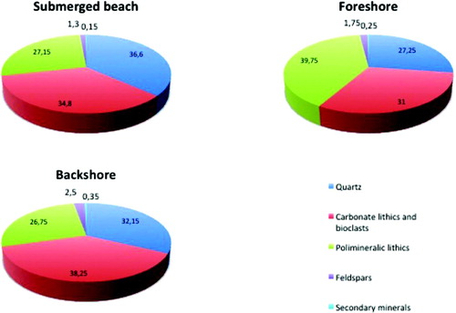
Grain size analysis indicates a marked sediment bimodality (gravel and sand) for the emerged beach: (i) the backshore is made up mostly of medium-coarse to fine sand, up to the back of the dune field (retrodunal area) where fine sand prevails; (ii) the foreshore is generally represented by very coarse sand (70/80%) and subordinately by gravel (20/30%). The submerged beach deposits exhibit very coarse to very fine sand, with a general and gradual decrease in the average diameter of the particles with increasing depth. This feature is quite clear in the morpho-sedimentological chart (Map 5) obtained by combining topographic and morpho-bathymetric data, together with the results of the sedimentological analyses. This map identifies an ‘anomaly’ in the grain size zonation in front of the Sinni River mouth, where the presence of fine sand was documented at a depth of −12.5 m; this is related to the occurrence of submerged delta sediments.
6. Conclusions
The results of this sedimentological and morphological study allowed us to characterize the coastal system of the ‘Bosco Pantano Policoro e Costa Ionica Foce Sinni’ and to highlight some critical environmental aspects of the area. Among these, the retreat of the shoreline in recent decades stands out, mostly linked to anthropogenic factors. For example, the construction in the late 1980s of a large earth dam along the Sinni River which has decreased sediment supply to the coast and so greatly reduced natural nourishment to the beach system. Also, natural factors may have contributed to an increase in shoreline retreat, including a recent sea-level rise recorded along Mediterranean coasts (e.g. CitationPirazzoli, 1996).
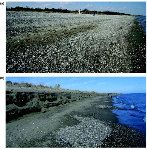
With regard to seasonal marine-coastal dynamics, the five-month survey highlighted important differences between the southern and the northern sectors. The maximum length of beach recorded in the northern area works as natural protection against wave erosion, and therefore the dune field has not shown significant changes during the acquisition period. Along the retreating southern beach sector, wave erosion has partially eroded the aeolian dunes, as demonstrated by a series of steep erosive berms, affecting the backshore formed during winter ().
Figure 4. Morphology of a stretch of beach, North of the Sinni River mouth in September (a) and in December (b) 2010. Note the clear storm berm developed during winter 2010.
Finally, the investigated coastal system was found to represent one of the most preserved sectors of the entire Basilicata Ionian coast. Holiday villages, recreational activities and port protections are widely diffused along the rest of the 80 km-long Ionian coastline, even around the main river mouth areas. Despite this strong environmental pressure, which results in a general shoreline retreat, many coastal features, including backshore vegetation and local foredunes, still maintain their natural aspect. The greater degree of ‘naturalness’ is also due to the site being declared a Site of Community Importance (SIC) in 1984 and therefore subject to special controls and access restrictions. In addition, a Visitor Center of the WWF (World Wildlife Fund), which performs an educational service for users of the beach, was constructed in the area.
This kind of study provides the geological background elements that must be taken into account for any intervention planning, as well as for any coastal management program. Throughout similar studies and consequent applications, coastal habitats can be correctly managed and preserved, as suggested by the guidelines of the LIFE project from which the present study derives.
Software
ESRI ArcGIS 9.2 was used to digitize the data collected during morpho-sedimentological and bathymetric surveys and to perform spatial and geostatistical analyses.
Supplemental Material - Map
Download PDF (6.4 MB)Acknowledgements
The authors wish to thank Prof. Tropeano for his useful suggestions that improved an early version of the manuscript. The authors are also grateful to Drs Chilton, Khalil, Otto and Zhamoida for revisions to the final version of the manuscript and the maps. Dr. Glisci (by ARPAB – Regional Agency for Environmental Protection in Basilicata, Potenza, Italy) is also acknowledged to have furnished anemometric data coming from the study area.
Thanks are due to Dr. Smith and Dr. White for their editorial patience.
The research was funded through an agreement between the ‘Dipartimento di Scienze della Terra e Geoambientali’ of the Bari University and the “Provincia di Matera” Government under the PROVIDUNE LIFE project, The study was also supported by ‘ex 60% 2010’ (Bari University), MIUR (PRIN-Cofin 2003) and “Regione Basilicata” Government (CARG- Basilicata Project) funds to Sabato.
References
- APAT (2004). Mapset. The complete archive of Italian geological cartography. DVD-Rom: Interactive Geological Map of Italy. F° 212 Tursi (1:100,000 scale).
- Belfiore , A. 1984 . La dispersione dei sedimenti nel settore occidentale del Golfo di Taranto [The sediment dispersal in the western sector of the Gulf of Taranto] . Bollettino della Società Geologica Italiana , 103 : 415 – 424 .
- Benassai , E. , Cataldo , P. and Ragone , A. 1976 . Inquadramento meteomarino dell'area campione dello Ionio [Meteomarine setting of the Ionian Sea sample-area] . Quaderni de ‘La Ricerca Scientifica’ , 94 : 3 – 21 .
- Boenzi, F., Gallicchio, S. & Vitale, G. (2002). Caratteri Geomorfologici della fascia costiera ionica in Basilicata. Final report Project: ‘Studio della costa ionica ed ipotesi di intervento per la salvaguardia e difesa del litorale, in relazione agli indirizzi di sviluppo socio-economico della Regione Basilicata’ Geomorphological features of the Ionian coastal belt in Basilicata. Final report Project: ‘Study of the Ionian coast and possible actions for the protection and defense of the coast, with relation to the orientations of socio-economic development of the Basilicata Region’, p. 28, 1 Tab., Regione Basilicata, Potenza.
- Brondi , A. , Ferretti , O. and Anselmi , B. 1974 . Deriva delle sabbie del litorale nord-occidentale del Golfo di Taranto [Sands drift of the north-western coast of Gulf of Taranto] . Rendiconti della Società Italiana di Mineralogia e Petrografia , 20 : 111 – 140 .
- Chiocci, F. L. & La Monica, G. B. (2008, May 26). Il problema dell'erosione dei litorali e le strategie per contrastarla, con considerazioni sull'assetto delle coste ioniche della Basilicata [The problem of coastal erosion and strategies to combat it, with considerations about arrangement of the Ionian coast of Basilicata]. In G. Spilotro (Ed.), Atti del Convegno: ‘L'arretramento della costa ionica della Basilicata: complessità, studi, azioni’ [Proceedings of the Conference: ‘The retreat of the Ionian coast of Basilicata: complexity, studies, actions’]. Metaponto. SIGEA, Geologia dell'Ambiente, 2, 71–75.
- Cilumbriello, A. (2008). Stratigrafia sequenziale dei depositi del Pleistocene medio-superiore del metapontino nell'evoluzione del bacino di avanfossa appenninico meridionale [Sequence stratigraphy of the middle-upper Pleistocene deposits of Metaponto in the evolution of Southern Apennine foredeep basin]. PhD Thesis, Bari University, p. 105.
- Cilumbriello , A. , Sabato , L. , Tropeano , M. , Gallicchio , S. , Grippa , A. , Maiorano , P. and Quarta , G. 2010 . Sedimentology, stratigraphic architecture and preliminary hydrostratigraphy of the Metaponto coastal-plain subsurface (Southern Italy) . Memorie Descrittive della Carta Geologica d'Italia , : 75 – 92 .
- Cilumbriello , A. , Tropeano , M. and Sabato , L. 2008 . “ The Quaternary terraced marine deposits of the Metaponto area (Southern Italy) in a sequence stratigraphic perspective ” . In Advances in application of sequence stratigraphy in Italy Edited by: Amorosi , A. , Haq , B. U. and Sabato , L. 29 – 54 . GeoActa Sp. Publ. 1
- Davis , J. C. 1986 . Statistics and data analysis in geology , New York , NY : John Wiley .
- Grippa, A. (2010). Studio stratigrafico-sequenziale di depositi costieri, affioranti e sepolti, dell'area metapontina (entroterra del Golfo di Taranto) [Sequence stratigraphy study of coastal deposits, outcropping and buried, of the Metaponto area (hinterland of Gulf of Taranto)]. PhD Thesis, Bari University, p. 209.
- Grippa , A. , Bianca , M. , Tropeano , M. , Cilumbriello , A. , Gallipoli , M. R. , Mucciarelli , M. and Sabato , L. 2011 . Use of the HVSR method to detect buried paleomorphologies (filled incised-valleys) below a coastal plain: The case of the Metaponto Plain (Basilicata, southern Italy) . Bollettino di Geofisica Teorica e Applicata , 52 ( 2 ) : 225 – 240 . doi: 10.4430/bgta0011, ISSN: 0006-6729
- Longhitano, S. (2008, May 26). Reperimento e compatibilità di sedimenti prelevati in aree continentali ai fini di azioni di ripascimento costiero: l'esempio dell'entroterra ionico della Basilicata [Retrieval and compatibility of sediments collected in continental areas for coastal nourishment: the example of Ionian hinterland of Basilicata]. In G. Spilotro (Ed.), Atti del Convegno: ‘L'arretramento della costa ionica della Basilicata: complessità, studi, azioni’ [Proceedings of the Conference: ‘The retreat of the Ionian coast of Basilicata: complexity, studies, actions’], Metaponto. SIGEA, Geologia dell'Ambiente, 2, 109–127.
- Migliorini, C. (1937). Cenno sullo studio e sulla prospezione petrolifera di una zona dell'Italia meridionale [Outline on the study and oil exploration in an area of southern Italy]. 2nd Petroleum World Congress, Paris, 1–11.
- Pennetta , M. , Pescatore , T. S. and Senatore , M. R. 1986 . I tipi di piattaforma continentale del Golfo di Taranto (Alto Ionio, Italia) [Continental shelf types of the Gulf of Taranto (northern Ionian Sea, Italy)] . Convegno ENEA ‘Evoluzione dei litorali’, Policoro , October 16–17 : 195 – 214 .
- Pescatore , T. , Pieri , P. , Sabato , L. , Senatore , M. R. , Gallicchio , S. , Boscaino , M. , Cilumbriello , A. , Quarantiello , R. and Capretto , G. 2009 . Stratigrafia dei depositi pleistocenico-olocenici dell'area costiera di Metaponto compresa fra Marina di Ginosa ed il Torrente Cavone (Italia meridionale): Carta Geologica in scala 1:25.000 [Stratigraphy of Pleistocene-Holocene deposits of the coastal Metaponto area between Marina di Ginosa and Cavone River (southern Italy): Geological Map, 1:25,000 scale.] . Il Quaternario , 22 ( 2 ) : 307 – 323 .
- Pieri , P. , Sabato , L. and Tropeano , M. 1996 . Significato geodinamico dei caratteri deposizionali e strutturali della Fossa bradanica nel Pleistocene [Geodynamic meaning of depositional and structural features of the Bradanic Trough during Pleistocene] . Memorie della Società Geologica Italiana , 51 : 501 – 515 .
- Pirazzoli , P. A. 1996 . Sea-Level changes: The last 20.000 years , Chichester: John Wiley & Sons Ltd .
- Regione Basilicata (2005). Carta Batimetrica [Bathymetric map]. In: Dipartimento Ambiente e territorio della Regione Basilicata (Ed.), Monitoraggio d'erosione costiera e caratterizzazione quali-quantitativa dei sedimenti a mare [Monitoring of coastal erosion and qualitative and quantitative characterization of marine sediments].
- Ricciardi, F., Anzidei, B., Chiocci, F. L., Pescatore, T. S., & Spilotro, G. (2008, May 15–17). Attività svolte nell'ambito del progetto di monitoraggio dell'erosione costiera e caratterizzazione quali-quantitativa dei sedimenti a mare della costa jonico-lucana. In Atti del Convegno: ‘Coste, Prevenire, Programmare, Pianificare’ [Activities carried out under the monitoring coastal erosion project and qualitative and quantitative marine sediment characterization of the Ionian-Lucanian coast. In Proceedings of the Conference: ‘Coasts, Preventing, Programming, Planning’]. Studi e Ricerche, 9, 629–637.
- Sabato, L., Longhitano, S., Cilumbriello, A., Gioia, D., & Spalluto, L. (2011a). Studi sedimentologici e dinamica marino-costiera. SIC Bosco Pantano di Policoro e Costa Ionica Foce Sinni [Sedimentological studies and coastal-marine dynamics. SIC Bosco Pantano di Policoro and Ionian coast of Sinni River mouth]. Technical-Scientific Report PROVIDUNE (LIFE 07NAT/IT/000519), p. 128.
- Sabato , L. , Longhitano , S. , Cilumbriello , A. , Gioia , D. , Spalluto , L. and Kalb , C. 2011b . Studio sedimentologico e dinamica marino-costiera del sistema litorale di Bosco Pantano di Policoro (Basilicata, Italia meridionale) [Sedimentological study and coastal-marine dynamics of the littoral system of Bosco Pantano di Policoro (Basilicata, southern Italy)] . Rendiconti Online della Società Geologica Italiana , 17 : 161 – 168 . doi: 10.3301/ROL.2011.46
- Sabato , L. , Longhitano , S. , Cilumbriello , A. , Gioia , D. , Spalluto , L. and Kalb , C. 2011c . La salvaguardia delle coste sabbiose: il caso-studio del sistema costiero del Bosco Pantano di Policoro (Basilicata). Atti Giornata Scientifica ‘Criticità geologiche del territorio pugliese: metodi di studio ed esempi’ [The protection of the sandy coasts: the case-study of the coastal system of Bosco Pantano di Policoro (Basilicata). Proceedings of the Conference: ‘Geological criticalities of Apulia: study-methods and examples’] . Bari , June 22 : 41 – 46 .
- Spilotro, G., Pizzo, V., & Leandro, G. (2008, May 26). Evoluzione della costa ionica della Basilicata e gestione della complessità [Evolution of the Ionian coast of Basilicata and management of complexity]. In G. Spilotro (Ed.), Atti del Convegno: ‘L'arretramento della costa ionica della Basilicata: complessità, studi, azioni’, Metaponto [Proceedings of the Conference: ‘The retreat of the Ionian coast of Basilicata: complexity, studies, actions’]. SIGEA, Geologia dell'Ambiente, 2, 19–40.
- Udden , J. A. 1914 . Mechanical composition of clastic sediments . Geological Society of America Bulletin , 25 : 655 – 744 .
- Vezzani , L. 1967 . I depositi plio-pleistocenici del litorale ionico della Lucania [Plio-Pleistocene deposits of the Ionian coast of Lucania] . Atti dell'Accademia Gioenia di Scienze Naturali in Catania VI , 18 : 159 – 180 .
- Wentworth , C. K. 1922 . A scale of grade and class terms for clastic sediments . Journal of Geology , 30 : 377 – 392 .