Abstract
A 1:5000 scale geomorphological landslide inventory map of the glaciated headwaters of the Gállego River in the Spanish Pyrenees is presented. This map, covering an area of 57.6 km2 and mainly produced by direct mapping in the field, provides a more comprehensive and accurate picture of the distribution of slope movements than previous maps. Around 20% of the area is affected by large flow-dominated slope movements developed on Paleozoic slates. Our map shows that some of these post-glacial landslides have blocked the main drainage at several sites creating landslide-dammed lakes. The damage caused by landslides in the mapped area, with an estimated cost of greater 10 million euros, is mostly related to the activity of pre-existing slope movements, some of which have been reactivated or accelerated by adverse human alterations (e.g., excavation at the toe, overloading, higher water infiltration). This study illustrates that the incorporation of detailed cartographic landslide inventories in the planning and development process of alpine areas may contribute to reduce significant landslide-related damage in a cost-effective manner.
Keywords:
1. Introduction
Cartographic landslide inventories constitute an essential basis for landslide hazard analysis and risk mitigation (CitationFell et al., 2008). The reliability of predictions on the future distribution of landslides and the effectiveness of mitigation measures depend largely on the completeness and accuracy of available landslide databases. A significant proportion of the landslide damage is related to the activity or reactivation of pre-existing slope movements. Moreover, mapped landslides provide the clues for delineating the most susceptible areas for the potential occurrence of new slope failures. A field-based 1:5000 scale landslide map has been produced for the headwaters of the Gállego River in the central Spanish Pyrenees. This glaciated area, covering 57.6 km2 and largely underlain by Paleozoic slates, includes the Formigal Ski resort, which constitutes the main source of income for the local economy. Land sliding has caused damage with a total cost in excess of 10 million euros on the infrastructure of the ski resort and the A-136 road that connects the valley with France through the El Portalet pass. This paper illustrates how detailed cartographic landslide inventories allied with preventive planning strategies can generate substantial economic savings and avoid development blight.
2. Methodology
A phased approach was followed to construct the geomorphological landslide inventory map of the upper Gállego Valley. Initially, a preliminary landslide map was produced on the basis of aerial photograph interpretation, a review of previous geomorphological and geotechnical information and data about specific slope movements provided by the technical staff of the Formigal-Aramón ski resort. Stereoscopic aerial photographs taken in 1957 and 2003, and printed at approximately 1:33,000 (grey tone) and 1:18,000 (colour) scales, were used at this stage. In the subsequent and most critical phase, the landslide map was delineated by direct field mapping over the whole area using 1:5000 scale orthophotographs. This task, which involved approximately eight days per person of work (∼1 day/person per 1 km2), allowed us to identify a significantly larger number of landslides than those shown in the preliminary map and in previous general and less detailed geomorphological and geotechnical maps (CitationBixel, Muller, & Roger, 1985; CitationChueca, Julián, Peña, & Spinalt, 2000; CitationGarcía-Ruiz, 1989; CitationGarcía-Ruiz, Chueca, & Julián, 2004; García-Ruiz et al., 2011; CitationMulas & Fresno, 2001; CitationSerrano, 1998). The mapped geomorphic features were digitised using Autocad 8.0. Landslide type was attributed following the classification proposed by CitationCruden and Varnes (1996). The map legend was derived from that used by the Italian Geological Survey, which differentiates the main types of slope movements. Finally, a database template was constructed for the 83 landslides more than 100 m in major axial length from a total of 209 landslides, including the identification number labelled in the map and entries related to the dominant movement type, evidence of activity and multiple morphometric parameters. Selected information from the database is presented in . The georeferenced 1:5000 topographic map and orthoimages used in this study are available from the Sistema de Información Territorial de Aragón (http://sitar.aragon.es/).
Table 1. Data derived from the landslide database, including dominant movement type and morphometric parameters of the 83 largest landslides. The identification numbers correspond to those labelled in the map. Landslide volume was calculated using an estimated average thickness on the basis of the type and geomorphic characteristics of the landslides, as well as the position of the basal sliding surface identified in some movements by means of geotechnical investigations. Total values refer to the 83 largest landslides included in the data-base.
3. Geographical and geological setting
The mapped sector mainly covers the headwaters of the Gállego River watershed upstream of the Lanuza Reservoir. A small portion of the Escarra River valley around the Escarra Reservoir and two complex movements in the French National Park of the Western Pyrenees were included because of their geomorphological and geotechnical significance. From the geological point of view, the study area is located in the Axial Zone of the Pyrenees, an extensive outcrop of the Variscan basement affected by complex contractional structures resulting from the superposition of the Variscan and Alpine orogenies. Three main stratigraphic suites bounded by major unconformities may be differentiated (CitationRíos, Balera, & Barettino, 1989): (1) A Devonian succession approximately 500-m thick dominated by slates that grade to reef limestones at the top. (2) Carboniferous limestones and slates with a total thickness of about 1000 m. (3) A Late Carboniferous and Permian sequence including coal-bearing slates and red continental clastic sediments with basalt flows and andesitic sills and laccoliths. The main lithostructural factors that control landslide distribution and type include: (1) Devonian and Carboniferous slates, with a dense network of cleavage planes, underlie around 80% of the mapped area. These highly fissile rocks, when affected by landslides, undergo a rapid reduction in strength (strain softening) and transform into a soft sediment with plastic rheology. (2) Major folds and thrusts show a prevailing S vergence and a WNW-ESE direction parallel to the trunk Gállego Valley. Consequently, in the northern flank of this glacial trough the strata generally dip into the slopes, whereas in the opposite wall the bedrock mainly dips towards the valley.
4. Geomorphological setting
The main geomorphic features of the study area are inherited from the erosional action of glaciers in the Late Pleistocene, largely controlled by the distribution of highly erodible slates and resistant rocks. The highest peaks and ridges, 1900–2500 m in elevation, are associated with outcrops of limestone, sandstone, conglomerate and andesite, frequently thrusted over Devonian and Carboniferous slates. Most of the glacial cirques, with an average width/length ratio close to 1, were carved in these hard rocks (CitationGarcía-Ruiz, Gomez-Villar, Ortigosa, & Marti-Bono, 2000). The cirques typically show active talus slopes, lakes and peatbogs in largely filled overdeepened basins and moraines developed during late retreat phases. A tongue-shaped talus rock glacier 600-m long and 200-m wide was mapped at the foot of a cliff on Permian sandstones at the headwaters of Culivillas Creek. The formation of this relict periglacial deposit may be related to the Younger Dryas cooling episode (CitationGarcía-Ruiz, Valero-Garcés, Martí-Bono, & González-Sampériz, 2003). In the topographically lower areas dominated by slates, the turf-covered landscape is characterised by rounded divides and landslide-related hummocky slopes. The original U-shaped morphology of the main and tributary glacial troughs was largely modified by the development of large deep-seated landslides on slates. This seems to be the reason for the scarcity of well-preserved moraines in the valleys, which are particularly abundant in the lower part of the Gállego valley.
5. Landslides
The mapped landslides cover 22.6% of the study area (13.6 km2). Active solifluction, although widely distributed in the area (CitationCreus & García-Ruiz, 1977), was not shown on the map due to the difficulty of defining the limits of the sectors affected by this shallow gravitational process with vague geomorphic imprint. Based on the estimated average thickness of each movement, the landslide deposits could amount to a total volume of around 4.8·108 m3. This indicates that landslides have mobilised around 8.3·104 m3 of material per hectare in the area.
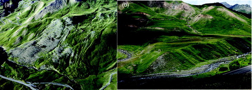
Flow-dominated complex movements in slates (, 2 and 3A) constitute 80% of the mapped landslides. These large mass movements account for 86% of the area affected by landslides (12 km2) and 97% of the cumulative landslide volume (4.6·108 m3), excluding talus slopes and solifluction. The slate flows reach 2800 m in length, 700 m in width and cover up to 1.46 km2. They typically form tongued-shaped deposits of highly brecciated slates that grade into translational or rotational slides in the upper part of the displaced mass. Translational movements are more abundant in the southern slope of the Gállego Valley, where bedding dips towards the valley (e.g., landslides n. 1, n. 18, n. 21). The toe and flanks of the flows are often affected by secondary failures induced by fluvial erosion caused by the Gállego River and lateral streams and the build up and oversteepening of the slide mass due to flow propagation. The earthflows developed at the foot of prominent limestone or andesite escarpments (landslides n. 31, n. 70 and n. 71) are typically mantled by a veneer of angular boulders supplied by rock falls and rock avalanches from the upper free face and transported downslope by the plastic deformation and sliding of the underlying slates (. Some of these boulder-covered slate flows with arcuate ridges and furrows have been erroneously interpreted as rock glaciers by CitationSerrano and Cuchí (2005). Surface displacement rates of the order of 0.5–1.5 cm/yr were measured by differential interferometric synthetic aperture radar (DInSAR) on some of these flows (CitationHerrera et al., 2009, Citation2011; CitationNotti, Davalillo, Herrera, & Mora, 2010). These values may correspond to the sum of deep-seated sliding, plastic flow affecting the whole landslide deposit and shallow movements (solifluction, soil slides). Locally, large flows superimposed on the bottom of the glacial troughs have blocked the drainage in the past creating landslide-dams and associated landslide lakes. The damming episodes are recorded by non-dissected infilled basins (e.g., upstream landslide n. 31; and by hanging and dissected lacustrine terraces (e.g., upstream landslides n. 21 and n. 45; .
Figure 1. (A) Landslide n. 31. Slate flows partially mantled by andesite boulders derived from the upper free-face scarp and subsequently transported downslope by the displacement of the underlying slates. Arrow points to an infilled lacustrine basin generated when the landslides blocked the Gállego River. (B) Dissected lacustrine terraces upstream of landslides 21 and 67.
Translational and rotational rock slides, mostly developed in Devonian slates, represent around 1.3% of the study area (0.77 km2) with a total estimated volume of 1.2·107 m3. They may reach 900 m in length, 300 m in width, and 0.2 km2 in area. Some of the rotational slides show secondary synthetic and antithetic failure planes expressed as downslope- and upslope-facing scarps (e.g., landslides n. 30 and n. 75). Rock avalanche deposits developed at the foot of limestone and andesite escarpments reach up to 550 m in length (landslide n. 40).
The initiation of a great part of the large deep-seated landslides was most probably related to the retreat of the glaciers and the consequent debutressing effect on the oversteepened valley walls. The Gállego glacier, as indicated by the moraines situated at a higher relative elevation, locally reached 400 m in thickness, involving an unloading of 36 kg/cm2 (3.6 MPa). The alpine glaciers in the Pyrenees reached maximum extent long before the Last Glacial Maximum established for continental ice-sheets at around 20 ka (i.e., CitationGarcía-Ruiz et al., 2003). Radiocarbon dates obtained from post-glacial lacustrine deposits in the study area provide minimum ages for the deglaciation. CitationGonzález-Sámperiz et al. (2006) dated at 32,183–33,773 calendar yr BP the base of the lacustrine fill of an overdeepened basin situated at 1800 m in the El Portalet area, next to landslide n. 53. In Tramacastilla Lake, at 1675 m in elevation, a conventional radiocarbon age of 29,400 ± 600 yr BP (35,067–32,346 cal yr BP) was obtained by CitationMontserrat (1992) from a sample collected in the lower lacustrine sequence. These data indicate that most of the mapped area was ice-free before 32 ka BP and consequently some landslides may be Late Pleistocene in age. This is in agreement with the date of 20,150 ±150 14C yr BP (24,473-23,650 cal yr BP) obtained by CitationGarcía-Ruiz et al. (2005) from the base of the lacustrine sequence deposited in the landslide-dammed basin formed in the Gállego Valley upstream of landslide n. 31, at the mouth of the Culivillas Creek (. The numerical dating of the samples already collected from the lacustrine sediments deposited in the basins upstream of landslides n. 31 and n. 45 will provide information on the minimum age of the landslides and the timing of damming episodes.
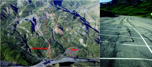
Although the development of many large landslides most probably started in pre-Holocene times soon after the retreat of the glaciers, geomorphic evidence and damage reported to human structures indicate that a significant proportion of these mass movements are still active. The kinematics of the landslides, largely controlled by the hydrological processes (i.e., snow melting, rainfall) that influence pore water pressure (CitationHerrera et al., 2011, and references therein), was dramatically accelerated is some cases due to anthropogenic alterations, mainly excavation at the toe, overloading and enhanced water infiltration. Damage caused by landslides in the area include: (1) Displacement of lift piles and abandonment of ski lifts (landslides n. 18 and n. 21). One of the main ski lifts, built on the obvious landslide n. 21, had to be relocated, causing temporary loss of serviceability, permanent reduction in its carrying capacity and financial losses in excess of 5 million euros (. (2) Continuous deformation of a parking lot ( built after excavating the toe of landslides n. 49 and n. 50. (3) Severe damage on several stretches of the A-136 road (landslides 1 and 6; . The cost of the correction measures applied on landslide n. 6, with limited success, exceeds 4 million euros. (4) Damage in a water pond built on a rotational landslide for artificial snowmaking (landslide 19). (5) Deformation of a bridge over the Gállego River, requiring its demolition (landslide 21). (6) Damage and partial abandonment of water services feeding hydropower plants (landslide n. 6 and secondary failure at the toe of landslide n. 71).
Figure 2. Deep-seated earthflows developed in Devonian slates. (A) Landslide n. 1 in the Lanuza Reservoir. The complex landslide is a slate flow that grades into a translational movement in the upper part. The fresh secondary failure at the flank of the landslide (shear zone) causes repeated damage on the A-136 road. (B) Earthflow n. 27 in the Culivillas Creek, largely reshaped due to the construction of ski tracks.
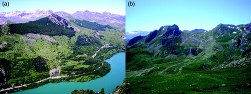
Figure 3. (A) Oblique aerial view of the active landslide n. 21. Red lines indicate the traces of the abandoned and new ski lifts. (B) Deformed pavement in a parking lot whose construction involved excavation at the toe of landslides n. 49 and n. 50.
6. Conclusions
The construction of comprehensive cartographic landslide inventories in mountain areas should be addressed at large scales (≥1:5000) by carrying out complete and thorough field surveys.
A significant proportion of the mapped area (∼20%) is affected by large flow-dominated landslides in slates. The distribution of these mass movements and the failure mechanisms are influenced by the attitude of the bedding with respect to the aspect of the slopes. Although many of the landslides show evidence of current or recent activity, it is likely that the majority of failures initiated soon after the deglaciation of the valleys more than 32 ka ago. Some slate flows have blocked the main drainages in the past creating landslide-dammed lakes.
The damage caused by landslides in the mapped area, with an estimated cost higher than 10 million euros, is mostly related to the activity of pre-existing slope movements, some of which were reactivated or accelerated due to adverse human alterations (excavation at the toe, overloading, enhanced water infiltration).
Cartographic landslide inventories constitute the basis to mitigate landslide risk in a cost-effective way through the application of preventive planning strategies. The map presented, whose cost could be roughly estimated at 30,000 euros, would have allowed mitigation of much of the damage in the area (>10 million euros). Hopefully, this 1:5000 scale cartographic infrastructure will constitute a helpful tool for the planning and development of the area in the future.
The geological map of this area, like in many others of the Spanish Pyrenees, greatly underestimates the distribution of large deep-seated landslides. Overlooking these surficial formations has a significant impact on the quality of the geological maps. A considerable proportion of the structural data represented may not have a tectonic, but a gravitational origin; strikes and dips measured in displaced landslide bodies and faults that correspond to landslide boundaries and gravitational failures. A similar situation has been documented in the Southern Rocky Mountains of Colorado by CitationMcCalpin (2008), revealing the advantage of incorporating field geomorphologists in the geological mapping process in alpine areas.
Software
The georeferencing and digitisation of the cartographic information was carried out using Autocad 8.0 and Esri ArcGIS 9.1.
tjom_a_751345_sup_30348538.pdf
Download PDF (2.2 MB)Acknowledgements
The research partially funded by projects DO-SMS-SOE1/P2/F157 (Interreg IV B SUDOE, EU-FEDER) and CGL2010-16775 (Ministerio de Ciencia e Innovación and FEDER).
Related Research Data
References
- Bixel , F. , Muller , J. and Roger , P. 1985 . Carte geologique. Pic du Midi d'Ossau et haut bassin du rio Gallego: Scale 1:25,000. Institut de Geodynamique , Bordeaux : Universite de Bordeaux III .
- Chueca , J. , Julián , A. , Peña , J. L. and Spinalt , M. 2000 . Mapa geomorfológico del Alto Gállego (Pirineo aragonés), Escala 1:50.000 . Boletín Glaciológico Aragonés, 1 ,
- Creus , J. and García-Ruiz , J. M. 1977 . Observaciones sobre la solifluxión en el Alto valle del río Gállego . Actas de la II Reunión Nacional del G.E.T.C , : 57 – 64 .
- Cruden , D. M. and Varnes , D. J. 1996 . “ Landslide types and processes ” . In Landslides, investigation and mitigation , Edited by: Turner , A. K. and Schuster , R. L. 36 – 75 . Washington , DC : National Academy Press .
- Fell , R. , Corominas , J. , Bonnard , C. H. , Cascini , L. , Leroi , E. and Savage W. Z. on behalf of the JTC-1 Joint Technical Committee on Landslides and Engineered Slopes . 2008 . Guidelines for landslide susceptibility, hazard and risk zoning for land use planning . Engineering Geology , 102 : 85 – 98 .
- García-Ruiz , J. M. 1989 . Mapa geomorfológico: Sallent (Huesca). E. 1:50,000 , Logroño : Geoforma Ediciones .
- García-Ruiz , J. M. , Chueca , J. and Julián , A. 2004 . “ Los movimientos en masa del Alto Gállego ” . In Geografía física de Aragón: Aspectos generales y temáticos , Edited by: Peña , J. L. , Longares , L. A. and Sánchez , M. 141 – 152 . Zaragoza : Universidad de Zaragoza e Institución Fernando el Católico .
- Garcia-Ruiz , J. M. , Gomez-Villar , A. , Ortigosa , L. and Marti-Bono , C. 2000 . Morphometry of glacial cirques in the Central Spanish Pyrenees . Geografiska Annaler , 82A ( 4 ) : 433 – 442 .
- García-Ruiz , J. M. , Valero-Garcés , B. , Martí-Bono , C. and González-Sampériz , P. 2003 . Asynchroneity of maximum glacier advances in the central Spanish Pyrenees . Journal of Quaternary Science , 18 : 61 – 72 .
- García-Ruiz , J. M. , Martí Bono , C. , Valero Garcés , B. and González Samperíz , P. 2005 . “ Central Spanish Pyrenees: Glacial and periglacial landforms ” . In Sixth International Conference on Geomorphology. Field Trip Guides , Edited by: Desir , G. , Gutiérrez , F. and Gutiérrez , M. 311 – 339 . Zaragoza : Universidad de Zaragoza .
- Garcia-Ruiz , J. M. , Pena-Monne , J. L. , Marti-Bono , C. , Gomez-Villar , A. , Constante-Orrios , A. and Espinalt-Brillas , M. 2011 . El relieve del Alto Aragon Occidental: Cartografia y sintesis geomorfologica. E. 1:50,000 , Zaragoza : Consejo de Proteccion de la Naturaleza de Aragon .
- González-Sampériz , P. , Valero-Garcés , B. , Moreno , A. , Jalut , G. , García-Ruiz , J. M. , Martí-Bono , C. and … Dedoubat , J. J. 2006 . Climate variability in the Spanish Pyrenees during the last 30,000 yr. revealed by the El Portalet sequence . Quaternary Research , 66 : 38 – 52 .
- Herrera , G. , Davalillo , J. C. , Mulas , J. , Cooksley , G. , Monserrat , O. and Pancioli , V. 2009 . Mapping and monitoring geomorphological processes in mountainous areas using PSI data: Central Pyrenees case study . Natural Hazards and Earth System Sciences , 9 : 1587 – 1598 .
- Herrera , G. , Notti , D. , Garcia-Davalillo , J. C. , Mora , O. , Cooksley , G. , Sanchez , M. and … Crosetto , M. 2011 . Analysis with C- and X-band satellite SAR data of the Portalet landslide area . Landslides , 8 : 195 – 206 . doi: 10.1007/s10346-010-0239-3
- McCalpin , J. P. Reevaluation of geologic hazards in a mountain setting. The case of the Climax 7.5' Quadrangle, Central Colorado . 33rd International Geological Congress . Oslo, Abstract .
- Montserrat , J. 1992 . Evolución glaciar y postglaciar del clima y la vegetación en la vertiente su del Pirineo: Estudio palinológico , Zaragoza : Instituto Pirenaico de Ecología .
- Mulas , J. and Fresno , F. 2001 . “ Geotecnia y peligrosidad natural ” . In El medio físico y su peligrosidad en un sector del Pirineo central , Edited by: Ríos , S. 81 – 102 . Madrid : IGME .
- Notti , D. , Davalillo , J. C. , Herrera , G. and Mora , O. 2010 . Assessment of theperformance of X-band satellite radar data for landslide zapping and monitoring: Upper Tena Valley case study . Natural Hazards and Earth System Sciences , 10 : 1865 – 1875 .
- Ríos , L. M. , Balera , J. and Barettino , D. 1989 . Memoria de la Hoja Nº 145 del Mapa Geológico de España: Sallent. Escala 1:50,000 , Madrid : ITGE .
- Serrano , E. 1998 . Geomorfología del Alto Gállego, Pirineo aragonés , Zaragoza : Institución Fernando el Católico .
- Serrano , E. and Cuchi , J. A. 2005 . “ Glacial landforms and evolution in the Pyrenees (The Gállego river valley, central Pyrenees) ” . In Field Trip Guides , Edited by: Desir , G. , Gutiérrez , F. and Gutiérrez , M. Vol. 1 , 255 – 311 . Zaragoza : Sixth International Conference on Geomorphology .