Abstract
Surficial geology and geophysical investigations of the Capers Inlet, South Carolina (USA) 7.5-Minute Quadrangle is a compilation of geological and geophysical data collected in the Caper's Inlet Quadrangle, situated along the central coastline of South Carolina, USA. The 1:24,000 scale map area encompasses marine environments in the shallow nearshore and offshore (constituting approximately 80% of the study area) and terrestrial barrier island and Pleistocene upland environments (20% of the study area). The geologic map was compiled by overlaying existing topographic maps with data from high-resolution sidescan sonar, subbottom profiler, and GPR surveys supplemented with surficial sediment grabs and vibracore samples. These data were collected in 2009 and early 2010 for an MSc thesis project conducted through the Department of Geology and Environmental Geosciences at the College of Charleston, South Carolina. The resulting maps illustrate the spatial variability of surficial seafloor geology in the area, with sediment distribution ranging from a coarse shell hash to fine-grained mud. The shallow stratigraphy is characterized by a thin layer of modern sediment overlying the boundary between the Quaternary and Tertiary as well as the presence of several paleochannels in the backbarrier and shallow offshore. By portraying both seafloor geology and shallow stratigraphy, maps and accompanying information provide scientists and coastal managers with a better understanding of the relationship that exists between stratigraphy, sediment distribution, and geomorphology in the area.
1. Introduction
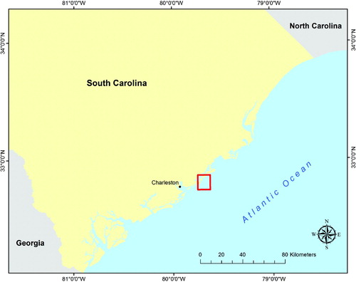
The coastal zone of South Carolina (SC) is situated within the South Atlantic Bight, an arcuate 1200 km stretch of coastline characterized by a wide, shallow continental shelf on the trailing edge of the tectonically stable North American Plate (Hayes, Citation1994). Along the coast of southern and central South Carolina, the focusing of tides in this wide, curved embayment increases the amplification of tidal range and decreases the impact of deep water wave energy, producing a depositional, mixed-energy setting that gives rise to a class of drumstick-shaped barrier islands separated by ebb-dominated tidal inlets (Davis & Fitzgerald, Citation2004). The Caper's Inlet Quadrangle, situated approximately 24 km north-east of the city of Charleston, SC, is representative of this depositional setting, containing sections of three barrier islands with two ebb-dominated tidal inlets separating them (; see Luciano & Harris, 2012).
Figure 1. Location map of the Capers Inlet Quadrangle, South Carolina study area.
The study area encompasses a total of 166 km2, with topography and bathymetry ranging between −15 m offshore to approximately +5 m in upland areas. The geomorphology and coastal dynamics of the area have been characterized in existing work (Fitzgerald, Citation1984; Gaudiano & Kana, Citation2001; Hayes, Citation1994). However, this research is the first to consider the impacts of underlying stratigraphy on geomorphic evolution in the nearshore, offshore, and terrestrial environments of this area, coupled with modern near-surface sedimentation. The maps reflect this focus by incorporating high-resolution sidescan sonar and subbottom profiler data together with existing geomorphic data in order to better understand the relationship between aboveground geomorphology, surficial sediment distribution, and shallow geology. This mapping effort represents a departure from traditional USGS quadrangle mapping in that it includes terrestrial data as well as information obtained through marine geophysical surveys.
2. Data and methodology
Project maps were constructed using existing topographic maps, specifically a NOAA/NGDC coastal relief model, in combination with original geophysical and ground-truth data. Data collected and analyzed for the geologic map include: (1) high-resolution sidescan backscatter sonar surveys in all backbarrier and offshore marine areas, (2) high-resolution chirp subbottom profiler surveys of the same marine areas, (3) terrestrial ground-penetrating radar (GPR) surveys, (4) vibracore sampling on barrier island ridges, (5) surficial seafloor sediment grabs, and (6) existing deep core data.
2.1 Geophysical data acquisition
Geophysical surveying was conducted aboard the College of Charleston Department of Geology and Environmental Geoscience's survey vessel Pioneer, using Hypack™ software for navigation. Sidescan sonar imaging was acquired using a Klein 3900 model sidescan sonar (900 kHz), and an EdgeTech 216S Chirp portable subbottom profiler (2–10 kHz swept signal) was used to collect shallow stratigraphic data. Water depths ranged from <0.5 m over oyster reef at high spring tide (tidal elevations in the range of 2.0 to 2.2 m versus mean tidal levels of 1.5 m) to just under 15 m in the extreme southeastern section of the study area.
2.2 Geophysical data processing
Sidescan sonar and subbottom profiler data were processed using SonarWiz Map v. 4.0.082 software. Post-processed sidescan sonar data were mosaicked and imported into ArcGIS v. 9.3 to allow for interpretation of surficial sediment distribution patterns using sonar backscatter data. In this study area, nine distinct seafloor classifications were identified according to sediment type (e.g. sand, shell hash, mud) using a classification scheme based loosely on seafloor imaging work performed in the Gulf of Maine (Barnhard, Kelley, Dickson, & Belknap, Citation1998).
High-resolution chirp subbottom profiler data were used to map the shallow stratigraphy of the area. The seafloor, first seismic reflector (base of recent sediments), and the base of the Quaternary sediments were digitized along each trackline by identifying reflectors in the subsurface, and thicknesses of recent and Quaternary sediments were exported. These thickness ‘z’ values were then imported into ArcGIS v.9.3 as point data and used to create a series of isopach (sediment thickness) maps for modern sediments and the Quaternary deposits.
3. Discussion
The final maps provide a visual and digital depiction of the data collected and an interpretation of the project's findings. The data presented illustrate that the surficial seafloor in this area is sedimentologically variable, with areas of mud, sand, and shell hash in distinct patterns and locations related to inlet and coastal dynamics.
3.1 Linear ripple scour depressions
The most notable features identified are linear ripple scour depressions, shore-perpendicular shell hash-rich zones extending into the nearshore close to Dewees and Capers Islands. Material supplying the surficial shell hash features likely originates from re-worked Holocene and Pleistocene deposits (Hayes, Citation1994). These features have been described in other nearshore coastal settings that display vastly different tidal and wave regimes, including the East, West, and Gulf coasts of the United States, and New Zealand (Coco, Murray, & Green, Citation2007; Thieler, Pilkey, Cleary, & Schwab, Citation2001), and are typically on the order of several meters in width to tens of meters in length. In the study area a series of scour depressions consisting of a coarse shell hash extend offshore to the −10 m isobath, where the shell material in several of the larger linear ripple scour depressions becomes increasingly dispersed as water depth increases (). Fanning or ‘feathering’ into the sand units becomes more apparent in depths farther from the landward terminus. There is a strong decrease in shell hash content from the southwest along the coast to the northeast, where mud is prevalent, indicating an overall shift in sediment source and distribution.
Figure 2. Bedform features located near the −10 m bathymetric contour (in yellow). Bathymetry derived from 1958 NOAA hydrographic data.
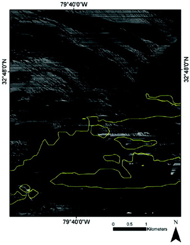
The shape and orientation of these features suggest that water depth and associated bottom currents may play a role in the distribution of surficial sediments in this area, resulting in a sweeping of sediment landward at the expense of the offshore edge of the shell bedform. Sidescan sonar data also show the presence of areas of fine-grained mud on the updrift side of these features, which corresponds with conclusions made in other studies that the coarse shell hash composition of the bedforms induces turbulence close to the seafloor, favoring the entrainment and transport of fine-grained sediment into adjacent zones where turbulence and associated shear stresses are lower (Murray & Thieler, Citation2004). Repeated surveys will provide a better understanding of the formation and orientation of these seafloor features in this area of the coastline.
3.2 Shoreline erosion
Shoreline erosion rates of change dating back to 1875 (Harris, Citation2000; Harris et al., Citation2005; Harris, Wright, Fuqua, & Tinker, Citation2009) can be used as a reliable indicator of the composite accretionary and erosional trends of South Carolina's coastline over a time span of 100+ years and have been added to the sidescan sonar map to provide more information pertaining to areas that have undergone long-term shoreline fluctuation. Historic shoreline change trends vary throughout the region; however, certain areas along the shoreface of Capers Island and northern Dewees Island have experienced a higher overall rate of erosion than the Isle of Palms or backbarrier areas. The overlay of these historical data with the sidescan sonar mosaic also illustrate that the linear scour depressions are situated in these areas directly offshore of southern Capers and central and southern Dewees Island that have experienced the highest rate of historical shoreline change in the study area.
Although the formation and distribution of linear ripple scour depressions may be controlled by alongshore currents and associated oceanographic processes, it is possible that sediment transport processes and differential erosion potentially impact the development of these features. In the Capers Inlet Quadrangle, their presence in the nearshore adjacent to Capers and Dewees may relate to the higher historical shoreline change rates and corresponding patterns of erosion observed on the southern ends of both islands.
3.3 Shallow stratigraphy
Isopach maps constructed using subbottom profiler data show thicknesses of modern and Quaternary age materials in the shallow subsurface. A series of paleochannels, one of which extends to −28 m MSL, are identified in the nearshore and backbarrier. The deepest of these is present in the shallow stratigraphy underlying Copahee Sound, where it extends into modern-day Dewees Inlet. A shifting in the position of Dewees Inlet is not evident on the northern end of the Isle of Palms, whereas the recent (<200 years) shifting of Capers Inlet southward has been documented in the stratigraphy of northern Dewees Island (Tye, Citation1984). Much of the offshore is characterized by a thin layer of active seafloor (Quaternary) material overlying Tertiary-aged stratigraphy. Tertiary-aged material was found outcropping in the inlets and backbarrier.
Onshore, estimated age dates for the Holocene barrier islands and Pleistocene upland were determined using OSL (Optically Stimulated Luminescence) dating techniques on a series of quartz and feldspar-rich sediment samples obtained through shallow vibracoring. The approximate ages of each sample (), taken from the most landward ridges on two of the barrier islands, indicate that Capers (CI-1 and CI-16) and Dewees Island (DI-1) are quite young, at 1830 ± 55, 790 ± 30, and 750 ± 25 years, respectively. A sample from a core collected just outside the extent of the quadrangle study area in the Pleistocene upland dates to 116,710 years ± 3380 (UP-1). Based on other stratigraphic research recently undertaken in the area (Willis, Citation2002), we classify these deposits in the upland area as belonging to the Silver Bluff stratigraphic unit. Map units identified from cores previously taken on the three barrier islands (Katuna, Citation1998) include the Ashley Formation (Oligocene), overlain by the Marks Head Formation (Miocene), undifferentiated Pleistocene, and Holocene sediments.
Table 1. Quartz OSL and feldspar IRSL ages from the Caper's Inlet Quagrangle.
3.4 Conclusion
Terrestrial portions of the Caper's Inlet Quadrangle include areas, namely the northern section of the Isle of Palms and Dewees Island, which are populated and significant to the state's coastal-based tourism industry. These barrier islands are primarily composed of sand barrier ridges <2000 years old and modern marshes, with current ridge positions providing context to paleo-shoreline locations.
Loss of sediment through the erosion of dynamic shoreface areas is an issue in the region, and management responses including beach renourishment have repeatedly been used to protect coastal property. Maps illustrating surficial geomorphology are therefore useful to coastal scientists and managers seeking to understand sediment transport patterns and locate areas that may provide renourishment-quality sediments. Overall, gaining a better understanding of the surficial and stratigraphic geology of the area is an important facet of balancing coastal management demands that include residential property rights, tourism, and conservation.
Supplemental Material
Download PDF (49 MB)Acknowledgements
This project was funded through the USGS EDMAP Program (award #G09AC00123), the College of Charleston, and the Graduate School of the College of Charleston. Thanks are owed to Chesapeake Technology for assistance and advice concerning geophysical data processing using SonarWiz Pro software, as well as Shannon Mahan and the US Geological Survey Luminescence Dating Lab (Denver, CO) for assistance with OSL sediment dating in 2010. We would like to express our appreciation to Kacey Johnson, Jennifer McCarthey Tyrell, Pete Meier, and Christy Fandel for assistance in the field. Thank you to Lori Sheridan-Wilson, Phil Maier, and Dave Kynoski for granting permission to collect GPR and vibracore data on Dewees Island, Capers Island, and the Isle of Palms.
Software
High-resolution marine geophysical data were processed using Chesapeake Technology's SonarWiz Map v.4.0.082 software, and imported into the software from collected XTF (sidescan sonar) and SEG-Y data files (subbottom profiler). After gain settings were identified and set and bottom-tracking was completed, sidescan data were compiled into a mosaic, and both sidescan and subbottom profiler data were imported into ArcGIS v.9.3. Data processing involved setting a filter to counteract the impacts of swell recorded in the data collected offshore, digitizing the seafloor, and identifying shallow stratigraphic features and boundaries. Ground-penetrating radar (GPR) data were processed using RadExplorer v.1.41 software. All geophysical data collected and processed for this project are organized and stored in an ArcGIS v.10.0 database. CanvasX™ was used to compile the map and create cartographic symbology.
References
- Barnhard, W. , Kelley, J. , Dickson, S. , and Belknap, D. , 1998. Mapping the Gulf of Maine with sidescan sonar: A new bottom-type classification for complex seafloors , Journal of Coastal Research 14 (1998), pp. 646–659.
- Coco, G. , Murray, A. , and Green, M. , 2007. Sorted bed forms as self-organized patterns: 1. Model development , Journal of Geophysical Research 112 (2007), p. F03015, (doi:10.1029/2006JF000665).
- Davis, R. , and Fitzgerald, D. , 2004. Beaches and Coasts . Wiley-Blackwell; 2004. pp. 156–161.
- Fitzgerald, D. , 1984. Interactions between the ebb-tidal delta and landward shoreline: Price Inlet, South Carolina , Journal of Sedimentary Research 54 (1984), pp. 1303–1318.
- Gaudiano, D. , and Kana, T. , 2001. Shoal bypassing in mixed energy inlets: Geomorphic variables and empirical predictions for nine South Carolina inlets , Journal of Coastal Research 17 (2001), pp. 280–291.
- Harris, M. (2000). Influence of a complex geologic framework on Quaternary coastal evolution: an example from Charleston, South Carolina (PhD thesis). University of Delaware..
- Harris, M. , Gayes, P. , Kindinger, J. , Flocks, J. , Krantz, D. , and Donovan, P. , 2005. Quaternary geomorphology and modern coastal development in response to an inherent geologic framework: an example from Charleston, South Carolina , Journal of Coastal Research 21 (2005), pp. 49–64, (doi:10.2112/00-015.1).
- Harris, M. , Wright, E. , Fuqua, L. , and Tinker, T. , 2009. Comparison of shoreline erosion rates derived from multiple data types: Data compilation for legislated setback lines in South Carolina (USA) , Journal of Coastal Research, Special Issue 56 (2009), pp. 1224–1228.
- Hayes, M. , 1994. The Georgia Bight barrier system . Springer-Verlag; 1994. pp. 233–304.
- Katuna, M. , 1998. Central South Carolina coast barrier Island drill holes . Charleston, SC: College of Charleston; 1998.
- Luciano, K.E., & Harris, M.S. (2012). Published Map. In Luciano, K.E., and Harris, M.S. (2012) Surficial geology and geophysical investigations of the Capers Inlet, South Carolina (USA) 7.5-Minute Quadrangle, Journal of Maps, v2012, 1–6..
- Murray, A. , and Thieler, E. , 2004. A new hypothesis and exploratory model for the formation of a large-scale inner-shelf sediment sorting and “rippled scour depressions” , Continental Shelf Research 24 (2004), pp. 295–315, (doi:10.1016/j.csr.2003.11.001).
- Prescott, J.R., & Hutton, J.T. (1994). Cosmic ray contributions to dose-rates for luminescence and ESR dating: large depths and long-term time variations. Radiation Measurements, 23, 497–500..
- Thieler, E. , Pilkey, O. , Cleary, W. , and Schwab, W. , 2001. Modern sedimentation on the shoreface and inner continental shelf at Wrightsville Beach, North Carolina, USA , Journal of Sedimentary Research 71 (2001), pp. 958–970, (doi:10.1306/032101710958).
- Tye, R. , 1984. Geomorphic evolution and stratigraphy of Price and Capers Inlets, South Carolina , Sedimentology 31 (1984), pp. 655–674, (doi:10.1111/j.1365-3091.1984.tb01229.x).
- Willis, R. (2002). Genetic stratigraphy and geochronology of last interglacial shorelines on the central coast of South Carolina (Master's thesis). Louisiana State University..