Abstract
The External Ligurian Units in western Monferrato (NW-Italy) have been always described as an undifferentiated chaotic complex. This map, at 1:10,000 scale, describes in detail the tectono-stratigraphic setting of these Units in the sector of the Alps–Apennines junction. Here, the External Ligurian Units represent the northwestern prolongation of the Northern Apennines and consist of a Late Cretaceous chaotic succession represented by the Argille varicolori and the overlaying Monte Cassio Flysch. The late Eocene–Miocene episutural succession of the Tertiary Piedmont Basin rests unconformably on the External Ligurian Units. The mapped crosscutting relationships between stratigraphic unconformities and faults allow us to describe a complex tectono-stratigraphic setting that is the product of four tectonic stages. Layer-parallel extension related to Late Cretaceous–early Eocene deformation occurred in the internal sector of the Alpine accretionary wedge and is preserved within the External Ligurian Units which is sealed by the late Eocene deposits of the Tertiary Piedmont Basin. The unconformity at the base of the Oligocene succession records the drowning of shelf sediments controlled by NW-striking left-lateral transtensive faulting. A WNW-striking and NE-verging thrust superposes the External Ligurian Units onto the late Eocene–Oligocene deposits and it is sealed by the gravitational emplacement of late Oligocene Polygenetic argillaceous breccias. Both the WNW-striking thrust and the Polygenetic argillaceous breccias are cut by NW-striking right-lateral transpressive faults that are, in turn, sealed by the Tortonian unconformity.
1. Introduction
The understanding of the tectono-stratigraphic evolution of a sector is strictly related to the outcrop condition. Good outcrop condition and excellent rock exposures attract geologists with different backgrounds facilitating a complete understanding of the geology of that sector. On the contrary, a sector with poor rock exposures and very low outcrop percentage is commonly not or poorly studied with a consequent lack of geological informations on its tectono-stratigraphic evolution. In most of these cases, detailed geological mapping represents the most useful approach in covering the lack of geological information, thus in better understanding the tectono-stratigraphic evolution of a sector. This is the case of the western Monferrato in NW Italy (), where the Late Cretaceous–Eocene unmetamorphosed External Ligurian Units (i.e. ‘undifferentiated complex’ sensu Bonsignore et al., Citation1969; ‘la Pietra chaotic complex’ sensu Dela Pierre, Piana, Fioraso, et al., Citation2009) have never been mapped and studied in detail because of the poor outcrop condition and the extensive unconformable cover of the late Eocene–late Miocene episutural succession of the Tertiary Piedmont Basin.
In this paper, we present a new geological map (1:10,000 scale; see supplementary content) of a sector of the westernmost Monferrato (South of Lauriano village) that, although covering a limited area, represents the northwesternmost sector of the Northern Apennines where the External Ligurian Units crop out. This sector is also crucial for better understanding of both the Late Cretaceous–Eocene tectono-stratigraphic evolution of the internal sectors of the Alpine accretionary wedge and the relationships between the External Ligurian Units and the overlying Tertiary Piedmont Basin succession in the sector of Alps–Apennines junction (e.g. ‘Ligurian knot’ of Laubscher et al., Citation1992; Mosca, Polino, Rogledi, & Rossi, Citation2010; Rossi, Mosca, Polino, Rogledi, & Biffi, Citation2009; Schumacher & Laubscher, Citation1996).
2. Methods
The geological map (see supplementary content) has been produced from about three years (2009–2011) of field work by means of geological mapping at 1:10,000 scale and detailed stratigraphic and structural analyses. Areas of particular complexity or interest have been mapped at 1:1000 scale detail (e.g. North of Moglietto, South of ‘la Giustizia’, West of Novarese and South of ‘la Pietra’; see Geological Map in the supplementary content). Progressive acquisition and interpretation of data have been documented in the attached geological-structural map at 1:10,000 scale using sections 156,040 and 157,010 of the topographic map ‘CTR – Carta Tecnica Regionale, Regione Piemonte’. The map includes a regional-structural scheme, three geological cross sections, and a stratigraphic column describing the characteristics of the lithostratigraphic succession.
3. Regional setting
The Tertiary Piedmont Basin ( is a large episutural basin developed, since late Eocene onward, in the internal sector of the Western Alps (e.g. Castellarin, Citation1994; Gelati & Gnaccolini, Citation1988; Mosca et al., Citation2010; Mutti et al., Citation1995; Roure, Bergerat, Damotte, Mugnier, & Polino, Citation1996). This basin has been unconformably deposited on the Alps–Apennines junction (e.g. ‘Ligurian knot’ of Laubscher et al., Citation1992; Schumacher & Laubscher, Citation1996) that corresponds to a complex tectonic jigsaw including the buried metamorphic Western Alpine units, the SE-verging front of the South Alpine thrust system, and the northeast-verging External Ligurian Units of the Northern Apennines (e.g. Biella, Gelati, Lozej, Rosisi, & Tabacco, Citation1988; Biella, Polino et al., Citation1997; Castellarin, Citation1994; Laubscher et al., Citation1992; Mutti et al., Citation1995; Piana, Citation2000; Mosca et al., Citation2010; Molli et al., Citation2010; Roure et al., Citation1996; Schumacher & Laubscher, Citation1996). The External Ligurian Units consist of a non-metamorphosed succession deposited on the ocean-continent transition zone (OCT) of the rifted Adria continental margin (e.g. Marroni, Meneghini, & Pandolfi, Citation2010 and reference therein). They are classically differentiated from the Internal Ligurian Units ( that represent an ‘incomplete’ ophiolite sequence and overlying Jurassic-Eocene sedimentary cover deposited on the Jurassic oceanic crust of the Ligurian Ocean (e.g. Abbate et al., Citation1986; Castellarin, Citation1994; Dilek & Furnes, Citation2011; Elter, Citation1975; Festa et al., Citation2010; Lucente & Pini, Citation2003; Marroni, Molli, Montanini, & Tribuzio, Citation1998; Marroni, Molli, Ottria, & Pandolfi, Citation2001, Marroni et al., Citation2010; Molli et al., Citation2010; Vezzani, Festa, & Ghisetti, Citation2010).
Figure 1. Structural sketch map (A) of the northwestern Italy (modified from Bigi, Cosentino, Parotto, Sartori, & Scandone, Citation1983; Codegone et al., Citation2012; Mosca et al., Citation2010). (B) Location of .
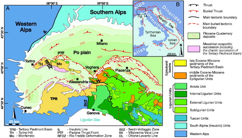
The Torino Hill and Monferrato, which are separated by the NW-striking Rio Freddo Deformation Zone (sensu Piana & Polino, Citation1995), represent the northern part of the Tertiary Piedmont Basin (. The Torino Hill succession rests unconformably on a metamorphic basement and Mesozoic sedimentary cover of South Alpine pertinence (Festa et al., Citation2005; Festa, Dela Pierre, et al., Citation2009; Mosca et al., Citation2010), buried at a depth of 2–3 km (Bonsignore et al., Citation1969; Miletto & Polino, Citation1992; Mosca et al., Citation2010). The Monferrato succession unconformably overlies the Cretaceous-to lower Eocene, non-metamorphic undifferentiated Ligurian units (Bonsignore et al., Citation1969). Its magnetic basement is buried at a depth of 8–10 km (Cassano, Anelli, Fichera, & Cappelli, Citation1986; Miletto & Polino, Citation1992).
Although Elter, Elter, Sturani, and Weidmann (Citation1966) and Bonsignore et al. (Citation1969) suggested that part of the Ligurian Units of Monferrrato (i.e. the ‘Lauriano complex’ of Albian–Cenomanian age and the ‘Monteu da Po Flysch’ of Maastrichthian age) should be correlated with part of the ‘basal complex’ and the Monte Cassio Flysch of the External Ligurian Units, respectively, these units have been commonly described and mapped as an undifferentiated chaotic complex (‘undifferentiated complex’ sensu Bonsignore et al., Citation1969; ‘la Pietra Chaotic Complex’ sensu Dela Pierre, Piana, Boano, Fioraso, & Forno, Citation2003; Dela Pierre, Piana, Fioraso, et al., Citation2003) of Late Cretaceous–middle Eocene age. Only Sacco (Citation1935), in the first edition of the Geological Map of Italy, and Beets (Citation1940) distinguished in map varicolored shale and a calcareous flysch succession but they did not correlate in detail these units with those of the Northern Apennine succession.
By contrast, the late Eocene–late Miocene succession of the northern part of the Tertiary Piedmont Basin has been described (e.g. Clari, Proto Decima, Ricci, & Sampò, Citation1987; Dela Pierre, Piana, Fioraso, et al., Citation2003; Dela Pierre, Festa, & Irace, Citation2007; Festa, Dela Pierre, et al., Citation2009; Festa, Citation2011) and mapped in detail over recent decades (Piana, Citation2000; Dela Pierre, Piana, Boano, et al., Citation2003; Festa, Boano, et al., Citation2009) allowing the subdivision of the tectono-stratigraphic evolution of the Torino Hill and Monferrato into four contractional faulting stages dated as Rupelian, Burdigalian, Serravallian, and Messinian, respectively (Dela Pierre, Piana, Boano, et al., Citation2003; Dela Pierre, Piana, Fioraso, et al., Citation2003; Dela Pierre, Festa, & Irace, Citation2007; Festa et al., Citation2005; Festa, Boano, et al., Citation2009; Festa, Dela Pierre, et al., Citation2009; Festa, Citation2011; Piana, Citation2000).
4. Data
4.1 Stratigraphy
The stratigraphic succession () is characterized by the unconformable deposition of the late Eocene–middle Miocene succession of the Tertiary Piedmont Basin onto the Cassio Unit of the Late Cretaceous External Ligurian Units, formerly described as ‘undifferentiated complex’ (sensu Bonsignore et al., Citation1969) and ‘la Pietra chaotic complex’ (sensu Dela Pierre, Piana, Fioraso, et al., Citation2003).
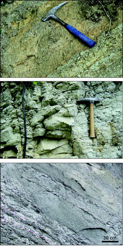
The lower part of the Cassio Unit consists of the chaotic succession of the Late Cretaceous (Santonian–Campanian) Argille varicolori (Varicolored Scaly clays). The latter, correspond to the upper part of the ‘basal complex’ Auct. of the External Ligurian Units (e.g. Codegone, Festa, Dilek, & Pini, Citation2012; Marroni et al., Citation2010). The Argille varicolori are characterized by highly disrupted and chaotic rocks lacking layer-continuity and displaying a block-in-matrix fabric (. The matrix consists of alternating cm-dm layered varicolored (mainly gray, red and purple) deformed beds of clay and shale (. The blocks, which represent the product of intense disruption and fragmentation of the originally coherent succession, consist of Upper Cretaceous limestone, sandstone and manganiferous siltstone. These blocks are of intra-formational origin, thus the Argille varicolori represent a broken formation (sensu Hsü, Citation1968; see also Festa, Dilek, Pini, Codegone, & Ogata, Citation2012). A tens of meters thick and hundreds of meters long lenticular body of Campanian conglomerates (‘Salti del Diavolo’ conglomerates Auct.) is also enveloped within the Argille varicolori ( and C). The occurrence of not-mappable slices of Cenomanian(?)–early Campanian Scabiazza sandstones and early Cretaceous Palombini shales, tectonically included in the Argille varicolori along the thrust shear zones (see below), suggests that such lithostratigraphic units represent the stratigraphic base of the Argille varicolori () as well as in Northern Apennines (e.g. Marroni et al., Citation2010 and reference therein).
Figure 2. Stratigraphic columns of the External Ligurian Units, Epiligurian Units and Tertiary Piedmont Basin succession in Western Monferrato and Northern Apennines. Modified after Marroni et al. (Citation2010) and Codegone et al. (Citation2012).
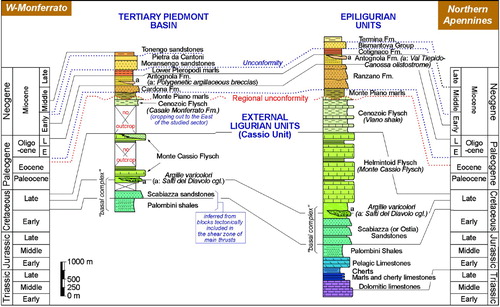
Figure 3. (A) Highly disrupted block-in-matrix fabric of the Argille varicolori characterized by intense fragmentation of the originally coherent succession (NE of Moglietto); (B) Polished hand sample of the matrix of the Argille varicolori of showing a layer-parallel extensional fabric characterized by pinch-and-swell structures and boudinage of the shaly layers; (C) Detail of the ‘Salti del Diavolo’ conglomerates (SE of Novarese); (D) Alternating calcareous turbidite and gray marl and clay of the Monte Cassio Flysch (NNE of Torrione); (E) Calcareous marl alternating with (F) light brown-yellowish hybrid turbiditic calcarenite of the Monte Cassio Flysch (NE of Moglietto).
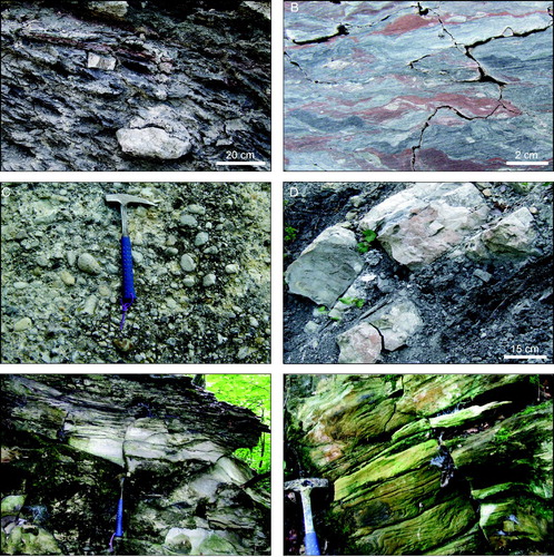
The Argille varicolori grade upward to the late Campanian(?)–Maastrichtian Monte Cassio Flysch that consists of a thick (up to 400 m) and highly disrupted succession of calcareous turbidite ( and ) alternating with grayish and light brown-yellowish hybrid calcarenite ( and grayish micritic limestone, decimeters to about one meter thick, and up to decimeter thick horizons of gray marl and clay. The External Ligurian Units are followed unconformably by the late Eocene hemipelagic Monte Piano marls ( and 4A) that represent the stratigraphic base of the Tertiary Piedmont Basin succession (see also Dela Pierre, Piana, Fioraso, et al., 2009; Festa, Boano, et al., Citation2009). The shallow water coarse-grained sediments of the Cardona Formation (early Oligocene; see rest unconformably on the Monte Piano marls and grade upward to the slope fine-grained deposits of the Antognola Formation (late Oligocene–Aquitanian; see and siliceous marls of the Lower Pteropodi marls (early Burdigalian; see (see also Clari et al., 1987; Dela Pierre, Piana, Fioraso, et al., 2009; Festa, Boano, et al., Citation2009).
Figure 4. (A) Typical aspect of the gray calcareous hemipelagic Monte Piano marls (South of C. Valentino); (B) Alternating coarse-grained yellowish sandstone and burrowed gray-greenish mudstone of the Cardona Formation (ENE of C. Micheli); (C) Alternating yellowish sandstone and silty marl of the Antognola Formation (West of Piazzo); (D) Alternating brown-reddish silicified marl and silty marl of the Lower Pteropodi marls (West of Valletta); (E) Highly disordered block-in-matrix fabric of the Polygenetic argillaceous breccias showing differently shaped blocks of limestone, sandstone, marl and siltstone that float with random distribution in a brecciated shaly matrix (NW of Gerbole). (F) Polished surface of a hand sample of the Polygenetic argillaceous breccias showing the isotropic texture of the matrix (about 1 km to the NE of Moglietto).
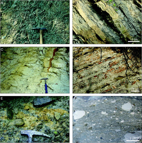
Polygenetic argillaceous breccias of late Oligocene age, first described in Monferrato, have been differentiated within the ‘undifferentiated complex’ sensu Bonsignore et al. (Citation1969) or ‘la Pietra Chaotic Complex’ sensu Dela Pierre, Piana, Fioraso, et al. (Citation2003). These breccias ( and E and F) consist of a highly disrupted polygenetic assemblage of both native and exotic blocks (centimeters to decimeters in size) sourced from the ‘basal complex’ Auct. (i.e. Argille varicolori, Scabiazza sandstones, Palombini shales), older stratigraphic succession (Maiolica limestones and reddish limestone) of the External Ligurian Units, Monte Cassio Flysch, and late Eocene – late Oligocene Tertiary Piedmont Basin succession (Monte Piano marls, Cardona Formation and Antognola Formation). The blocks are randomly distributed and oriented within a brecciated, almost isotropic, shaly matrix ( and ). The Polygenetic argillaceous breccias correspond to an upper Oligocene sedimentary mélange (i.e. olistostrome).
The Antognola Formation is followed unconformably by the Sciolze Group (sensu Festa, Boano, et al., 2009, Festa, Dela Pierre, et al., Citation2009) that includes shallower and coarser shelf deposits of the Moransengo sandstones (Burdigalian p.p.–Langhian p.p.; see Clari, Dela Pierre, Novaretti, & Timpanelli, Citation1994, Clari, Dela Pierre, Novaretti, & Timpanelli, Citation1995; see and the whitish calcareous marls ( of late Burdigalian age, corresponding to the Pietra da Cantoni Formation (see also Dela Pierre, Piana, Fioraso, et al., 2009; Festa, Boano, et al., Citation2009).
Figure 5. (A) Alternating yellowish microconglomerate and gray marl of the Moransengo sandsones (SE of C. Micela); (B) Whitish calcareous marls of the Pietra da Cantoni (South of Scalaro); (C) Light gray to whitish hybrid arenite and sandstone of the Tonengo sandstones (East of Pareglio).
The Langhian succession is introduced by a regional unconformity bounding at the base of whitish hybrid arenite ( of the Tonengo sandstones (Pino Torinese Group sensu Festa, Boano, et al., 2009, Festa, Dela Pierre, et al., Citation2009) that represent outer platform deposits (see also Clari et al., Citation1994).
Alluvial deposits of Holocene to Quaternary age drape the base of the foothills.
4.2 Tectonic setting
The tectonic setting is described in the following through the crosscutting relationships between faults and stratigraphic unconformities, or between different mesoscale deformation features.
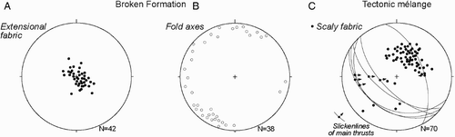
The unconformity at the base of the late Eocene Monte Piano marls constrains to the Late Cretaceous–early Eocene the deformation affecting the External Ligurian Units. This deformation is not shown at map scale because of the overprinting of later deformation (see below). However, at the mesoscale the Argille varicolori are characterized by a layer-parallel extensional fabric ( and ), mainly WNW-striking (, resulting from progressive bedding-parallel boudinage typical of broken formations (sensu Hsü, Citation1968; see also Festa et al., Citation2012). Pinch-and-swell structures and boudinage are mainly asymmetric ( and define a planar alignment mainly along WNW–ESE direction. Elongated intra-formational blocks show irregular flat-to ellipsoidal shape corresponding to different degrees of extension accompanied by R and R' shears ( and ). Decimeters wide, ESE-verging noncylindrical flattened and intralayered asymmetrical folds uniformly occur in the Argille varicolori (. These are commonly rootless and transposed with mainly NNE-striking fold axes (. The unconformity at the base of late Eocene Monte Piano marls constrains to Late Cretaceousearly Eocene the first tectonic stage preserved in the studied sector (see Geological Sections 1–3 in the supplementary content).
Figure 6. (A) Polished hand sample of Argille varicolori showing asymmetric boudinage related to extensional shearing and in situ disruption of alternating layers of sandstone (white) and shale (red and gray) (East of Gerbole). White lines indicate R-shears; (B) Polished surface of a hand sample showing R-shears (see dashed lines) transecting the varicolored shaly layers of the Argille varicolori (North of Piazzo); (C) Decimeters wide, intralayered flattened fold in the Argille varicolori (ENE of Gerbole); (D) Mesoscale left-lateral transtensive fault showing a ‘tulip type’ flower structure in the Monte Piano marls (South of Piazzo); (E) Plan view of a mesoscale left-lateral transtensive fault in the Monte Piano marls (South of Piazzo). The photograph on the left is schematically redrawn on the right of the figure. Mesoscale data of the fault are also shown in the structural diagram (Schmidt net, lower hemisphere); (F) ‘Structurally ordered’ block-in-matrix fabric within the Argille varicolori tectonic mélange close to the main thrust (SW of la Pietra). The fabric is related to NE-verging reverse shear (red lines) and it is characterized by elongated extra-formational blocks embedded in a matrix pervasively affected by scaly fabric and S-C features; (G) Polished surface of a hand sample of the Argille varicolori tectonic mélange showing the reverse shear surfaces and related R-shear, and a pervasive scaly fabric (about 1 km to the NE of Moglietto).
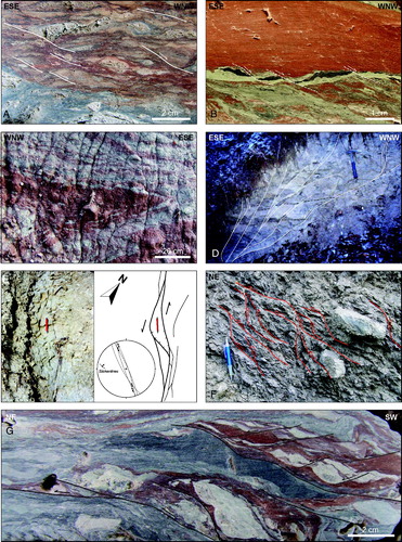
Figure 7. Mesoscale data (Schmidt net, lower hemisphere) of the extensional scaly fabric (A) and fold axes (B) of the Argille varicolori broken formation, and the scaly fabric (C) of the Argille varicolori tectonic mélange.
The unconformity at the base of the Cardona Formation records the drowning of Early Oligocene shelf sediments controlled by NW-striking left-lateral transtensive faults (see also Dela Pierre, Piana, Fioraso, et al., 2003; Festa et al., 2005, Festa, Dela Pierre, et al., Citation2009; Piana, Citation2000). These faults, that are well preserved at the mesoscale (, show meters-to tens of meters wide ‘tulip type’ flower structures such as, for example, along the NW-striking fault located to the South of Piazzo (. At regional scale, transtensive faulting defined localized NW striking pull-apart basins that controlled the drowning of early Oligocene sediments (see Dela Pierre, Piana, Fioraso, et al., 2003; Festa et al., 2005, Festa, Dela Pierre, et al., Citation2009; Mosca et al., Citation2010; Mutti et al., Citation1995; Piana, Citation2000; Rossi et al., Citation2009). The tectonic activity of these faults corresponds to the Rupelian tectonic stage of Piana (Citation2000) and Festa et al. (2005, Festa, Dela Pierre, et al., Citation2009).
The Cardona Formation (Oligocene p.p.) and the lower part of the Antognola Formation (late Oligocene–early Miocene) are overthrust by the Late Cretaceous External Ligurian Units (Monte Cassio Flysch and Argille varicolori) along a NW-striking and NE-verging thrust (see Geological Sections 1–3 in the supplementary content). SW and NE-dipping splays develop from the main thrust surface as in the sectors ESE of Novarese (see also Geological Section 3 in the supplementary content) and NNE of Moglietto (see also Geological Section 2 in the supplementary content), respectively. In this last sector, the NE and SE-dipping thrusts depict a NW-striking pressure ridge along which the Argille varicolori are pushed up (see Geological Section 2 in the supplementary content).
In the hanging wall of the main NE-verging thrust, the Argille varicolori are deformed by contractional shearing to form a narrow (up to tens of meters thick) NW-striking tectonic mélange ( and ). Shear deformation cuts and completely overprints the above described layer-parallel extensional fabric of the Argille varicolori (i.e, broken formation) forming a scale independent ‘structurally ordered’ (sensu Festa, Citation2011; Festa et al., Citation2012) block-in-matrix fabric (, and a pervasive scaly cleavage in the matrix (. Here, the Argille varicolori tectonically include blocks of both native (e.g. limestone, sandstone and manganiferous siltstone) and exotic origin (e.g. Early Cretaceous Palombini shales, Cenomanian(?)–early Campanian Scabiazza sandstones) wrenched from the ‘basal complex’, the older buried succession (Late Jurassic–Early Cretaceous Maiolica), late Campanian(?)–Maastrichtian Monte Cassio Flysch, and the late Eocene–Oligocene Tertiary Piedmont Basin succession.
The emplacement of the Polygenetic argillaceous breccias (see also Geological Section 1 in the supplementary content) constrains to the early part of late Oligocene the tectonic superposition of the External Ligurian Units onto the Tertiary Piedmont Basin succession. This data better details the late Chattian–pre late Burdigalian tectonic stage described in the literature (see Festa et al., 2005; Festa, Dela Pierre, et al., Citation2009; Piana, Citation2000), constraining the thrusting to the late Oligocene (i.e. Chattian).
Contractional deformation gradually decreases up to late Burdigalian times as suggested by the progressive decreasing of bedding dipping from the upper part of Antognola Formation (Aquitanian) to the Lower Pteropodi marls (early Burdigalian), Moransengo sandstones (Burdigalian p.p.–Langhian p.p.) and Pietra da Cantoni (late Burdigalian).
NW-striking right-lateral transpressive faults, cut both the thrusts (e.g. West of Mezzana, South of Piazzo) and the unconformity at the base of the Antognola Formation (e.g. East of Gerbole), respectively. These faults, that in some cases show typical horse tail termination (South of Piazzo), reactivated the pre-existing left-lateral transtensive faults (Dela Pierre, Piana, Boano, et al., 2003, Dela Pierre, Piana, Fioraso, et al., Citation2003; Festa et al., Citation2005, Festa, Boano, et al., 2009; Festa, Dela Pierre, et al., 2009; Piana, Citation2000). Out of the studied area, they are, in turn, sealed by the unconformity at the base of the Tortonian succession (see Dela Pierre, Piana, Boano, et al., Citation2003; Dela Pierre, Piana, Fioraso, et al., Citation2003; Festa et al., Citation2005; Festa, Boano, et al., 2009, Festa, Dela Pierre, et al., Citation2009; Piana, Citation2000).
5. Conclusions
Geological mapping has allowed us to map and describe in detail for the first time the tectono-stratigraphic setting of the External Ligurian Units of Northern Apennines in the sector of Alps–Apennines junction, western Monferrato. These units, that here represent the northwesternmost outcrop exposure of the External Ligurian Units of Northern Apennines, are unconformably covered by the episutural deposits of the late Eocene–late Miocene Tertiary Piedmont Basin. The crosscutting relationships between mapped faults and stratigraphic unconformities (), and different types of mesoscale deformation styles, allows us to define four main tectonic stages (i.e. Late Cretaceous–early Eocene, Rupelian, Chattian, Serravallian; ) recording the transition from accretionary stages to collisional deformation that occurred in the internal sector of the Alpine accretionary wedge.
Figure 8. Simplified geological-structural map of the investigated area showing the crosscutting relationships between different faulting stages (indicated with different colors) and stratigraphic unconformities (see text for a complete explanation). These relationships allow us to define four tectonic stages as summarized in the time column in the right part of the figure.

Software
The geological map has been digitalized using the ArcView 3.1 and then edited with Adobe Illustrator 10. This latter has also been used for the drawing of the geological sections and for the arrangement of the illustrations in this paper. Structural data have been processed and drawn using the software Faultkin vs. 5.5.0 (Richard W. Allmendinger, Copyright © 2001).
Supplemental Material
Download PDF (4.7 MB)Acknowledgements
We thank the Editor-in-Chief, M.J. Smith, and the Associate Editor K. Tanaka for their careful reviews of the map. We are indebted to Y. Dilek and P. Mosca for their insightful comments and suggestions that greatly helped us improve both the map and the text. A. Festa also thanks F. Dela Pierre, G. Fioraso, A. Irace and F. Piana for their support during early stages of field mapping.
Related Research Data
References
- Abbate, E. , Bortolotti, V. , Conti, M. , Marcucci, M. , Principi, G. , Passerini, P. , and Treves, B. , 1986. Apennines and Alps ophiolites and the evolution of the western Tethys , Memorie della Società Geologica Italiana 31 (1986), pp. 23–44.
- Beets, C. , 1940. Die Geologie des Westlichen Teiles der Berge von Monferrato zwischen Turin und Murinsengo , Ein Beitrag Zur Geologie des Nortapennis. Leidsche Geologische Mededeelingen 12 (1940), pp. 195–250.
- Biella, G. , Gelati, R. , Lozej, A. , Rosisi, P. M. , and Tabacco, I. , 1988. Sezioni geologiche nella zona limite Alpi occidentali–Appennino settentrionale ottenute da dati geofisici , Rendiconti della Società Geologica Italiana 11 (1988), pp. 287–292.
- Biella, G., Polino, R., de Franco, R., Rossi, P. M., Clari, P., Corsi, A., & Gelati, R. (1997). The crustal structure of the Western Po Plain: reconstruction from integrated geological and seismic data. Terra Nova, 9, 28–31..
- Bigi, G. , Cosentino, D. , Parotto, M. , Sartori, R. , and Scandone, P. , 1983. Structural Model of Italy: Geodynamic project, C.N.R , (1983), S.El.Ca. Firenze, scale 1:500,000, 9 sheets.
- Bonsignore, G. , Bortolami, G. , Elter, G. , Montrasio, A. , Petrucci, F. , Ragni, U. , Sacchi, R. , Sturani, C. , and Zanella, E. , 1969. Note Illustrative dei Fogli 56–57, Torino-Vercelli della Carta Geologica d'Italia alla scala 1:100,000 , Servizio Geologico d'Italia, Roma (1969), pp. 1–96.
- Cassano, E. , Anelli, L. , Fichera, R. , and Cappelli, V. , 1986. Pianura Padana: Interpretazione integrata di dati geofisici e geologici , 73° Congresso Società Geologica Italiana (1986), pp. 1–27.
- Castellarin, A. , 1994. "Strutturazione eo-mesoalpina dell'Appennino Settentrionale attorno al ‘nodo ligure’". In: Capozzi, R. , and Castellarin, A. , eds. 1994, Studi preliminari all'acquisizione dati del profilo CROP 1–1A La Spezia–Alpi orientali (pp. 99–108). Studi Geologici Camerti, Volume Speciale 1992/2: Camerino: Università degli Studi di Camerino.
- Clari, P. , Dela Pierre, F. , Novaretti, A. , and Timpanelli, M. , 1994. La successione oligo-miocenica del Monferrato occidenatale: confronti e relazioni con il Monferrato orientale e la Collina di Torino , Atti Ticinensi di Scienze della Terra (Serie Speciale) 1 (1994), pp. 191–203.
- Clari, P. , Dela Pierre, F. , Novaretti, A. , and Timpanelli, M. , 1995. Late Oligocene–Miocene sedimentary evolution of the criticals Alps/Apennines junction: The Monferrato area, Northwestern Italy , Terra Nova 7 (1995), pp. 144–152.
- Clari, P. , Proto Decima, F. , Ricci, B. , and Sampò, M. , 1987. Facies di piattaforma nell'Oligocene medio del Monferrato , Bollettino della Società Paleontologica Italiana 26 (1987), pp. 109–118.
- Codegone, G. , Festa, A. , Dilek, Y. , and Pini, G. A. , 2012. Small-scale Polygenetic mélanges in the Ligurian accretionary complex, Northern Apennines, Italy, and the role of shale diapirism in superposed mélange evolution in orogenic belts , Tectonophysics, 568–569 (2012), pp. 170–184, doi:10.1016/j.tecto.2012.02.003.
- Dela Pierre, F. , Festa, A. , and Irace, A. , 2007. Interaction of tectonic, sedimentary and diapiric processes in the origin of chaotic sediments: an example from the Messinian of the Torino Hill (Tertiary Piedmont Basin, NW Italy) , Geological Society of America Bulletin 119 (2007), pp. 1107–1119.
- Dela Pierre, F. , Piana, F. , Boano, P. , Fioraso, G. , and Forno, M. G. , 2003. Carta Geologica d'Italia alla scala 1:50,000 – Foglio 157 ‘Trino’ , (2003), ISPRA, Istituto Superiore per la Protezione e Ricerca Ambientale. Ed. Litografia Geda, Nichelino, 1 Sheet.
- Dilek, Y. , and Furnes, A. , 2011. Ophiolite genesis and global tectonics fingerprinting of ancient oceanic lithosphere , Geological Society of America Bulletin 123 (2011), pp. 387–411, doi:10.1130/B30446.1.
- Elter, P. , 1975. L'ensemble ligure , Le Bulletin de la Société Géologique de France 17 (1975), pp. 984–997.
- Elter, G. , Elter, P. , Sturani, C. , and Weidmann, M. , 1966. Sur la prolongation du domaine ligure de l'Apennin dans le Monferrat et les Alpes et sur l'origine de la Nappe de la Simme s.l. des Préalpes romandes et chablaisannes , Archives des Sciences de Genève 19 (1966), pp. 279–377.
- Festa, A. , 2011. "Tectonic, sedimentary, and diapiric formation of the Messinian melange: Tertiary Piedmont Basin (northwestern Italy)". In: Wakabayashi, J. , and Dilek, Y. , eds. Melanges: Processes of formation and societal significance . 2011, Geological Society of America Special Paper 480, 215–232. doi:10.1130/2011.2480(10).
- Festa, A. , Boano, P. , Irace, A. , Lucchesi, S. , Forno, M. G. , Dela Pierre, F. , Fioraso, G. , and Piana, F. , 2009. Carta Geologica d'Italia alla scala 1:50,000 – Foglio 156 ‘Torino Est’ , (2009), ISPRA, Istituto Superiore per la Protezione e Ricerca Ambientale. Ed. Litografia Geda, Nichelino, 1 Sheet.
- Festa, A. , Dela Pierre, F. , Irace, A. , Piana, F. , Fioraso, G. , Lucchesi, S. , Boano, P. , and Forno, M. G. , 2009. Note Illustrative della Carta Geologica d'Italia alla scala 1:50,000. Foglio 156 ‘Torino Est’ , (2009), ISPRA, Istituto Superiore per la Protezione e la Ricerca Ambientale, Litografia Geda, Nichelino, 1–143.
- Festa, A. , Dilek, Y. , Pini, G. A. , Codegone, G. , and Ogata, K. , 2012. Mechanisms and processes of stratal disruption and mixing in the development of mélanges and broken formations: Redefining and classifying mélanges , Tectonophysics, 568–569 (2012), pp. 7–24, doi:10.1016/j.tecto.2012.05.021.
- Festa, A. , Piana, F. , Dela Pierre, F. , Malusà, M. G. , Mosca, P. , and Polino, R. , 2005. Oligocene-Neogene kinematic constraints in the retroforeland basin of the Northwestern Alps , Rendiconti della Società Geologica Italiana (nuova serie) 1 (2005), pp. 107–108.
- Festa, A. , Pini, G. A. , Dilek, Y. , Codegone, G. , Vezzani, L. , Ghisetti, F. , Lucente, C. C. , and Ogata, K. , 2010. "Peri-Adriatic mélanges and their evolution in the Tethyan realm". In: Dilek, Y. , ed. Eastern Mediterranean geodynamics (Part II). International Geology Review . 2010, 52, (4–6), 369–406. doi:10.1080/00206810902949886.
- Gelati, R. , and Gnaccolini, M. , 1988. "Sequenze deposizionali in un bacino episuturale, nella zona di raccordo tra". In: Atti Ticinesi di Scienze della Terra Alpi ed Appennino settentrionale . Vol. 31. 1988, 340–350.
- Hsü, K. J. , 1968. Principles of mélanges and their bearing on the Franciscan-Knoxville Paradox , Geological Society of America Bulletin 79 (1968), pp. 1063–1074.
- Laubscher, H. P. , Biella, G. C. , Cassinis, R. , Gelati, R. , Lozej, A. , Scarascia, S. , and Tabacco, I. , 1992. The collisional knot in Liguria , Geologische Rundschau 81 (1992), pp. 275–289.
- Lucente, C. C. , and Pini, G. A. , 2003. Anatomy and emplacement mechanism of a large submarine slide within the Miocene foredeep in the Northern Apennines, Italy: A field perspective , American Journal of Science 303 (2003), pp. 565–602.
- Marroni, M. , Meneghini, F. , and Pandolfi, L. , 2010. Anatomy of the Ligure-Piemontese subduction system: Evidence from Late Cretaceous–middle Eocene convergent margin deposits in the Northern Apennines, Italy , International Geology Review 52 (2010), pp. 1160–1192.
- Marroni, M. , Molli, G. , Montanini, A. , and Tribuzio, R. , 1998. The association of continental crust rocks with ophiolites (northern Apennine, Italy): implications for the continent–ocean transition , Tectonophysics 292 (1998), pp. 43–66.
- Marroni, M. , Molli, G. , Ottria, G. , and Pandolfi, L. , 2001. Tectono-sedimentary evolution of the External Liguride units (Northern Apennines, Italy): insight in the precollisional history of a fossil ocean–continent transition zone , Geodinamica Acta 14 (2001), pp. 307–320.
- Miletto, M. , and Polino, R. , 1992. A gravity model of the crust beneath the Tertiary Piedmont Basin (northwestern Italy) , Tectonophysics 212 (1992), pp. 243–256.
- Molli, G. , Crisipini, L. , Malusà, G. M. , Mosca, P. , Piana, F. , and Federico, L. , 2010. Geology of the Western Alps–Northern Apennines junction area: a regional review , Journal of Virtual Explorer 36 (10) (2010), pp. 2–51, doi:10.3809/jvirtex.2010.00215.
- Mosca, P. , Polino, R. , Rogledi, S. , and Rossi, M. , 2010. New data for the kinematic interpretation of the Alps–Apennines junction (Northwestern Italy) , (2010), International Journal of Earth Sciences, 99(4), 833–849.
- Mutti, E. , Papani, L. , di Biase, D. , Davoli, G. , Mora, S. , Degadelli, S. , and Tinterri, R. , 1995. Il bacino terziario epimesoalpino e le sue implicazioni sui rapporti tra Alpi e Appennino , Memorie di Scienze Geologiche di Padova 47 (1995), pp. 217–244.
- Piana, F. , 2000. Structural features of Western Monferrato (Alps–Apennines junction zone, NW Italy) , Tectonics 19 (2000), pp. 943–960.
- Piana, F., & Polino, R. (1995). Tertiary structural relationships between Alps and Apennines: The critical Torino Hill and Monferrato area: Northwestern Italy. Terra Nova, 7, 138–143..
- Rossi, M. , Mosca, P. , Polino, R. , Rogledi, S. , and Biffi, U. , 2009. New outcrop and subsurface data in the Tertiary Piedmont Basin (NW-Italy): unconformity-bounded stratigraphic units and their relationships with basin-modification phases , Rivista Italiana Paleontologia Stratigrafica 115 (3) (2009), pp. 305–335.
- Roure, F. , Bergerat, F. , Damotte, B. , Mugnier, J. L. , and Polino, R. , 1996. The Ecors-Crop Alpine seismic traverse , Bulletin de la Societé Géologique de France 170 (1996), pp. 1–113.
- Sacco, F. , 1935. Note Illustrative della Carta Geologica d'Italia alla scala 1:100,000. Fogli di Torino, Vercelli, Mortara, Carmagnola, Asti, Alessandria, Cuneo, Ceva, Genova N. e Voghera O. costituenti il bacino terziario del Piemonte , Ministero delle Corporazioni, Regio Ufficio Geologico di Roma (1935), pp. 1–85.
- Schumacher, M. E. , and Laubscher, H. P. , 1996. 3D crustal architecture of the Alps–Apennines join – a new view on seismic data , Tectonophysics 260 (1996), pp. 349–363.
- Vezzani, L. , Festa, A. , and Ghisetti, F. , 2010. Geology and Tectonic evolution of the Central-Southern Apennines, Italy , (2010), Geological Society of America Special Paper 469, 58 p, 2 Sheets. ISBN 978-0-8137-2469-0. doi:10.1130/2010.2469.