Abstract
In this paper a geomorphological map, at a scale of 1:50,000, of the Cephalonia Island located in the Ionian Sea (western Greece) is presented and discussed. The geology of the island is represented in an individual smaller inset map. The map was produced from field surveys based upon 1:50,000 scale topographic maps and 1:5000 topographic diagrams, differential global positioning system surveys, aerial photos and visual inspection and interpretation of Google Earth images, and analysis of a digital elevation model of the island derived from 1:50,000 scale topographic maps. Landforms were grouped on the basis of the main morphogenetic processes and include fluvial landforms, erosional landforms, gravitational landforms, karst landforms, and coastal features. The objective of this map is to provide information about the landscape evolution of the island during the Quaternary. The study of the landforms depicted on the geomorphological map showed that the recent evolution of the landscape is dependent mostly on neotectonic processes and eustatism.
1. Introduction
Geomorphological mapping is an important tool for reconstructing both long-term and short-term landscape evolution. The present study aims at a better understanding of the geomorphic evolution of Cephalonia Island during the Quaternary through geomorphological mapping at 1:50,000 scale.
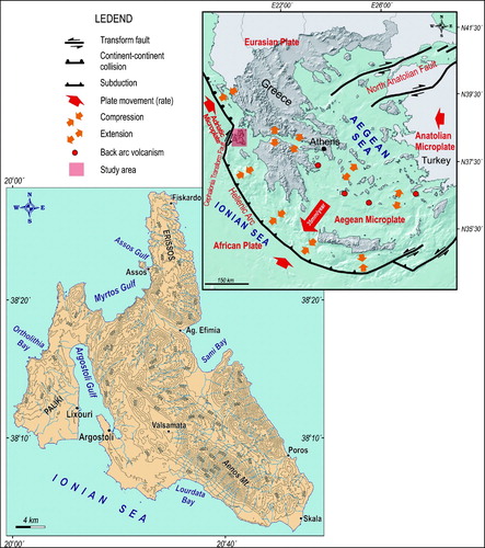
Cephalonia Island occupies an area of 781 km2 and is located in the Ionian Sea (Western Greece) in a particularly tectonically active area (). The evolution of the island is dependent mainly on the behavior of the Hellenic arc, which lies offshore just west of Cephalonia. Geodynamic processes in the region are related to the active subduction of the African lithosphere beneath the Eurasian plate, which progressively becomes continental convergence in north-western Greece (). The transition occurs along the Cephalonia fault zone, a prominent dextral strike slip fault, located offshore, west of the island (CitationLouvari, Kiratzi, & Papazachos, 1999; CitationScordilis et al., 1985).
Figure 1. Topographic map of Cephalonia Island and location map depicting the geodynamic setting of the broader Aegean area (geodynamic setting map is based on CitationGaki-Papanastasiou, Maroukian, Karymbalis, & Papanastassiou, 2011).
The dominant long-term vertical movement of the island during the Quaternary is uplift. Gradual uplift from the beginning of the Pleistocene has left its imprint on the landscape of Cephalonia. The existence of a series of uplifted marine terraces which have been carved mainly on Pliocene formations along the coasts of the southern part of Cephalonia in addition to the presence of fragmented erosional – disolutional planation surfaces at various elevations on the carbonate rocks of the Alpine bedrock, indicate the importance of neotectonics in the geomorphic evolution of the island.
2. Methods and data used
The data presented in this work were acquired through an integrated geological and geomorphological study. For the geological mapping, field observations were combined with previous published geological maps of the island (CitationBritish Petroleum Co. Ltd., 1971; CitationIGME, 1985) while geomorphic features were identified and mapped through aerial photo and Google Earth image visual inspection and interpretation, digital elevation model (DEM) analysis and extensive fieldwork.
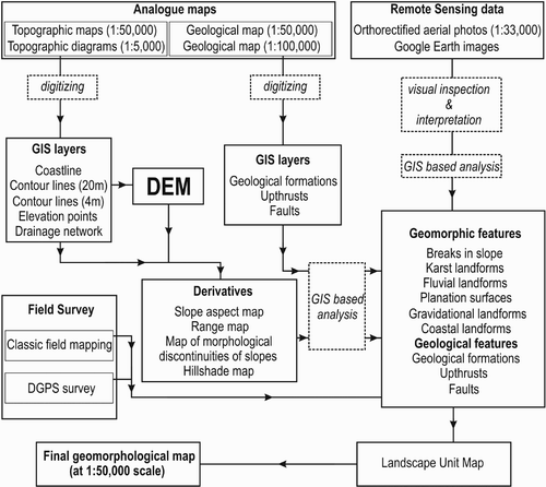
In order to produce the final maps a geographic information system (GIS) spatial data base was designed, organized and implemented using ESRI's ArcGIS9.3 software aiming at the creation of a number of thematic and synthetic layers and maps in a common projection system (Hellenic Geodetic Reference System 1987 – HGRS'87) ().
Figure 2. Flow diagram showing the main steps of the mapmaking method.
Input data were four sheets of 1:50,000 scale analogue topographic maps dating to 1976 of the Hellenic Military Geographical Service covering the island, 30 topographic diagrams of 1:5000 scale covering the Paliki peninsula, the area between Ag. Kyriaki Bay and the Argostoli Gulf, and the southern part of the main island, two sheets of 1:50,000 geological maps published in 1985 by the Institute of Geology and Mineral Exploration of Greece, a geological map published in 1971 by BP Co Ltd at 1:100,000 scale and orthorectified aerial photos from 1996 at 1:33,000 scale obtained from the Greek Ministry of Agriculture. Analogue maps were scanned and georeferenced in the Hellenic Geodetic Reference System 1987. These data were the source for the creation of the primary thematic layers (with point-to-point on screen digitizing) which include coastline, contour lines (with 20-m contour interval – 4 m for some areas), isobaths, elevation points, stream networks, geological formations, faults, upthrusts and fold axes. The geological formations layer was used as intersection with flat surfaces.
GIS procedures produced secondary layers which included a raster DEM of the island, a hillshade map, a slope-aspect map, a range map and a map of morphological discontinuities of slopes.
The basic input data for the production of the DEM were contours with a good density (20-m contour interval, as well as 10 m in some relatively flat regions) together with elevation points and the drainage network from the 1:50,000 scale paper maps. The TOPOGRID algorithm in ArcGIS 9.3 was used to generate a 20-m resolution DEM of Cephalonia Island.
Slope-aspect maps represent the slopes of the terrain classified in regions, as well as the aspect of the slope. The slopes on the island were classified in the following categories: 0–5%, 6–15%, 16–30%, 31–45%, 46–60%, slopes >60%. The angles of aspect were categorized by 45° and were transformed in to Arc/Info format.
The island was divided in categories of 20-m elevation zones. These zones were contained in a range polygon layer. The layer of morphological discontinuities of slopes was a compilation of the thematic layers of aspect, slope and range. The morphological discontinuities are boundaries of polygons with specific characteristics in the layer of the slopes and represent the differences in slope of more than 20%. This layer was useful for mapping abrupt breaks of slope.
Aerial photos and Google Earth images were used for visual inspection and interpretation along with DEM analysis as a first step to generate the tentative preliminary map as a base for fieldwork. Some of the landforms (planation surfaces, poljes, dolines, intense downcutting, marine cliffs, marine terraces, landslide scarps and bodies) were initially digitized directly in Google Earth where they were saved as KML-files. These were then converted to shapefiles using the Department of Natural Resources Garmin application (http://www.dnr.state.mn.us/mis/gis/tools/arcview/extensions/DNRGarmin/DNRGarmin.html) and organized in thematic layers according to the type of each landform.
Field mapping survey (using Differential Global Positioning System or DGPS) was carried out to check and evaluate the accuracy of the landforms initially derived from inspection and interpretation of aerial photos and Google Earth images and DEM analysis. The field survey combined classic field mapping with DGPS survey. Classic field mapping at the detailed scale (topographic maps at 1:5000 scale with 4-m contour lines) was performed for the Paliki Peninsula and the south part of the main island for identification and mapping of marine terraces, uplifted beachrocks and marine notches while for the rest of the study area field recognition of landforms was achieved using the topographic maps at the scale of 1:50,000. A Topcon GMS-2 DGPS was used in the field to check landforms' boundaries accuracies (mainly polygon-type features like geological formations, landslide bodies, marine terraces, planation surfaces, alluvial fans, karst landforms). The accuracy of the DGPS used is considered to be suitable for both 1:50,000 and 1:5000 scale field survey. DGPS was also used also to mark linear features such as coastal landforms (beaches, cliffs, notches) slope changes, and ridges as well as to determine and mark the precise location of point landforms (mainly knickpoints, caves, uplifted beachrocks, etc).
Results from the above methods were summarized in a 1:50,000 scale geomorphological map. A 20-m resolution gray-scale hillshade map of the island derived from the DEM was used as the background of the final map.
2.1. Climate and hydrology
Western Greece is located on the preferential paths of the Mediterranean cyclonic systems accompanied by frontal zones which are responsible for the development of torrential rains especially during autumn and winter.
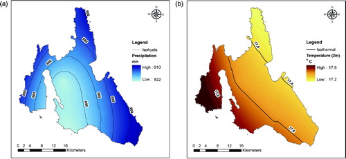
The isohyet and isothermal maps () for the island show the distribution of mean annual precipitation and average air temperature, respectively (CitationKatsafados, Kalogirou, Papadopoulos, & Korres, 2012). Mean annual precipitation varies from 820 mm at the southern part of the island to more than 900 mm at its eastern part. The mean annual temperature range is almost 0.7°C with a northeastern to southwestern slight increase gradient.
Figure 3. (a) Isohyet and (b) isothermal maps of Cephalonia Island based on the European Centre for Medium-Range Weather Forecasts (ECMWF) gridded analyses. Mean annual temperatures refer to the period from 1990 to 2007 while mean values for precipitation refer to the period from 1980 to 2001 (CitationKatsafados et al., 2012).
In addition to the European Centre for Medium-Range Weather Forecasts gridded long-term means, the climatology of the accumulated precipitation and the near surface temperature was extracted from the conventional meteorological station which is located in the capital of the island, Argostoli and belongs to the surface observation network of the Hellenic National Meteorological Service. According to the 27-year records, the mean annual precipitation is 718 mm, unevenly distributed throughout the year, with most (636 mm) falling during winter and the transient periods (). The wettest months of the year are October, November, December and January with mean precipitation of 99.9 mm. The mean annual air temperature at Argostoli is 18.1°C, while the warmest month of the year, August, reveals an average temperature of 25.9°C. Moreover the coldest months of the year are January and February with an average temperature of 11.5°C.
Figure 4. Diagrams of monthly averages for (a) precipitation and (b) mean air temperature over a year for the period 1970–1997 at Argostoli meteorological station.

Under the Köppen classification, Cephalonia climate belongs to the dry-summer subtropical category usually referred to as typical Mediterranean and encoded as Csa. The relatively high precipitation and the high mean annual temperature in addition to the dominance of carbonate rocks (limestones and dolomites) are favorable conditions for the extensive development of karst landforms.
All surface and ground water in the study area is the result of precipitation. Changes in climatic conditions such as precipitation and temperature can cause large and rapid changes in streamflow and more gradual changes in ground water flow. The streams of the island are of seasonal flow and there are no discharge gauges.
The island has not received much attention on water quality. However a three-year monitoring study assessed the chemical and microbiological quality of the harvested rainwater of the northern part of the island (CitationSazakli, Alexopoulos, & Leotsinidis, 2007). Chemical analysis of rainwater and mixed or ground water showed that the PH values range from 7.63 to 8.80 with a mean value of 8.35, indicating that in the studied area the rain is not acid. Rainwater has low-medium values for conductivity (median conductivity 103 µS cm−1) and low-medium level of ions of marine origin (median Na+: 6 ppm, Cl−: 7 ppm). Rainwater contains the elements Ca and Mg in relatively adequate concentrations. The highest value of hardness measured in rainwater was 74 mg l−1 CaCO3 and the median value was 40 mg l−1 CaCO3. Fluoride is not detected in rainwater while Metals, either essential or toxic, are present in traces (CitationSazakli, Alexopoulos, & Leotsinidis, 2007). In general, conductivity and most of the ions show lower values in rainwater than in mixed or ground water. Manganese and Cadmium are present in lower levels in rainwater than in other water, while mean PH was higher in rainwater (CitationSazakli, Alexopoulos, & Leotsinidis, 2007). There is a seasonal variation for some main ions and consequently for conductivity, with higher values being detected in winter.
3. Geological setting
The bedrock of the island consists of two main bedrock units: (1) the east dipping, NW to NNW striking, thrust sheet fragments of a carbonate platform belonging mainly to the Pre-Apulian (or Paxos) geotectonic unit (CitationUnderhill, 1985), and (2) the Ionian unit occupying a relatively small part of the eastern island (BP Co Ltd, 1971; IGME, 1985).
The individual smaller inset map shows that the Pre-Apulian (Paxos) geotectonic unit consists of Cretaceous limestones and dolomites overlain by Paleocene–Eocene–Oligocene (?) thick-bedded limestones. On top of them lie conglomeratic and brecciated limestones of Upper Oligocene to Upper Miocene age.
The Ionian geotectonic unit formations outcropping in the island are Pantocrator limestones of Upper Trias–Middle Lias age overlain by the Upper Lias-Middle Dogger age Ammonitico Rosso formation, which consists of thin bedded platy limestones with marly intercalations. Middle-Upper Dogger is represented by alternations of shales and limestones overlain by Vigla limestones with chert layers of Upper Jurassic–Lower Cretaceous age. On top of them Upper Jurassic–Lower Cretaceous breccias and limestones occur while Paleocene and Eocene is represented by limestones.
This basement is overlain by extensive outcrops of Neogene and Quaternary deposits in the southern and eastern part of the Paliki peninsula and the south part of the main island. In the Lower Pliocene there is a short stratigraphic hiatus and a transgressive well-bedded conglomeratic facies. These conglomerates are overlain by a limestone bed passing upwards into sand, sandstone and sandy limestone with layers of blue marls. Upwards, the blue marls predominate and enclose a rich mollusc fauna while in the uppermost part a series of fine-grained sandstones and sandy marls reappear. Pleistocene formations are composed mainly of conglomerates and sandstones and occur at the north part of Paliki peninsula and along the southern foot of Aenos Mt. At locations along the eastern coast of the Paliki peninsula, sandstone formations were observed capping hills whose elevations reach 160 m a.s.l. while beachrock formations at elevations between 21.6 and 6.5 m of Tyrrhenian age exist in the southern coasts of the main island and the Paliki peninsula (CitationBraune, 1973; CitationSorel, 1976). The Holocene deposits consist of alluvial fans, scree, and high-energy fluvial deposits mainly deposited along the stream channels as well as solution depression fillings consisting of terra rossa and fluvial sand and gravels.
The dominance of carbonate rocks in combination, with favorable climate conditions for dissolution, have enhanced the formation of karst landforms especially in the north and central part of the island. The southern part of Cephalonia where Pliocene and Pleistocene formations occur is dominated by the presence of uplifted marine terraces, which correspond to past sea-level highstands. These uplifted marine terraces at gradually higher elevations are morphological markers of sea-level fluctuations and continuous tectonic uplift during the Quaternary. Furthermore, gradual tectonic uplift of the island led to the formation of erosional planation surfaces on the Alpine carbonate bedrock.
The general trend of the faults is mainly NW–SE with some secondary ones having NE–SW direction. The area is characterized by intense seismicity with strong frequent earthquakes. Since the fifteenth century, 21 earthquakes with magnitudes greater than 6.5 have severely affected the island while nine of them have occurred during the last century (Papazachos & Papazachou, 1997). During the last millennia two vertical displacements have been verified, which affected most of the island, associated with co-seismic uplift. The first occurred between 350 and 710 AD and the second during the 1953 earthquake, which mainly uplifted the southeastern part of the island by 50 and 70 cm, respectively. (CitationPirazzoli et al., 1994, CitationStiros, Pirazzoli, Laborel, & Laborel-Deguen, 1994). Recent studies performed by different teams, based on GPS,DGPS measurements and Permanent Scatterer Interferometric analysis covering the period 1992 to 2010, have revealed horizontal clockwise rotation of Cephalonia with velocities ranging from 3 to 8 mm/yr, the largest values occurring at the western and southern parts of the island (CitationCocard et al., 1999; CitationHollenstein, Geiger, Kahle, & Veis, 2006; CitationLagios et al., 2007, Citation2012). For the vertical deformation CitationLagios et al. (2012) distinguished two periods: the period 1992 to 2003 shows linear slight subsidence (around 1 mm/yr). The second period, 2003 to 2010, shows uplift (2–4 mm/yr) that occurred mainly along the southern and south-eastern parts of the island, while larger magnitudes (>4 mm/yr) took place at the western part. These results present the complex tectonics of the island, indicating that it is composed of different tectonic blocks that do not behave uniformly over time.
4. Geomorphic features
4.1 Drainage networks
The main mountain mass of Cephalonia Island is Aenos (1630 m a.s.l.) occupying the central part of the island, oriented in a NW–SE direction. The principal water divide has the same direction with a well developed drainage pattern on the eastern part of the main island where the two largest fifth-order (according to CitationStrahler's (1957) classification system) networks exist. The main channel flow directions of these networks are to the NE (Sami Bay) and the SW (Poros), with the development of the main streams channels controlled by lithological contacts, faults and upthrusts. The coastal zone of the southern part of the main island consists of relatively steep slopes with relatively short streams of first and second order. The area bounding the eastern side of Argostoli Gulf, is characterized by very steep limestone cliffs (with slopes between 39 and 78%) due to the neotectonic origin of the Gulf (CitationGaki-Papanastasiou, Maroukian, Karymbalis, & Papanastassiou, 2011), with a small parallel not well-developed drainage network.
The Erissos Peninsula, the central part of which is an extensive, partially karstified, planation surface, is drained by short streams discharging directly into the sea (Main map). The eastern ones are more heavily incised probably due to higher tectonic uplift rates since the east almost straight cliffed shoreline of the peninsula is affected by a NNW–SSE trending coastal fault.
The northeastern part of the Paliki peninsula is drained by three major drainage networks with the upper reaches flowing in a NNW–SSE direction and then turning to the east discharging into Argostoli Gulf. The uppermost parts of these drainage networks are the oldest as they have evolved on limestones of Eocene–Oligocene and Miocene age while their lowermost parts passing through the Pliocene formations are much younger (CitationGaki-Papanastassiou, Karymbalis, Maroukian, & Tsanakas, 2010). These drainage networks were tributaries of a much larger drainage pattern which was active during the last glacial period up until early Holocene. The main channel of this drainage network had an almost N–S direction flowing along the eastern side of the present Argostoli Gulf which was a valley during the early Holocene (CitationGaki-Papanastasiou, Maroukian, Karymbalis, & Papanastassiou, 2011). The submarine continuation of drainage networks in the area around the Argostoli Gulf is depicted on the Main map. The bathymetry of the gulf reveals that it is a shallow submarine valley with a maximum depth of about 25 m east of cape Ag. Georgios. Its western submarine slopes are less steep than the eastern ones probably due to structural reasons since the strata on the western Paliki peninsula are dipping toward the gulf as well as due to the deposition of sediments supplied by the drainage networks of the Paliki peninsula. At the southern part of the Paliki peninsula there are two drainage networks. Their upper parts have developed on limestone formations having a low drainage density while their more extensive lower parts drain Pliocene formations.
4.2 Karst landforms
The Main map shows that the island is intensely karstified with the presence of dolines, poljes, sinkholes and caves. Karst landforms occur in association with the highly soluble carbonate rocks of Cretaceous age. The most remarkable surface karst landforms are the Valsamata and Trogianata poljes (. Smaller karst depressions are located at the western part of the island just north of the Argostoli Gulf.
Figure 5. (a) The polje of Valsamata; (b) Karst depression on the extensive planation surface of Erissos Peninsula.
Noteworthy in the central part of the Erissos Peninsula is the existence of a fragmented extensive karst planation surface ranging in elevation from 200 m in the north to more than 800 m in the south (. Karst fill sediments tend to be a mixture of terra rossa and high-energy fluvial deposits. Caves are widely distributed over the island particularly in the broader area of Sami and southeast of Argostoli.
Cephalonia Island is the site of one of the most astonishing hydrological phenomena in the world. Seawater current flows continuously into the karstic substratum of the island through sinkholes which have formed in fractures in the carbonate rocks on the southwest coast near the town of Argostoli (CitationDrogue, 1989). Current flow can reach as much as 0.3 m3 s−1 and is sufficiently powerful to drive millwheels. CitationMaurin & Zotl (1967) used a tracer to show that the seawater reappears on the eastern coast of the island as brakish springs (near the town of Sami). The underground route is 15-km long.
4.3. Planation surfaces
In the study area several planation surfaces located at different elevations ranging from 100 m to more than 1300 m around Aenos Mt. were mapped. All the fairly flat surfaces developed on the Alpine bedrock (limestones of Jurassic and Cretaceous age) have been mapped as planation surfaces. These surfaces were formed by the combined action of erosion and disolution and their development probably reflects the gradual tectonic uplift of the island. During geomorphological mapping, denudation surfaces were grouped according to their elevation into nine classes. Dissolution seems to be most important for the development of the extensive karstified planation surfaces of the Erissos peninsula. It is possible that planation surfaces represent remnants of older, fewer and more extensive erosional surfaces that were subsequently tectonically segmented into smaller pieces located at different elevations today (CitationGaki-Papanastasiou, Maroukian, Karymbalis, & Papanastassiou, 2011). On the north and east slopes of Aenos Mt. fragmented pediment surfaces were identified and mapped ranging in elevation from 340 to 720 m a.s.l. (). These surfaces show features typical for a pediment that are up to 1.5-km wide and inclined toward the neighboring valleys at 15%. Locally the surfaces are separated from the stream valleys by distinct erosional escarpments.
Figure 6. Pediment surface developed on carbonate rocks at an elevation of 500 m, on the northeast slopes of Aenos Mt., west of Poros.
4.4. Gravitational landforms
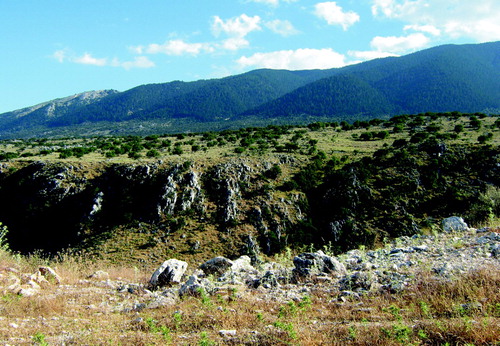
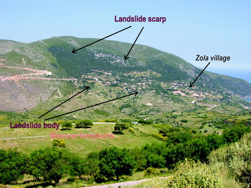
In the course of the fieldwork, a landslide was recognized and mapped at Zola village probably triggered by the re-activation of a normal NE–SW trending fault located west of the settlement by a strong earthquake. The nearby identical slope of the mountain sides and the dip of the strata played a major role in causing this landslide (). This mass wasting event occurred some hundreds of years or a few thousand years ago (CitationGaki-Papanastasiou, Maroukian, Karymbalis, & Papanastassiou, 2011). Along the slopes of the eastern coast of Agia Kyriaki Bay, mudflows and debris flows are observed. Locally the activation of these movements is enhanced by the susceptibility to failure of the Miocene formations. Along the steep coasts of the island and particularly on the eastern and western sides, rock falls are very common.
Figure 7. Landslide along the steep slopes of Agrilia Mt.
4.5. Coastal geomorphology
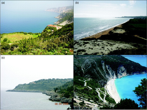
About two thirds of the total coastline length of the island is characterized by steep slopes (ranging from 21% to 96%) with the occurrence of more than 15 pocket beaches (; h).
The main map shows that the western coast of the Paliki peninsula is steep (with slopes between 54% and 96%) comprising limestone cliffs that reach the maximum height of about 240 m a.s.l. (. This part is subject to coastal erosion. On the other hand, the eastern coast of Paliki is characterized by much lower slopes and sandy beaches. Three small coastal fans have formed at the mouths of the major drainage systems along the western shores of the Argostoli Gulf. The main reasons for these differences in the coastal geomorphology are the lithology (the western coasts consist of hard to erode limestone formations while the eastern part is composed of highly erodible Pliocene formations) as well as the tectonic regime of the peninsula which was characterized by gradual uplift raising the older limestone formations and creating a NNE–SSW slope of the carbonate platform (CitationGaki-Papanastassiou, Karymbalis, Maroukian, & Tsanakas, 2010)
In most of the southern coast steep cliffs occur (with slopes ranging from 32% to 64%) except in some parts where Pliocene conglomerates, sandstones and marls exist. There, sandy beaches are located around the Capes Ag. Nikolaos, Ag. Pelagia, Liakas and Lourdata Bay. High cliffs are observed where Aenos Mt approaches the coast, between Capes Katsonas and Koroni.
In the Paliki Peninsula, as well as along the southern coast of the main island, several uplifted geomorphological features were mapped, including marine terraces, marine notches, beachrocks and aeolianites. Remnants of Quaternary marine terraces have been identified at several locations on the island. The uplifted Quaternary marine terraces are excellent morphological markers and have been used worldwide to recognize past sea-level changes. Their correlation with the main interglacial highstands can be done only in areas where a continuous uplift at a regional scale exists combined by dating their exposure. Along the coasts of southern Cephalonia Island the existing uplifted marine terraces are imprinted into pre-existing Mio-Pliocene marine formations and only a few of them have a thin sandstone caprock. However it was difficult to find datable material and we were unable to correlate the terraces in space and time. Nevertheless, the occurrence of the terraces of Paliki peninsula and of the southern part of the main island, at different elevations, supports the suggestion that the island is composed by different tectonic blocks moving disparately.
The detailed field geomorphological mapping revealed a sequence of eight marine terraces in the Paliki peninsula ( and ). The lower two terraces are the most continuous and well preserved and are located at elevations between 2–16 and 18–32 m a.s.l. respectively. Remnants of higher marine terraces were distinguished at elevations between 34–60, 60–74, 76–112, 136–160, 180–300 and 300–440 m a.s.l., respectively. The inner edges of these higher platforms were difficult to distinguish mainly due to the erodible lithology of the Pliocene formations. The three higher marine terraces, which have developed on Eocene–Oligocene limestone, seem to represent former shorelines which should have been carved during the Pliocene.
Figure 8. (a) Marine terraces at 90 m a.s.l. Steep faulted limestone cliffs are also seen in the background. Cape Schiza, western coast of Paliki; (b) The lowest marine terrace (2–16 m a.s.l.) photographed from the second terrace west of Cape Ag. Georgios, southern shore of Paliki; (c) Uplifted marine terraces and notch at Cape Kapri, SE area of the island; (d) The pocket beach of Myrtos.
In the southern part of the main island there exist eight uplifted marine terraces extending along a narrow coastal zone in the southeast and southwest corners (. They are mainly formed on Pliocene formations and range at elevations 2–4, 4–20, 20–40, 40–60, 60–90, 92–140 and 142–170 m a.s.l.
On the main island three Late Holocene uplifted marine notches were identified reaching up to 3 m a.s.l. At the southern and southeastern coast of Paliki peninsula uplifted beachrocks at 5 m a.s.l. were observed together with aeolianites reaching a height of 5 to 6 m a.s.l. and a marine notch at 1–2 m a.s.l. (.
Based on the raised coastal features of the study area it becomes evident that the prevailing tectonic movement is positive (emergence) during the Pleistocene and Holocene periods. The slightly higher elevations of the marine terraces in the southern part of the main island, in comparison with those of Paliki peninsula, are evidence of relatively higher rates of uplift during the Quaternary.
5. Conclusion
The geomorphological map of Cephalonia at the scale of 1:50,000 presented in this work portray the distribution of landforms and earth surface processes over the island and lead to conclusions about the recent evolution of the landscape. Geomorphological mapping has shown that geomorphic features reflect the importance of neotectonic processes in the recent evolution of Cephalonia. A large part of the southern island was underwater during the Pliocene. From the beginning of the Pleistocene gradual uplift of the area began, raising the older limestone formations. In the Paliki peninsula carbonate marine terraces were formed dipping NNE–SSW, with the younger marine terraces carved on the Pliocene formations. The terraces extend in a north–south direction, while on the main island they are from west to east. Given the different elevations of the marine terraces as well as the other uplifted coastal geomorphological features of the island, the two parts (Paliki Peninsula and the southern main island) had different uplift regimes being located on different tectonic blocks. Marine terraces at the southern part of the main island were mapped up to about 20 m higher than those of the same group which are located at Paliki peninsula. This is evidence of slightly higher uplift rates during the Quaternary for the southern part of the main Cephalonia Island. Elevation differences between the erosional planation surfaces reveal the importance of neo-tectonism on the behavior of these blocks. The highest elevation where Pliocene formations exist in the Paliki peninsula is 160 m a.s.l. while in the southern part of the main island they reach 170 m a.s.l. The minimum long-term tectonic uplift rate for the southern part of Cephalonia during the Quaternary, is estimated to be about 0.2 mm/yr.
The existence of uplifted marine notches as well as uplifted beachrocks and aeolianites along the coastline of the southern island indicate the recent Holocene uplift of this part of the island.
Software
ESRI ArcGIS 9.3 was used to digitize the data collected during field survey and aerial photo interpretation. The DEM was derived from topographic maps at a scale of 1:50,000 obtained from the Hellenic Military Geographical Service. The final layout of the geomorphological and geologic map was assembled using Corel Draw12.
Supplemental Material
Download PDF (8.5 MB)Acknowledgements
We would like to thank Dr Paolo Paron and Dr Mike Smith, Editors of the Special Issue and two anonymous reviewers for their helpful suggestions, comments and corrections that significantly improved the paper.
Related Research Data
References
- Braune, K. , 1973. Die rezenten und pleistozaenen Sedimente des Sublitorals von Kephallinia (Ionische Inseln) , Senckenbergiana Maritima 5 (1973), pp. 99–133.
- British Petroleum Co. Ltd, 1971. The geological results of petroleum exploration in western Greece, Athens, Greece . Institute for Geological and Subsurface Research (Report No 10); 1971.
- Cocard, M. , Kahle, H. G. , Geiger, A. , Veis, G. , Felekis, S. , Paradissis, D. , and Biliris, H. , 1999. New constrains on the rapid crustal motion of the Aegean region: Recent results inferred from GPS measurements (1993–1998) across the West Hellenic Arc, Greece , Earth and Planetary Science Letters 172 (1999), pp. 39–47, doi: 10.1016/S0012-821X(99)00185-5.
- Drogue, C. , 1989. Continuous inflow of saltwater and outflow of brackish water in the substratum of the karstic island of Cephalonia, Greece , Journal of Hydrology 106 (1989), pp. 147–153.
- Gaki-Papanastassiou, K. , Karymbalis, E. , Maroukian, H. , and Tsanakas, K. , 2010. Geomorphic evolution of Western (Paliki) Kephalonia Island (Greece) during the Quaternary , Bulletin of the Geological Society of Greece XLIII (1) (2010), pp. 418–427.
- Gaki-Papanastasiou, K. , Maroukian, H. , Karymbalis, E. , and Papanastassiou, D. , 2011. "Geomorphological study and palaeogeographic evolution of NW Kefalonia Island, Greece, concerning the hypothesis of a possible location of the Homeric Ithaca". In: Brown, A. G. , Dasell, L. S. , and Butzer, K. W. , eds. Geoarchaeology, Climate Change, and Sustainability, Geological Society of America Special Paper 476 . 2011. pp. 69–79, doi: 10.1130/2011.2476(06).
- Hollenstein, Ch. , Geiger, A. , Kahle, H. G. , and Veis, G. , 2006. CGPS time-series and trajectories of crustal motion along the West Hellenic Arc , Geophysical Journal International 164 (2006), pp. 182–191, doi: 10.1111/j.1365-246X.2005.02804.x.
- Institute of Geology and Mineral Exploration (IGME). (1985). Geological map of Kefalonia Island. Scale 1:50000..
- Katsafados, P. , Kalogirou, S. , Papadopoulos, A. , and Korres, G. , 2012. Mapping long-term atmospheric variables over Greece , Journal of Maps (2012), 8/2, 181–184, doi: 10.1080/17445647.2012.694273.
- Lagios, E. , Papadimitriou, P. , Novali, F. , Sakkas, V. , Fumagalli, A. , Vlachou, K. , and Del Conte, S. , 2012. Combined seismicity pattern analysis, DGPS and PSInSAR studies in the broader area of Cephalonia (Greece) , Tectonophysics, 524-525 (2012), pp. 43–58, doi: 10.1016/j.tecto.2011.12.015.
- Lagios, E. , Sakkas, V. , Papadimitriou, P. , Parcharidis, I. , Damiata, B. N. , Chousianitis, K. , and Vassilopoulou, S. , 2007. Crustal deformation in the central Ionian Islands (Greece): Results from DGPS and DInSAR analyses (1995–2006) , Tectonophysics 444 (2007), pp. 119–145, doi: 10.1016/j.tecto.2007.08.018.
- Louvari, E. , Kiratzi, A. A. , and Papazachos, B. C. , 1999. The Cephalonia transform fault and its extension to western Lefkada Island (Greece) , Tectonophysics 308 (1999), pp. 223–236, doi: 10.1016/S0040-1951(99)00078-5.
- Maurin, V. , and Zotl, J. , 1967. Salt water encroachment in the low altitude karst water horizons of the island of Kephallinia (Ionian Islands) , Proc Dubrovnik Symp. Int. Assoc. Sci. Hydrol. 74 (1) (1967), pp. 423–438.
- Papazachos, B. , and Papazachou, C. , 1997. The earthquakes of Greece . Thessaloniki: Ziti Publications; 1997. p. 305.
- Pirazzoli, P. A. , Stiros, S. C. , Laborel, J. , Laborel-Deguen, F. , Arnold, M. , Papageorgiou, S. , and Morhange, C. , 1994. Late Holocene shoreline changes related to palaeoseismic events in the Ionian Islands, Greece , The Holocene 4 (4) (1994), pp. 397–405, doi: 10.1177/095968369400400407.
- Sazakli, E. , Alexopoulos, A. , and Leotsinidis, M. , 2007. Rainwater harvesting, quality assessment and utilization in Kefalonia Island, Greece , Water Research 41 (2007), pp. 2039–2047, doi: 10.1016/j.watres.2007.01.037.
- Scordilis, E. , Karakaisis, G. , Karakostas, B. , Panagiotopoulos, D. , Comninakis, P. , and Papazachos, B. , 1985. Evidence for transform faulting in the Ionian Sea: The Cephalonia Island earthquake sequence of 1983 , Pure and Applied Geophysics 123 (1985), pp. 388–397, doi: 10.1007/BF00880738.
- Sorel, D. , 1976. 1976, Etude néotectonique des îles Ioniennes de Céphalonie et de Zante et de l' Elide occidentale (Grèce)., These 3e cycle. Orsay: University Paris Sud.
- Stiros, S. C. , Pirazzoli, P. A. , Laborel, J. , and Laborel-Deguen, F. , 1994. The 1953 earthquake in Cephalonia (Western Hellenic Arc): Coastal uplift and halotectonic faulting , Geophysical Journal International 117 (1994), pp. 834–849, doi: 10.1111/j.1365-246X.1994.tb02474.x.
- Strahler, A. N. , 1957. Quantitative analysis of watershed geomorphology , Transactions of the American Geophysical Union 8 (6) (1957), pp. 913–920.
- Underhill, J. , 1985. Neogene and Quaternary tectonics and sedimentation in Western Greece . 1985, (Thesis PhD). University of Wales.