Abstract
In this paper we present the land units map of Italy, covering an area of ca. 300,000 km2 between 47°05′ N–35°29′ N and 6°37′ E–18°31′ E. The map was created by means of a Geographic Information System (GIS) and is based on the overlay of various thematic maps according to a hierarchical classification. The map scale is 1:250,000, with a minimum mapping unit of 50 ha. The GIS integration of different layers, covering the main environmental components (climate, lithology and geomorphology), resulted in a number of hierarchically arranged land units, homogeneous in terms of biotic potential and ecological processes. These units highlight the role of physical determinism in characterizing the Italian territory with a high degree of environmental heterogeneity. The proposed land classification scheme could be taken into consideration when planning initiatives aimed at surveying, monitoring, managing and sustainably developing the territory.
1. Introduction
In landscape ecological classification, land units are zones, defined on any scale, that display a certain degree of environmental homogeneity (CitationOmernik & Bailey, 1997) and are considered as units of analysis (CitationLoveland & Merchant, 2004; CitationWessels, Freitag, & van Jaarsveld, 1999). A spatial division of a geographic area into land units can be used to identify patterns of components that are dependent upon one another (CitationKlijn & Udo de Haes, 1994; CitationZonneveld, 1995), thereby providing a rational basis for addressing a number of multi-scale problems in the field of landscape management and research (CitationCleland et al., 1997; CitationSanchez & Priego-Santander, 2011). These units represent a geographical framework that can be used to manage the territory according to ecological boundaries as opposed to political or administrative boundaries (CitationGallant, Loveland, Sohl, & Napton, 2004; CitationOmernik, 2004; CitationU.S. GAO, 1994). The environmental structure of land is controlled by the more stable physical features (e.g. climatic conditions, geological substrate and landform), which determine the distribution of species, habitats and potential natural vegetation types, and affect the use of the territory (CitationBlasi & Frondoni, 2011; CitationMcMahon, Wiken, & Gauthier, 2004; CitationOliver et al., 2004). Therefore, land units can be identified at different geographic scales by integrating the basic environmental features of the landscape (CitationBailey, 2004; CitationCleland et al., 1997; CitationZonneveld, 1995). Factors that control patterns can be used to classify types and map their boundaries (CitationBailey, 1996).
This paper illustrates a method for the definition and mapping of land units in Italy resulting from a project funded by the Italian Ministry of the Environment, Land and Sea Protection. The project focused on a uniform national ecological classification to provide a common basis for environmental analysis at various levels. In particular, land units helped to characterize in Italy the potential natural vegetation types, defined as the vegetation in a given habitat that would develop at once to a mature stage without human influences (CitationTüxen, 1956), and related secondary successional stages (CitationBlasi et al., 2011; CitationRosati, Marignani, & Blasi, 2008). This paper also contributes to the implementation of the European Landscape Convention (Council of Europe, Florence, 20.X.2000) by providing data on the diversity of landscape typologies at the national level.
2. Study area
Italy is located in the central Mediterranean basin between 47°05′ N – 35°29′ N and 6°37′ E – 18°31′ E. It covers approximately 300,000 km2 and has a highly heterogeneous distribution of climate, physiography, vegetation cover and land use. There are two main mountain ranges (the Alps and the Apennines), extensive hilly zones, wide river valleys (first and foremost the Po plain), many large and small islands, and a long coastline.
3. Material and methods
The classification and mapping of land units was based on the relevance of significant environmental factors at different scales. The classification method and the selection of environmental factors follow a hierarchical and divisive approach (CitationBailey, 2004; CitationKlijn, De Waal, & Voshaar, 1995; CitationSayre, Comer, Warner, & Cress, 2009) that identifies typological units occurring repeatedly within a geographic area. The nomenclature follows a scheme developed by CitationBlasi, Carranza, Frondoni, and Rosati (2000; CitationBlasi, Capotorti, & Frondoni, 2005). At coarse levels, the scheme subdivides land into: (i) Land Regions (ranging in scale from 1:1,000,000 to 1:250,000), based on macro-bioclimatic features; (ii) Land Systems (1:250,000 scale), delimited within the Land Regions according to diagnostic lithological features; (iii) Land Facets (ranging in scale from 1:250,000 to 1:50,000), delimited within the Land Systems according to diagnostic geomorphological features.
We systematically collected, homogenized and compiled original thematic maps of the main physical factors at the national level. For climatic regionalization we referred to the Phytoclimatic Map of Italy (scale 1:250,000) (CitationBlasi & Michetti, 2007), extrapolating three climatic regions (Mediterranean, Transitional and Temperate). The lithological thematic layer was created by collecting, homogenizing and synthesizing geological maps at both the national (CitationBigi, Cosentino, Parotto, Sartori, & Scandone, 1992) and regional scales using the 1:100,000 and 1:50,000 geological sheets of the National Geological Service. The final lithological map includes eight lithological classes, plus lakes, glaciers and lagoons, which are kept as distinct units ().
Table 1. Lithological classes used to define the national lithological map.
A geomorphological map was drafted using a digital elevation model from the National Geoportal (http://www.pcn.minambiente.it/) with a grid cell of 75 meters, using the Topographic Position Index (CitationTagil & Jenness, 2008). The final map includes seven morphological classes ().
Table 2. Geomorphological classes used to define the national geomorphological map.
The final digital map of land classification, based on the overlay and integration of the thematic maps, was drawn up at the standard scale of 1:250,000, with a minimum mapping unit of 50 ha. Esri ArcGIS 9.2 was used for the classification process and map production. The map projection is UTM Zone 32N, Datum WGS84.
Further map data, such as hydrography, mountains and main cities, were obtained from the National Geoportal (http://www.pcn.minambiente.it/). Other background images were obtained from the ArcGIS online map service (http://www.arcgis.com/).
4. Results
The land classification process led to the identification and mapping of 3 Land Regions, 24 Land Systems and 149 Land Facets (Main Map).
The Mediterranean Land Region covers 25% of the national territory and is characterized by a summer drought lasting longer than two months, little difference between summer and winter temperature and precipitation concentrated in the autumn/winter period. The Temperate Land Region covers 58% of the national territory and is characterized by brief or no summer aridity, a generally marked difference between winter and summer temperatures and precipitation concentrated in the spring/summer period. The Transitional Land Region covers 18% of the national territory and is characterized by thermic or pluviometric variants of the Mediterranean and Temperate Land Regions.
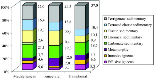
The 24 Land Systems are fairly evenly scattered throughout the three Land Regions (). The larger Land Systems fall within the Temperate Land Region and are associated with sedimentary terrigenous, clastic and carbonate lithological types, whereas the smaller Land Systems are always associated with sedimentary chemical and intrusive igneous lithological types.
Figure 1. Percentage of area covered by the Land Systems in Italy, arranged according to the reference Land Regions.
Only three of the 149 Land Facets cover more than 5% of the national territory. The first is the Temperate Clastic Sedimentary Plain Land Facet, which measures 26,989 km2 (9% of the national territory) and is found mainly in the low Po plain.
The second is the Temperate Terrigenous Sedimentary Slope Land Facet, which measures 19,195 km2 (6% of the national territory) and is distributed mainly in the northern and central Apennines. The third is the Temperate Terraced Clastic Sedimentary Plain Land Facet, which measures 19,089 km2 (6% of the national territory) and is distributed mainly in the high Po plain. For a detailed description of the ecological characteristics of the Land Regions, Land Systems and Land Facets, see Appendix A in CitationCapotorti, Guida, Siervo, Smiraglia, and CitationBlasi (2012a).
5. Conclusions
Land classification offers the opportunity to depict the deterministic effect of physical attributes on ecosystem patterns and associated ecological processes at broad scales. The Land Units Map of Italy resulting from this work led, in particular, to the identification and mapping of the vast environmental heterogeneity that characterizes the Italian peninsula. The hierarchical framework, combined with mapping techniques and GIS, yielded a detailed spatial classification that may be used for various landscape surveying purposes. This multi-scale proposal and the consequent localization and characterization of the land units can be used to define areas that are spatial expressions of specific processes. By shedding light on landscape trends, this specificity helps to address and solve planning and management problems.
Each classification level should be used for purposes that are suited to the scale of the source materials used to compile them. For example, Land Region maps are designed for broad-scale modeling and sampling applications, Land System maps should be used for strategic ecosystem assessment or conservation purposes, while Land Facet maps are more suited to detailed analyses in project-level applications, such as landscape conservation, evaluation or ecological network design (CitationBlasi et al., 2008).
This multilevel scheme thus identifies land units that may be effectively used to address a wide range of landscape goals, such as the assessment of the state of conservation of land mosaics in relation to their potential composition and configuration (CitationCapotorti et al., 2012b), as well as to monitor the main threats to biodiversity, such as climate changes (CitationBeier & Brost, 2010), biological invasions (CitationCelesti-Grapow et al., 2010) and land cover changes (CitationFrondoni, Mollo, & Capotorti, 2011; CitationSmiraglia, Zavattero, Ricotta, & Blasi, 2007).
Software
The final map and related thematic layers were collected, managed and processed using Esri ArcGIS 9.2.
Main Map: Land Units Map of Italy
Download PDF (26.3 MB)Acknowledgments
This work was supported by the Ministry for the Environment, Land and Sea Protection of Italy. We would like to thank Leopoldo Michetti for his helpful advice.
Related Research Data
References
- Bailey , R. G. 1996 . Ecosystem geography , New York : Springer-Verlag . 240 pp
- Bailey , R. G. 2004 . Identifying ecoregion boundaries . Environmental Management , 34 ( suppl. 1 ) : S14 – S26 . (doi:10.1007/s00267-003-0163-6)
- Beier , P. and Brost , B. 2010 . Use of land facets to plan for climate change: Conserving the arenas, not the actors . Conservation Biology , 24 ( 3 ) : 701 – 710 . (doi:10.1111/j.1523-1739.2009.01422.x)
- Bigi , G. , Cosentino , D. , Parotto , M. , Sartori , R. and Scandone , P. 1992 . Modello strutturale tridimensionale d'Italia in scala 1:500.000 , Roma : CNR-Centro Nazionale delle Ricerche .
- Blasi , C. , Capotorti , G. and Frondoni , R. 2005 . Defining and mapping typological models at the landscape scale . Plant Biosystems , 139 ( 2 ) : 155 – 163 . (doi:10.1080/11263500500163629)
- Blasi , C. , Capotorti , G. , Frondoni , R. , Guida , D. , Mollo , B. , Smiraglia , D. and Zavattero , L. 2011 . Vegetation science and the ecoregional approach: A proposal for the ecological land classification of Italy . Fitosociologia , 48 ( 2 suppl. 1 ) : 75 – 82 .
- Blasi , C. , Carranza , M. L. , Frondoni , R. and Rosati , L. 2000 . Ecosystem classification and mapping: A proposal for Italian landscapes . Applied Vegetation Science , 3 ( 2 ) : 233 – 242 . (doi:10.2307/1479002)
- Blasi , C. and Frondoni , R. 2011 . Modern perspectives for plant sociology: The case of ecological land classification and the ecoregions of Italy . Plant Biosystems , 145 ( suppl ) : 30 – 37 . (doi:10.1080/11263504.2011.602747)
- Blasi , C. and Michetti , L. 2007 . “ The climate of Italy ” . In Biodiversity in Italy , Edited by: Blasi , C. , Boitani , L. , La Posta , S. , Manes , F. and Marchetti , M. 57 – 66 . Roma : Palombi Editori .
- Blasi , C. , Zavattero , L. , Marignani , M. , Smiraglia , D. , Copiz , R. , Rosati , L. and del Vico , E. 2008 . The concept of land ecological network and its design using a land unit approach . Plant Biosystems , 142 ( 3 ) : 540 – 549 . (doi:10.1080/11263500802410892)
- Capotorti , G. , Guida , D. , Siervo , V. , Smiraglia , D. and Blasi , C. 2012a . Ecological classification of land and conservation of biodiversity at the national level: The case of Italy . Biological Conservation , 147 ( 1 ) : 174 – 183 . (doi:10.1016/j.biocon.2011.12.028)
- Capotorti , G. , Zavattero , L. , Anzellotti , I. , Burrascano , S. , Frondoni , R. , Marchetti , M. , Marignani , M. , Smiraglia , D. and Blasi , C. 2012b . Do national parks play an active role in conserving the natural capital of Italy? . Plant Biosystems , 146 ( 2 ) : 258 – 265 .
- Celesti-Grapow , L. , Alessandrini , A. , Arrigoni , P. V. , Assini , S. , Banfi , E. , Barni , E. , Bovio , M. , Brundu , G. , Cagiotti , M. R. , Camarda , I. , Carli , E. , Conti , F. , Del Guacchio , E. , Domina , G. , Fascetti , S. , Galasso , G. , Gubellini , L. , Lucchese , F. , Medagli , P. , Passalacqua , N. G. , Peccenini , S. , Poldini , L. , Pretto , F. , Prosser , F. , Vidali , M. , Viegi , L. , Villani , M. C. , Wilhalm , T. and Blasi , C. 2010 . Non-native flora of Italy: Species distribution and threats . Plant Biosystems , 144 ( 1 ) : 12 – 28 . (doi:10.1080/11263500903431870)
- Cleland , D. T. , Avers , P. E. , McNab , W. H. , Jensen , M. E. , Bailey , R. G. , King , T. and Russell , E. 1997 . “ National hierarchical framework of ecological units ” . In Ecosystem management applications for sustainable forest and wildlife resources , Edited by: Boyce , M. S. and Haney , A. 181 – 200 . New Haven : Yale University Press .
- Frondoni , R. , Mollo , B. and Capotorti , G. 2011 . A landscape analysis of land cover change in the Municipality of Rome (Italy): Spatio-temporal characteristics and ecological implications of land cover transitions from 1954 to 2001 . Landscape and Urban Planning , 100 ( 1–2 ) : 117 – 128 . (doi:10.1016/j.landurbplan.2010.12.002)
- Gallant , A. L. , Loveland , T. R. , Sohl , T. L. and Napton , D. E. 2004 . Using an ecoregion framework to analyze land-cover and land-use dynamics . Environmental Management , 34 ( suppl.1 ) : S89 – S110 . (doi:10.1007/s00267-003-0145-3)
- Klijn , F. , De Waal , R. W. and Voshaar , J. H. O. 1995 . Ecoregions and ecodistricts – ecological regionalizations for the Netherlands environmental-policy . Environmental Management , 19 ( 6 ) : 797 – 813 . (doi:10.1007/BF02471933)
- Klijn , F. and Udo de Haes , H. A. 1994 . A hierarchical approach to ecosystems and its implications for ecological land classification . Landscape Ecology , 9 ( 2 ) : 89 – 104 .
- Loveland , T. R. and Merchant , J. M. 2004 . Ecoregions and ecoregionalization: Geographical and ecological perspectives . Environmental Management , 34 ( suppl.1 ) : S1 – S13 . (doi:10.1007/s00267-003-5181-x)
- McMahon , G. , Wiken , E. B. and Gauthier , D. A. 2004 . Toward a scientifically rigorous basis for developing mapped ecological regions . Environmental Management , 34 ( suppl.1 ) : S111 – S124 . (doi:10.1007/s00267-004-0170-2)
- Oliver , I. , Holmes , A. , Dangerfield , J. M. , Gillings , M. , Pik , A. J. , Britton , D. R. , Holley , M. , Montgomery , M. E. , Raison , M. , Logan , V. , Pressey , R. L. and Beattie , A. J. 2004 . Land systems as surrogates for biodiversity in conservation planning . Ecological Applications , 14 ( 2 ) : 485 – 503 . (doi:10.1890/02-5181)
- Omernik , J. M. 2004 . Perspectives on the nature and definition of ecological regions . Environmental Management , 34 ( suppl.1 ) : S27 – S38 . (doi:10.1007/s00267-003-5197-2)
- Omernik , J. M. and Bailey , R. G. 1997 . Distinguishing between watersheds and ecoregions . Journal of the American Water Resources Association , 33 ( 5 ) : 935 – 949 . (doi:10.1111/j.1752-1688.1997.tb04115.x)
- Rosati , L. , Marignani , M. and Blasi , C. 2008 . A gap analysis comparing Natura 2000 vs National protected area network with potential natural vegetation . Community Ecology , 9 ( 2 ) : 147 – 154 . (doi:10.1556/ComEc.9.2008.2.3)
- Sánchez , M. C. and Priego-Santander , A. G. 2011 . Biophysical landscapes of a coastal area of Michoacan state in Mexico . Journal of Maps , 7 ( 1 ) : 42 – 50 . (doi:10.4113/jom.2011.1098)
- Sayre, R., Comer, P., Warner, H., & Cress, J. (2009). A new map of standardized terrestrial ecosystems of the conterminous United States. Reston, VA: U.S. Geological Survey, “Professional Paper 1768”, 17 pp.
- Smiraglia , D. , Zavattero , L. , Ricotta , C. and Blasi , C. 2007 . The use of adjacency analysis for quantifying landscape changes . Plant Biosystems , 141 ( 3 ) : 384 – 389 . (doi:10.1080/11263500701627752)
- Tagil , S. and Jenness , J. 2008 . GIS-based automated landform classification and topographic, landcover and geologic attributes of landforms around the Yazoren Polje, Turkey . Journal of Applied Sciences , 8 ( 6 ) : 910 – 921 . (doi:10.3923/jas.2008.910.921)
- Tüxen , R. 1956 . Die heutige potentielle natürliche Vegetation als Gegenstand der Vegetationskartierung . Angewandte Pflanzensoziologie , 13 : 4 – 42 .
- US GAO (General Accounting Office), U. G. G. A. (1994). Ecosystem management: Additional actions needed to test a promising approach. GAO/RCED-94-111, U.S. General Accounting Office, Washington, DC.
- Wessels , K. , Freitag , S. and van Jaarsveld , A. S. 1999 . The use of land facets as biodiversity surrogates during reserve selection at a local scale . Biological Conservation , 89 ( 1 ) : 21 – 38 . (doi:10.1016/S0006-3207(98)00133-5)
- Zonneveld , I. S. 1995 . Land ecology , Amsterdam : SPB Academic Publishing . 199 pp