Abstract
Hydrogeomorphological maps have a useful importance in exploration hydrogeology, engineering geosciences, geotechnical engineering and planning. The role of geomorphology is decisive to correctly evaluate groundwater resources. Hard-rock hydrogeological systems commonly exhibit complex geological and morphological features. This study highlights methodological guidelines for the preparation of hydrogeomorphological maps to support groundwater conceptual modelling, as well as for hydrogeological surveys and environmental sustainability issues. Cartographic techniques can provide an accurate way of improving the knowledge on groundwater and surface water circulation and the overall functioning of aquifer systems. A comprehensive evaluation of these subjects has been completed during the preparation of hydrogeomorphological maps for the Alardo groundwater system and Touca hydromineral system, both located on Gardunha mountain in Central Portugal. Thematic maps were prepared mainly from satellite imagery analysis, topographic, geological, geomorphological and hydrogeological field surveys. This information was presented to outline the recharge potential areas and infiltration rates. The paper also contributes to hydrogeomorphological mapping design and the conceptual model of groundwater in fractured hard-rock aquifer systems.
1. Introduction
Hard-rock aquifer systems are an important source of water for domestic, industrial, agricultural, and public supply purposes. Geology, geomorphology, climatology and hydrological properties control groundwater flow, occurrence and storage (CitationJaiswal, Mukherjee, Krishnamurthy, & Saxena, 2003; CitationSurrette, Allen, & Journeay, 2008; CitationTeixeira et al., 2010). Availability of groundwater that occurs in a given geological medium is totally dependent on recharge and discharge areas. Rainfall is the main source of recharge for existing discontinuous aquifers, while discharge depends on terrain slopes, water table gradients and also on ground hydrogeologic conditions (CitationFreeze & Cherry, 1979; CitationSophocleous, 2002).
Hydrogeomorphology is an emerging interdisciplinary scientific field, which studies the relationships between geomorphology and hydrology (surface water/groundwater). In a general sense, it links together several fields related with geosciences, hydrology and physical geography, such as geology, hydrogeology, geomorphology, remote sensing, applied geophysics, soil and rock geotechnics, climatology and natural hazards (e.g. CitationBabar, 2005; CitationBisson & Lehr, 2004; CitationDunne, 1994; CitationOkunishi, 1991, Citation1994; CitationSidle & Onda, 2004; CitationTeixeira et al., 2010; CitationTricart, 1961; CitationTricart, Cloots-Hirsch, & Griesbach, 1965). Hydrogeomorphology operates in an interdisciplinary framework focused on the relationship between hydrologic processes with Earth materials and the interaction of geomorphic processes relating surface water/groundwater flow regime (e.g. CitationBabar, 2005; CitationCloots-Hirsch & Tricart, 1978; CitationGregory, 1979; CitationKudrna & Šindelářová, 2006; CitationLeopold, 1982; CitationScheidegger, 1973; CitationSidle & Onda 2004; CitationTeixeira, 2011; CitationTeixeira et al., 2010; CitationTricart, 1958, Citation1961; CitationTricart et al., 1965).
In this paper, we present a methodological geographic information system (GIS)-based cartographic approach for the assessment of groundwater systems. Two examples are given: a normal groundwater site, and a hydromineral site. This procedure is based on techniques related to remote sensing and hydrogeomorphological mapping, combined with a hydrogeological inventory fieldwork and groundwater well features. Nevertheless, the interactions with the surface and subsurface hydrologic components were not neglected, as well as the influence of climate, geomorphology and geology. Hydrogeomorphological mapping and several derived thematic maps were created in order to outline the potential groundwater infiltration areas. This cartographic approach contributes to the development of hydrogeological conceptual models of fractured hard-rock terrains (see the main map).
2. Study area
The Alardo and Touca sites are located near the Gardunha mountain system, in central Portugal, within the Iberian Massif (CitationCarvalho, 1996; CitationRibeiro et al., 2007; ). Both are well-known locations of hydrogeological and economic importance (Alardo is a mineral water bottling factory and Touca a thermal bath spa). The mountainous ridge divides the Covilhã and Fundão urban areas ( and ). This ridge system trends NE-SW and is part of an extensive tardi- to post-Variscan granitic batholith (CitationOliveira, Pereira, Ramalho, Antunes, & Monteiro, 1992). The quartz, aplite and pegmatite veins outcrop in this area following the regional fault trends. The granitoids are surrounded by metasedimentary rocks, namely the schist-greywacke complex (CitationGama Pereira, 1976). The sedimentary deposits have a very low extension and thickness and are related to the water courses sediment dynamics (.
Figure 1. Hydrogeological background of the study areas: Alardo and Touca sites (adapted from CitationCarvalho, 2006; CitationCarvalho, Espinha Marques, Afonso, & Chaminé, 2007).
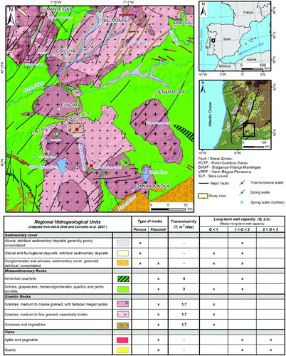
Figure 2. Regional framework of the study area (Alardo and Touca sites): (A) Morphotectonic general features from Northern Portugal (adapted from CitationBrum Ferreira, 1991); (B) Satellite image (compiled from Landsat 7 ETM + data, 2000/01; all IR colour, bands 7-4-5 = RGB; adapted from Global Land Cover Facility) and main hydromineral springs (adapted from CitationCarvalho et al., 2007); (C) Shaded relief and regional hydrogeology (adapted from CitationCarvalho et al., 2007); (D) Slope of the region.
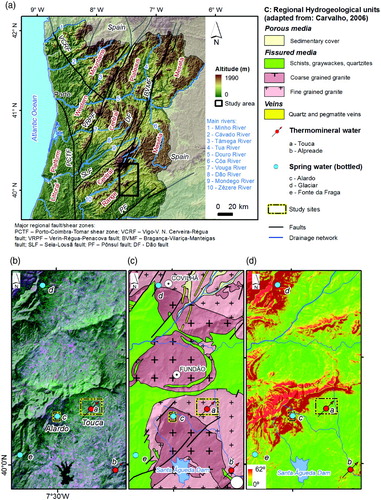
The Gardunha mountain system belongs to a wide range of ridges with a length of approximately 60 km, with a major trend NE-SW – the so-called ‘Cordilheira Central’ or Central Range (CitationBrum Ferreira, 1980; CitationRibeiro, 1949; CitationThadeu, 1949). This mountain rises from a large flattened area ( and ), at altitudes between 400 and 450 m, extending from its foothills to over 20 km south, near Idanha-a-Nova urban area. The North is bordered also by a flattened region, named ‘Cova da Beira’ (CitationRibeiro, 1939, Citation1949), which extends from Gardunha ridge, to the foothills of Estrela mountain (CitationVieira, Mora, & Ramos, 2003).
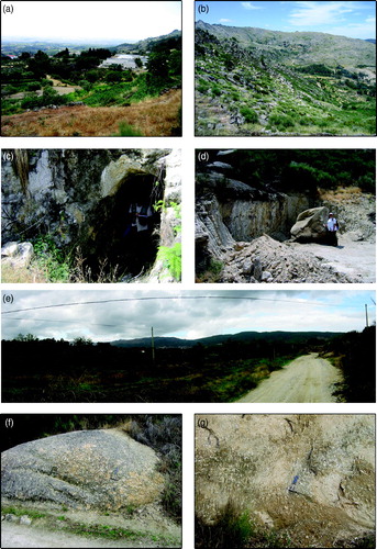
Locally, in the Alardo site the bedrock is mainly composed of moderate to slightly weathered (W 3 – W 1-2) granitic core stones. The Schmidt Hammer hardness tests carried out in that granite have shown a uniaxial compressive strength around 35 MPa. The highly weathered granite (W 4-5) outcrops are observed in sloped areas. In contrast, the Touca hydromineral site is dominated by highly weathered granite (W 4-5) in a large flattened area comprising gentle slopes (‘Cova da Beira’). In addition, a granitic sandy-clayey regolith has been identified, and a slight to moderately weathered (W 1-2 – W3) granite core stones also outcrop ().
Figure 3. Field aspects of the studied sites: (a) View of Alardo site and ‘Cova da Beira’ plains in the background; (b) General view of Gardunha mountain ridge; (c) Hydrogeological inventory mapping: water mine excavated in granite; (d) Granitic core stones and weathered granite in Gardunha sloped area; (e) View of Touca plains, with Gardunha mountain system in the background; (f/g) Outcrop and weathered granite in Touca site.
3. Methods and results
Geomorphological cartography had a widespread application in the oil industry, hydraulic engineering, geotechnical engineering, engineering geosciences, environmental consultancy, and planning (CitationGriffiths & Abraham, 2008; CitationTricart, 1958). A methodological approach for the preparation of applied geomorphological maps must be sufficiently flexible to meet the requirements of the end-user needs (CitationGriffiths & Abraham, 2008). Geovisualisation is particularly relevant to hydrologic systems as it brings new approaches and challenges in map design (e.g. CitationCascelli, Crestaz, & Tatangelo, 2012; CitationDykes, Maceachren, & Kraak, 2005; CitationFisher, Dykes, & Wood, 1993).
Recent technological advances have brought GIS cartographic techniques to the forefront as tools for recommending water management methods (e.g. CitationBallukraya & Kalimuthu, 2010; CitationChowdary, Rao, & Sarma, 2003; CitationJaiswal et al., 2003; CitationJha, 2011; CitationJha, Chowdhury, Chowdary, & Peiffer, 2007; CitationYeh, Lee, Hsu, & Chang, 2009). The multicriteria approach, which encompasses several types of layers of information (e.g. topography, climatology, lithology, structure, slope, drainage, geomorphology, hydrogeology, land cover/land use) has been greatly enhanced by the versatile development of GIS hardware and software (CitationEttazarini, 2007).
The basic data collection techniques of geology, geomorphology and hydrogeology have been applied in this study (e.g. CitationAssaad, Lamoreaux, Hughes, Wangfang, & Jordan, 2004; CitationBrewer, 2005; CitationDykes et al., 2005; CitationFisher et al., 1993; CitationFookes, Lee, & Griffiths, 2007; CitationPeterson, 2009; CitationSmith, Paron, & Griffiths, 2011). The terminology and recommendations of the International Society for Rock Mechanics (CitationISRM, 2007), Geological Society Engineering Group (CitationGSE, 1995) and the Committee on Fracture Characterisation and Fluid Flow (CitationCFCFF, 1996) were followed. In this study, the topographic maps (Portuguese Army Geographic Institute), the geological maps (former Portuguese Geological Survey), aerial orthophotos and also LandSat ETM+ and SPOT5 images has been used to build a series of thematic maps.
A geodatabase was created to organise the input data for analysis. This database includes information on geological features (lithology, structure, and weathering grade), land cover, drainage, slope, and rainfall, as well as other relevant information for the site investigation (, cf. Stage 1). Once all data were registered in the spatial database the data were weighted and overlay operations completed. This GIS analysis allowed the creation of several derivative map themes, in order to assess the spatial distribution and controls on groundwater infiltration. The identification of the explaining factors were compiled and revised from the selected bibliography (e.g. CitationBabar, 2005; CitationJha, 2011; CitationJha et al., 2007; CitationKrishnamurthy, Kumar, Jayaraman, & Manivel, 1996; CitationTeixeira et al., 2010; CitationYeh et al., 2009 and references therein). The weight and score for each factor have been calculated using the ‘Analytical Hierarchy Process’ method (e.g. CitationKim, Ahn, & Marui, 2009; CitationSaaty, 2008 and references therein). The intrinsic characteristics of each factor were largely accessed from data obtained during the field campaigns in both of the study sites, and some minor adjustments were made accordingly in the factors' weights and scores.
Figure 4. Conceptual flowchart of the hydrogeomorphological mapping methodology applied to the Alardo and Touca sites (Portugal).
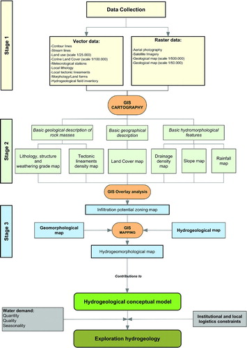
The factors used in the calculation of the potential groundwater infiltration were grouped in to three main categories (see details in CitationTeixeira, 2011; CitationTeixeira et al., 2010): geological description of rock masses, geographical description, and hydromorphological features (, cf. Stage 2). Each input map has its specific weight and score and was used to calculate groundwater infiltration potential areas. The grid data structure (a quadrangular block of cells with a pixel size of 1 × 1 m) was used, and each raster cell value is a result of the weighted sum of the input layers. The GIS overlay of these factors results in a map, which spatially reflects the index of infiltration potential, with values ranging from 0 to 100. This intermediate map was then overlaid with both the geomorphological map and the hydrogeological field-data inventory, to achieve an integrated hydrogeomorphological map (, cf. Stage 3).
For each study site, three different scenarios were computed, and the relative weight of some factors was changed to account for local conditions. Scenario 1 corresponds to a more balanced setting between all the presented parameters. In this scenario, lithology and structure/weathering grade, tectonic lineament density and slope have a greater importance in explaining the groundwater infiltration potential of each study site. In Scenario 2, relative weights of lithology and structure/weathering grade, tectonic lineament density and slope were maintained. However, the weights for land use and slope were increased, and the importance of drainage network density was reduced. Given the low spatial variability and minimum change in average annual rainfall, this parameter becomes less important in this scenario and, even less in Scenario 3. In this last scenario, the density of drainage network assumes a very low weight, and higher relative weights are given to lithology and structure/weathering grade, tectonic lineament density and slope, and slightly lower than those, land use. The construction, analysis and comparison of these scenarios were completed to help the development of the conceptual model for each study site. This contributed to an improved knowledge and management of the groundwater resources.
The main parameters related to the groundwater recharge areas were identified, as being: (i) moderate-to-highly weathered granitic rock (including arenisation layers); (ii) moderate-to-close fracturing; (iii) low slope areas at the highest elevations; and, (iv) agricultural and forest areas ().
Table 1. Summary of hydrogeological ‘favourability’ for potential infiltration on fissured hard-rock, focused in to groundwater recharge/discharge for the studied sites (adapted from CitationTeixeira et al., 2010).
4. Conclusions and outlook
Hydrogeomorphological mapping combines geological, geomorphological and hydrogeological features. The location of groundwater recharge/discharge areas becomes more perceptible when using potential groundwater infiltration.
The cross-check of geomorphological and hydrogeological features in a GIS-based environment provided a simple and efficient tool to support groundwater exploration. The approach contributes to hydrogeological conceptual model building, which is an important tool in the decision-making process, regarding water resources management and territory planning (CitationJha, 2011; CitationKudrna & Šindelářová, 2006). This approach is indispensable for the management and protection of a fragile resource, considering its utilisation in the thermal spa (Touca) and bottling water industries (Alardo).
The conceptual ground models based in Earth systems have proven their value in geology, hydrogeology and engineering geosciences (e.g. CitationBisson & Lehr, 2004; CitationBredehoeft, 2005; CitationCarvalho et al., 2005; CitationFookes, 1997; CitationGriffiths & Stokes, 2008; CitationLeGrand & Rosen, 2000; CitationShapiro, 2001; CitationTeixeira et al., 2010). With regard to water resources management it is important to balance the water demands (quality, quantity and seasonality), as well as institutional and local logistics. Groundwater-related activities (e.g. hydrogeological site investigations, identification of potential contamination areas, definition of wellhead protection areas) can be significantly improved with the help of GIS-based analysis and hydrogeomorphological and hydrogeological mapping techniques, leading to a more efficient and sustainable management of water resources.
Software
ESRI ArcGIS 9.3 was used for map data visualisation, overlay analysis and layout creation. All overlay analysis was performed using a raster file format, with a pixel resolution of 1 × 1 m. The 3D hydrogeomorphological conceptual model was built using ESRI ArcScene 9.3 and OCAD for Cartography 9.
Main Map: Hydrogeomorphological Mapping as a Tool in Groundwater Exploration
Download PDF (40.8 MB)Acknowledgements
This work was completed under the framework of the Labcarga|ISEP re-equipment program (IPP-ISEP|PAD'2007/08) and Centre GeoBioTec|UA (PEst-C/CTE/UI4035/2011-2012). JT was supported by a doctoral scholarship from the Portuguese Foundation for Science and Technology (SFRH/BD/29762/2006). We acknowledge the anonymous reviewers for the constructive comments that helped to improve the clarity of the manuscript. The present paper is dedicated to the late Professor Jean Tricart (1920–2003) eminent French geomorphologist, who launches the basis of the hydrogeomorphological cartography applied to the environment, groundwater and engineering.
Related Research Data
References
- Assaad , F. A. , Lamoreaux , P. E. , Hughes , T. H. , Wangfang , Z. and Jordan , H. 2004 . Field methods for geologists and hydrogeologists , 420 Berlin : Springer-Verlag . doi: 10.1007/978-3-662-05438-3
- Babar , M. 2005 . Hydrogeomorphology: Fundamentals, applications and techniques , 274 New Delhi : New India Publishing Agency .
- Ballukraya , P. N. and Kalimuthu , R. 2010 . Quantitative hydrogeological and geomorphological analyses for groundwater potential assessment in hard rock terrains . Current Science , 98 ( 2 ) : 253 – 259 .
- Bisson , R. A. and Lehr , J. H. 2004 . Modern groundwater exploration: Discovering new water resources in consolidated rocks using innovative hydrogeologic concepts, exploration, drilling, aquifer testing and management methods , 309 Hoboken, NJ, USA : John Wiley & Sons . doi: 10.1002/0471660833
- Bredehoeft , J. D. 2005 . The conceptualization model problem: Surprise . Hydrogeology Journal , 13 ( 1 ) : 37 – 46 . doi: 10.1007/s10040-004-0430-5
- Brewer , C. A. 2005 . Designing better maps: A guide for GIS users , 220 Redlands , , CA, USA : ESRI Press .
- Brum Ferreira , A. 1980 . Surfaces d'aplanissement et tectonique récente dans le Nord de la Beira (Portugal) . Revue Géologie Dynamique Géographie Physique , 22 ( 1 ) : 51 – 62 .
- Brum Ferreira , A. 1991 . Neotectonics in Northern Portugal: a geomorphological approach . Zeitschrift für Geomorphologie , 82 : 73 – 85 .
- Carvalho , J. M. 1996 . Mineral water exploration and exploitation at the Portuguese Hercynian Massif . Environmental Geology , 27 ( 3 ) : 252 – 258 . doi: 10.1007/BF00770439
- Carvalho , J. M. 2006 . Prospecção e pesquisa de recursos hídricos subterrâneos no Maciço Antigo Português: Linhas metodológicas , 292 Aveiro University . (unpublished PhD Thesis)
- Carvalho , J. M. , Chaminé , H. I. , Afonso , M. J. , Espinha Marques , J. , Medeiros , A. , Garcia , S. , Gomes , A. , Teixeira , J. and Fonseca , P. E. 2005 . “ Productivity and water costs in fissured-aquifers from the Iberian crystalline basement (Portugal): Hydrogeological constraints ” . In Water, mining and environment: Book homage to professor Rafael Fernández Rubio , Edited by: López-Geta , J. A. , Pulido Bosch , A. and Baquero Úbeda , J. C. 193 – 207 . Madrid : Instituto Geológico y Minero de España .
- Carvalho , J. M. , Espinha Marques , J. , Afonso , M. J. and Chaminé , H. I. 2007 . Prospecção e pesquisa de recursos hidrominerais e de água de nascente no Maciço Antigo Português . Boletim de Minas, Lisboa , 42 ( 2 ) : 161 – 196 .
- Cascelli , E. , Crestaz , E. and Tatangelo , F. 2012 . “ Cartography and geovisualization in groundwater modelling ” . In Geographic information analysis for sustainable development and economic planning , Edited by: Borruso , G. , Bertazzon , S. , Favretto , A. , Murgante , B. and Torre , C. M. 49 – 67 . New technologies . IGI Global
- Chowdary , V. M. , Rao , N. H. and Sarma , P. B. S. 2003 . GIS-based decision support system for groundwater assessment in large irrigation project areas . Agricultural Water Management , 62 ( 3 ) : 229 – 252 . doi: 10.1016/S0378-3774(03)00144-6
- Cloots-Hirsch , A.-R. and Tricart , J. 1978 . L'eau, facteur écologique de l'aménagement: L'exemple de l'Alsace . Revue de géographie de Lyon , 53 ( 4 ) : 339 – 354 . doi: 10.3406/geoca.1978.1235
- Committee on Fracture Characterization and Fluid Flow (CFCFF) . 1996 . “ Rock fractures and fluid flow: Contemporary understanding and applications ” . In National Research Council , 568 Washington, DC : The National Academies Press .
- Dunne , T. 1994 . Hydrogeomorphology: An introduction . Transactions. Japanese Geomorphological Union , 15A : 1 – 4 .
- Dykes , J. , Maceachren , A. M. and Kraak , M.-J. 2005 . “ Exploring geovisualization ” . In International cartographic association , Edited by: Dykes , J. , Maceachren , A. M. and Kraak , M.-J. 710 Oxford , UK : Elsevier .
- Ettazarini , S. 2007 . Groundwater potentiality index: A strategically conceived tool for water research in fractured aquifers . Environmental Geology , 52 ( 3 ) : 477 – 487 . doi: 10.1007/s00254-006-0481-0
- Fisher , P. F. , Dykes , J. A. and Wood , J. D. 1993 . Map design and visualization . The Cartographic Journal , 30 ( 2 ) : 136 – 142 . doi: 10.1179/000870493787859960
- Fookes , P. G. 1997 . Geology for engineers: The geological model, prediction and performance . Quarterly Journal of Engineering Geology and Hydrogeology , 30 : 293 – 424 . doi: 10.1144/GSL.QJEG.1997.030.P4.02
- Fookes , P. G. , Lee , E. M. and Griffiths , J. S. 2007 . Engineering geomorphology: Theory and practice , 288 Dunbeath, Caithness, Scotland, UK : Whittles Pub .
- Freeze , R. A. and Cherry , J. A. 1979 . Groundwater , 604 New Jersey, USA : Prentice-Hall .
- Gama Pereira , L. C. 1976 . Notícia sobre o ‘Complexo Xisto-Grauváquico’ entre Capinha e Penamacor (Beira-Baixa, Portugal) . Mem. Not. Pub. Mus. Lab Miner. Geol. Univ. Coimbra , 82 : 61 – 66 .
- Geological Society Engineering Group Working Party Report (GSE) . 1995 . The description and classification of weathered rocks for engineering purposes . Quarterly Journal of Engineering Geology of Geological Society , 28 ( 3 ) : 207 – 242 . doi: 10.1144/GSL.QJEGH.1995.028.P3.02
- Gregory , K. J. 1979 . Hydrogeomorphology: How applied should we become? . Progress in Physical Geography , 3 ( 1 ) : 84 – 101 . doi: 10.1177/030913337900300103
- Griffiths , J. S. and Abraham , J. K. 2008 . Factors affecting the use of applied geomorphology maps to communicate with different end-users . J. Maps , 4 ( 1 ) : 201 – 210 . doi: 10.4113/jom.2008.89
- Griffiths , J. S. and Stokes , M. 2008 . Engineering geomorphological input to ground models: An approach based on earth systems . Quarterly Journal of Engineering Geology and Hydrogeology , 41 : 73 – 91 . doi: 10.1144/1470-9236/07-010
- International Society for Rock Mechanics (ISRM) . 2007 . “ The complete ISRM suggested methods for characterization, testing and monitoring, 1974–2006 ” . In Suggested methods prepared by the commission on testing methods , Edited by: Ulusay , R. and Hudson , J. A. 628 Ankara , Turkey : ISRM & ISRM Turkish National Group .
- Jaiswal , R. K. , Mukherjee , S. , Krishnamurthy , J. and Saxena , R. 2003 . Role of remote sensing and GIS techniques for generation of groundwater prospect zones towards rural development: an approach . International Journal of Remote Sensing , 24 ( 5 ) : 993 – 1008 . doi: 10.1080/01431160210144543
- Jha , M. K. 2011 . “ GIS-Based groundwater modeling: an integrated tool for managing groundwater-induced disasters ” . In Aquifers: Formation, transport and pollution, environmental science , Edited by: Laughton , R. H. 149 – 190 . Hauppauge , N.Y : Engineering and Technology series, Nova Science Pub. Inc .
- Jha , M. K. , Chowdhury , A. , Chowdary , V. and Peiffer , S. 2007 . Groundwater management and development by integrated remote sensing and geographic information systems: Prospects and constraints . Water Resources Management , 21 ( 2 ) : 427 – 467 . doi: 10.1007/s11269-006-9024-4
- Kim , G.-B. , Ahn , J.-S. and Marui , A. 2009 . Analytic hierarchy models for regional groundwater monitoring well allocation in Southeast Asian countries and South Korea . Environmental Earth Sciences , 59 : 325 – 338 . doi: 10.1007/s12665-009-0029-1
- Krishnamurthy , J. , Kumar , N. V. , Jayaraman , V. and Manivel , M. 1996 . An approach to demarcate ground water potential zones through remote sensing and a geographical information system . International Journal of Remote Sensing , 17 ( 10 ) : 1867 – 1884 . doi: 10.1080/01431169608948744
- Kudrna , K. and Šindelářová , M. 2006 . Principles of hydrogeomorphology as a basic precondition for solution of territorial structure of unitary system of agricultural, forest and water management . Journal of Central European Agriculture , 7 ( 4 ) : 669 – 676 .
- Legrand , H. E. and Rosen , L. 2000 . Systematic makings of early stage hydrogeologic conceptual models . Ground Water , 38 ( 6 ) : 887 – 893 . doi: 10.1111/j.1745-6584.2000.tb00688.x
- Leopold , L. B. 1982 . “ Field data: The interface between hydrology and geomorphology, scientific basis of water-resource management ” . In Studies in geophysics , 105 – 108 . Washington , D.C : The National Academies Press .
- Okunishi , K. 1991 . Hydrogeomorphological interactions: A review of approach and strategy . Transactions, Japanese Geomorphological Union , 12 : 99 – 116 .
- Okunishi , K. 1994 . Concept and methodology of hydrogeomorphology . Transactions, Japanese Geomorphological Union , 15A : 5 – 17 .
- Oliveira , J. T. , Pereira , E. , Ramalho , M. , Antunes , M. T. and Monteiro , J. H. 1992 . Carta geológica de Portugal, escala 1/500000 , Lisboa : Serviços Geológicos de Portugal .
- Peterson , G. N. 2009 . GIS cartography: A guide to effective map design , 227 Boca Raton, FL, USA : CRC Press, Taylor Francis Group .
- Ribeiro, A., Munhá, J., Dias, R., Mateus, A., Pereira, E., Ribeiro, L., Fonseca, P. E., Araújo, A., Oliveira, J. T., Romão, J., Chaminé, H. I., Coke, C. & Pedro, J. (2007). Geodynamic evolution of the SW Europe variscides, Tectonics, 26, TC6009, 24 pp. doi: 10.1029/2006TC002058
- Ribeiro , O. 1939 . Sur la morphologie de la Basse Beira . Bull. Assoc. Géograph. Franç. , 122 : 113 – 122 .
- Ribeiro , O. 1949 . “ Le Portugal Central. Livret-guide de l'excursion C, Union Géographique Internationale ” . In XVI Congrès International de Géographie , 180 Lisbonne .
- Saaty , T. L. 2008 . Decision making with the analytic hierarchy process . Int. J. Services Sciences , 1 ( 1 ) : 83 – 98 . doi: 10.1504/IJSSCI.2008.017590
- Scheidegger , A. E. 1973 . Hydrogeomorphology: Review . J. Hydrology , 20 ( 3 ) : 193 – 215 . doi: 10.1016/0022-1694(73)90061-9
- Shapiro , A. M. 2001 . Effective matrix diffusion in kilometer-scale transport in fractured crystalline rock . Water Resources Research , 37 ( 3 ) : 507 – 522 . doi: 10.1029/2000WR900301
- Sidle , R. C. and Onda , Y. 2004 . Hydrogeomorphology: Overview of an emerging science. Hydrological Processes . 18 ( 4 ) : 597 – 602 . doi: 10.1002/hyp.1360
- Smith , M. , Paron , P. and Griffiths , J. 2011 . Geomorphological mapping: Methods and applications . Developments in Earth Surface Processes , 15 (p. 610). Oxford, UK: Elsevier
- Sophocleous , M. 2002 . Interactions between groundwater and surface water: The state of the science . Hydrogeology Journal , 10 ( 1 ) : 52 – 67 . doi: 10.1007/s10040-001-0170-8
- Surrette , M. , Allen , D. and Journeay , M. 2008 . Regional evaluation of hydraulic properties in variably fractured rock using a hydrostructural domain approach . Hydrogeology Journal , 16 ( 1 ) : 11 – 30 . doi: 10.1007/s10040-007-0206-9
- Teixeira , J. 2011 . Hidrogeomorfologia e sustentabilidade de recursos hídricos subterrâneos , 504 Aveiro University . (unpublished PhD Thesis)
- Teixeira , J. , Chaminé , H. I. , Espinha Marques , J. , Gomes , A. , Carvalho , J. M. , Pérez-Alberti , A. and Rocha , F. 2010 . “ Integrated approach of hydrogeomorphology and GIS mapping to the evaluation of ground water resources: An example from the hydromineral system of Caldas da Cavaca, NW Portugal ” . In Global groundwater resources and management, selected papers from the 33rd international geological congress, general symposium: Hydrogeology , Edited by: Paliwal , B. S. 227 – 249 . Oslo (Norway) : Scientific Publishers (India), Jodhpur .
- Thadeu , D. 1949 . A cordilheira central entre as serras da Gardunha e de São-Pedro-do Açor . Bol. Soc. Geol. Portg. , 8 ( 1/2 ) : 1 – 20 .
- Tricart , J. 1958 . Géomorphologie et aménagement hydrauliques . L'universitaire, Sciences et Techniques , 1 : 31 – 46 .
- Tricart , J. 1961 . Géomorphologie et eaux souterraines, IAHS Red Book Series (56), 22–27
- Tricart , J. , Cloots-Hirsch , A.-R. and Griesbach , J. C. 1965 . Géomorphologie et eaux souterraines dans le bassin de Santiago du Chili. Bulletin de la Faculté des Lettres de Strasbourg 43(7) 605–674 , T.I.L.A.S. (Travaux de l'Institut d'Études latino-américaines de l'Université de Strasbourg) .
- Vieira , G. T. , Mora , C. and Ramos , M. 2003 . Ground temperature regimes and geomorphological dynamics in a Mediterranean mountain (Serra da Estrela, Portugal) . Geomorphology , 52 : 57 – 72 . doi: 10.1016/S0169-555X(02)00248-9
- Yeh , H.-F. , Lee , C.-H. , Hsu , K.-C. and Chang , P.-H. 2009 . GIS for the assessment of the groundwater recharge potential zone . Environmental Geology , 58 ( 1 ) : 185 – 195 . doi: 10.1007/s00254-008-1504-9