Abstract
The landform ensemble of the Tsetseg Nuur Basin in Western Mongolia provides an archive for periods of different geomorphologic processes induced by changing climate conditions during the Holocene and late Pleistocene times. The geomorphologic map of Tsetseg Nuur basin in the Mongolian Altai illustrates the spatial relation and interaction between different types of sedimentation in semi-arid regions of Central Asia. The map is an instrument to visualize the geomorphologic settings, providing valuable information to distinguish periods of geomorphologic processes and to analyze the landscape evolution. This enables the creation of a relative morphostratigraphy of periods with different hydrological environments, mainly marked by the stages of lake level evolution in an interior drainage basin. The relative chronology calculated from the map receives an absolute chronostratigraphy through radiometric dating from selected sections investigated during field-work.
1. Introduction
Extreme variations in climate conditions occurred during the Pleistocene with alternating glacial and interglacial cycles. More minor variations in amplitude have occurred during the Holocene, however they have not exclusively lead to changing glacier extents in the mountainous areas of semi-arid Central Asia. More local variations to fluvial and aeolian morphodynamic processes have occurred, particularly changing lake levels of terminal lakes in interior basins. In particular, during dry periods fine material is blown out from dried-out lakes or riverbeds and deposited in the surrounding area as aeolian sediment or dune fields.
For the large terminal lakes in the so-called ‘Valley of the Great lakes’ in western Mongolia, paleostrandlines have been investigated (CitationGrunert, Lehmkuhl, & Walther, 2000; CitationTarasov & Harrison, 1998), along with overflow into the Gobi desert to the south-east (CitationMurzaev, 1954). Their catchments are composed of multiple massifs and intermediate lakes, with outflow widely distributed. This creates complex and polygenetic hydrological regimes, which are poorly explained by a single climate-induced morphological component. In contrast, the small closed catchment area of Zezeg Nuur basin () provides considerably better preconditions to deduce the climate environment from paleo-lake levels and geomorphologic processes.
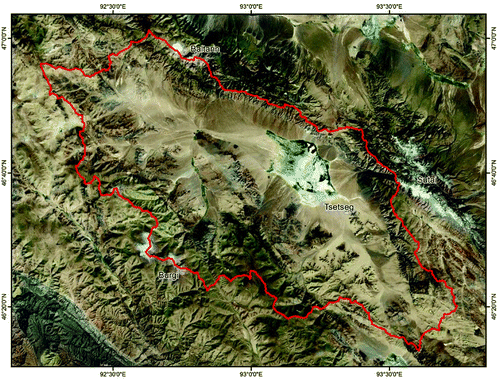
Figure 1. Landsat satellite image of the Tsetseg Nuur catchment area (Provided as Basemap-Layer in ArcGis 10 by ESRI)
The results concerning the spatial pattern of different morphological structures derived from field work and remote sensing are combined in the accompanying geomorphological map (see Main Map) to highlight the relationship and timing of different morphodynamic processes. The chronological classification of periods with different geomorphological processes provides evidence to distinguish between temperature- or precipitation-induced environmental change. Finally, radiometric dating helps to integrate the findings into the global climate trend during the Late Pleistocene and Holocene.
2. The study area
The Tsetseg Nuur Basin is situated in Central Asia (93°14′E/46°40′N) at the eastern margin of the Mongolian Altai Mountains in the transition region toward the Gobi Altai. It is a north-west to south-east trending tectonic basin of interior drainage (). The recent lake level of Tsetseg Nuur lies at 1686 m asl and the surrounding mountains rise up to elevations of more than 4000 m asl.
The dry and cold continental climate is characterized by a low mean annual air temperature of 0.1°C and an annual precipitation of 60 mm in the basin and up to 400 mm in the high mountain ranges. Eighty percent of the precipitation occurs during the summer months (Klinge, Citation2001; Klinge, 2002).
Desert steppe and mountain steppe vegetation is widely distributed and becomes less dense at lower elevations within the semi-arid basin. Although larch trees are represented at the northern slope of Sutai Mountain, there are no woods in the catchment of Tsetseg Nuur basin (CitationKlinge, Böhner, & Lehmkuhl, 2003). The playas and the margins surrounding the modern lake are covered by dense grassland with salt- and drought-tolerant plants.
A detailed description of the geological and tectonical environment is provided by CitationCunningham, Windley, and Dorjnamjaa (1996). The active Tsetseg thrust fault at the border to the northern and eastern mountain ranges, sharply divide the sediments in the basin from the metamorphic sedimentary and volcanic rocks of the mountains. Most parts of the basin consist of Quaternary deposits such as alluvium, fanglomerats, lake sediments and aeolian sediments.
3. Methods
During fieldwork at Tsetseg Nuur the landforms, such as different lake deposits, dunes, alluvial fans and the distribution of erosion channels, were mapped in detail. Field mapping was performed on the basis of topographic maps in a scale of 1:100,000. The elevations provided by the 1:100,000 topographic maps coincide with the Shuttle Radar Topography Mission digital elevation model (SRTM). In addition, aerial photographs from 1968 at a scale of approximately 1:45,000 were used to identify selective local elements, such as the different paleostrandlines, dune fields or gully erosion. The distribution of the different lake level systems was mapped by beach ridges and cliffs using aerial photographs and satellite images (). At several locations the oldest paleostrandlines are covered by younger alluvial fans. Therefore the true maximum lake extent cannot be determined precisely and the map describes a minimum value using dotted lines, which follow the actual contour lines.
4. Geomorphologic settings
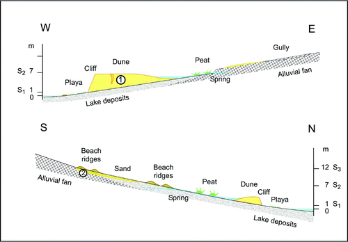
The landform assemblage described in the geomorphologic map originates from periods of different erosion and accumulation processes, which are triggered by different late Quaternary climatic conditions and tectonic movements. While the map describes the spatial distribution, location and extent of geomorphologic features, two cross-sections show the stratigraphic position of lake terraces and sediments (). The geomorphologic conditions leading to the different sediments and erosion features are described in detail. The combination of field work results and mapping enables the creation of a chronology outlining the phases of different geomorphologic processes.
Figure 2. Schematic cross-sections of Tsetseg Nuur basin, showing the positions of lake levels and sediments.
4.1. Aeolian sediments
Two types of aeolian material transport and accumulation in the basin, affected by prevalent north-western winds, can be distinguished by their color on the aerial photographs and satellite images (). Dune fields east and southeast of the modern lake have a bright white color and sandy aeolian sediments at the foothills in the south-eastern part of the basin are brown to yellow.
The dunes close to the lake are composed of sandy aggregates of gray silty material, which incorporate remnants of lacustrine molluscs. The high content of carbonate and gypsum shows that these sediments are removed playa and lake deposits, which were blown out during a dry-out phase of the lake. Radiocarbon-dating of the mollusc samples yield a C14-Age of 11,240 ± 280 years BP (Hv22525) (calibrated Age: 13,167 ± 281 years cal BP), while optical stimulated luminescence dating (OSL) from the dune sediments produced an age of 4.5 ± 1.8 ka BP (A138, for methods see: CitationLehmkuhl, Klinge, Rees-Jones, & Rhodes, 2000), (section no. 1). These dates are evidence of a wet phase with high lake level during late Pleistocene and a mid-Holocene dry-out period with prevailing aeolian processes. Later the lake developed again and eroded a cliff into these dunes.
Sandy material occurs as outer facies in front of the alluvial fans in the western and southern part of the basin and as aeolian cover on the foothills in the south-eastern region. This material was blown out from the fluvial deposits. Sand predominantly originates from the granite rocks in the southern part of the basin as they are an excellent source of sand size particles. In the southern part of the basin the highest and therefore oldest preserved lake levels have built up beach ridges consisting of gravel a few centimeters in diameter upon the sand sediment. A sample taken from material below the oldest beach ridge, yield a thermo-luminescence (TL) age of 31.4 ± 3.6 ka BP and an infrared stimulated luminescence dating (IRSL) of 31.1 ± 3.8 ka BP (LE1, for methods see: CitationLehmkuhl, Frechen, & Zander, 2007), (section no. 2).
4.2. Alluvial fans and fluvial erosion
The basin is surrounded by mountain ranges with an interior belt of alluvial fans. Due to neotectonic movements, the alluvial fans are sharply separated toward the mountain front, where different systems of fluvial terraces occur. At their outer limit they blend superficially with the lake sediments. The map shows that the alluvial fans have been reworked recently and are incised by discontinuous erosion channels and gully erosions. This illustrates that the main accumulation phase of alluvial fans took place in former times, probability during Pleistocene periods when material was prevalent due to the extensive glacial and periglacial processes (CitationLehmkuhl, 2000). The lower mountain areas are cut by sharp V-shaped valleys, which were formed by the same geomorphologic process defined as steppe-gully-erosion (CitationLehmkuhl & Lang, 2001).
4.3. Glacial and periglacial landforms
The upper mountains have more gentle slopes affected by periglacial processes. Two planation surfaces in intermediate elevations of 2700–3300 m asl. and 3800–4000 m asl. shape the mountain tops. Modern plateau glaciers are restricted to the higher planation surface and have a very small surface area. They occur exclusively on the northern margin of the basin at Sutai Mountain and Baltarin Nuruu.
4.4. Hydrological features
Only one perennial river (Ulaan Orsiin Gol) flows down to the basin from the south-western Burgi Mountains. The permanent rivers in the headwater lose their surface water through evaporation and percolation on their way toward basin and do not reach the lake. The dotted blue lines indicate the seasonal and daily range of river flow. Several springs accompanied by swamp and peat vegetation occur on the playas in front of the alluvial fans, where the groundwater level approaches the surface.
4.5. Lake level evolution
Due to the very flat basin small vertical changes of lake level reflect a large horizontal change of lake extent. Higher lake levels are indicated by up to 0.5 m high beach ridges consisting of pebble, from lacustrine sediments and from a cliff eroded into the nearby dunes. The relative chronology of lake development receives a time frame from the radiometric dating. The following main stages of lake development can be outlined:
| 1. | The first and oldest phase of low lake level is indicated by sedimentation, deflation and relocation of sandy material. Luminescence dating of 33 ka BP of the aeolian sand coincides with the Interstadial (OIS 3) of the last Glacial cycle. Widespread periglacial processes delivered the debris to form the alluvial fans and provided the sand for simultaneous aeolian mobilization. | ||||
| 2. | The highest lake level (S3) which lies 12 m above the modern lake () and occurred between the LGM (OIS 2) and Late Glacial. This is indirectly confirmed by the radiocarbon dating of the mollusc fossils as a minimum age of 13 ka cal BP. The highest lake level was probably affected by meltwater from the retreating glaciers (CitationGrunert et al., 2000) as well as by reduced evaporation (CitationKomatsu, Brantingham, Olsen, & Baker, 2001). This is indicated by a system of several beach ridges consisting of fine gravel above the sand layer. It is preserved exclusively in the southern part of the basin, where the relief is flatter and is lower than in the northern part. Due to the active tectonic movement at all other locations, the highest paleostrandlines are reworked and covered by younger alluvial debris. | ||||
| 3. | A main trend of gradual lake shrinking found its last significant stage in the lake level system S2 in the mid-Holocene, which is marked by beach ridges 7 m above the modern playa. In contrast to the predominant clastic sediments of lake level system S3, the lacustrine sediments of lake level system S2 originate from chemical and biogenic precipitation. | ||||
| 4. | Since mid-Holocene the lake dried-out completely and lake deposits were blown out as sandy concretions and accumulated in the dune fields at the eastern and south-eastern side of the basin partly covering the paleostrandlines S2. The luminescence dating of the dune material gave an age of about 4.5 ka BP. | ||||
| 5. | The erosion of a cliff into the dunes shows that beyond this dry period the lake re-developed again to a smaller extent. However, the lake remained divided into several sub-parts between these sediments. Since this late Holocene lake level S1, which lies about 1 m above the modern lake, the lake kept shrinking to the contemporary size. | ||||
5. Conclusions
The landscape of the semi-arid regions in Central Asia are a combination of modern and past geomorphologic processes, which are strongly controlled by changing climate conditions. The extensions of the terminal lakes reflect the hydrological situation of interior drainage basins. It was shown that main lake level stages and their spatial relation to the landform ensemble can clearly be identified in aerial photographs and satellite images for the Tsetseg Nuur Basin. Results from field investigation, laboratory examination and remote sensing come together in a complex map design. Geomorphologic mapping is a valuable instrument to visualize the relationship between different types of sediments. The spatial arrangement of the landform assemblage illustrates the landscape evolution and helps to explain multiphase geomorphologic processes in time and space.
Software
The map was developed out on copies of topographic maps at a scale of 1:100,000. These sketch maps were scanned and the digital map was redrawn and designed using Macromedia Freehand 9.0. The overview map was created using Esri ArcMap 10, where a Landsat-Image was imported as basemap-layer.
Main Map: Geomorphologic Map of Tsetseg Nuur Basin in the Mongolian Altai
Download PDF (3.5 MB)Acknowledgements
The authors would like to thank the German Science Foundation DFG for the financial support of the expeditions to Western Mongolia. We also gratefully thank the Mongolian Academy of Sciences for the excellent collaboration, in particular Dr. Dortschgotov and Dr. Batkhishig for their help in the fields and the organization around the trip.
References
- Cunningham , W. D. , Windley , B. F. and Dorjnamjaa , D. 1996 . Late Cenozoic transpression in southwestern Mongolia and the Gobi Altai Tien Shan connection . Earth and Planetary Science Letters , 140 : 67 – 81 . (doi:10.1016/0012-821X(96)00048-9)
- Grunert , J. , Lehmkuhl , F. and Walther , M. 2000 . Palaeoclimatic evolution of the Uvs Nuur Basin and adjacent areas (Western Mongolia) . Quaternary International , 65/66 : 171 – 192 . (doi:10.1016/S1040-6182(99)00043-9)
- Klinge , M. 2001 . Glazialmorphologische Untersuchungen im Mongolischen Altai als Beitrag zur jungquartären Klimageschichte der Westmongolei . Aachener Geographische Abhandlungen , 35 : 125
- Klinge , M. , Böhner , J. and Lehmkuhl , F. 2003 . Climate patterns, snow- and timberlines in the Altai Mountains, Central Asia . Erdkunde , 57 : 296 – 308 . (doi:10.3112/erdkunde.2003.04.04)
- Komatsu , G. , Brantingham , P. J. , Olsen , J. W. and Baker , V. R. 2001 . Paleoshoreline geomorphology of Böön Tsagaan Nuur, Tsagaan Nuur and Orog Nuur: The Valley of Lakes, Mongolia . Geomorphology , 39 : 83 – 98 . (doi:10.1016/S0169-555X(00)00095-7)
- Lehmkuhl , F. 2000 . Alluvial fans and pediments in Western Mongolia and their implications for neotectonic events and climatic change . Berliner Geowissenschaftliche Abhandlungen, Reihe A , 205 : 14 – 21 .
- Lehmkuhl , F. , Frechen , M. and Zander , A. 2007 . Luminescence chronology of fluvial and aeolian deposits in the Russian Altai (Southern Siberia) . Quaternary Geochronology , 2 : 195 – 201 . (doi:10.1016/j.quageo.2006.04.005)
- Lehmkuhl , F. , Klinge , M. , Rees-Jones , J. and Rhodes , E. J. 2000 . Late Quaternary aeolian sedimentation in central and south-eastern Tibet . Quaternary International , 68–71 : 117 – 132 . (doi:10.1016/S1040-6182(00)00038-0)
- Lehmkuhl , F. and Lang , A. 2001 . Geomorphological investigations and luminescence dating in the southern part of the Khangay and the Valley of the Gobi Lakes (Central Mongolia) . Journal of Quaternary Sciences , 16 : 69 – 87 . (doi:10.1002/1099-1417(200101)16:1<69::AID-JQS583>3.0.CO;2-O)
- Murzaev , E. M. 1954 . Die Mongolische Volksrepublik. - Physisch-geographische Beschreibung 521 Gotha. VEB Geographisch-Kartographische Anstalt
- Tarasov, E., and Harrison, S. P. (1998). Lake status records from the former Soviet Union and Mongolia: a continental-scale synthesis. In: Frenzel, B. & Harrison, S.P. (Edit.): ‘Palaeohydrology as reflected in lake level changes as climatic evidence for Holocene times.’ Palaeoclimatic Research 25, 115–130.