Abstract
This paper presents results from the first regional statistical analysis of soils developed on till in Northern Ireland, using the Geological Survey of Northern Ireland's Tellus geochemical database. Till geochemistry is largely determined by its parent bedrock and soils developed on tills are known to inherit this geochemical signature. Soil geochemistry from areas of till can therefore be used to establish sediment provenance which in turn provides information on palaeo ice flow directions and ice sheet history. In this study, we use Principal Component Analysis to establish geochemical groupings that can be related back to likely bedrock parent material for the tills in the region. The maps, presented here at 1:445,000 scale, show the results of the first regional investigation of soil geochemistry of part of the northern sector of the Irish Ice Sheet. The results indicate that the upper surface of the majority of tills in the study area have a close relationship to local bedrock with rapid geochemical changes observed at lithological boundaries. This suggests that tills in this sector of the Irish Ice Sheet are primarily local in origin, indicating rapid entrainment of bedrock and low rates of evacuation of debris to the ice margin.
1. Introduction
Ice sheets are an integral part of the global climate system and investigating their behaviour provides information on how they respond to and drive climatic changes (e.g. CitationBroecker, 1994; CitationMcCabe & Clark, 1998). Reconstructing the dynamic history of former ice sheets relies heavily on geomorphological interpretations of drumlins and ribbed moraines which are used to establish ice flow patterns through time (e.g. CitationBoulton & Clark, 1990; CitationBoulton, Dongelmans, Punkari, & Broadgate, 2001; Clark, Knight, & Gray, Citation2000; CitationGreenwood & Clark 2009; CitationGreenwood & Kleman, 2010; CitationKleman & Borgström, 1996; CitationPunkari, 1997; CitationSarala, 2006). However, recent work on these bedforms indicates that using morphology alone to establish ice flow direction may not be definitive, particularly if small study areas and sample sizes are used (CitationDunlop & Clark, 2006; CitationSpagnolo, Clark, Hughes, Dunlop, & Stokes, 2010). Also, not all areas of glaciated terrain experienced a bedforming event or retain evidence of one, though glacial erosional forms such as striae may provide ice flow alignment data if present on exposed bedrock surfaces (Glasser & Bennett, Citation2004; Iverson, Citation1991; Smith & Knight, Citation2011). It is therefore appropriate to consider other approaches that are not reliant on but may compliment geomorphological reconstructions. An alternative method, not previously applied to regional reconstructions of the Irish Ice Sheet, is the use of geochemistry to establish the provenance of glacial deposits. This technique has its roots in mineral prospecting where geochemistry is used to establish the provenance and dispersal pattern of valuable mineral deposits that have underwent transport by ice during glaciation (e.g. CitationAario & Peuraniemi, 1992; CitationKauranne, 1958; CitationKlassen, 2001; CitationKlassen & Thompson, 1993; CitationMcClenaghan, Thorleifson, & DiLabio, 2000; CitationParent, Paradis, & Doiron, 1996; CitationPeuraniemi, Aario, & Pulkkinen, 1997; CitationSarala, Rossi, Peuraniemi, & Ojala, 2007; CitationVeillette, 2004). The geochemical signature of the till is inherited from the bedrock parent material which allows till provenance to be established (CitationBoston, Evans, & Ó'Cofaigh, 2010). It has been demonstrated that soils developed on tills inherit the till geochemical signature so that analysing soils can be used to establish the regional ice flow patterns of former ice sheets (CitationScheib & Lee, 2010; CitationScheib, Dunlop, & Cooper, 2010; CitationScheib, Lee, Breward, & Riding, 2011).
The main map presented here (CitationDempster et al., 2013), show the results of the first regional-scale geochemical analysis of soils developed on tills in Northern Ireland. They provide a detailed overview of the regional geochemistry and can be used to develop a greater understanding of till provenance in this sector of the British Irish Ice Sheet (BIIS) and for testing existing conceptual models of ice sheet behaviour reconstructed from the landform and sedimentary record.
2. Regional geology of Northern Ireland
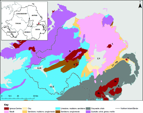
The north of Ireland hosts a diverse range of bedrock () (CitationMitchell, 2004) which can be broadly divided into four main domains based on age. The oldest rocks are found mainly in counties Londonderry and Tyrone and are Meso- to Neoproterozoic and include the Dalradian Supergroup, which consists of deformed metamorphosed sandstones and mudstones with basic intrusive and extrusive units (CitationCooper & Johnston, 2004a). Ordovician-Silurian age bedrock is present in counties Down and Armagh and is composed of greywacke sandstone and mudstone turbidite sequences containing numerous minor intrusions (CitationAnderson, 2004). The Tyrone Igneous Complex is Ordovician to early Silurian in age and is composed of volcanic and plutonic rocks with associated marine sediments (CitationCooper et al., 2011). The Devonian and Carboniferous are mixed siliclastic and carbonate sediment sequences and include significant andesite bodies such as the Barrack Hill Andesite in Co. Tyrone (CitationMitchell, 2004a, Citation2004b). The early Devonian Newry Igneous Complex (CitationCooper & Johnston, 2004b) intrudes the Ordovician-Silurian turbidite sequences of counties Down and Armagh. Carboniferous rocks outcrop mainly in counties Fermanagh and Armagh, with outliers in Tyrone and Londonderry. The youngest bedrock is the Palaeogene Antrim Lava Group, Mourne Granites and Slieve Gullion intrusive complexes (CitationCooper, 2004; CitationCooper & Johnston, 2004c). A rhyolite complex associated with the Antrim Lava Group is located in county Antrim. Numerous Palaeogene dyke swarms and sills including the Scrabo complex are intruded throughout the region (CitationCooper et al., 2012). Mesozoic sediments are exposed around the fringes of the Antrim Plateau and in the Lagan Valley-Newtownards Basin (CitationMitchell 2004c, Citation2004d, Citation2004e).
Figure 1. Simplified geology of the north of Ireland based on the 1:250,000 bedrock map (CitationGSNI, 1997). Insert shows counties referred to in text. Bedrock has been grouped by age and typical lithologies are given in the key. Numbers refer to igneous centres; 1. Tardree (rhyolite), 2. Scrabo Sill (dolerite), 3a. Newry Igneous Complex (granodiorite) including 3b. Slieve Gullion, 4. Mourne Mountains (granites), 5. Barrack Hill (andesite), 6. Tyrone Igneous Complex (granite, rhyolite, tonalite, gabbro, basalt). LV-NB = Lagan Valley-Newtownards Basin, referred to in text. LN – Lough Neagh, LLE – Lower Lough Erne, ULE – Upper Lough Erne.
Regionally, Quaternary glacial deposits mantle the bedrock with till being the most widespread and dominant sediment () (CitationGSNI, 1991). Subglacial bedforms, namely ribbed moraines and drumlins, are widespread throughout areas of till and are most dense in the southern half of the study area (). Fluvioglacial sediments form an important component in counties Antrim, Londonderry, Tyrone and Fermanagh and post glacial bog and fen peat development is prevalent in upland and lowland settings. Lacustrine and alluvial sediments are found in association with river and lake basins throughout the region.
Figure 2. Northern Ireland 1:250,000 Superficial Geology (GSNI, 1991). The region is dominated by till, with locally important fluvioglacial deposits.
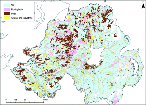
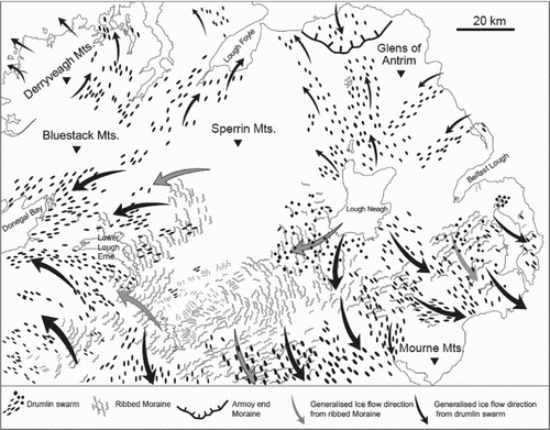
Figure 3. Map showing the distribution of ribbed moraines and drumlins in the northern half of Ireland. Generalised ice flow patterns from the last glacial cycle are marked by arrows. Note the cross-cutting relationships in the area south of Lough Neagh and around Lower Lough Erne that have been produced by different ice flow events through the last glacial cycle. In addition drumlins and the Armoy Moraine near the Glens of Antrim record ice coming onshore from southwest Scotland during the last glacial cycle. Landform orientation derived from CitationGreenwood and Clark (2008).
3. Methods
The soil samples used in the analysis were gathered during the Tellus Survey (http://www.bgs.ac.uk/gsni/tellus) undertaken in 2004–2006 by Geological Survey of Northern Ireland (GSNI) at a density of one per 2 km2 over the region and included all soil types. This amounted to a total of 6862 samples across the study area. At each locality, the samples were taken by Dutch auger from the upper soil (5–20 cm depth) following the established Geochemical Baseline Survey of the Environment (GBASE) regional soil sampling protocol (CitationJohnson, Breward, Ander, & Ault, 2005; CitationScheib et al., 2011; CitationSmyth, 2007). The soil was dried, sieved to 2 mm then homogenised in an agate ball mill before being pelletised. Soil sample geochemistry was determined via X-Ray Fluorescence (XRF) at British Geological Survey (BGS) laboratories, Keyworth. XRF provides concentration data on a suite of 52 elements, including lithophile and Rare Earth Elements.
The Tellus sample points were then draped onto the 1:250,000 Superficial Geology map of Northern Ireland (GSNI, 1991) using the Geographic Information System (GIS) ESRI ArcMap 9.3. The total study area is approximately 13,800 km2, with till comprising approximately 7400 km2 of this, non till cover totalling approximately 5345 km2 and bedrock at or close to the surface covering approximately 1055 km2. Samples that occurred on areas of non till superficial geology were rejected to leave only upper soil samples that occurred on till. This left a total of 3836 samples for analysis that displayed good spatial coverage across the study area (). The highest sample density occurs in counties Antrim, Armagh and Down with gaps in areas of non till superficial geology or areas with bedrock at or close (<1 m) to the surface.
Figure 4. Soil samples taken on areas of till superficial geology during the Tellus survey. Red triangles show the location of additional soil and till samples used in the study to calculate the Chemical Index of Alteration.
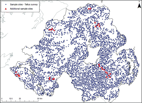
When using soil geochemistry as proxy evidence for the geochemistry of the underlying till it is important to assess the degree by which soil forming and weathering processes may have affected the bulk geochemistry through the soil profile, for example through the migration of labile elements (CitationBurek & Cubitt, 1991).To help address this, an additional 30 sites were sampled in September 2012 from across Northern Ireland (). At each location, samples of both soil and the underlying till were collected. Soil samples were taken by Dutch auger following the GBASE protocol, and a small pit was dug into the centre of the sampling area to expose the underlying till surface at the base of the soil profile. The auger was then used to sample as far down as was possible into the exposed till. At two localities a second till sample was taken from nearby exposures. The samples were then processed and analysed by XRF at BGS laboratories, Keyworth. To assess the degree of weathering at each location the Chemical Index of Alteration (CIA) was applied to the samples (CitationNesbitt & Young, 1982). This is a widely used technique that assesses the degree of weathering in rocks and regolith (CitationMcQueen & Scott, 2008; CitationNesbitt & Young, 1982) and uses the following equation:
Table 1. Chemical Index of Alteration value comparison between upper soil (A) (5–20 cm sample depth) and underlying till (T) (0.6–1.4 m depth from till surface).
Additionally a Mann–Whitney test on the elements used in the CIA calculation was performed in Minitab 16 to investigate the differences between the element medians of the till and soil samples. The Mann–Whitney test is non parametric and makes no assumption on the distribution of the data so is most appropriate for the geochemical data used in this study. The results are displayed in (Section 4.1).
Table 2. Results of the Mann–Whitney Test on the elements used for the CIA calculation for the till and soil samples. Point estimate is the hypothesised median value, W is the test statistic used to calculate the P value.
The Tellus XRF upper soil data set has a suite of 52 detected elements and Loss on Ignition (LOI) values. Of the remaining 3836 samples, those with LOI>50% were removed as organic soils, leaving a total of 3669 samples. Elements with results at or below reliable XRF detection limits were removed from the soil geochemical data. This left 28 elements for analysis (Ba, La, Ce, MgO, Al2O3, SiO2, K2O, CaO, TiO2, MnO, Fe2O3, Sc, V, Cr, Co, Ni, Cu, Zn, Ga, As, Se, Rb, Sr, Zr, Nb, Hf, Th and U). Concentration data for these elements were normalised (CitationPison, Rousseeuw, Filzmoser, & Croux, 2003) and the data imported into Minitab 16 for Principal Component Analysis (PCA).
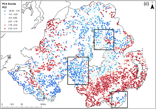
Figure 5. Comparison of single element distribution and multi element PC score distribution. PC Scores are associated with groups of elements rather than single elements. This can therefore provide more information than single element distribution alone. (a) SiO2 concentration (%) from the Tellus soil samples. Box 1 shows mid to low concentration, Box 2 high concentration and Box 3 both low and high concentrations of SiO2. (b) PC1 multi element analysis. Box 1 shows high scores associated with Ni, V, Co, Fe2O3 and 6 other elements (see results), Box 2 and 3 show low scores associated with SiO2, Rb, Th and Zr. (c). PC2 multi element analysis. Box 1 shows an area of obvious high scores associated with Ba, Ga, Ce, La, and 6 other elements (see results). The high scores are clearly oriented north west-south east (see also ). Box 2 shows low scores associated with CaO and Se. Box 3 shows high (Ba, Ga, Ce, La, etc) and low (CaO, Se) scores.
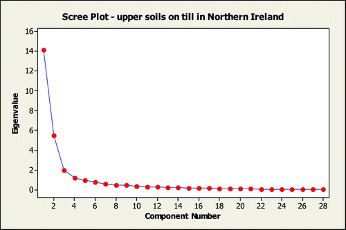
PCA was selected as the investigative method as it is a multivariate statistical technique commonly used to investigate variability in large geochemical data sets (CitationCheng, Jing, & Panahi, 2006; CitationGrunsky & Smee, 1999; CitationScheib et al., 2011). As such it can reveal more information than single element distribution (). PCA is a variable reduction method that produces a smaller number of artificial variables, called Principal Components (PCs). Each PC represents a certain amount of variability in the data and the first two PCs usually account for most of the variation within the whole data set (CitationReimann, Filzmoser, Garrett, & Dutter, 2008). When using PCA only those PCs with Eigenvalues >1 are used as they account for the majority of the variance in the data. The first four PCs have eigenvalues >1 () accounting for 81.3% of variance and are presented in the maps.
Figure 5. Continued
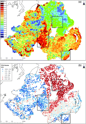
Figure 6. Scree plot of Principle Component eigenvalues for upper soil samples taken on areas of till superficial geology in Northern Ireland. A scree plot shows the eigenvalues (y-axis) of the principal components (x-axis) for the data set in descending order and indicates the relative importance of the PCs. Those PCs with eigenvalues <1 account for an increasingly small and insignificant amount of the variance in the data so are not used. In this study the first four PCs have eigenvalues >1 so are the most significant for the data set.
PCA produces eigenvectors, also referred to as principal component coefficients or loadings, describe the relative significance of a component i.e. chemical element and its variability within the data set and are used to automatically calculate scores for each PC. The element loading values determine a sample point's score, so that grouping of high loading elements give high scores and grouping of low loading elements give low scores. A sample point's score therefore reflects the element groupings. The amount of eigenvectors calculated will be equal to the numbers of variables used (CitationReimann et al., 2008), which in this study is the number of chemical elements. The PC scores were imported into the GIS to enable visualisation of the spatial distribution of the linked element groupings.
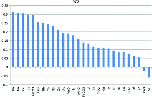
Figure 9. Element loadings for Principal Component 2.
4. Results
4.1. Chemical index of alteration
The elements used in the CIA show an overall linear realtionship in concentration values between the two sample media, indicating the till and soil have similar proportions of elements at each sample site (). Results from the CIA analysis are summarised in and clearly show there is a high degree of similarity between the geochemistry of the soil and the underlying till at each location (). This indicates strongly that weathering processes have not significantly altered the geochemistry of the soils in the study area and that soil geochemistry can be confidently used as a proxy for till geochemistry.
Figure 7. Scatterplot for percentage values of elements used in the CIA calculation. Solid grey line represents total correlation. The dashed grey line (regression) shows the linear relationship in concentration values between the two sample media, indicating similar proportions of elements.
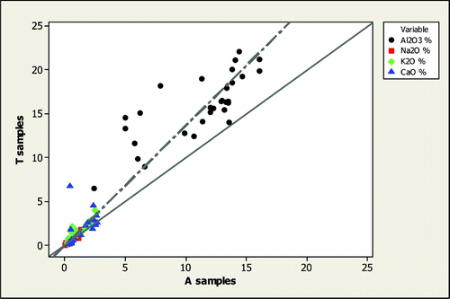
The results from the Mann–Whitney test on the elements used in the CIA calculation are presented in . The null hypothesis for this test states that there are no differences between the A and T samples. The results show the null hypothesis cannot be rejected for Na2O, K2O or CaO and support the result of the CIA by demonstrating the soil and till in the study area are geochemically similar.
4.2. Map interpretation
The maps show the PC score distribution for the four Principal Components with Eigenvalues >1. The scores are represented by a divergent colour scheme with orange to red representing increasingly positive scores and light to dark blue increasingly negative scores. Each dot represents a single sample point and individual colours equate to a score range for each PC, but as the data are not normally distributed the score ranges are not equal number increments across the four maps.
4.3. PC1
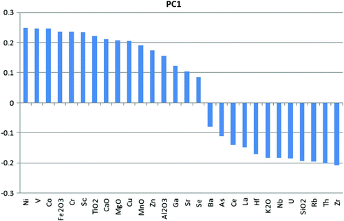
For PC1 (50.5% of variance) the highest scores equate to highest loading (>0.2) elements Ni, V, Co, Fe2O3, Cr, Sc, TiO2, CaO, MgO and Cu (). The highest scores are almost exclusively associated with Antrim Lava Group basalts (see and map) and other basic igneous bedrock areas. Lowest scores equate to the lowest loading (<−0.19) elements SiO2, Rb, Th and Zr. The map shows lowest PC1 scores on the Mourne granites with an area of low scores observed to the south side of the granite. West Fermanagh also shows a band within the lowest score bracket.
Figure 8. Element loadings for Principal Component 1.
4.4. PC2
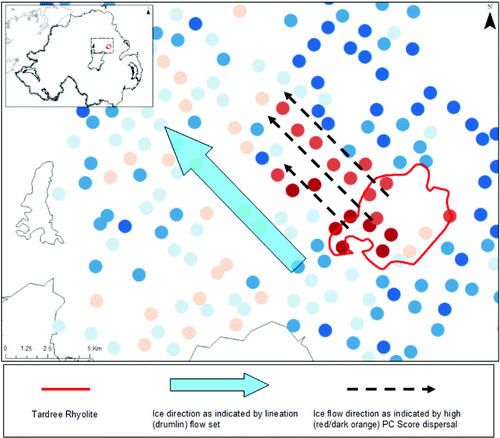
PC2 (19.5% of variance) has high scores related to strong positive loadings (>0.2) for elements Ba, Ga, Ce, La, Al2O3, K2O, Rb, Th, Nb and Zn (). The score distribution map shows high scores are mainly concentrated in areas of clay-rich sedimentary bedrock. An area of high score with a linear extension to the northwest is observed at the Tardree Rhyolite (). There is also a scatter of high scores observed in north Antrim and east Londonderry. Negative loadings and therefore low scores are recorded for CaO (−0.022) and Se (−0.058) only. The map shows a concentration of lowest scores in east and west Fermanagh.
Figure 10. PC2 Score distribution and ice flow direction. High PC2 scores are associated with the Tardree Rhyolite. High scores extending from the rhyolite outcrop in the same direction as the main glacial lineation (drumlin) flow set in the area indicate north westward dispersal of rhyolite during this flow event.
4.5. PC3
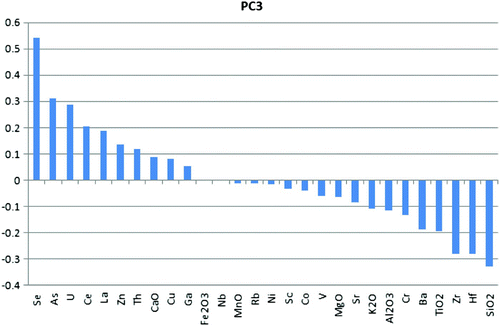
High scores for PC3 (7.1% of variance) equate to strong positive loadings (>0.2) for Se, As, U and Ce (). Concentrations of high scores are observed in south and southeast county Down, south county Armagh including the Slieve Gullion area and county Fermanagh. East and north Antrim also shows high scores on the Antrim Lava Group. The greatest negative loading (<−0.2) is for elements Zr, Hf and SiO2 and so the lowest scores on the map correlate to these elements. Low scores are observed around Lough Neagh, with a concentration of lowest scores to the southeast and an area of low scores extends south from here as far as the Newry Igneous Complex ( and map).
Figure 11. Element loadings for Principal Component 3.
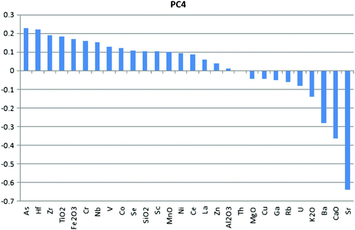
4.6. PC4
With PC4 (4.2% of variance), strong positive loadings (>0.2) are recorded for As and Hf with Zr (0.19) and TiO2 (0.183) the next highest loading (). High scores are recorded throughout the region, with concentrations in south east county Down including the Mournes, south west and east county Fermanagh and north and south Tyrone. Strong negative loadings (<−0.2) are recorded for Ba, CaO and Sr. Concentrations of the lowest scores are exclusively confined to the Newry and Slieve Gullion Igneous complexes with low scores between the Newry and Mournes igneous centres and also south of the Mournes.
Figure 12. Element loadings for Principal Component 4.
5. Conclusion
This paper presents the first geochemical maps based on analysis of soils developed on till in this sector of the BIIS. The score distribution maps for PC1 and PC2 in particular show that geochemical composition changes can occur rapidly at lithological boundaries. In PC3 and PC4 the score distribution pattern becomes less concordant with bedrock, though close associations are still observed such as the low scores of Newry Igneous Complex in PC4. Although clear transport of material is apparent, such as north west from the Tardree Rhyolite (PC2, ), or south from the Mourne Mountains (PC1), the main element associations and spatial distribution patterns derived from PCA of the Tellus soil geochemical data suggest that the majority of till deposits in Northern Ireland have been locally derived. This indicates till transport distances in this sector of the BIIS are low as different bedrock regions retain predominantly uniform PC scores. This is important because it provides new insights into how tills have been generated and transported in this sector of the BIIS which can be used to test existing ice sheet models.
Data
The data from the Tellus survey are available free for academic use from Geological Survey of Northern Ireland. Please contact [email protected] for details. The additional sample data used for the Chemical Index of Alteration calculation and Mann–Whitney test are attached to the paper as an Excel file.
Software
Microsoft Excel© was used to prepare the sample data for analysis. Minitab© 16 was used for PCA of normalised geochemical data. ESRI ArcMap 9.3 was used to prepare the main maps and map figures within the text and to select appropriate samples from the data set. Graphs were directly exported from Excel© and Minitab©.
Map design
The maps have been designed with the aim of highlighting the relationship of Principal Component score to underlying bedrock. The bedrock map was simplified to allow easier correlation between the PC Scores and regional geology. Four maps were chosen for presentation as the first four Principal Components account for the majority of variance in the data set, so show the main findings of the regional investigation.
Main Map: Principal Component Analysis on the Geochemistry of Soils Developed on Till in Northern Ireland
Download PDF (1.1 MB)Acknowledgements
We are grateful for the comments and suggestions of Dr. M.J. Smith, Dr. R.E. Roth and two anonymous reviewers that greatly enhanced the quality of this manuscript and map. The Department of Enterprise, Trade and Investment are thanked for providing funding for Tellus and additional geochemical analyses used in the paper. The research has been carried out as part of M. Dempster's DEL Phd Studentship at the University of Ulster.
Related Research Data
References
- Aario , R. and Peuraniemi , V. 1992 . Glacial dispersal of till constituents in morainic landforms of different types . Geomorphology , 6 ( 1 ) : 9 – 25 . doi: 10.1016/0169-555X(92)90044-O
- Anderson , T. B. 2004 . “ Chapter 4, Southern Uplands-Down-Longford Terrane ” . In The geology of Northern Ireland – Our natural foundation , 2 , Edited by: Mitchell , W. I. 41 – 60 . Belfast : Geological Survey of Northern Ireland .
- Boston , C. M. , Evans , D. J. A. and Ó'Cofaigh , C. 2010 . Styles of till deposition at the margin of the Last Glacial Maximum North Sea lobe of the British–Irish Ice Sheet: An assessment based on geochemical properties of glacigenic deposits in eastern England . Quaternary Science Reviews , 29 ( 23–24 ) : 3184 – 3211 . doi: 10.1016/j.quascirev.2010.05.028
- Boulton , G. S. and Clark , C. D. 1990 . The Laurentide ice sheet through the last glacial cycle: The topology of drift lineations as a key to the dynamic behaviour of former ice sheets . Transactions of the Royal Society of Edinburgh: Earth Sciences , 81 ( 4 ) : 327 – 347 . doi: 10.1017/S0263593300020836
- Boulton , G. S. , Dongelmans , P. , Punkari , M. and Broadgate , M. 2001 . Palaeoglaciology of an ice sheet through a glacial cycle: The European ice sheet through the Weichselian . Quaternary Science Reviews , 20 ( 4 ) : 591 – 625 . doi: 10.1016/S0277-3791(00)00160-8
- Broecker , W. S. 1994 . Massive Iceberg discharges as triggers for global climate change . Nature , 372 : 421 – 424 . doi: 10.1038/372421a0
- Burek , C. and Cubitt , J. M. 1991 . “ Geochemical properties of glacial deposits in the British Isles ” . In Glacial deposits in Britain and Ireland , 1 , Edited by: Ehlers , J. , Gibbard , P. L. and Rose , J. 471 – 492 . Rotterdam : A.A.Balkema .
- Cheng , Q. , Jing , L. and Panahi , A. 2006 . Principal component analysis with optimum order sample correlation coefficient for image enhancement . International Journal of Remote Sensing , 27 ( 16 ) : 3387 – 3401 . doi: 10.1080/01431160600606882
- Clark , C. D. , Knight , J. K. and Gray , J. T. 2000 . Geomorphological reconstruction of the Labrador Sector of the Laurentide Ice Sheet . Quaternary Science Reviews , 19 ( 13 ) : 1343 – 1366 . doi: 10.1016/S0277-3791(99)00098-0
- Cooper , M. R. 2004 . “ Chapter 14, Palaeogene extrusive igneous rocks ” . In The geology of Northern Ireland – Our natural foundation , 2 Edited by: Mitchell , W. I. 167 – 178 . Belfast
- Cooper , M. R. , Anderson , H. , Walsh , J. J. , van Dam , C. L. , Young , M. E. , Earls , G. and Walker , A. 2012 . Palaeogene Alpine tectonics and Icelandic plume-related magmatism and deformation in Ireland . Journal of the Geological Society, London , 169 : 29 – 36 . doi: 10.1144/0016-76492010-182
- Cooper , M. R. , Crowley , Q. G. , Hollis , S. P. , Noble , S. R. , Roberts , S. , Chew , D. M. , Merriman , R. J. , Earls , G. and Herrington , R. 2011 . Age constraints and geochemistry of the Ordovician Tyrone Igneous complex, Northern Ireland: Implications for the Grampian orogeny . Journal of the Geological Society, London , 168 : 837 – 850 . doi: 10.1144/0016-76492010-164
- Cooper , M. R. and Johnston , T. P. 2004a . “ Chapter 2, Central Highlands (Grampian) Terrane – Metamorphic Basement ” . In The geology of Northern Ireland – Our natural foundation , 2 , Edited by: Mitchell , W. I. 9 – 24 . Belfast : Geological Survey of Northern Ireland .
- Cooper , M. R. and Johnston , T. P. 2004b . “ Chapter 5, Late Palaeozoic Intrusives ” . In The geology of Northern Ireland – Our natural foundation , 2 , Edited by: Mitchell , W. I. 61 – 68 . Belfast : Geological Survey of Northern Ireland .
- Cooper , M. R. and Johnston , T. P. 2004c . “ Chapter 15, Palaeogene intrusive igneous rocks ” . In The geology of Northern Ireland – Our natural foundation , 2 , Edited by: Mitchell , W. I. 179 – 198 . Belfast : Geological Survey of Northern Ireland .
- Dempster, M.; Dunlop, P.; Cooper, M.; Scheib, A. (2013) Published map. In Dempster, M.; Dunlop, P.; Cooper, M.; Scheib, A. (2013) Principal component analysis of the geochemistry of soil developed on till in Northern Ireland.
- Dunlop , P. and Clark , C. D. 2006 . The morphological characteristics of ribbed moraine . Quaternary Science Reviews , 25 ( 13–14 ) : 1668 – 1691 . doi: 10.1016/j.quascirev.2006.01.002
- Geological Survey of Northern Ireland (GSNI). (1991). Geological Map of Northern Ireland (Quaternary), 1:250,000, Geological Survey of Northern Ireland, Belfast. ISBN 0751827630
- Geological Survey of Northern Ireland (GSNI). (1997). Geological Map of Northern Ireland (Solid), 1:250,000 , Geological Survey of Northern Ireland, Belfast. ISBN 0751831662
- Glasser, N., & Bennett, M. R. (2004). Glacial erosional landforms: origins and significance for palaeoglaciology. Progress in Physical Geography, 28(1), 43–75.
- Greenwood , S. L. and Clark , C. D. 2008 . Subglacial bedforms of the Irish ice sheet . Journal of Maps , v2008 : 332 – 357 .
- Greenwood , S. L. and Clark , C. D. 2009 . Reconstructing the Irish Ice Sheet 1: Changing flow geometries and ice flow dynamics deciphered from the glacial landform record . Quaternary Science Reviews , 28 ( 27–28 ) : 3085 – 3100 . doi: 10.1016/j.quascirev.2009.09.008
- Greenwood , S. L. and Kleman , J. 2010 . Glacial landforms of extreme size in the Keewatin sector of the Laurentide Ice Sheet . Quaternary Science Reviews , 29 ( 15–16 ) : 1894 – 1910 . doi: 10.1016/j.quascirev.2010.04.010
- Grunsky , E. C. and Smee , B. W. 1999 . The differentiation of soil types and mineralization from multi-element geochemistry using multivariate methods and digital topography . Journal of Geochemical Exploration , 67 ( 1–3 ) : 287 – 299 . doi: 10.1016/S0375-6742(99)00054-0
- Iverson, N. R. (1991). Morphology of glacial striae: implications for abrasion of glacier beds and fault surfaces. Geological Society of America Bulletin, 103, 1308–1316.
- Johnson , C. C. , Breward , N. , Ander , E. L. and Ault , L. 2005 . G-BASE: Baseline geochemical mapping of great Britain and Northern Ireland . Geochemistry: Exploration, Environment, Analysis , 5 : 347 – 357 . doi: 10.1144/1467-7873/05-070
- Kauranne , L. K. 1958 . On prospecting for molybdenum on the basis of its dispersion in glacial till . Bulletin of The Geological Society of Finland , 180 : 31 – 43 .
- Klassen, R. A. (2001). A Quaternary geological perspective on geochemical exploration in glaciated terrain. In Drift Exploration in Glaciated Terrain, Geological Society of London Special Publication 185. eds. M.B. McClenaghan, P.T. Bobrowsky, G.E.M. Hall & S.J. Cook, 1st edn, Geological Society of London, London, pp. 1–17. doi: 10.1144/GSL.SP.2001.185.01.01
- Klassen , R. A. and Thompson , F. J. 1993 . Glacial history, drift composition and mineral exploration, central labrador , Toronto : Geological Survey of Canada .
- Kleman , J. and Borgström , I. 1996 . Reconstruction of Palaeo-Ice sheets: The use of geomorphological data . Earth Surface Processes and Landforms , 21 ( 10 ) : 893 – 909 . doi: 10.1002/(SICI)1096-9837(199610)21:10<893::AID-ESP620>3.3.CO;2-L
- McCabe , A. M. and Clark , P. U. 1998 . Ice-sheet variability around the North Atlantic Ocean during the last deglaciation . Nature , 392 : 373 – 377 . doi: 10.1038/32866
- McClenaghan , M. B. , Thorleifson , L. H. and DiLabio , R. N. W. 2000 . Till geochemical and indicator mineral methods in mineral exploration . Ore Geology Reviews , 16 ( 3–4 ) : 145 – 166 . doi: 10.1016/S0169-1368(99)00028-1
- McQueen , K. G. and Scott , K. M. 2008 . “ Rock weathering and structure of regolith ” . In Regolith science , 1 , Edited by: Scott , K. M. and Pain , C. F. 105 – 126 . Collingwood , , Australia : CSIRO .
- Mitchell , W. I. 2004 . The geology of Northern Ireland – Our natural foundation , 2 , Edited by: Mitchell , W. I. Belfast : Geological Survey of Northern Ireland .
- Mitchell , W. I. 2004a . “ Chapter 6, Devonian ” . In The geology of Northern Ireland – Our natural foundation , 2 , Edited by: Mitchell , W. I. 69 – 78 . Belfast : Geological Survey of Northern Ireland .
- Mitchell , W. I. 2004b . “ Chapter 7, Carboniferous ” . In The geology of Northern Ireland – Our natural foundation , 2 , Edited by: Mitchell , W. I. 79 – 116 . Belfast : Geological Survey of Northern Ireland .
- Mitchell , W. I. 2004c . “ Chapter 10, Triassic ” . In The geology of Northern Ireland – Our natural foundation , 2 , Edited by: Mitchell , W. I. 133 – 144 . Belfast : Geological Survey of Northern Ireland .
- Mitchell , W. I. 2004d . “ Chapter 11, Jurassic ” . In The geology of Northern Ireland – Our natural foundation , 2 , Edited by: Mitchell , W. I. 145 – 148 . Belfast : Geological Survey of Northern Ireland .
- Mitchell , W. I. 2004e . “ Chapter 12, Cretaceous ” . In The geology of Northern Ireland – Our natural foundation , 2 , Edited by: Mitchell , W. I. 149 – 160 . Belfast : Geological Survey of Northern Ireland .
- Nesbitt , H. W. and Young , G. M. 1982 . Early Proterozoic climates and plate motions inferred from major element chemistry of lutites . Nature , 299 : 715 – 717 . doi: 10.1038/299715a0
- Parent , M. , Paradis , S. J. and Doiron , A. 1996 . Palimpsest glacial dispersal trains and their significance for drift prospecting . Journal of Geochemical Exploration , 56 ( 2 ) : 123 – 140 . doi: 10.1016/0375-6742(96)00011-8
- Peuraniemi , V. , Aario , R. and Pulkkinen , P. 1997 . Mineralogy and geochemistry of the clay fraction of till in northern Finland . Sedimentary Geology , 111 ( 1–4 ) : 313 – 327 . doi: 10.1016/S0037-0738(97)00023-7
- Pison , G. , Rousseeuw , P. J. , Filzmoser , P. and Croux , C. 2003 . Robust factor analysis . Journal of Multivariate Analysis , 84 ( 1 ) : 145 – 172 . doi: 10.1016/S0047-259X(02)00007-6
- Punkari , M. 1997 . Glacial and glaciofluvial deposits in the interlobate areas of the Scandinavian ice sheet . Quaternary Science Reviews , 16 ( 7 ) : 741 – 753 . doi: 10.1016/S0277-3791(97)00020-6
- Reimann , C. , Filzmoser , P. , Garrett , R. G. and Dutter , R. 2008 . Statistical data analysis explained , 1 , Chichester , , UK : John Wiley & Sons Ltd .
- Sarala , P. 2006 . Ribbed moraine stratigraphy and formation in southern Finnish Lapland . Journal of Quaternary Science , 21 ( 4 ) : 387 – 398 . doi: 10.1002/jqs.995
- Sarala , P. , Rossi , S. , Peuraniemi , V. and Ojala , V. J. 2007 . Distinguishing glacigenic deposits in southern Finnish Lapland: Implications for exploration . Applied Earth Science , 116 ( 1 ) : 22 – 36 . doi: 10.1179/174327507X167019
- Scheib , A. J. , Dunlop , P. and Cooper , M. R. 2010 . Investigating glacial sediment provenance in Northern Ireland using principal component analysis of Tellus soil geochemical data , Keyworth : British Geological Survey .
- Scheib , A. J. and Lee , J. R. 2010 . The application of regional geochemical data in defining the extent of aeolian sediments: Late Pleistocene loess and coversand deposits of East Anglia, UK . Quaternary Newsletter , 120 : 5 – 14 .
- Scheib , A. J. , Lee , J. R. , Breward , N. and Riding , J. B. Reconstructing flow paths of the middle Pleistocene British ice sheet in central-eastern England: The application of regional soil geochemical data . Proceedings of the Geologists’ Association , Vol. 122 , (3), 432–444. doi: 10.1016/j.pgeola.2011.01.008
- Smith, M. J., & Knight, J. (2011). Palaeoglaciology of the last Irish ice sheet reconstructed from striae evidence. Quaternary Science Reviews, 30(1–2), 147–160.
- Smyth, D. (2007). Methods used in the Tellus Geochemical Mapping of Northern Ireland. British Geological Survey Open Report, OR/07/022., British Geological Survey, Keyworth, England.
- Spagnolo , M. , Clark , C. D. , Hughes , A. L. C. , Dunlop , P. and Stokes , C. R. 2010 . The planar shape of drumlins . Sedimentary Geology , 232 ( 3–4 ) : 119 – 129 . doi: 10.1016/j.sedgeo.2010.01.008
- Veillette , J. J. 2004 . Ice flow chronology and palimpsest; long distance dispersal of indicator clasts north of the St. Lawrence River valley, Quebec . Geographie physique et Quaternaire , 58 ( 2–3 ) : 187 – 216 . doi: 10.7202/013138ar