Abstract
This work presents the Morphotectonic map of the Aventino-Lower Sangro valley, located in the southern Abruzzi area, and extending from the Apennines chain to the eastern piedmont, from the Maiella Mountain to the Adriatic coast. It is the result of an extensive drainage basin scale geomorphological analysis carried out in the Abruzzi area and incorporates four main sections: orography and hydrography (upper right on the map); morphotectonic section (centre and left on the map); quaternary fluvial deposits and terraces section (right on the map) and the long morphotectonic profile (lower right on the map).
The map presented in this work provides a basis for the recognition of morphotectonic features at basin scale, the detection of tectonic control on landscape, and the reconstruction of paleo-landscapes. It contributes to defining the main phases of the post-orogenic landscape evolution of the transition zone between the Apennines chain and the eastern piedmont area, resulting from the combination of alternating morphotectonics and surface processes, due to rock uplift processes, local tectonics and slope and fluvial processes.
1. Introduction
An extensive drainage basin scale geomorphological analysis in the Apennines chain and Adriatic piedmont of the Central Apennines (Italy) enabled the creation of morphotectonic maps (see also CitationMiccadei, Orrù, Piacentini, Mascioli, & Puliga, 2012). In this case, we are presenting the Morphotectonic map of the Aventino-Lower Sangro valley (Abruzzo, Italy) (Scale 1:50.000) implemented within a geographic information system (GIS) by means of: digital elevation model (DEM) and map-based cartographic analysis and morphometry of orography and hydrography (raster and vector data scale 1:25,000–1:10,000, 5 m grid DEM), photogeological analysis (scale 1:33,000), Quaternary continental deposits, fluvial terraces and structural geomorphological field mapping (scale 1:10,000), morphotectonic profiles that couple landform, deposits and terraces.
The Morphotectonic map of the Aventino-Lower Sangro valley (Abruzzo, Italy) incorporates four main sections:
| 1. | orography and hydrography (upper right on the map); | ||||
| 2. | morphotectonic map (centre and left on the map); | ||||
| 3. | quaternary fluvial deposits and terraces (right on the map); | ||||
| 4. | long morphotectonic profile (lower right on the map). | ||||
2. The study area
The Aventino-Lower Sangro valley is located in the transition zone between the central Apennines chain front (Maiella, Porrara Mts) and the Adriatic coast, crossing the whole Apennines piedmont, in the south eastern Abruzzi area (,b and ). The valley, sloping from SW to NE, from >500 m a.s.l. to sea level, lies in a complex geological and geomorphological framework characterized mostly by fault homocline ridges, thrust ridges and anticline ridges in the chain area, by isolated reliefs, hogback and cuesta reliefs in the western highest piedmont, and by a mesa and plateau relief in the lowest eastern piedmont. The piedmont ends with a cliffed coast broken by the wide alluvial valleys of the main rivers (such as the Sangro river) and by the small and sharp valleys of the minor rivers.
Figure 1. (a) Location map of the Aventino and lower Sangro valley. (b) Location of the Aventino and lower Sangro valley within the chain, piedmont and hilly coastal area of the Abruzzo region (3D view from south, 90 m DEM, NASA-SRTM).
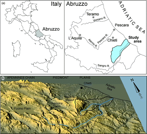
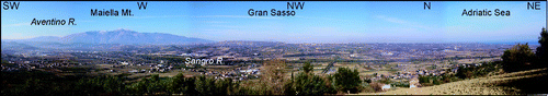
Figure 2. Panoramic view of the Aventino and lower Sangro valley.
The Central Apennines are an asymmetric mountain range characterized by alternating ridges (up to 2900 m high; Gran Sasso, 2912 m; Maiella, 2793 m) and valleys with a NW-SE to N-S orientation, as well as by wide intermontane basins (i.e. Fucino Plain, Sulmona Basin). It is a thrust belt migrated north-east, that built up during the Neogene (CitationCalamita, Esestime, Paltrinieri, Scisciani, & Tavarnelli, 2009; CitationCarminati & Doglioni, 2004; CitationParotto & Praturlon, 2004; CitationPatacca & Scandone, 2007). Since the Late Pliocene the Apennines have been affected by differential uplift and extensional tectonics with the emergence of the Apennine piedmont and the formation of intermontane basins (CitationAscione, Cinque, Miccadei, Villani, & Berti, 2008; CitationCavinato & De Celles, 1999; CitationD'Agostino, Jackson, Dramis, & Funiciello, 2001; CitationD'Alessandro, Miccadei, & Piacentini, 2003).
An abrupt morphologic boundary separates the chain area from the Adriatic piedmont, which shows cuestas, mesas and plateaux landscapes, that slope from approximately 1000 m a.s.l. along the chain front (Maiella massif) to <100 m close to the coast. Here the main rivers flow along wide floodplains, generally in a SW-NE direction. In the piedmont area, Middle Pliocene to Early Pleistocene late-orogenic clayey-sandy marine sediments of the Adriatic basin unconformably overlie sin-orogenic foredeep arenaceous and pelitic Miocene–Early Pliocene sequences and thrusts or anticlines on pre-orogenic clayey and carbonate pelagic sequences (see lithological box in the map) (CitationCalamita, Satolli, Scisciani, Esestime, & Pace, 2011; CitationCrescenti, Milia, & Rusciadelli, 2004; CitationOri, Roveri, & Vannoni, 1986). In the lower Pleistocene a sandy and conglomeratic sequence records a regressive phase with a gradual transition from a marine environment to a beach and, subsequently, a continental one (CitationCantalamessa & Di Celma, 2004). The present structural setting is characterized by a wide homocline gently dipping north-east, affected by fractures and low displacement faults, as a response to Pleistocene uplift and local tectonics which induced fluvial and slope processes (CitationD'Alessandro et al., 2008; CitationDella Seta et al., 2008).
A sequence of post-orogenic Quaternary continental deposits has formed, mainly consisting of slope, alluvial fan and fluvial deposits arranged in a series of terraces. The alluvial fans developed on the transition zone between chain and piedmont immediately after emergence, during the Middle Pleistocene. The fluvial deposits are set in a sequence of four main levels of terraces. In the most relevant literature concerning the Adriatic piedmont, the age of the fluvial deposits is correlated with climatic fluctuations (CitationD'Alessandro et al., 2008; CitationDemangeot, 1965; CitationISPRA, 2010). The highest terrace is ascribed to the Middle Pleistocene, the second terrace to the late Middle Pleistocene, the third one is dated to the Late Pleistocene, and the fourth to the Holocene (CitationColtorti, Consoli, Dramis, Gentili, & Pambianchi, 1991; CitationDi Celma, Farabollini, & Moscatelli, 2000; CitationFarabollini, 1999; CitationNesci, Savelli, Calderoni, Elmi, & Veneri, 1995).
The Aventino-Lower Sangro valley is located in the southeastern part of the Abruzzo region. It is bordered by the Aterno Pescara river basin (in the Maiella area) and by minor basins (Moro River basin in the piedmont area) to the north, by endoreic areas (in the chain area) to the west, by the Osento River and Sinello River basins to the south.
The Sangro river is currently 107 km long and flows on the Adriatic side of central Italy, from the inner part of the Apennines to the coast where the lower reach flows from SW to NE. The Aventino river is the main tributary, which flows SW-NE along the eastern side of the Maiella massif and then turns WNW-ESE into the Sangro 20 km away from the coast ().
3. Methods
A drainage basin scale geomorphological analysis enabled the creation of the Morphotectonic map of the Aventino-Lower Sangro valley presented in this work, by means of: cartographic analysis and morphometry of orography and hydrography (raster and vector data scale 1:25,000–1:10,000; 5 m DEM), photogeological analysis (scale 1:33,000), Quaternary continental deposits and structural geomorphological field mapping (scale 1:10,000) and morphotectonic profiles ().
Figure 3. Methods for the creation of the Morphotectonic map of the Aventino and lower Sangro valley.
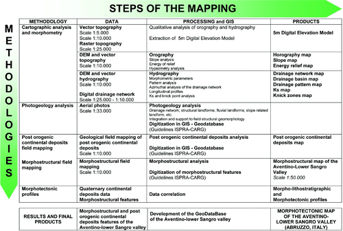
From the 1:5,000 scale vector map a DEM (5 m cell) was extracted, on which orography analysis is based. Slope analysis, local relief analysis (sensu CitationAhnert, 1984, elevation range on a 1 km2 window) and hypsometry, Ks (steepness index) and knick-points analysis (CitationBurbank & Anderson, 2011; CitationCiccacci, D'Alessandro, Fredi, & Lupia Palmieri, 1992; Strahler, Citation1952; CitationWobus et al., 2006; and reference therein) were carried out.
Hydrographic analysis is based on the 5 m DEM and 1:25,000 scale topographic map. Stream profiles, drainage density, azimuth of the drainage network, stream patterns and hydrographic parameters were analyzed (bifurcation parameters, hierarchic parameters, areal parameters, etc.; CitationAvena, Giuliano, & Lupia Palmieri, 1967; CitationBurbank & Anderson, 2011; CitationCiccacci et al., 1992; CitationCiccacci, Fredi, Lupia Palmieri, & Salvini, 1986; CitationHack, 1973; CitationHorton, 1932, Citation1945; CitationKeller & Printer, 2001; CitationMiller, 1953; CitationSchumm, 1956; CitationStrahler, 1957; CitationWobus et al., 2006 and reference therein).
Photogeological analysis was performed for the Aventino-Lower Sangro valley using 1:33,000 scale aerial photos and on 1:10,000 orthophoto color images, for preliminarily mapping of the main landforms (tectonic and structural landforms, fluvial landforms, slope landforms, etc.).
Structural geomorphology field mapping (scale 1:10,000) was carried out investigating bedrock, Quaternary continental deposits, the main tectonic elements and morphotectonic elements the main tectonic and morphotectonic elements (ridges, slopes, valleys, hydrographic forms and fluvial terraces) (CitationAmbrosetti et al., 1987; CitationBigi et al., 1996; CitationBurbank & Anderson, 2011; CitationCapolongo, Cecaro, Giano, Lazzari, & Schiattarella, 2005; CitationCentamore, Ciccacci, Del Monte, Fredi, & Lupia Palmieri, 1996; CitationCiccacci, D'Alessandro, Dramis, & Miccadei, 1999; CitationCiccacci et al., 1986; CitationD'Alessandro et al., 2008; CitationENEL, 1981; CitationGriffiths, Smith, & Paron, 2011; CitationKeller & Printer, 2001; Lupia Palmieri et al., 1996; CitationMiccadei, Mascioli, & Piacentini, 2011; CitationMiccadei et al., 2012; CitationMiccadei, Paron, & Piacentini, 2004; CitationMolin, Pazzaglia, & Dramis, 2004; CitationOtto, Gustavsson, & Geilhausen, 2011; CitationPazzaglia, 2013; CitationPanizza & Castaldini, 1987; CitationPicotti, Ponza, & Pazzaglia, 2009).
Field mapping integrated with photogeological analysis led to the creation of: (1) main morphotectonic map, (2) Quaternary fluvial deposits and terraces map, (3) morpho-lithostratigraphic profiles and (4) morphotectonic profiles.
4. Results
The main features of the Aventino-Lower Sangro valley are presented in the morphotectonic map (scale 1:50,000), which incorporates four main sections, described in the following paragraphs:
4.1. Orography and hydrography section
The Aventino-Lower Sangro valley reaches its maximum altitude in the western sector, at Monte Amaro, 2793 m a.s.l. (Maiella) and to the east the topography slopes down with abrupt changes to the Aventino-Sangro junction and to the Sangro mouth into the Adriatic Sea. Three main orographic sectors can be identified in the study area:
Sector (1) a western high mountain sector, including the eastern slope of the Maiella massif, from <500 m in the lower part to 2793 m a.s.l. in the upper part and slopes up to >200% with several vertical scarps; the energy relief ranges from between 200 m and >1000 m.
Sector (2) a SW low mountain sector, with elevations from 300–400 m to >1300 m and slopes from ∼50% to more than 100% and some local vertical scarps; the energy relief ranges from 100 m to >300 m.
Sector (3) a NE hilly area mostly with tabular relief, at an elevation ≤600 m a.s.l. and slopes usually ≤50% but with some local high slope to vertical scarps along the edge of the tabular relief and along the coastal cliffs that border this area to the NE; the energy relief ranges from 0 to >200 m.
The whole area is divided into 44 subcatchments with outlets at the junction of the main rivers or at the sea mouth. The sizes vary from <1 km2 to 52.5 km2 with interfluve areas of ∼64 km2, between the outlets. For each catchment the drainage pattern is defined (see boxes in upper part of the map), as well as the azimuth distribution of the drainage lines ( ), and the main hypsometric parameters ( and ):
Figure 4. Drainage lines azimuth distribution for each drainage sub basin (number 1–42); sub basins 43 and 44 have no diagrams being respectively a small endoreic area (43) and the interfluve area between the sub basins, along the main river.
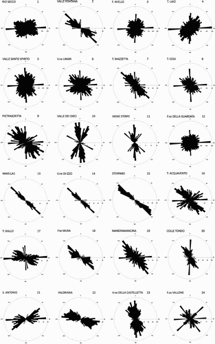
Figure 4. (Continued)
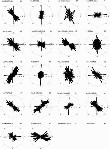
Figure 5. Hypsometry map of the study area (numbers refer to the drainage sub basins).
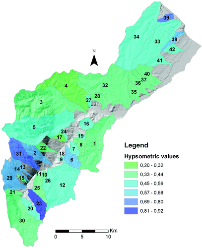
Figure 6. Hypsometry diagram for each drainage sub basin (number 1–42); sub basins 43 and 44 have no diagrams being respectively a small endoreic area (43) and the interfluve area between the sub basins, along the main river.
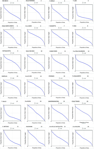
Figure 6. (Continued)
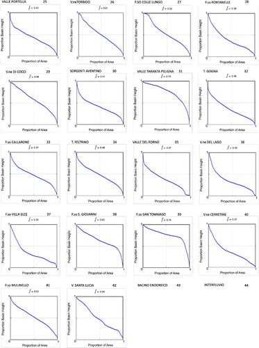
Sector (1) shows subparallel patterns in the SW part along the minor incision on the Maiella flank and subdendritic to trellis patterns in the NE part along the main and deep valleys carved on the Maiella flank; the azimuth of the drainage lines are mostly from NW-SE to WNW-ESE and locally SW-NE or W-E; the values of the hypsometric integral are from high to very high (0.45–0.92) except for the NE catchment (0.37), while the hypsometric diagrams show mostly from markedly convex to rectilinear curves, and locally concave convex; the ksn (normalized steepness index) values are always from high to very high, with knick zones mostly between 900 m and 1500 m.
Sector (2) shows a more articulate distribution of drainage patterns, with mostly subdendritic patterns and two main basins showing contorted patterns (in the SW part) and pinnate passing to trellis pattern (in the NE part); local pinnate and angular patterns are present; the azimuth of the drainage lines is variable from NW-SE to N-S and locally SW-NE or E-W; the hypsometric integrals are highly variable too, ranging from 0.33 to 0.68, with diagram shape slightly concave convex or rectilinear; the ksn values are highly variable in this sector, form very low to moderately high, with several knick zones scattered between 200 and 250 m to >900 m.
Sector (3) is again homogeneous, with pinnate to trellis patterns in the SW catchments and parallel or subparallel patterns in the NE ones; the azimuth of the drainage lines is mostly SW-NE with spikes in E-W or N-S directions and some basins with NW-SE prevailing azimuth of the drainage lines; the hypsometric integrals show low values in the SW part (0.20–0.32) and moderately high values in the NE part (mostly 0.45–0.56, with higher values in a few minor catchments), with diagram shape markedly concave convex; the ksn values are always low in this sector, with knick zones at elevations between 10 m and 300 m; only the boundary area between sector 2 and 3 shows moderately high to high values of ksn.
4.2. Morphotectonic Map
In the morphotectonic map, lithology and morphotectonic elements are mapped.
Outcropping lithologies are classified by the general geodynamic context of formation, according to the recent official national geological mapping (CitationISPRA, 2012). The lithology units are listed in the following paragraphs, from the oldest to the newest (the numbers refer to the map).
4.2.1 Pre-orogenic marine deposits (18)
Pre-orogenic marine deposits are mapped in a single unit which include different kinds of rocks pertaining to two main successions: the Meso-Cenozoic Molise basin succession in the SE mountain area made up of few tens of meters of limestone and marly limestone levels topping marly pelagic succession and chaotic clay assemblages (Sector 2; Lower Cretaceous to Lower Miocene age; CitationPatacca & Scandone, 2007; CitationSGI, 1970, Citation1971; CitationVezzani, Ghisetti, & Festa, 2004) and the Meso-Cenozoic Maiella carbonate platform succession in the NW mountain area made up of a thick sequence of well-stratified limestone carbonate platform facies (Sector 1; Lower Cretaceous to Lower Miocene age; CitationPatacca & Scandone, 2007; CitationSGI, 1970, Citation1971; CitationVecsei, Sanders, Bernoulli, Eberli, & Pignatti, 1998).
4.2.2 Sin-late orogenic marine deposits (17)
These deposits are mapped in a single unit which include different kinds of sedimentary sequences unconformably overlying pre-orogenic marine deposits. This unit includes: few tens of meters of conglomerates and calcarenites piggy-back basin successions; few tens of meters of evaporites succession; a thick pelitic-arenaceous turbiditic succession; a thin calcarenites and calcirudites turbiditic succession. This unit is of Upper Miocene–Lower Pliocene age (CitationPatacca & Scandone, 2007; CitationSGI, 1970, Citation1971; CitationVezzani et al., 2004).
4.2.3 Late-post-orogenic marine deposits (16)
One unit is mapped, including a several hundreds meter thick regressive neritic sequence of clay, sand and conglomerate, pertaining to the Plio-Pleistocene marine succession of the Adriatic basin and to the Formazione di Mutignano. The unit is of Upper Pliocene–Lower Pleistocene age (CitationISPRA, 2012; CitationMiccadei et al., 2012).
4.2.4 Post-orogenic continental deposits (from 15 to 1)
These deposits are listed below and grouped in to three main classes ( and ). The description of the deposits is reported in the legend of the map. The age given by regional correlation to geochronological dating (CitationD'Alessandro et al., 2008) but also supported by paleosols and lithic industries (see the diagram of Quaternary continental deposits on the map).
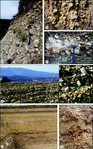
Figure 7. Post-orogenic continental deposits of the Aventino valley. (a) Palena and Lettopalena breccias; (b) Pennapiedimonte breccias; (c) Maiella breccias; (d) Piano Laroma conglomerates; (e) Southern Maiella breccias; (f) Piano La Fara conglomerates.
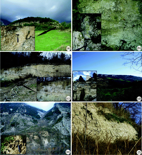
Figure 8. Post-orogenic continental deposits of the lower Sangro valley. (a) Heterometric, poorly sorted, cobble to boulder conglomerate deposits of Lucianetti gravel; (b) moderately sorted, pebble to cobble conglomerate deposits pertaining to San Giovanni in Venere conglomerates; (c) well-rounded, moderately sorted conglomerates pertaining to Piano della Madonna conglomerates; (d) gravel lag related to Piano della Madonna conglomerates (box: a close-up of the gravel deposits); (e) gravel and sand deposits (lower part), overlain by sand deposits with brown silt levels, related to Piano La Fara conlomerates; (f) conglomerates with sandy lenses (close up of ).
Pleistocene deposit of the Aventino river valley:
| • | Palena and Lettopalena breccias (15) Middle Pleistocene | ||||
| • | Pennapiedimonte breccias (14) Middle Pleistocene | ||||
| • | Piana d'Ascigno gravels (13) Middle Pleistocene | ||||
| • | Piano Laroma conglomerates (12) Late Middle Pleistocene | ||||
| • | Colle San Marco gravels (11) Late Middle Pleistocene | ||||
| • | Maiella breccias (10) Late Middle Pleistocene | ||||
| • | Piano La Fara conglomerates (5b) Upper Pleistocene | ||||
| • | Southeastern Maiella breccias (9) Upper Pleistocene | ||||
| • | Lucianetti gravels (8) Middle Pleistocene | ||||
| • | San Giovanni in Venere conglomerates (7) Late Middle Pleistocene | ||||
| • | Piano della Madonna conglomerates (6) Upper Pleistocene | ||||
| • | Piano La Fara conglomerates (5a) Upper Pleistocene | ||||
| • | Lacustrine silts (4) | ||||
| • | Fluvial deposits (3) | ||||
| • | Landslide deposits (2) | ||||
| • | Scree slope deposits and moraine deposits (1) | ||||
4.2.5 Morphotectonic elements
Morphotectonic elements are classified as Ridges, Slopes, Valleys and Hydrography (). Type, location, orientation and nature of the mapped landforms are related to the three main orographic sectors as described in the following paragraphs.
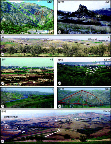
Figure 9. Morphotectonic elements in the Aventino and lower Sangro valley. (a) Wine-glass valley and flat-iron in the eastern flank of the Maiella ridge. (b) Hog-back in the SE side of the aventino valley (Roccascalegna village). (c) Linear valleys (black lines) incising alluvial fan surfaces (north of the Sangro valley). (d) NW side of the Sangro River valley: beheaded valley on the drainage divide and NNW–SSE linear valley cutting fluvial terraces. (e) Lower Sangro River valley: alignment of a linear valley and a beheaded valley. (f) NE side of Aventino River valley: a river bend. (g) NW tributary of the Aventino River: NNW-SSE triangular facets. (h) NW side of the Sangro River valley: NNW–SSE and WSW–ENE linear valleys (black lines), river bends (white lines) and WSW–ENE counterflow confluences of streams (white arrows).
Sector 1 (Maiella mountain area). This sector is characterized by three main valleys (in the northern part), deeply incised in the pre-orogenic carbonate succession. These valleys show mostly SW-NE and NW-SE orientation (only one is WSW-ENE); they are locally U-shaped in the upper part (due to their glacial origin) and sharply V-shaped in the lower part, with deep gorges, at the boundary with sector 2; this results in an overall wine glass shape to the valleys. The streams show sharp single and double bends and several hanging valleys (corresponding to the main knick points outlined by the oro-hydrographic investigations).
The slopes of the valleys are characterized by sharp vertical rock scarps and step-like slopes strictly related to the lithostructural control of the thick layers in the carbonate succession.
On the interfluves sharp SW-NE and NW-SE ridges are present, both symmetrical and asymmetrical, with several planar and altimetric discontinuities. In the highest part of the flank, glacial cirques are present.
The southern part of the Maiella flank is remarkably different as regards morphotectonic elements. The slope is characterized by narrow straight incisions (V-shape and U-shape) and several hanging valleys. The wide planar interfluves are due to the main structural surfaces.
The bottom of the Maiella flank, at the boundary between sector 1 and 2, is characterized by flat-irons (due to the calcareous strata attitude parallel to the main flank), sharp bends and alluvial fans (mostly inactive and terraced).
Sector 2 (SW low mountain area). This sector shows a scattered heterogenous distribution of morphotectonic features. The main features are ridges (symmetrical and asymmetrical), cuestas and hogbacks, saddles, structural scarps and triangular facets (mostly in NNE-SSW and WNW-ESE directions), related to the outcropping of thin calcareous levels of the pre-orogenic succession or conglomerates-arenaceous levels of the sin-orogenic succession. These features also control fluvial river bends, hanging valleys, 90° confluence, centrifugal drainage, etc.
The features and their related distribution show a strong lithostructural control which is also related to widespread landslides which are present (affecting the marly-clayey pre-orogenic successions).
Sector 3 (piedmont-coastal area). The NE sector of the study area is characterized by a wide structural surface that developed at the top of the late-post-orogenic marine succession. This surface is well preserved in the NE part and it is deeply incised by SW-NE rectilinear and entrenched fluvial segments edged by sharp structural scarps. River bends join fluvial segments mostly along a WSW-ENE and NNE-SSW direction. Several hanging valleys break the continuity of the long profile of the valleys, as already shown by the orographic and hydrographic analysis. Along the flank of the Sangro valley, four main river terraces are present.
Toward SW a series of N-S to NNE-SSW beheaded valleys divides Sector 3 into two parts.
The SW part is characterized by more areal erosion features, mostly along the NNW-SSE to NW-SE directions, perpendicular to the NE part, and secondarily along SW-NE direction. The main features are: rectilinear fluvial segments, river bends, 90° confluences, major gullies and badlands, hanging valleys (along the valleys); several saddles (on the ridges) together with some fluvial terraces scarps edging small remnants of fluvial and alluvial fan deposits. Along the NE slopes of the main NW-SE fluvial segments, systems of aligned triangular facets are present, particularly at the boundary between Sector 3 and Sector 1 and 2.
4.3. Quaternary continental deposits section
A specific section is devoted to Quaternary fluvial, alluvial fan and slope deposits, already mapped in the morphotectonic map, and their correlation to fluvial erosion scarps, which enables the definition of fluvial terraces and the outline of possible age (also according to CitationD'Alessandro et al., 2008) and UBSU (Unconformity-Bounded Stratigraphic Units, International Subcommission on Stratigraphic Classification, ISCC, CitationSalvador, 1994).
While recent eluvial, colluvial, fluvial and landslide deposits almost completely cover the slopes of the main valleys, ancient (Middle to Upper Pleistocene) fluvial deposits partly fill the bottom of the main and secondary valleys (Sector 2 and 3); alluvial fan and slope deposits are scattered mostly on the eastern slopes of the Maiella mountain (Sector 1) and in its near piedmont (boundary between Sector 1 and Sector 2 and 3). Fluvial, alluvial fan and slope deposits are at different elevations above sea level and at different heights above the present Aventino and Sangro channels. The correlation of the deposits from the youngest to the oldest, by means of morpho-lithostratigraphic transverse profiles, is based on a height above the present channel and on the physical continuity of deposits and fluvial erosion scarps (see boxes in central part of the map).
Local correlation, chronological constraints (a well-developed paleosol and a lithic industries site) and correlation with the neighboring valleys (i.e. CitationISPRA, 2010; Sangro, Pescara, Tronto, Salinello, CitationD'Alessandro et al., 2008) allows us to outline at least four possible Pleistocene UBSU (plus the Holocene deposits) and infer their ages, which are: Middle Pleistocene, late Middle Pleistocene, Upper Pleistocene, late Upper Pleistocene, respectively.
4.4. The morphotectonic profile section
In the morphotectonic profiles, morphotectonic elements (slopes, ridges, valleys, hydrography) are correlated to continental deposits and to knick point location and Ks values summarizing all collected data and outlining the distribution of processes affecting the area (mainly slope and gravity processes and fluvial processes connected to the hydrography).
Below these, topographic continental deposits are drawn. Morphotectonic elements are drawn according to their location and orientation along the profile (with the actual cross angle to the profile). The location of knick points and the distribution of Ks is shown in the upper part. Process distribution is shown at the top. The profiles have different horizontal and vertical scales for review of graphical and visual balance.
5. Conclusion
The morphotectonic investigations presented in this work provide a contribution to the definition of the role of selective erosion and tectonics in landscape evolution and their related timings, particularly in areas such as the Aventino – lower Sangro valley, with a complex geological setting–different types of succession and lithologies outcropping–and recent evolution–post Early Pleistocene in the whole NE sector–(see also CitationBahrami, 2012; CitationCentamore et al., 1996; CitationCiccacci et al., 1986; CitationD'Alessandro et al., 2003, Citation2008; CitationDella Seta et al., 2008; CitationDel Monte, Di Bucci, & Trigari, 1996; CitationFigueroa & Knott, 2010; CitationGioia, Schiattarella, Mattei, & Nico, 2011; CitationGoldsworthy & Jackson, 2000; CitationMiccadei et al., 2004; CitationMiccadei et al., 2011; CitationMolin et al., 2004; CitationNesci et al., 1995; CitationPazzaglia, 2013; CitationWegmann & Pazzaglia, 2009).
According to the geologic and morphotectonic features, the study area can be divided into three main sectors:
Sector 1 – Maiella mountain area; | |||||
Sector 2 – SW low mountain area; | |||||
Sector 3 – NE piedmont-coastal area. | |||||
The landscape of Sector 2 is characterized by isolated calcareous relief and ridges on gentle marly-clayey slopes. The drainage shows irregular patterns with patches of centrifugal ones and several 90° and counterflow confluences; the valley long profiles are irregular and knick-pointed, with several hanging valleys. The relief is characterized by sharp ridges, hogback and cuestas. These features are mostly due to selective erosion of thin calcareous levels in a marly-clayey succession, again induced by base level lowering in the main river.
Sector 3 shows a cuesta and plateaux landscape gently dipping NE, incised by small rectilinear and entrenched fluvial segments and by main cataclinal valleys, such as the Sangro valley. The valleys show two main perpendicular orientations–SW-NE in the NE part toward the coastal area and NW-SE to NNW-SSE in the SE part, toward the boundary with Sector 1 and 2; the beheaded valleys (in the central part) outline an abrupt drainage rearrangement of the Aventino drainage from SW-NE toward the coast and WNW-ESE toward the Sangro river. These features are again connected to sea level fluctuations, but are strictly controlled by NW-SE to NNW-SSE tectonic elements affecting mostly the area at the boundary between Sector 1 and 2 and Sector 3.
This area is very important in the Aventino and lower Sangro valley, likely being controlled by the NNW-SSE tectonic element and possibly by well-known deep buried tectonic structures, that induced the fluvial capture of the Aventino river, previously flowing NE into the Adriatic sea–as outlined also by remnants of fluvial deposits–and now flowing SE into the Sangro river.
This map enables the recognition of morphotectonic features at a basin scale, the detection of tectonic controls on landscape, and the reconstruction of paleo-landscapes, contributing to the definition of the main phases of post-orogenic landscape evolution of the chain front and piedmont area of the Apennines chain. This results from the link between alternating morphotectonics and surface processes (selective erosion controlled by lithostructural setting), due to rock uplift processes, local tectonics and alternating slope, fluvial and (at high elevation) glacial processes.
Software
The map presented in this work has been produced in two phases, carried out using different software applications. In the first phase, vector and raster data and the main map were managed in the Esri ArcGIS 9.3. In the second phase, the final editing was managed with Corel Draw.
Main Map: Morphotectonic Map of the Aventino-Lower Sangro Valley (Abruzzo, Italy)
Download PDF (18.3 MB)Acknowledgements
The authors wish to thank the Struttura Speciale di Supporto Sistema Informativo Regionale of Abruzzo Region (http://www.regione.abruzzo.it/xcartografia/) for providing the topographic data and aerial photos used for the geomorphological investigations and for the morphotectonic map. The authors wish to thank also the reviewers, Jean-Daniel Champagnac, Igor Florinsky and John Abraham, for comment and suggestions, which greatly improved the manuscript and the map. Secondary authors contributed to field mapping (Adriano Dal Pozzo, Marco La Corte) and cartography (Marco Sciarra).
The work was supported by University ‘G. d'Annunzio’ of Chieti Pescara funds (E. Miccadei and T. Piacentini).
Related Research Data
References
- Ahnert , F. 1984 . Local relief and height limits of mountain ranges . American Journal of Science , 284 : 1035 – 1055 .
- Ambrosetti , P. , Bartolini , C. , Bosi , C. , Carraio , F. , Ciaranfi , N. , Panizza , M. , Papani , G. , Vezzani , L. and Zanferrari , A. 1987 . Neotectonic map of Italy (Scale 1:500.000) . C.N.R., P. F. Geodinamica., Monografia finale, 4, 6 maps ,
- Ascione , A. , Cinque , A. , Miccadei , E. , Villani , F. and Berti , C. 2008 . The plio-quaternary uplift of the apennine chain: New data from the analysis of topography and river valleys in central Italy . Geomorphology , 102 : 105 – 118 .
- Avena , G. C. , Giuliano , G. and Lupia Palmieri , E. 1967 . Sulla valutazione quantitativa della gerarchizzazione ed evoluzione dei reticoli fluviali . Bollettino della Società Geologica Italiana , 86 : 781 – 196 .
- Bahrami , S. 2012 . Morphotectonic evolution of triangular facets and wine-glass valleys in the Noakoh anticline, Zagros, Iran: Implications for active tectonics . Geomorphology , 159–160 : 37 – 49 . doi: 10.1016/j.geomorph.2012.03.003
- Bigi , S. , Cantalamessa , G. , Centamore , E. , Didaskalou , P. , Dramis , F. , Farabollini , P. , Gentili , B. , Invernizzi , C. , Micarelli , A. , Nisio , S. , Pambianchi , G. and Potetti , M. 1996 . La fascia periadriatica marchigiano – abruzzese dal Pliocene medio ai tempi attuali . Evoluzione tettonico – sedimentaria e geomorfologica. Studi Geologici Camerti , 1995/1 : 37 – 49 .
- Burbank , D. W. and Anderson , R. S. 2011 . Tectonic geomorphology , 2 , Chester, West Sussex, UK : Wiley-Blackwell .
- Calamita , F. , Esestime , P. , Paltrinieri , W. , Scisciani , V. and Tavarnelli , E. 2009 . Structural inheritance of pre- and synorogenic normal faults on the arcuate geometry of pliocene–quaternary thrusts: Examples from the central and southern apennine chain . Italian Journal of Geosciences , 128 ( 2 ) : 381 – 394 . doi: 10.3301/IJG.2009.128.2.381
- Calamita , F. , Satolli , S. , Scisciani , V. , Esestime , P. and Pace , P. 2011 . Contrasting styles of fault reactivation in curved orogenic belts: Examples from the central apennines (Italy) . Geological Society of America Bulletin , 123 ( 5/6 ) : 1097 – 1111 . doi: 10.1130/B30276.1
- Cantalamessa , G. and Di Celma , C. 2004 . Sequence response to syndepositional regional uplift: Insights fromhigh-resolution sequence stratigraphy of the late early pleistocene strata, Periadriatic Basin, central Italy . Sedimentary Geology , 164 : 283 – 309 . doi: 10.1016/j.sedgeo.2003.11.003
- Capolongo , D. , Cecaro , G. , Giano , S. I. , Lazzari , M. and Schiattarella , M. 2005 . Structural control on drainage network of the south-western side of the agri river upper valley (Southern Apennines, Italy) . Geografia Fisica e Dinamica Quaternaria , 28 ( 2 ) : 169 – 180 .
- Carminati , E. and Doglioni , C. 2004 . “ Europe–Mediterranean tectonics ” . In Encyclopedia of geology , Edited by: Selley , R. C. , Cocks , L. R. M. and Plimer , I. R. 135 – 146 . Elsevier .
- Cavinato , G. P. and De Celles , P. G. 1999 . Extensional basins in the tectonicallybiomodal central Appennines fold-thrust belt, Italy: Response tocorner flow above a subduction slab in retrograde motion . Geology , 27 : 956 – 959 . doi: 10.1130/0091-7613(1999)
- Centamore , E. , Ciccacci , S. , Del Monte , M. , Fredi , P. and Lupia Palmieri , E. 1996 . Morphological and morphometrical approach to the study of structural arrangement of the northeastern Abruzzo (Central Italy) . Geomorphology , 16 : 127 – 137 . doi: 10.1016/0169-555X(95)00138-U
- Ciccacci , S. , D'Alessandro , L. , Dramis , F. and Miccadei , E. 1999 . Geomorphologic evolution and neotectonics of the sulmona intramontane basin (Abruzzi, Apennine, Central Italy) . Zeirschrift für Geomorphologie. Suppl.-Bd. , 118 : 27 – 40 .
- Ciccacci , S. , D'Alessandro , L. , Fredi , P. and Lupia Palmieri , E. 1992 . Relation between morphometric characteristics and denudational processes in some drainage basins of Italy . Zeitschrift fur Geomorphologie. N.F. , 36 ( 1 ) : 53 – 67 .
- Ciccacci, S., Fredi, P., Lupia Palmieri, E., & Salvini, F. (1986). An approach to the quantitative analysis of the relations between drainage pattern and fracture trend. International Geomorphology, Wiley, Chichester Part II, 49–68.
- Coltorti , M. , Consoli , M. , Dramis , F. , Gentili , B. and Pambianchi , G. 1991 . Evoluzione geomorfologica delle piane alluvionali delle Marche centro – meridionali . Geografia Fisica e Dinamica Quaternaria , 14 : 87 – 100 .
- Crescenti , U. , Milia , M. L. and Rusciadelli , G. 2004 . Stratigraphic and tectonic evolution of the Pliocene Abruzzi basin (Central apennines, Italy) . Bollettino della Società Geologica Italiana , 123 : 163 – 174 .
- D'Agostino , N. , Jackson , J. A. , Dramis , F. and Funiciello , R. 2001 . Interactions between mantle upwelling, drainage evolution and active normal faulting: An example from the central appennines (Italy) . Geophysical Journal International , 147 ( 2 ) : 475 – 497 . doi: 10.1046/j.1365-246X.2001.00539.x
- D'Alessandro , L. , Miccadei , E. and Piacentini , T. 2003 . Morphostructural elements of central–eastern Abruzzi: Contributions to the study of the role of tectonics on the morphogenesis of the apennine chain . Quaternary International , 101–102 : 115 – 124 . doi: 10.1016/S1040-6182(02)00094-0
- D'Alessandro , L. , Miccadei , E. and Piacentini , T. 2008 . Morphotectonic study of the lower Sangro river valley (Abruzzi, Central Italy) . Geomorphology , 102 : 145 – 158 . doi: 10.1016/j.geomorph.2007.06.019
- Della Seta, M., Del Monte, M., Fredi, P., Miccadei, E., Nesci, O., Pambianchi, G., … Troiani, F. (2008). Morphotectonic evolution of the Adriatic piedimont of the Apennines: An advancement in the knowledge of the Marche – Abruzzo border area. Geomorphology, 102(1), 119–129. doi: 10.1016/j.geomorph.2007.06.018.
- Del Monte , M. , Di Bucci , D. and Trigari , A. 1996 . Assetto morfotettonico della regione compresa tra la Maiella e il Mare Adriatico (Appennino Abruzzese) . Memorie della Società Geologica Italiana , 51 : 419 – 430 .
- Demangeot, J. (1965). Geomorphologie des Abruzzes Adriatiques. Centre de Reserches et Documentation Cartografiques et Geographiques. Memoires et Documentes, 1–403.
- Di Celma, C., Farabollini, P., & Moscatelli, U. (2000). Landscape, settlement and roman cadastres in the lower Sangro valley (Italy). Proceedings Geoarchaeology of the Landscape of Classical Antiquity, International Colloquium Gent, 23–24 October 1998, Babesch Supplement, 5–14.
- ENEL. (1981). Elementi di neotettonica del territorio italiano, 3, p. 94. ENEL–Aquater (Gruppo ENI).
- Farabollini, P. (1999). Il ruolo delle acque correnti superficiali: Esempi dall'area della Montagna dei Fiori (TE). In P. Farabollini (Ed.), Workshop Nazionale sulle acque–Il ciclo dell'acqua: Problemi e prospettive, Studi Geologici Camerti (pp. 93–102).
- Figueroa , A. M. and Knott , J. R. 2010 . Tectonic geomorphology of the southern Sierra nevada mountains (California): Evidence for uplift and basin formation . Geomorphology , 123 : 34 – 45 . doi: 10.1016/j.geomorph.2010.06.009
- Gioia , D. , Schiattarella , M. , Mattei , M. and Nico , G. 2011 . Quantitative morphotectonics of the Pliocene to Quaternary Auletta basin, southern Italy . Geomorphology , 134 : 326 – 343 . doi: 10.1016/j.geomorph.2011.07.009
- Goldsworthy , M. and Jackson , J. 2000 . Active normal fault evolution in Greece revealed by geomorphology and drainage patterns . Journal of the Geological Society of London , 157 : 967 – 981 .
- Griffiths, J. S., Smith, M. J., & Paron, P. (2011). Geomorphological mapping, methods and applications. Developments in Earth Surface Processes, 15. Oxford, UK. Elsevier.
- Hack , J. T. 1973 . Stream-profile analysis and stream-gradient index . United States Geological Survey Journal of Research , 1 : 421 – 429 .
- Horton , R. E. 1932 . Drainage basin characteristics . Transactions American Geophysical Union , 13 : 350 – 361 .
- Horton , R. E. 1945 . Erosional development of streams and their drainage basins: Hydrophysical approach to quantitative geomorphology . Geological Society of America Bulletin , 56 ( 3 ) : 275 – 370 .
- ISPRA. (2010). Carta Geologica d'Italia alla scala 1:50.000, Foglio 361 ‘Chieti’. Retrieved from http://www.isprambiente.gov.it/Media/carg/361_CHIETI/Foglio.html
- ISPRA. (2012). Carta Geologica d'Italia alla scala 1:50.000. Retrieved from http://www.apat.gov.it/site/it-IT/Servizi_per_l%27Ambiente/Carte_geologiche/Carta_Geologica_alla_scala_1_a_50.000/
- Keller , E. A. and Printer , N. 2001 . Active tectonics: Earthquakes, uplift, and landscape , 2 , Old Tappan , NJ : Prentice Hall (Ed) .
- Lupia Palmieri, E., Cicacci, S., Civitelli, G., Corda, L., D'Alessandro, L., Del Monte, M., … Pugliese, F. (1996). Geomorfologia quantitativa e morfodinamica del territorio abruzzese: I – Il bacino idrografico del Fiume Sinello. Geografia Fisica e Dinamica Quaternaria, 18, 31–46.
- Miccadei , E. , Mascioli , F. and Piacentini , T. 2011 . Quaternary geomorphological evolution of the Tremiti Islands (Puglia, Italy) . Quaternary International , 233 : 3 – 15 . doi: 10.1016/j.quaint.2010.04.028
- Miccadei , E. , Orrù , P. , Piacentini , T. , Mascioli , F. and Puliga , G. 2012 . Geomorphological map of Tremiti Islands Archipelago (Puglia, Southern Adriatic Sea, Italy), scale 1:15,000 . Journal of Maps , 8 ( 1 ) : 74 – 87 . doi: 10.1080/17445647.2012.668765
- Miccadei , E. , Paron , P. and Piacentini , T. 2004 . The SW escarpment of the Montagna del Morrone (Abruzzi, Central Italy): Geomorphology of a faulted-generated mountain front . Geografia Fisica e Dinamica Quaternaria , 27 : 55 – 87 .
- Miller , V. C. 1953 . A quantitative geomorphology study of drainage basin characteristic in the clinch mountain area, Virginia and Tennessee . Department of Geology , 3 : 30
- Molin , P. , Pazzaglia , F. J. and Dramis , F. 2004 . Geomorphic expression of active tectonics in a rapidly-deforming forearc, Sila Massif, Calabria, southern Italy . American Journal of Science , 304 : 559 – 589 .
- Nesci , O. , Savelli , D. , Calderoni , G. , Elmi , C. and Veneri , F. 1995 . Le antiche piane di fondovalle nell'Appennino Nord-Marchigiano . Memorie della Società Geografica Italiana , 53 : 293 – 312 .
- Ori, G. G., Roveri, M., & Vannoni, F. (1986). Plio – Pleistocene sedimentation in the Apenninic foredeep (Central Adriatic Sea, Italy). In Allen & Homewood (Eds.), Foreland basins, IAS Special Publication 8 (pp. 183–198). Oxford: Blackwell.
- Otto , J. C. , Gustavsson , M. and Geilhausen , M. 2011 . “ Cartography: Design, symbolisation and visualisation of geomorphological maps ” . In Geomorphological mapping: A handbook of techniques and applications , Edited by: Smith , M. J. , Paron , P. and Griffiths , J. 253 – 295 . London : Elsevier .
- Panizza , M. and Castaldini , D. 1987 . Neotectonic research in applied geomorphologic studies . Zeirschrift für Geomorphologie. Suppl.-Bd. , 63 : 173 – 211 .
- Parotto, M., & Praturlon, A. (2004). The southern apennine arc. In: Geology of Italy. Special Volume of the Italian Geological Society for the IGC 32 Florence, 53–58.
- Patacca , E. and Scandone , P. 2007 . Geology of the southern apennines . Bollettino della Società Geologica Italiana , 7 : 75 – 119 .
- Pazzaglia , F. J. 2013 . “ Fluvial terraces ” . In Treatise of geomorphology, 9 Fluvial Geomorphology (pp. 379–412). San Diego: Academic Press Edited by: Shroder , J. F. doi: http://dx.doi.org/10.1016/B978-0-12-374739-6.00248-7
- Picotti , V. , Ponza , A. and Pazzaglia , F. J. 2009 . Topographic expression of active faults in the foothills of the northern Apennines . Tectonophysics , 474 : 285 – 294 . doi: 10.1016/j.tecto.2009.01.009
- Salvador, A. (1994). International stratigraphic guide. A guide to stratigraphic classification, terminology, and procedure. The International Union of Geological Sciences and the Geological Society of America (eds.), pp. 214.
- Schumm , S. A. 1956 . Evolution of drainage system and slopes in bad – Lands at perth amboy, New Jersey . Geological Society of America Bulletin , 67 ( 5 ) : 597 – 646 . doi: 10.1130/0016-7606(1956)67[597:EODSAS]2.0.CO;2
- Servizio Geologico D'Italia. (1970). Carta Geologica d'Italia alla scala 1:100.000. Foglio 147 ‘Lanciano’. Servizio Geologico D'Italia, Roma.Stabilimento Salomone. Retrieved from http://193.206.192.231/carta_geologica_italia/tavoletta.php?foglio=147
- Servizio Geologico D'Italia. (1971). Carta Geologica d'Italia alla scala 1:100.000. Foglio 153 ‘Agnone’. Servizio Geologico D'Italia, Roma. E.I.R.A. Firenze. Retrieved from http://193.206.192.231/carta_geologica_italia/tavoletta.php?foglio=153
- Strahler, A. N. (1952). Hypsometric (Area-Altitude) analysis of erosional topography. Geological Society of America Bulletin, 63, 1117–1142.
- Strahler, A. N. (1957). Quantitative analysis of watershed geomorphology. In S. A. Schumm (Ed.), Drainage basin morphology. American geophysical union transactions, 38, 913–920.
- Vecsei, A., Sanders, D. G. K., Bernoulli, D., Eberli, G. P., & Pignatti, J. S. (1998). Cretaceous to miocene sequence stratigraphy and evolution of the Maiella carbonate platform margin, Italy. In P. C. de Graciansky, J. Hardenbol, T. Jacquin, & P. R. Vail (Eds.), Mesozoic and cenozoic sequence stratigraphy of European basins (pp. 53–74). SEPM Special Publication.
- Vezzani, L., Ghisetti, F., & Festa, A. (2004). Carta geologica del Molise. Scala 1:100.000. Ed. S.EL.CA. Firenze.
- Wegmann , K. and Pazzaglia , F. J. 2009 . Late quaternary fluvial terraces of the Romagna and Marche apennines, Italy: Climatic, lithologic, and tectonic controls on terrace genesis in an active orogen . Quaternary Science Reviews , 28 : 137 – 165 . doi: 10.1016/j.quascirev.2008.10.006
- Wobus, C., Whipple, K., Kirby, E., Snyder, N., Johnson, J., Spyropolou, K., … Sheehan, D. (2006). Tectonics from topography: Procedures, promise and pitfalls. In S. D. Willett, et al. (Ed.), Tectonics, climate and landscape evolution (pp. 55–74), Geological society of America, special papers, 398. doi: 10.1130/2006.2398(04).