Abstract
In this paper, we report an extensive survey of the natural radioactive content of rocks of the Tuscany Region (Italy): this permitted the first total natural radioactivity map of the region. The sampling was planned using the geological map of Tuscany at scale 1:250,000, which contains 45 distinct geological groups recognized by tectonic and stratigraphic features. Each geological group was characterized for the total activity by measuring the activity concentrations of 40K, 238U and 232Th in 865 samples using a high-purity germanium (HPGe) gamma-ray spectrometer. The average areal distribution of samples is approximately one sample per 25 km2. The radiometric map was constructed through the reclassification of each geological formation based on the median value of the total activity. Seven classes of total activity are identified by choosing percentiles almost evenly spread across the range of values. This map represents the starting point for future studies on natural background radiation, geochemical processes and epidemiological investigations.
1. Introduction
The environment and health are closely related to healthcare policies due to the effects of natural radiation. In this framework, Article 36 of the CitationEURATOM Treaty (1957) requires the competent authority of each Member State to regularly provide levels of environmental radioactivity. With the ratification of CitationCouncil Directive 96/29/EURATOM Citation(D. Lgs 26 may 2000, nr. 241), Italy is obligated to measure levels of environmental radioactivity. In particular, some Member States like: Greece Citation(Anagnostakis, Hinis, Simopoulos, & Angelopoulos, 1996), Switzerland (CitationRybach, Bachler, Bucher, & Schwarz, 2002), Slovenia (CitationAndjelov & Brajnik, 1996), Czech Republic (CitationMikšová & Barnet, 2002) and Slovak Republic (Source: CitationŠtány Geologický Ústav Dionýza Štúra) have already produced natural radioactivity maps of their territories. Moreover, other countries like the USA, Canada (CitationGrasty 1975; CitationGrasty & LaMarre 2004), Australia (Minty Citation2011) and China (Zhuo, Chen, Li, & Liu, Citation2008) also possess such maps.
In this framework, this study aims to survey of the natural radioactivity content of rocks of Tuscany Region (Italy). The construction of the natural radioactivity map was based on the geological map of Tuscany at 1:250,000 scale (CitationCarmignani, Conti, Cornamusini, & Pirro, 2012 submitted for publication). By reclassification of the 45 geological formations identified in the geological map we constructed the first map of the total activity of bedrock in Tuscany Region (Italy).
2. Geological setting
The Northern Apennine orogen is a classical fold-and-thrust belt (CitationBarchi et al., 1998; CitationBoccaletti, Elter, & Guazzone, 1971) consisting of a stack of several detached nappes (). A Cretaceous-Tertiary convergence linked with the Alpine Orogenesis led to the eastward thrusting of the inner units (Ligurian and Sub-Ligurian units) onto the outer nappes (Tuscan and Umbria–Marchean units) and caused a final Eocene–Oligocene continental collision (CitationCarmignani et al., 2001). The successive collapse of the orogen, linked with the Tyrrhenian rifting has been related to the development of a post-nappe Miocene to Pleistocene basin complex (CitationMartini & Sagri, 1993).
Figure 1. Simplified tectonic sketch of Tuscany Region (modified after Cornamusini, Ielpi, Bonciani, CitationCallegari, & Conti, 2012).
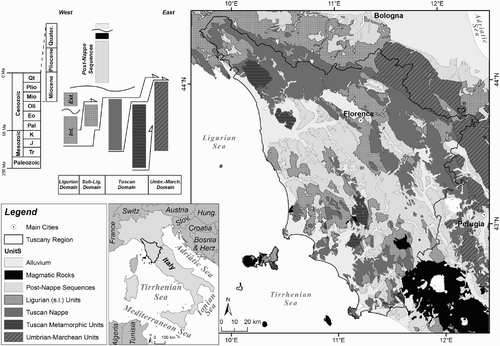
In the Northern Apennines orogenic wedge we recognize tectonic units originating from the African continent and relics of the Tethys oceanic crust. Successions derived from the oceanic crust outcrops in the entire region: the oceanic realm, named the ‘Ligurian domain’ in the Italian geologic literature, is part of the Alpine Tethys. It is furthermore separated in:
| • | Internal Ligurian Domain, which is characterized by the presence of Jurassic ophiolites and the Late Jurassic-Cretaceous sedimentary cover (cherts, Calpionella limestone and Palombini shales) associated with a Cretaceous-Paleocene siliciclastic turbidite sequence (Lavagna slates, Gottero sandstones and Bocco/Colli Tavarone shaly complex). | ||||
| • | External Ligurian Domain, which is characterized by the presence of Cretaceous-Paleocene calcareous-dominant f1ysch sequences (Helminthoid f1ysch) associated with complexes or pre-flysch formations called ‘basal complexes’. The pre-Cretaceous substrate is represented in part by ophiolites and in part by continental crust. Therefore, it is a domain that joined the oceanic area with the Apulia continental margin. | ||||
In the Internal and External Ligurian Domains are represented for simplicity with the same color.
Moving toward the African continent the ‘Subligurian Domain’ is distinguished. This is an intensely deformed Paleogene sequence (Canetolo Unit), whose original extent and substratum are unknown. This sequence was probably deposited in a transitional area between the oceanic and Apulia continental crust.
The Tuscan Domain represents the western margin of the Apulia continental crust that outcrops in the Italian peninsula, with the following distinctions:
| • | The Internal Tuscan Domain (Tuscan Nappe), with non-metamorphic (to low-grade metamorphic) formations of Late Triassic to Early Miocene age. | ||||
| • | The External Tuscan Domain (Tuscan Metamorphic Nappes), affected by greenschist facies metamorphism, with a Mesozoic-Tertiary succession that covers a Paleozoic basement with Hercynian deformation. | ||||
Moving toward the east, the Umbria–Marchean Domain is distinguished. This tectonic unit consists of carbonates belonging to the Jurassic–Paleogene multilayer and turibidites belonging to Neogene clastic wedge. This last only crops out in the eastern areas of Tuscany Region.
The sediments unconformably deposited after the main Tertiary tectonic phases are identified as sedimentary successions (post-nappe sequences), placed on the Tyrrhenian side of the Northern Apennines. These successions are separated by regional unconformities. From top to bottom they are: Pliocene to Quaternary continental and coastal deposits, Pliocene to Quaternary marine deposits, Messinian lacustrine, lagoonal evaporitic and pre-evaporitic deposit, EarlyTurolian lacustrine deposits and Epiligurian deposits. Finally, some lithostratigraphic units like magmatic intrusive and sub-volcanic rocks, effusive and pyroclastic rocks linked to Neogene magmatism and Quaternary cover have been grouped together.
3. Methods
3.1 Reference geological map and sampling strategy
The geological map of Tuscany at 1:250,000 scale (CitationCarmignani et al., 2012 submitted for publication) was used as a guide for the survey of natural radioactivity. The legend of the geological map was organized in to 45 items formed by groups of formations belonging to the tectonic domains ddescribed in Section 2.
The entire Tuscany Region (Italy) (22,994 km2) was investigated for the characterization of natural radioactivity by collecting 865 rock samples. The sampling was guided by criteria closely related to the reference geological information. Except for alluvial deposits, the samples come from outcrops with fresh rocks, selected in order to characterize the composite lithologies of the geological groups. Sampling was performed in order to allow a coherent statistical coverage for all 45 geological groups. At least one sample was collected every 80 km2 for each geological group with an overall average of one sample per 25 km2.
3.2 Gamma-ray spectrometry measurements and results
The specific activities of 40K, 238U and 232Th were measured in 865 representative rock samples by using a high-purity germanium (HPGe) gamma-ray spectrometer. Each rock sample was crushed, homogenized (less than 2 mm fine grain size) and constant weight dried at 110°C temperature. Then, each sample was sealed in a 180 cm3 cylindrical polycarbonate container. After sealing, each container was left undisturbed for at least four weeks before spectrum acquisition: this step provides enough time to establish secular equilibrium between 226Ra and 222Rn. The measurements were performed by using the MCA_Rad system (CitationXhixha et al., 2013). This is a fully automated high-resolution gamma-ray spectrometer, composed of two 60% relative efficiency coaxial HPGe p-type detectors, having an energy resolution of about 1.9 keV at 1332.5 keV (60Co) and efficiency estimated with an overall uncertainty of 5%.
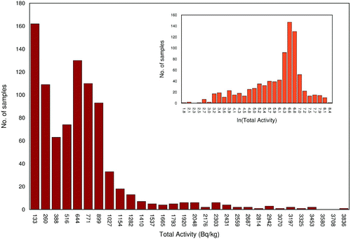
Adopting a log-normal distribution as a fundamental law of geochemistry, we enhance the presence of high values contained in the tails of the distributions of 40K, 238U and 232Th (CitationAhrens, 1954). The total activity was calculated for each geological group, by using the Monte Carlo technique: in particular, by summing the generated pseudo-random matrices (with up to 105 records) following the individual probability functions (for potassium, uranium and thorium). shows the distribution of total activity for the records.
Figure 2. Histogram of total activity for 865 samples; that demonstrates logarithmic distribution with the inset showing a log transformation that conforms to a normal distribution.
3.3 Mapping the radiometric data
The map of total activity was constructed based on the median values of the distributions of 40K, 238U and 232Th for each geological group. A total of 28 records, which are found to be outliers (i.e. exceeding the median ± 1.5 Inter Quartile Range) using the graphical box-plot, were rejected from the analysis. Subsequently the median and 1σ uncertainty of the total activity were calculated for each geological group. The reclassification of the geological groups was performed based on their radiometric response by using a geographical information system (GIS). To avoid arbitrary classes and any distribution of records, we represent total activity choosing the percentiles which are simply based on order statistics (CitationReimann, 2005). In particular seven classes of total activity are identified, choosing the 10%, 30%, 50%, 70%, 85% and 100% percentiles, almost evenly spread across the range of values. In order to emphasize the ‘high’ values we added an extra class of total activity chosen at the 95% percentile.
4. Conclusions
This study is the first extended investigation of natural radioactivity in rocks, performed in the Tuscany Region (Italy). A total of 865 samples distributed over 45 geological groups were collected guided by the geological map of Tuscany at 1:250,000 scale. In particular, on average of at least one sample per 80 km2 was collected, with an overall average of one sample per 25 km2. The total activity for each geological group was calculated by measuring the activity concentrations of 40K, 238U and 232Th using a HPGe gamma-ray spectrometer. The results of this survey are represented by reclassifying the geological map of Tuscany for the median total activities.
The congruence between the total activity and the lithological characteristics of the geological groups is emphasized. In particular, the acid magmatic rocks of the Tuscan Magmatic Province in southern Tuscany, well-known for the highest content of natural radioactivity, are confirmed by these results. Furthermore, the carbonate rocks of Apuane Alps (External Tuscan Domain) as expected show the lowest total activity. These facts confirm the high degree of geological control on the radiometric response validating the method used for sampling and analysis.
Software
The geological map was digitalized using the ESRI ArcGIS 9.3 with final map production and layout completed using the Maplex extension for labeling management.
Main Map: Total Natural Radioactivity Map of Tuscany (Italy)
Download PDF (3.9 MB)Acknowledgements
This work is partly supported by Direzione Generale Politiche Formative, Beni e Attività Culturali (Regione Toscana), partly by the Istituto Nazionale di Fisica Nucleare (INFN) and partly by Centro di GeoTecnologie (Università di Siena) and Fondazione Cassa di Risparmio di Padova e Rovigo. Authors would like to thank for their continuous support: Istituto Geografico Militare, Dipartimento di Scienze della Terra (University of Pisa), Litografia Artistica Cartografica and Litografia Artistica Cartografica. A special thanks goes to Antongiovanni M., Bellotti E., Blasi P., Di Carlo G., Fabbri A., Fabbri P., Fantozzi P. L., Mariani S., Morini D., Pagotto C., Shyti M. and Vannucci R. for helping us collect samples and develop the map.
Related Research Data
References
- Ahrens , L. H. 1954 . The lognormal distributions of the elements. (A fundamental law of geochemistry and its subsidiary) . Geochimical Cosmochimical Acta , 5 : 49 – 73 . doi: 10.1016/0016-7037(54)90040-X
- Anagnostakis , M. J. , Hinis , E. P. , Simopoulos , S. E. and Angelopoulos , M. G. 1996 . Natural radioactivity mapping of Greek surface soils . Environment International , 22 ( 1 ) : S3 – S8 . doi: 10.1016/S0160-4120(96)00085-2
- Andjelov , M. and Brajnik , D. 1996 . Map of natural radioactivity and radon emanation in Slovenia . Environment International , 22 ( 1 ) : S799 – S804 . doi: 10.1016/S0160-4120(96)00186-9
- Barchi , M. R. , De Feyter , A. , Magnani , M. B. , Minelli , G. , Pialli , G. and Sotera , B. G. 1998 . The structural style of the Umbria-Marche fold and thrust belt . Memorie della Società Geologica Italiana , 52 : 557 – 558 . ISSN: 0375-9857
- Boccaletti , M. , Elter , P. and Guazzone , G. 1971 . Plate tectonics model for the development of the Western Alps and Northern Apennines . Nature , 234 : 108 – 111 . doi: 10.1038/physci234108a0
- Carmignani, L., Conti, P., Cornamusini, G., & Pirro, A. (2012). The geological map of Tuscany (Italy). Submitted for publication to Journal of Maps.
- Carmignani , L. , Decandia , F. A. , Disperati , L. , Fantozzi , P. L. , Kligfield , R. , Lazzarotto , A. , Liotta , D. and Meccheri , M. 2001 . “ Inner Northern Apennines ” . In Anatomy of an Orogen: The Apennines and adjacent Mediterranean basins , Edited by: Vai , G. B. and Martini , I. P. 197 – 214 . Dordrecht (The Netherlands) : Kluwer Acad. Publ .
- Cornamusini , G. , Ielpi , A. , Bonciani , F. , Callegari , I. and Conti , P. 2012 . Geological map of the Chianti Mts (Northern Apennines, Italy) . Journal of Maps , 8 ( 1 ) : 22 – 32 . doi: 10.1080/17445647.2012.668423
- Council Directive 96/29/Euratom - ionizing radiation of 13 May 1996 laying down basic safety standards for the protection of the health of workers and the general public against the dangers arising from ionizing radiation.
- D.Lgs. 26 May 2000, nr. 241. Decreto Legislativo 26 maggio 2000, nr. 241 – Attuazione della direttiva 96/29/Euratom in materia di protezione sanitaria della popolazione e dei lavoratori contro i rischi derivanti dalle radiazioni ionizzanti – GU n.203 del 31/08/00.
- EURATOM Treaty. (1957). The Treaty establishing the European Atomic Energy Community (Euratom). Retrieved from LexNet website: http://www.lexnet.dk/law/subjects/treaties.htm
- Grasty , R. L. 1975 . Uranium measurement by airborne gamma-ray spectrometry . Geophysics , 40 : 503 – 519 . doi: 10.1190/1.1440542
- Grasty , R. L. and LaMarre , J. R. 2004 . The annual effective dose from natural sources of ionising radiation in Canada . Radiation Protection Dosimetry , 108 ( 3 ) : 215 – 226 . doi: 10.1093/rpd/nch022
- Martini , I. P. and Sagri , M. 1993 . Tectono-sedimentary characteristics of late miocene-quaternary extensional basins of the Northern Apennines, Italy . Earth Sciences Reviews , 34 : 197 – 233 . doi: 10.1016/0012-8252(93)90034-5
- Mikšová , J. and Barnet , I. 2002 . Geological support to the National Radon Programme (Czech Republic) . Bulletin of the Czech Geological Survey , 77 ( 1 ) : 13 – 22 . ISSN: 1210-3527
- Minty , B. R. S. 2011 . Airborne geophysical mapping of the Australian continent . Geophysics , 76 ( 5 ) : A27 – A30 . doi: 10.1190/geo2011-0056.1
- Reimann , C. 2005 . Geochemical mapping: Technique or art? . Geochemistry: Exploration, Environment, Analysis , 5 ( 4 ) : 359 – 370 . doi: 10.1144/1467-7873/03-051
- Rybach , L. , Bachler , D. , Bucher , B. and Schwarz , G. 2002 . Radiation doses of Swiss population from external sources . Journal of Environmental Radioactivity , 62 : 277 – 286 . doi: 10.1016/S0265-931X(01)00169-2
- Štány Geologický Ústav Dionýza Štúra. Geophysical maps SR M 1: 500.000. Retrieved from Štány Geologický Ústav Dionýza Štúra website: http://www.geology.sk/?pg=geois.ms_gf-500_mpr_en
- Xhixha , G. , Bezzon , G. P. , Broggini , C. , Buso , G. P. , Caciolli , A. , Callegari , I. , De Bianchi , S. , Fiorentini , G. , Guastaldi , E. , Mantovani , F. , Massa , G. , Menegazzo , R. , Mou , L. , Pasquini , A. , Rossi Alvarez , C. , Shyti , M. and Xhixha Kaçeli , M. 2013 . The worldwide NORM production and a fully automated gamma-ray spectrometer for their characterization . Journal of Radioanalitical and Nuclear Chemistry , 295 : 445 – 457 . doi: 10.1007/s10967-012-1791-1
- Zhuo , W. , Chen , B. , Li , D. and Liu , H. 2008 . Reconstruction of database on natural radionuclide contents in soil in China . Journal of Nuclear Science and Technology , 6 : 180 – 184 .