Abstract
A new fluvial terrace map with a tectonic framework for the northwest Iberian lower Miño River is presented. It is the first integrated map to cover the entire lower, 67-km reach of the Miño River, and to cover both the Spanish and Portuguese side of the river. The map is presented at a scale of 1:200,000, although its features were mapped at a scale of 1:5000. Various map layers can be viewed, such as a digital elevation model (DEM), fluvial sediment thickness layers, a palaeoflow direction layer, a lineament and fault layer, and two terrace and tectonic basin layers, showing up to 10 fluvial terraces and a floodplain level. Interpretation of the map shows that next to regional tectonic uplift and glacioeustacy, local basin subsidence and small-scale block movement are very important for the fluvial network, localised fluvial terrace formation, and preservation.
1. Introduction
River terraces are former river channels and floodplains that are situated at positions above the present river bed. They are either aggradational or erosive geomorphological surfaces that were subsequently incised. The incision forms a terrace riser or terrace scarp. Incision can be caused by changes in the ratio sediment load: water discharge, which is normally a climatically induced change (e.g. CitationStarkel, 2003); or because of changes in base level, induced by either sea level changes or tectonic uplift (CitationBridgland & Westaway, 2008a). Tectonic uplift is considered a prerequisite in preserving terraces above the current river bed (CitationMaddy, 1997; CitationViveen et al., 2013). A distinction is made (cf CitationLeopold, Wolman, & Miller (1964) as cited in CitationLewin & Gibbard, 2010) between ‘fill-cut’ terraces, whereby incision occurs after sediment deposition; ‘cut-fill’ terraces whereby multiple incision and aggradation events occur within one terrace level; and ‘strath’ terraces, the resultant of purely lateral planation and vertical incision into bedrock. These strath terraces usually only have a thin sediment cover, or sediments are not present.
Because river terraces can be formed by a variety of regional or even global factors (climate changes, tectonics), they are often used to assess the importance of these factors on landscape formation (CitationBridgland & Westaway, 2008a). Studies of river terrace formation usually involve a plethora of research techniques (CitationStokes, Cunha, & Martins, 2012). These include the use of digital elevation models (DEMs), aerial photographs, topographical and geological maps to provide an overview of regional terrace distribution; field work to map terrace distribution (e.g. CitationMeikle, Stokes, & Maddy, 2010), and to collect sediment samples for laboratory analysis; dating of fill and strath terraces using fossils or radiometric techniques (e.g. CitationCordier et al., 2012); and more recently, numerical modelling to investigate the processes behind terrace formation (CitationViveen et al., 2013).
In this paper, the terraces of the lower Miño River are presented. The Miño terraces record base level changes, climate changes and a variety of tectonic influences that makes it an important example for further studies on terraces world-wide (CitationViveen, Van Balen, et al., 2012), (CitationViveen, Braucher, et al., 2012), and (CitationViveen et al., 2013). The lower Miño River has been a topic of study for over 70 years (e.g. Citation Alves, 2004; CitationButzer, 1967; CitationCano-Pan et al., 1997, Citation1999; CitationLautensach, 1945; CitationNonn, 1967; CitationTeixeira, 1952; CitationYepes-Temiño, 2002), but a detailed, regional terrace map covering both the Spanish and Portuguese river bank has so far been lacking. This has impeded a coherent, regional overview of the lower Miño River terraces and their palaeoenvironmental significance (CitationViveen et al., 2013). For this reason, a new map for the entire area is presented here. The new terrace map had to fulfil a number of objectives, which are outlined below:
(i) refinement of the terrace stratigraphic framework; (ii) improvement of terrace correlations along the entire lower Miño River; (iii) revised chronology based on recent luminescence and cosmogenic ray exposure dating, and numerical modelling results; (iv) correct depiction of the newly discovered tectonic basins (CitationViveen, Van Balen, et al., 2012); and most importantly, (v) give an insight into where and in what structural context the terraces were formed. For this reason we have added several other map layers. There is a terrace map layer that shows terrace scarps, bedrock gorges, and tectonic elements, a lineament and fault layer, a palaeoflow direction layer and fluvial sediment thickness layers. Earlier versions of parts of the map were already published in CitationViveen, Van Balen, et al. (2012), (CitationViveen, Braucher et al., 2012), and (CitationViveen et al., 2013), but the map presented in this work contains fully updated terrace numbering, positions of tectonic basins as well as previously unpublished sediment thicknesses and palaeoflow directions.
2. Regional geological setting
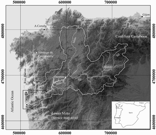
The Miño-Sil River system is situated in NW Iberia (), where Palaeozoic crystalline rock (gneisses and granites) and Palaeozoic metasedimentary rocks (schists and slates) dominate. During the late Variscan deformation phase, a large number of predominantly left-lateral NNE-SSW to ENE-WSW and right lateral NNW-SSE to NW-SE strike-slip faults were formed (CitationRibeiro, 1990). These were reactivated during the late Triassic rifting phase and subsequent younger deformation phases (CitationPinheiro, Wilson, Pena dos Reis, Whitmarsh, & Ribeiro, 1996). Differential uplift of tectonic blocks during the Mesozoic caused the formation of various flat surfaces, which step down from 1500 m inland to 600 m at the coast, where the Miño River estuary is located (CitationMartin-Gonzalez, 2009; CitationVidal-Romani & Yepes-Temiño, 2001). From the Cretaceous to the early Cenozoic, NNW-SSE to E-W normal to oblique-normal faulting occurred, as well as strike-slip and thrust faulting (CitationAnton, Muñoz-Martin, & De Vicente, 2010; CitationDe Vicente & Vegas, 2009). The Alpine deformation at the onset of the Tertiary caused uplift of the Cantabrian mountain range, and resulted in the reactivation of a number of fault systems such as NNE-SSW strike-slip systems, right-lateral transpressional NW-SE strike slip systems and also normal and thrust faulting (CitationDe Vicente & Vegas, 2009; CitationMartin-Gonzalez, 2009). During this time a number of small intramontane tectonic basins were also formed; first during the Oligocene-early Miocene in the Cantabrian Mountains and later on towards the Atlantic Iberian Margin during the middle-late Miocene (CitationDe Vicente, Cloetingh, Van Wees, & Cunha, 2011; CitationMartin-Gonzalez & Heredia, 2011). In the lower Miño area, active faulting, basin subsidence and regional vertical deformation occurred from at least the beginning of the middle Pleistocene onwards, and could be the result of on-going deformation processes along the Northern Iberian margin (CitationViveen, Van Balen et al., 2012), (CitationViveen, Braucher et al., 2012), and (CitationViveen et al., 2013). This resulted in an extensive fluvial terrace staircase (see next section ‘The Miño-Sil terrace record’).
Figure 1. Overview of the Miño-Sil catchment in NW Iberia. Figure adapted from CitationViveen, Braucher et al. (2012).
3. The Miño-Sil terrace record
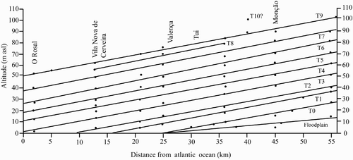
The present configuration of the Miño-Sil catchment is the result of the Tertiary deformation in western Iberia. Middle to late Miocene drainage reorganisation of almost the entire Iberian fluvial network, caused a change from an eastward draining system (towards the Iberian interior), to a westward draining system towards the Iberian Atlantic margin (CitationDe Vicente et al., 2011; CitationMartin-Gonzalez & Heredia, 2011). This caused the Sil River to start flowing towards the west during the middle Tortonian (CitationMartin-Gonzalez & Heredia, 2011). Headward erosion by the older Miño River (CitationVidal-Romani & Yepes-Temiño, 2001), captured the Sil probably sometime during the Pliocene (CitationPereira, Alves, Araujo, & Proença-Cunha, 2000). Fossils found in a clay layer underlying the oldest terraces of the Vila Meã section (CitationViveen, Braucher et al., 2012), yielded upper Pliocene ages (CitationVieira, Poças, Pais, & Pereira, 2011) and more recently, we demonstrated with results from cosmogenic ray exposure (CRE) dating, that the oldest lower Miño terraces date back to the Mid-Pleistocene transition (CitationViveen, Braucher et al., 2012). In the lower Miño area, up to 10 terrace levels and one floodplain level are present (CitationViveen et al., 2013), as well as a number of tectonic basins which were erroneously interpreted as fluvial terraces by other workers (CitationViveen, Van Balen et al., 2012). Typical spacing between terrace surfaces is 5–10 m. The terraces are generally fill-cut terraces and form large surfaces that are inclined towards the central valley axis in the broader sections of the Miño valley. In the narrower valley sections, terraces are smaller and often cut into the underlying bedrock and have less sediment (strath terraces).The terraces were formed under a regime of glacioeustacy and tectonic uplift (CitationViveen et al., 2013). The Miño terraces do not run parallel to the present river bed, but can be correlated on the basis of a downstream gradient of 1 m km−1 that was derived from correlating quartzite weathering rates and river profile modelling (CitationViveen et al., 2013, see ).
Figure 2. Long-distance terrace correlations of the lower Miño terraces. Figure adapted from CitationViveen et al. (2013). Terrace correlations are based on mapped terrace levels at seven transects, where (almost) complete terrace staircases were observed (indicated by black dots), changes in quartzite densities, and river profile evolution modelling results (CitationViveen et al., 2013).
4. Methodology
The Miño terrace map is drawn at a scale of 1:5000 and primarily based on a DEM with 5-m grid cell resolution (MDT5, IGN) and a vertical precision of 0.10 m. The spatial extent of the fluvial terraces was, in the first instance, based on the 1:50,000 scale geological map series of Spain and Portugal, and later on refined on the basis of a large number of field observations. Approximately 400 site descriptions were made during the years 2007, and 2009–2013. Their locations were mapped with a Garmin eTrex Summit HC Handheld Global Positioning System (GPS) with a differential GPS signal receiver. Signal precision was up to 1 m, although in most cases, precision of the signal was around 4 m. In total, over 1500 hours of fieldwork were invested in the lowermost 55 km of the lower Miño region. The terrace section in the uppermost 12 km of the area was mapped purely on basis of the geological maps and DEM. Fieldwork was aimed at the following characteristics, which are visible as separate map layers: (i) Fluvial sediment thickness. A differentiation is made between ‘exact’ and ‘minimum’ thickness, whereby in the case of exact thickness, the basal contact between fluvial gravels and underlying bedrock or saprolite was found; and not found in the case of minimum thickness. All terrace sediments consist of quartz and quartzite gravel (CitationViveen, Braucher et al., 2012), (CitationViveen et al., 2013), sometimes interbedded with clay or sand lenses; (ii) lineaments and faults. All faults are described in CitationViveen, Van Balen et al. (2012); all other elements are lineaments, which have been mapped from the DEM; (iii) palaeoflow directions. These are mainly based on clast imbrication in the terrace sediments and occasionally on foresets in sand beds; (iv) terraces and tectonic basins. Only the larger terrace surfaces were mapped, although sublevels have been reported (CitationViveen et al., 2013). These were grouped together into a single terrace level. Only terraces with fluvial sediment (fill-cut terraces) were mapped, but in a few rare cases strath terraces were also included if this improved the visibility of the terrace level on the map. Tectonic basins were mapped on the basis of the criteria in CitationViveen, Van Balen et al. (2012): large flat surfaces with surface positions not in agreement with local terrace staircase positions; the presence of lineaments and fault scarps; fluvial sediment thicknesses surpassing 8–10 m.
The number of terraces and their correlations () are based on CitationViveen et al. (2013). Up to 10 terraces and the floodplain level were mapped. Terrace correlations were based on observed systematic changes in the density of quartzite pebbles in the terrace deposits, which are caused by weathering processes; and river profile modelling. Long-distance terrace correlations are approximate because terrace levels do not always perfectly fit the calculated correlation gradient of 1 m km−1. Their position can be situated above or below their ideally estimated position at that location, but this is never more than ± 1 terrace level ; T0 is the youngest terrace and T10 the oldest. The ages for T0 to T4 are based on results from a terrace formation modelling exercise (CitationViveen et al., 2013) and in agreement with CRE ages (CitationViveen, Braucher et al., 2012). Ages of T2-T6 are based on CRE ages (CitationViveen, Braucher et al., 2012). Ages of the more upstream terraces may differ significantly from the downstream ones, because the more upstream reaches of the river need more time to adapt to glacioeustically induced variations in base level (CitationViveen et al., 2013). The resulting map is projected in UTM N29, ED50 and is available in GeoPDF format (see Main Map), making it possible to turn on and off the various map layers, and to overlay the map with other georeferenced data.
5. Results of the fluvial terrace map
5.1. Mapped terrace levels
A continuous series of fluvial terraces is present in the lower Miño valley. Terraces often occur as small groups or blocks of terraces, that are separated from other terrace blocks by tectonic basins and lineaments. Terraces tend to have larger surfaces in the wider valley sections, and smaller surfaces in the narrower sections. Terrace scarps are often well preserved and mapped accordingly, especially in upstream areas where they are cut into bedrock, and not as easily eroded as downstream, where they are cut from thick stacks of alluvium. In terms of terrace levels, the most complete terrace staircases are found in the narrower valley sections. There, the Miño could probably only laterally migrate in one direction, and responded by asymmetric vertical incision to changes in sediment load and discharge. This resulted in a complete sequence of strath terraces incised into the underlying bedrock. East of Monção, the older terrace levels are not found, likely because the mountainous terrain and generally thin sediment cover favoured rapid erosion. In the uppermost reach (55–67 km), a bedrock canyon and very few terrace levels are found, probably because the influence of glacioeustacy waned due to distance to the coast (CitationViveen et al., 2013); and because of increased uplift which hampered terrace formation (CitationViveen, Van Balen et al., 2012). In the most downstream section, the youngest terrace levels are not found. They are probably buried below the current river bed (CitationViveen et al., 2013). In one instance, a T10 terrace is mapped (39 km, south bank), but it is not clear if this is a Miño terrace as it is not directly situated in the Miño valley. Terrace distribution, development of the fluvial terrace scarps and sediment thickness also indicate the sometimes wandering pattern of the course of the Miño, e.g. at 55–44 km. The terraces are alternating between the north and south bank, before the Miño enters a tectonic basin. While the Miño flowed through the tectonic basin, only one or two terrace levels (T3 and T4) were formed on the south bank.
5.2. Sediment thicknesses and palaeoflow directions
Terrace thicknesses show a variable pattern. There is a weak observed trend of thicker sediment stacks downstream (2–6 m) compared to upstream (0–2 m), but a more obvious observed trend is visible when comparing sediment thicknesses to fluvial terrace form. Areas with narrow, equally spaced terraces (e.g. at 38–40 km upstream from the ocean, and at 22–26 km) contain less sediment (0–2 m) than the areas with large, broad terrace surfaces where thicknesses reach up to 10 m (e.g. 50 km north bank) , 19–23 km south bank and at 3 km).
Palaeoflow directions (79 observations of imbrications and forests) indicate that the reconstructed flow was always directed downstream and observed flow directions were in general (sub)parallel to the downstream axes of the terraces. Exceptions are found in tectonic basins (e.g. 23 km south bank and 14 km north bank), most likely because they are local depressions.
5.3. Lineaments, faults and basins
A total of nine tectonic basins were mapped. All basins are rhomboid-shaped, similar in size and very small (< 5 km2). The basin at 29–34 km contains a structure on the north side that is visible as a depression in the landscape. CitationPliego-Dones, Rubio-Navas, & Abril-Hurtado (1972) mapped the structure as an alluvial fan, but it is more likely a sag pond (Citationsensu Burbank & Anderson, 2001). This interpretation is based on its form, small extent and the fact that the nearby N-S trending lineament was interpreted as a left-lateral strike-slip fault (CitationDe Vicente & Vegas, 2009). Another sag pond is found at 25 km. Palaeoflow directions in the tectonic basin north of the sag pond at 31 km, indicate a northward direction. This shows that the basin was indeed filled with Miño sediments, as suggested by CitationSos-Baynat (1965). The basin is part of a larger N-S trending valley, but as fluvial terraces of the Miño are only found close to the Miño River, the remainder of the valley is not mapped. In many cases, the basins are subdivided into smaller basins, leading to a system of individually subsiding compartments, or blocks, for instance between 22–26 km (east bank), and 29–33 km.
The terrace distribution and tectonic basins are clearly structurally controlled. Three types of lineament directions delimit the tectonic basins. These are (i) E-W to ESE-WNW lineaments; clear examples are the lineaments controlling the basins between 22 and 0 km; (ii) NW-SE trending faults (e.g. the basin at 47–48 km (CitationViveen, Van Balen et al., 2012); and (iii) approximately N-S-trending lineaments. The E-W and N-S trending lineaments are also responsible for the faulting of terrace surfaces. A clear example is found at 34–35 km (south bank), where the western part of the T3 terrace surface has subsided 10 m.
Structural control on the terraces is evident from the sometimes long, narrow and straight configuration of the terraces without any obvious meandering. Between 22 and 31 km (north bank) all terraces (T0 to T9), are aligned in a NNE-SSW; and at 21–23 km, all terraces are of similar size and trend NE-SW.
6. Discussion and conclusions
The results indicate that the occurrence of terraces and their sediment thicknesses depends on more factors than downstream distance alone. The most well-developed terraces are situated in wider parts of the Miño valley, where a well-developed network of lineaments is present (typically the N-S oriented parts). In areas where these structures are absent, fewer fluvial terraces are found. This is obvious for the lowermost 15 km, where no well-developed network of lineaments exists on the south bank, and only terraces on the north bank are preserved. It is likely that former strike-slip activity along these faults caused weakening of the bedrock by cataclastic shearing. Strike-slip activity may be deduced from the broad and flat-bottomed tributary valley at 40 km (south bank) which may be the result of sheared bedrock; and the two structures interpreted as sag ponds along a N-S trending lineament. This supports the hypothesis that left-lateral strike-slip faulting was occurring along the N-S trending lineaments (CitationDe Vicente & Vegas, 2009).
The three lineament orientations (E-W to ESE-WNW, NW-SE and N-S) isolate a large number of small blocks that form separate entities in the landscape (tectonic basins and small blocks of terraces). The results indicate that the Miño, while flowing across such blocks, was often forced to migrate in a predetermined direction. Another clear example is found between 40 and 50 km, where the oldest terrace levels on the south bank have positions that are consistently 10 m higher when compared to the terraces on the north bank. In this reach, the Miño likely flows across an active E-W trending fault. This suggests unequal uplift on both sides of the river bank, possibly induced by a northward tilt of the south block. In response, the Miño shifted northward. This and other examples on the map suggest that local block movement was also an important factor for terrace formation and preservation. Differential uplift of blocks has been observed in other river systems, for instance in southern Iberia (CitationCunha, Martins, Huot, Murray, & Raposo, 2008; CitationMartins et al., 2009), Germany (Peters & Van Balen, Citation2007), and the Netherlands (CitationVeldkamp & Van den Berg, 1993), but always on a larger spatial scale or over longer time periods (Citatione.g. Bridgland et al., 2012; CitationDemir et al., 2012). As far as we are aware, such potentially small-scale differential block movements affecting terraces in such a persistent manner have not yet been reported. The results from our map also indicate that faulting has been active during terrace formation in the Miño valley, which is from the Mid-Pleistocene transition period until now (CitationViveen, Braucher et al., 2012).
The influence of glacioeustacy has been thoroughly investigated in CitationViveen et al. (2013), and is clearly visible on the terrace map, where terraces increase in altitude from the coast towards the upstream reaches. The proximity of a narrow, steep continental shelf caused profound changes in river gradient when sea level dropped, as the Miño had to adapt to the new base level by incision. This led to terrace threads with a much steeper gradient than the current floodplain. Similar strong control of base level has been reported for other areas with short steep continental shelves around the world, for instance in southwest Iberia (CitationVis, Kasse, & Vandenberghe, 2008) and the United States (CitationBlum & Aslan, 2006; CitationBlum & Törnqvist, 2000). Climate-induced variations in discharge and sediment supply on the other hand, seemed to have had a less important effect on terrace formation as suggested by modelling experiments (CitationViveen et al., 2013).
In this sense, the Miño River system is very different from many other river systems in the world, where climate change is a major driver for terrace formation and base level has a less prominent (but still important) influence (CitationBridgland & Westaway, 2008a). Tectonic uplift is becoming more and more accepted as another important driver for terrace preservation (CitationBridgland & Westaway, 2008b). The results of our terrace map suggest that local, small-scale tectonic motion may also be of importance, something that until now has remained poorly investigated within the fluvial terrace community. This opens up new possibilities of integrating fluvial terrace research with the field of tectonic geomorphology. Concluding, glacioeustacy, vertical tectonic motions, small-scale block movements, downstream distance, and structural basin control are all important factors for terrace formation and preservation.
Software
The map was made using ArcGIS 9.3.1 software.
Main Map: Fluvial Terrace Map of the Northwest Iberian Lower Miño River
Download PDF (10.8 MB)Acknowledgements
We would like to thank Augustin Cabria from the Instituto Geografico Nacional de España for providing the MDT5 (5-m resolution DEM), which made the mapping of both the Spanish and Portuguese side of the Miño River possible. The Land Dynamics group (now Soil Geography and Landscape) at Wageningen University provided financial assistance for the mapping process and the various field campaigns. Comments from Dr. Martin Stokes and two anonymous reviewers greatly improved the manuscript.
Related Research Data
References
- Alves , M. I. C. 2004 . “ A sedimentação fluvial Cenozoica na região do entre-Douro-e-Minho (NW de Portugal) ” . In Geomorfologia do noroeste da peninsula Iberica , Edited by: Araujo , M. A. and Gomes , A. A. 93 – 115 . Porto , , Portugal : Faculdade de letras da universidade do Porto .
- Anton , L. , Muñoz-Martin , A. and De Vicente , G. 2010 . Alpine paleostress reconstruction and active faulting in western Iberia . Central European Journal of Geosciences , 2 ( 2 ) : 152 – 164 . (doi:10.2478/v10085-010-0006-7)
- Blum , M. D. and Aslan , A. 2006 . Signatures of climate vs. sea-level change within incised valley-fill successions: Quaternary examples from the Texas Gulf Coast . Sedimentary Geology , 190 : 177 – 211 . (doi:10.1016/j.sedgeo.2006.05.024)
- Blum , M. D. and Törnqvist , T. E. 2000 . Fluvial response to climate and sea-level change: A review and look forward . Sedimentology , 47 ( Suppl. 1 ) : 2 – 48 . (doi:10.1046/j.1365-3091.2000.00008.x)
- Bridgland , D. and Westaway , R. 2008a . Climatically controlled river terrace staircases: A worldwide Quaternary phenomenon . Geomorphology , 98 ( 3–4 ) : 285 – 315 . (doi:10.1016/j.geomorph.2006.12.032)
- Bridgland , D. and Westaway , R. 2008b . Preservation patterns of Late Cenozoic fluvial deposits and their implications: Results from IGCP 449 . Quaternary International , 189 : 5 – 38 . (doi:10.1016/j.quaint.2007.08.036)
- Bridgland , D. R. , Westaway , R. , Romieh , M. A. , Candy , I. , Daoud , M. , Demir , T. , Galiatsatos , N. , Schreve , D. C. , Seyrek , A. , Shaw , A. D. , White , T. S. and Whittaker , J. 2012 . The river Orontes in Syria and Turkey: Downstream variation of fluvial archives in different crustal blocks . Geomorphology , 165–166 : 25 – 49 . (doi:10.1016/j.geomorph.2012.01.011)
- Burbank , D. W. and Anderson , R. S. 2001 . Tectonic geomorphology , Malden, USA : Blackwell Science .
- Butzer , K. W. 1967 . Geomorphology and stratigraphy of the Paleolithic site of Budiño . Eiszeitalter und Gegenwart , 18 : 82 – 103 .
- Cano-Pan , J. , Aguirre-Enriquez , E. , Giles-Pacheco , F. , Gracia-Prieto , J. , Santiago-Perez , A. , Mata-Almonte , E. , Gutierrez-Lopez , J. M. , Aguilera-Rodriquez , L. and Prieto-Reina , O. 1999 . “ Secuencia cronoestratigrafica y poblamiento paleolitico en la cuenca media-baja del rio Miño. Sector Tuy (Pontevedra)-Cortegada (Orense) ” . In Avances en el estudio del Cuaternario español Edited by: Palli-Buxo , L. and Roque-Pau , C. 231 – 240 . Girona , , Spain
- Cano-Pan , J. , Aguirre-Enriquez , E. , Giles-Pacheco , F. , Gracia-Prieto , J. , Santiago-Perez , A. , Mata-Almonte , E. , Gutierrez-Lopez , J. M. , Diaz-Del Olmo , F. , Baena-Escudero , R. and Borja , F. 1997 . Evolucion del Pleistoceno en la cuenca baja del Miño, sector La Guardia-Tuy . Secuencia de los primeros poblamientos humanos y registro arqueologico. Actas Cuaternario Iberico , Huelva, Spain, pp. 201–212
- Cordier , S. , Harmand , D. , Lauer , T. , Voinchet , P. , Bahain , J-J. and Frechen , M. 2012 . Geochronological reconstruction of the Pleistocene evolution of the Sarre valley (France and Germany) using OSL and ESR Dating Techniques . Geomorphology , 165–166 : 91 – 106 . (doi:10.1016/j.geomorph.2011.12.038)
- Cunha , P. P. , Martins , A. A. , Huot , S. , Murray , A. and Raposo , L. 2008 . Dating the Tejo river lower terraces in the Rodão area (Portugal) to assess the role of tectonics and uplift . Geomorphology , 102 : 43 – 54 . (doi:10.1016/j.geomorph.2007.05.019)
- Demir , T. , Seyrek , A. , Westaway , R. , Guillou , H. , Scaillet , S. , Beck , A. and Bridgland , D. R. 2012 . Late Cenozoic regional uplift and localised crustal deformation within the northern Arabian Platform in southeast Turkey: Investigation of the Euphrates terrace staircase using multidisciplinary techniques . Geomorphology , 165–166 : 7 – 24 . (doi:10.1016/j.geomorph.2012.01.005)
- De Vicente , G. , Cloetingh , S. , Van Wees , J. D. and Cunha , P. P. 2011 . Tectonic classification of Cenozoic Iberian foreland basins . Tectonophysics , 502 ( 1–2 ) : 38 – 61 . (doi:10.1016/j.tecto.2011.02.007)
- De Vicente , G. and Vegas , R. 2009 . Large-scale distributed deformation controlled topography along the western Africa-Eurasia limit: Tectonic constraints . Tectonophysics , 474 : 124 – 143 . (doi:10.1016/j.tecto.2008.11.026)
- Lautensach , H. 1945 . Formação dos terraços interglaciarios do norte de Portugal e suas relaçoes com os problemas da epoca glaciaria . Publ. Soc. Geol. Portugal , 1 : 5 – 44 .
- Leopold , L. B. , Wolman , M. G. and Miller , J. P. 1964 . Fluvial processes in geomorphology , San Francisco : Freeman .
- Lewin , J. and Gibbard , P. L. 2010 . Quaternary river terraces in England: Forms, sediments and processes . Geomorphology , 120 : 293 – 311 . (doi:10.1016/j.geomorph.2010.04.002)
- Maddy , D. 1997 . Uplift-driven valley incision and river terrace formation in southern England . Journal of Quaternary science , 12 ( 6 ) : 539 – 545 . (doi:10.1002/(SICI)1099-1417(199711/12)12:6<539::AID-JQS350>3.0.CO;2-T)
- Martin-Gonzalez , F. 2009 . Cenozoic tectonic activity in a Variscan basement: Evidence from geomorphological markers and structural mapping (NW Iberian massif) . Geomorphology , 107 : 210 – 225 . (doi:10.1016/j.geomorph.2008.12.008)
- Martin-Gonzalez , F. and Heredia , N. 2011 . Complex tectonic and tectonostratigraphic evolution of an Alpine foreland basin: The western Duero basin and the related Tertiary depressions of the NW Iberian peninsula . Tectonophysics , 502 ( 1–2 ) : 75 – 89 . (doi:10.1016/j.tecto.2010.03.002)
- Martins , A. A. , Cunha , P. P. , Huot , S. , Murray , A. S. and Buylaert , J. P. 2009 . Geomorphological correlation of the tectonically displaced Tejo River terraces (Gavião-Chamusca area, central Portugal) supported by luminescence dating . Quaternary International , 199 ( 1–2 ) : 75 – 91 . (doi:10.1016/j.quaint.2009.01.009)
- Meikle , C. , Stokes , M. and Maddy , D. 2010 . Field mapping and GIS visualisation of quaternary river terrace landforms: An example from the río almanzora, SE Spain . The Journal of Maps , 6 : 531 – 542 . (doi:10.4113/jom.2010.1100)
- Nonn , H. 1967 . Les terrasses du rio Mino inferieur . Localisation et etude sedimentologique. Revue de Geomorphologie Dynamique , 17 ( 3 ) : 97 – 108 .
- Pereira , D. I. , Alves , M. I. C. , Araujo , M. A. and Proença-Cunha , P. 2000 . Estratigrafia e interpretação paleografica do Cenozoico continental do norte de Portugal . Ciencias da Terra (UNL) , 14 : 73 – 84 .
- Peters , G. and van Balen , R. T. 2007 . Tectonic geomorphology of the Northern Upper Rhine graben . Global and Planetary Change , 58 : 310 – 334 . (doi:10.1016/j.gloplacha.2006.11.041)
- Pinheiro , L. M. , Wilson , R. C. L. , Pena dos Reis , R. , Whitmarsh , R. B. and Ribeiro , A. 1996 . The western Iberian margin: A geophysical and geological overview . Proceedings of the Ocean Drilling Program, part B: scientific results , 149 : 3 – 23 .
- Pliego-Dones, D., Rubio-Navas, J., & Abril-Hurtado, J. (1972). Hoja 261 Tuy. Mapa geologica de España 1:50.000. I.G.M.E. Madrid, Servicio de publicaciones del Ministerio de Industria y Energia.
- Ribeiro , A. 1990 . “ Geodynamic evolution of the Iberian Massif ” . In Pre-Mesozoic geology of the Iberian Peninsula , Edited by: Dallmeyer , R. D. and Martinez-Garcia , E. 399 – 409 . Berlin , , Germany : Springer Verlag .
- Sos-Baynat , V. 1965 . Geomorfologia del valle del Louro, Porriño, Tuy, Pontevedra . Bol. Geol. Min. , 76 : 3 – 49 .
- Starkel, L. (2003). Climatically controlled terraces in uplifting mountain areas. Quaternary Science Reviews, 22(20), 2189–2198.
- Stokes , M. , Cunha , P. P. and Martins , A. A. 2012 . Techniques for analysing Late Cenozoic river terrace squences . Geomorphology , 165–166 : 1 – 6 . (doi:10.1016/j.geomorph.2012.03.022)
- Teixeira, C. (1952). Os terraços da parte Portugesa do rio Minho Comunicações dos servicios geologicos de Portugal 33.
- Veldkamp , A. and Van den Berg , M. W. 1993 . Three-dimensional modelling of Quaternary fluvial dynamics in a climo-tectonic dependent system. A case study of the Maas record (Maastricht, The Netherlands) . Global and Planetary Change , 8 : 203 – 218 . (doi:10.1016/0921-8181(93)90009-D)
- Vidal-Romani , J. R. and Yepes-Temiño , J. 2001 . Las terrazas del rio Mino en el tramo Chantada-As Neves . Acta Geologica Hispanica , 36 ( 1–2 ) : 149 – 164 .
- Vieira , M. , Poças , E. , Pais , J. and Pereira , D. I. 2011 . Pliocene flora from S. Pedro da Torre deposits (Minho, NW Portugal) . Geodiversitas , 33 ( 1 ) : 71 – 85 . (doi:10.5252/g2011n1a5)
- Vis , G-J. , Kasse , C. and Vandenberghe , J. 2008 . Late Pleistocene and Holocene palaeogeography of the lower Tagus valley (Portugal): Effects of relative sea level, valley morphology and sediment supply . Quaternary Science Reviews , 27 ( 17–18 ) : 1682 – 1709 . (doi:10.1016/j.quascirev.2008.07.003)
- Viveen , W. , Braucher , R. , Bourlès , D. , Schoorl , J. M. , Veldkamp , A. , Van Balen , R. T. , Wallinga , J. , Fernandez-Mosquera , D. , Vidal-Romani , J. R. and Sanjurjo-Sanchez , J. 2012 . A 0.65 Ma chronology and incision rate assessment of the NW Iberian Miño River terraces based on 10Be and iuminescence dating . Global and Planetary Change , 94–95 : 82 – 100 . (doi:10.1016/j.gloplacha.2012.07.001)
- Viveen , W. , Schoorl , J. M. , Veldkamp , A. , van Balen , R. T. , Desprat , S. and Vidal-Romani , J. R. 2013 . Reconstructing the interacting effects of base level, climate, and tectonic uplift in the lower Miño terrace record: A gradient modelling evaluation . Geomorphology , 186 : 96 – 118 . (doi:10.1016/j.geomorph.2012.12.026)
- Viveen , W. , Van Balen , R. T. , Schoorl , J. M. , Veldkamp , A. , Temme , A. J. A. M. and Vidal-Romani , J. R. 2012 . Assessment of recent tectonic activity on the NW Iberian Atlantic margin by means of geomorphic indices and field studies of the lower Miño River terraces . Tectonophysics , 544–545 : 13 – 30 . (doi:10.1016/j.tecto.2012.03.029)
- Yepes-Temiño, J. (2002). Geomorfologia de un sector comprendido entre las provincias de Lugo y Ourense (Galicia, Macizo Hesperico). Serie Nova Terra 21, Laboratorio Xeoloxico de Laxe. O Castro, University of A Coruña.