Abstract
The Antarctic Peninsula has recently seen a rapid breakup of its peripheral ice shelves, attributed to atmospheric and oceanic warming in the region. Previous work has illustrated that the final breakup mechanisms are often controlled by the structural glaciology of the ice shelf, and thus understanding the structure of the remaining ‘stable’ ice shelves is of fundamental importance to assess their future response to continued environmental changes. The accompanying map presents the structural glaciology of Bach, George VI and Stange Ice Shelves in the southwest Antarctic Peninsula, from ca. 2010, with a description of each feature presented here.
1. Introduction
Over recent decades, the Antarctic Peninsula has seen a rapid recession of its peripheral ice shelves that buttress inland grounded ice (CitationCook & Vaughan, 2010). Their removal has led to the acceleration and thinning of their former feeder glaciers (e.g. CitationBerthier et al., 2012; CitationDe Angelis et al., 2003; CitationGlasser et al., 2011; CitationHulbe et al., 2008; CitationRott et al., 2002; CitationScambos et al., 2004) that have the potential to amplify global sea levels (CitationVaughan et al., 2003). Attributing the causes of breakup to a single mechanism is difficult due to the complexities of ocean-ice-atmospheric processes. However, the timing of ice-shelf collapse appears to be linked with the southern migration of the −9°C mean annual isotherm (CitationMorris & Vaughan, 2003). Furthermore, (CitationPritchard et al. 2012), amongst others, have suggested that breakup may also be linked to oceanic warming in the region (CitationMartinson et al., 2008; CitationRobertson et al., 2002).
The structural evolution of an ice shelf is visually recorded in surface features that can be accurately and repeatedly mapped to infer ice dynamics. Certain ice-shelf structures have been shown to play a critical role in determining ice-shelf stability (CitationBraun et al., 2009; CitationGlasser & Scambos, 2008; CitationHolt et al., 2013), so by recording the configuration of surface structures and how they evolve through time, it is often possible to infer their future longevity.
The map described in this paper documents the structural glaciology of Bach, George VI and Stange Ice Shelves on the southwest Antarctic Peninsula that are at, or near, the atmospheric limit of ice-shelf viability (CitationMorris & Vaughan, 2003) and also terminate into a warming Bellingshausen Sea (CitationHolland et al., 2010; CitationMeredith & King, 2005). Here we present an overview of the data and methods used, and a description of the surface structures recorded on the map which can be found as Supplemental Content to this article.
2. Study sites
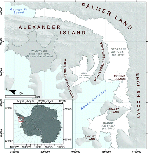
The study site comprises George VI, Bach and Stange Ice Shelves in the southwest Antarctic Peninsula (). George VI Ice Shelf (GVIIS) measured ∼ 23,370 km2 (in 2010), Bach ∼ 4540 km2 (in 2011) and Stange ∼ 7920 km2 (in 2011) (CitationHolt, 2013), and all have been subject to recession and thinning since at least the second half of the twentieth century (see CitationCook & Vaughan, 2010; CitationFerrigno et al., 2009; CitationFricker & Padman, 2012). George VI Ice Shelf is by far the most intensely studied of the ice shelves investigated here, with relatively little work undertaken on Bach or Stange Ice Shelves. The reader is directed to CitationHolt et al. (2013), CitationSmith et al., (2007), CitationHumbert (2007) and CitationReynolds and Hambrey (1988) for a more thorough discussion of George VI Ice Shelf.
Figure 1. Location of Bach, George VI and Stange Ice Shelves in the Antarctic Peninsula. Wilkins Ice Shelf is not considered in this study, and the reader is directed to CitationBraun et al. (2009) for a thorough structural interpretation. Insert: MODIS Image Mosaic of Antarctic (CitationHaran et al., 2005).
3. Data, methods and software
Structural mapping was carried out in ArcMap 9.3 Geographical Information System (GIS) software using time-separated satellite images following the procedures of CitationGlasser and Scambos (2008) and CitationHolt et al. (2013). Digitised features included the location of the ice front and ice-shelf grounding zone, rifts, fractures, fracture traces, crevasses and crevassed zones (fields), longitudinal structures (elsewhere termed flow stripes, flow bands, foliation), transverse structures, pressure ridges, ice rises, ice rumples and ice dolines.
Structural and surface-feature mapping was performed using Landsat ETM+ () Panchromatic Band 8 (0.52–0.90 µm, 15 m) that offers the greatest contrast between surface features and the surrounding ice-shelf surface, and the best spatial resolution. Standard image-enhancement stretches (e.g. Gaussian stretching, equalisation) were applied on an image-by-image basis to improve the appearance of surface features during digitisation.
Table 1. List of Landsat scenes used for structural mapping.
Digitising was carried out at three main scales for consistency across all ice shelves: (1) 1:100,000 was used for large surface features such as confluence zones and longitudinal structures; (2) 1:50,000 was used for fractures, rifts, the ice front and the grounding zone; and (3) 1:25,000 was used for crevasses, crevassed zones, transverse structures and pressure ridges. Other features, such as ice dolines and ice rises, were mapped at scales appropriate to their individual characteristics.
Surface meltwater was automatically classified in Definiens Developer 7.0 (eCognition) using a multi-resolution segmentation and image-object classification approach. The Landsat images were segmented using the inherent spectral difference between snow, ice and surface meltwater. A shape factor (that determines the overall geometry of each spectral segment and defines the textural homogeneity of the resulting objects) was set at 0 (on a scale of 0–1) to ensure the spectral reflectance of the chosen image band was the main determinate of the image objects rather than segment shape. A compactness value of 1 (on a scale of 0–1) was also used to ensure that the final segmentation process was based solely upon the distinct spectral properties of the image band. The resulting image objects thus had no pre-determined shape, but reflected the nature of the spectral properties of the meltwater. Resulting image objects were thus shaped according to the contrast between the surface meltwater and surrounding ice surface at a scale comparable to the chosen imagery, with those areas containing surface meltwater classified accordingly based on user-defined statistical thresholds extracted from the segmented image objects. The final map is presented in a Polar Stereographic (metres) projection with a WGS84 datum, and displayed at a 1:1,000,000 scale.
4. Description of glaciological features and structural glaciology
4.1. Ice front
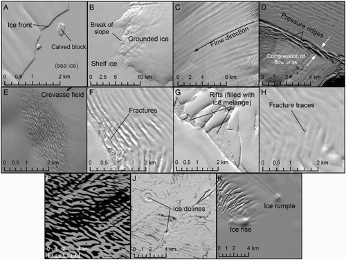
The ice front was identified as the sharp transition from shelf ice to either: (1) open water (typically during austral summer) or; (2) sea ice (austral winter, multi-annual sea ice), observed as a bright-sunlit or dark-shaded sub-linear feature (depending on its orientation with respect to the Sun's azimuth) ((A)). The ice front is a clear indicator of the maximum ice-shelf extent for a particular time period.
Figure 2. Feature identification in Landsat ETM+ Panchromatic Band 8 as discussed in the main text. (A) An ice front and adjacent sea ice, (B) the grounding line/ break of slope, (C) longitudinal structures (flowlines), (D) pressure ridges (also termed pressure rollers), (E) crevassing on grounded ice, (F) fractures emanating from the grounding line, (G) rifts filled with ice melange, (H) fracture traces (healed fractures), (I) surface meltwater on George VI Ice Shelf, (J) ice dolines, (K) an ice rise and ice rumple.
4.2. Grounding zone
Identified as a sudden break in slope in the optical imagery, or an area of intense crevassing, that represents the transition from grounded ice of the interior ice sheet and floating shelf ice. The grounding zone has several distinct features including the limit of ice flexure from tidal forcing, the limit of ice flotation, an inflexion point (break of slope) and the point where the floating ice reaches hydrostatic equilibrium (CitationFricker & Padman, 2006; CitationVaughan, 1994). Here, the grounding zone has been mapped as the break of slope as it is the most distinct feature in satellite imagery ((B)). The true grounding line is likely to be a few hundred metres further upstream. The area between the ice front and the grounding zone represents the total ice-shelf area that fluctuates with a change in ice-shelf mass balance.
4.3. Longitudinal structures
Longitudinal structures (also termed flow stripes (e.g. CitationCasassa et al., 1991)), flow bands (e.g. CitationSwithinbank et al., 1988) and streaklines (e.g. CitationHulbe et al., 2004) are extended features aligned parallel to the principal ice-flow direction and are observed as dark and light couplets caused by shaded surface relief ((C)). They are ubiquitous around Antarctica (CitationGlasser & Gudmundsson, 2012) and typically exist in regions of ‘active’ ice, with their cumulative length governed by the timescale of decay relative to the time taken for ice to travel a certain distance, yet their genesis is unclear. Although some field measurements have been acquired (e.g. CitationCampbell et al., 2008; CitationHulbe et al., 1997; CitationNg & Conway, 2004), many of the opposing theories of origin have been developed through numerical modelling (e.g. CitationGudmundsson et al., 1998), remote sensing-based analysis (CitationCampbell et al., 2008; CitationCasassa & Brecher, 1993; CitationGlasser & Gudmundsson, 2012; CitationRaup, Scambos, & Haran, 2005) and transfer of theory developed on valley-glacier structures (e.g. CitationReynolds & Hambrey, 1988). Subsequently, three key mechanisms have been proposed to explain their formation:
| 1. | They form through lateral compression followed by longitudinal extension via processes similar to foliation on temperate glaciers (CitationHambrey, 1977; CitationHooke & Hudleston, 1978); | ||||
| 2. | They are indicative of shear margins between flow units (CitationMerry & Whillans, 1993); | ||||
| 3. | They are the surface expression of subglacial bed topography transmitted to the surface in regions of fast-flowing ice (CitationGudmundsson et al., 1998). | ||||
4.4. Pressure ridges
Pressure ridges form in various circumstances, but represent areas where the ice shelf has deformed under longitudinal or transverse compression. Unlike longitudinal features, little scientific investigation has been carried out on pressure-ridge structures. In satellite imagery they are identified as singular or successions of elongated shaded ridges above the surface of the surrounding ice ((D)).
Pressure ridges on Antarctic Ice Shelves have been recognised as important indicators of stress and strain rates, most strikingly along the Alexander Island grounding zone of George VI Ice Shelf (CitationReynolds & Hambrey, 1988), although similar features were also found on the McMurdo Ice Shelf (CitationCollins & McCrae, 1985) and in portions of the Ross Ice Shelf (CitationKehle, 1964). Pressure-ridge dimensions vary, with CitationWright and Priestley (1922) identifying amplitudes of 12 m and wavelengths of 3.2 km on Beardmore Glacier, CitationGould (1935) commenting on ridges 9 m high and 1.2 km in wavelength on Shackleton Ice Shelf, and CitationKehle (1964) describing pressure rollers with amplitudes of 12–15 m and wavelengths of 180–650 m on the Ross Ice Shelf. On George VI Ice Shelf, CitationReynolds and Hambrey (1988) identified ridges 15 m high where the dominant westward flow caused transverse foliation under increasing longitudinal compression against Alexander Island. More recently, CitationLabarbera and MacAyeal (2011) modelled the formation of en echelon meltwater lakes on George VI Ice Shelf within the troughs between pressure ridges, along the margin of Alexander Island. Pressure ridges are thus indicative of high compressional stresses typically perpendicular to their length.
4.5. Crevasses, fractures and rifts
Fracturing of ice occurs when a temperature-dependant threshold is exceeded, with structures aligned perpendicularly to the direction of maximum tension. Here, crevasses are defined by open fractures that form on grounded ice, and cross the grounding zone with ice motion ((E)). The term fracture is given to any surface opening that forms within the ice-shelf itself ((F)), with the term rift given to large fractures that visibly penetrate the entire depth of the ice shelf surface ((G)). Rifts are often filled with open water, sea ice, or a mélange of calved shelf ice, sea ice and water. All three terms describe structures that form in areas of tensile or shear stresses caused by the motion of ice. Fracture traces are former crevasses, fractures or rifts that leave a distinct imprint on the surface, but do not have a visible opening ((H)).
4.6. Surface meltwater
Surface meltwater is easily identifiable ((I)) due to the spectral differences between it and the surrounding bare ice or snow of the ice-shelf surface. Visible meltwater indicates areas of surface ablation and can suggest ice-shelf surface-slope orientation where flow direction can be derived. Furthermore, assessing a time-series of surface meltwater extent can indicate changing atmospheric temperatures. Surface meltwater has been identified on Bach and George VI Ice Shelves, but Stange Ice Shelf remains free of meltwater from at least 1973 to present (CitationHolt, 2013).
4.7. Ice dolines
Ice dolines are large, sub-rounded hollows often filled with surface meltwater during the austral summer (CitationBindschadler et al., 2002; CitationMacAyeal & Sergienko, 2013) that form in areas of extensive surface melt, and may suggest weaker areas of shelf ice (CitationBindschadler et al., 2002). Ice dolines typically exist in three distinct zones: (1) in previously crevassed ice; (2) where an abundant supply of surface meltwater is available; and (3) in clusters at or near to flow unit boundaries. Indeed, all ice dolines only occur in areas where some meltwater is present. Once formed, the horizontal dimensions of ice dolines alter depending on the stress and strain rate of the surrounding ice, elongating with extensional flow either longitudinally or transversely. Visual inspection of shadowing of individual ice dolines suggests steep-sided cliffs around an internal crater ((J)).
4.8. Ice rises and ice rumples
Ice rises and ice rumples are elevated portions of the ice-shelf surface caused by grounding on sub-glacial topography. Ice rises occur where the shelf becomes pinned on the bedrock, whereas ice rumples form where ice-shelf motion is still possible over the bedrock. Both features have similar surface expressions and their identification is dependent on the visibility of other glaciological surface features such as pressure ridges upstream and fracturing downstream ((K)).
5. Conclusions
The map described here presents the structural glaciology of southwest Antarctic Peninsula Ice Shelves that forms part of a larger research project into the stability of southwest Antarctic Peninsula ice-shelf systems (CitationHolt, 2013; CitationHolt et al., 2013). We have also provided information on the glaciological structures that appear on Bach, George and Stange Ice Shelves in order for the reader to interpret their glaciological structural regime for ca. 2010.
Software
Esri ArcGIS 9.3 was used for all structural mapping and the production of the final map.
Main Map: The Structural Glaciology of Southwest Antarctic Peninsula Ice Shelves (ca. 2010)
Download PDF (11.7 MB)Acknowledgements
The authors would like to thank H. De Angelis, A. Cook, H. Apps and M. Smith for their helpful comments and suggestions that improved the overall quality of this article and Supplementary Map.
Related Research Data
References
- Berthier , E. , Scambos , T. A. and Shuman , C. A. 2012 . Mass loss of Larsen B tributary glaciers (Antarctic Peninsula) unabated since 2002 . Geophysical Research Letters , 39 : L13501 doi: 10.1029/2012gl051755
- Bindschadler , R. , Scambos , T. A. , Rott , H. , Skvarca , P. and Vomberg , P. 2002 . Ice dolines on the Larsen Ice Shelf, Antarctica . Annals of Glaciology , 34 : 283 – 290 . doi: 10.3189/172756402781817996
- Braun , M. , Humbert , A. and Moll , A. 2009 . Changes of Wilkins Ice Shelf over the past 15 years and inferences on its stability . The Cryosphere , 3 : 41 – 56 . doi: 10.5194/tc-3-41-2009
- Campbell , I. , Jacobel , R. , Welch , B. and Pettersson , R. 2008 . The evolution of surface flow stripes and stratigraphic folds within Kamb Ice Stream: Why don't they match? . Journal of Glaciology , 54 : 421 – 427 . doi: 10.3189/002214308785837011
- Casassa , G. and Brecher , H. H. 1993 . Relief and decay of flow stripes on Byrd Glacier, Antarctica . Annals of Glaciology , 17 : 255 – 261 .
- Casassa , G. , Jezek , K. C. , Turner , J. and Whillans , I. M. 1991 . Relict flow stripes on the Ross Ice Shelf . Annals of Glaciology , 15 : 132 – 138 .
- Collins , L. F. and Mccrae , I. R. 1985 . Creep buckling of ice shelves and the formation of pressure rollers . Journal of Glaciology , 31 : 242 – 252 .
- Cook , A. J. and Vaughan , D. G. 2010 . Overview of areal changes of the ice shelves on the Antarctic Peninsula over the past 50 years . The Cryosphere , 4 : 77 – 98 . doi: 10.5194/tc-4-77-2010
- De Angelis , H. and Skvarca , P. 2003 . Glacier Surge after ice shelf collapse . Science , 299 : 1560 – 1562 . doi: 10.1126/science.1077987
- Ferrigno , J. G. , Cook , A. J. , Mathie , A. M. , Williams , R. S. , Swithinbank , C. , Foley , K. M. , Fox , A. J. , Thomson , J. W. and Sievers , J. 2009 . Coastal-change and Glaciological Map of the Palmer Land Area, Antarctica: 1947–2009 . USGS Geologic Investigations Series Map I-2600-C , 28
- Fricker , H. A. and Padman , L. 2006 . Ice shelf grounding zone structure from ICESat laser altimetry . Geophysical Research Letters , 33 : L15502 doi: 10.1029/2006gl026907
- Fricker , H. A. and Padman , L. 2012 . Thirty years of elevation change on Antarctic Peninsula Ice Shelves from multimission satellite radar altimetry . Journal of Geophysical Research: Oceans , 117 : C02026 doi: 10.1029/2011jc007126
- Glasser , N. F. and Gudmundsson , G. H. 2012 . Longitudinal surface structures (flowstripes) on Antarctic glaciers . The Cryosphere , 6 : 383 – 391 . doi: 10.5194/tc-6-383-2012
- Glasser , N. F. and Scambos , T. A. 2008 . A structural glaciological analysis of the 2002 Larsen B ice-shelf collapse . Journal of Glaciology , 54 : 3 – 16 . doi: 10.3189/00221430878440917
- Glasser , N. F. , Scambos , T. A. , Bohlander , J. , Truffer , M. , Pettit , E. and Davies , B. J. 2011 . From ice-shelf tributary to tidewater glacier: Continued rapid recession, acceleration and thinning of Rohss Glacier following the 1995 collapse of the Prince Gustav Ice Shelf, Antarctic Peninsula . Journal of Glaciology , 57 : 397 – 406 . doi: 10.3189/002214311796905578
- Gould, L. M. (1935). Structure of the Queen Maud Mountains. Antarctica Geological Society of America Bulletin, 46, 973–984.
- Gudmundsson , G. H. , Raymond , C. F. and Bindschadler , R. 1998 . The origin and longevity of flow stripes on Antarctic ice streams . Annals of Glaciology , 27 : 145 – 152 .
- Hambrey , M. J. 1977 . Foliation, minor folds and strain in glacier ice . Tectonophysics , 39 : 397 – 416 . doi: 10.1016/0040-1951(77)90106-8
- Haran , T. , Bohlander , J. , Scambos , T. , Painter , T. and Fahnestock , M. 2005 . MODIS Mosaic of Antarctica (MOA) Image Map , Boulder Colorado USA : National Snow and Ice Data Centre .
- Holland , P. R. , Jenkins , A. and Holland , D. M. 2010 . Ice and ocean processes in the Bellingshausen Sea, Antarctica . Journal of Geophysical Research , 115 : C05020 doi: 10.1029/2008JC005219
- Holt, T. O. (2013) An assessment of the stability of southwest Antarctic Peninsula Ice Shelves. Institute of Geography and Earth Sciences. (PhD Thesis). Aberystwyth, Aberystwyth.
- Holt , T. O. , Glasser , N. F. , Quincey , D. J. and Siegfried , M. R. 2013 . Speedup and fracturing of George VI Ice Shelf, Antarctic Peninsula . The Cryosphere , 7 : 797 – 816 . doi: 10.5194/tc-7-797-2013
- Hooke , R. L. B. and Hudleston , P. J. 1978 . Origin of foliation in glaciers . Journal of Glaciology , 20 : 285 – 299 .
- Hulbe , C. L. , MacAyeal , D. R. , Denton , G. H. , Kleman , J. and Lowell , T. V. 2004 . Catastrophic ice shelf breakup as the source of Heinrich event icebergs . Paleoceanography , 19 : PA1011 doi: 10.1029/2003pa000890
- Hulbe , C. L. and Whillans , I. M. 1997 . Weak bands within Ice Stream B, West Antarctica . Journal of Glaciology , 43 : 377 – 386 .
- Hulbe, C. L., Scambos, T. A., Youngberg, T., & Lamb, A. K. (2008). Patterns of glacier response to disintegration of the Larsen B ice shelf, Antarctic Peninsula, Global and Planetary Change, 63 (1), 1–8.
- Humbert , A. 2007 . Numerical simulations of the ice flow dynamics of George VI Ice Shelf, Antarctica . Journal of Glaciology , 53 : 659 – 664 . doi: 10.3189/002214307784409180
- Kehle , R. O. 1964 . Deformation of the Ross Ice Shelf, Antarctica . Geological Society of America Bulletin , 75 : 259 – 286 .
- Labarbera , C. H. and MacAyeal , D. R. 2011 . Travelling supraglacial lakes on George VI Ice Shelf, Antarctica . Geophysical Research Letters , 38 : L24501 doi: 10.1029/20011GL049970
- MacAyeal , D. R. and Sergienko , O. V. 2013 . The flexural dynamics of melting ice shelves . Annals of Glaciology , 54 : 1 – 10 . doi: 10.3189/2013AoG63A256
- Martinson , D. G. , Stammerjohn , S. E. , Iannuzzi , R. A. , Smith , R. C. and Vernet , M. 2008 . Western Antarctic Peninsula physical oceanography and spatio-temporal variability . Deep Sea Research Part II: Topical Studies in Oceanography , 55 : 1964 – 1987 . doi: 10.1016/j.dsr2.2008.04.038
- Meredith , M. P. and King , J. C. 2005 . Climate change in the ocean to the west of the Antarctic Peninsula during the second half of the 20th century . Geophysical Research Letters , 32 : L19604 doi: 10.1029/2005GL024042
- Merry , C. J. and Whillans , I. M. 1993 . Ice-flow features on Ice Stream B, Antarctica, revealed by SPOT HRV imagery . Journal of Glaciology , 39 : 515 – 527 .
- Morris, E. M., & Vaughan, D. G. (2003). Spatial and temporal variation of surface temperature on the Antarctic Peninsula and the limit of viability of ice shelves. Antarctic Peninsula Climate Variability: Historical and Paleoenvironmental Perspectives. Washington, DC: AGU.
- Ng , F. and Conway , H. 2004 . Fast-flow signature in the stagnated Kamb Ice Stream, West Antarctica . Geology , 32 : 481 – 484 . doi: 10.1130/g20317.1
- Pritchard , H. D. , Ligtenberg , S. R. M. , Fricker , H. A. , Vaughan , D. G. , van den Broeke , M. R. and Padman , L. 2012 . Antarctic ice-sheet loss driven by basal melting of ice shelves . Nature , 484 : 502 – 505 . doi: 10.1038/nature10968
- Raup , B. H. , Scambos , T. A. and Haran , T. 2005 . Topography of streaklines on an Antarctic ice shelf from photoclinometry applied to a single Advanced Land Imager (ALI) image . Geoscience and Remote Sensing, IEEE Transactions on , 43 : 736 – 742 . doi: 10.1109/tgrs.2005.843953
- Reynolds , J. M. and Hambrey , M. J. 1988 . The structural glaciology of George VI Ice Shelf, Antarctic Peninsula . British Antarctic Survey Bulletin , 79 : 79 – 95 .
- Rippin , D. M. , Siegert , M. J. , Bamber , J. L. , Vaughan , D. G. and Corr , H. F. J. 2006 . Switch-off of a major enhanced ice flow unit in East Antarctica . Geophysical Research Letters , 33 : L15501 doi: 10.1029/2006gl026648
- Robertson, R., Visbesck, M., Gordon, A. L. and Fahrbach, E. (2002). Long-term temperature trends in the deep waters of the Weddell Sea. Deep-Sea Research, 49, 4791–4806.
- Rott , H. , Rack , W. , Skvarca , P. and de Angelis , H. 2002 . Northern Larsen Ice Shelf, Antarctica: Further retreat after collapse . Annals of Glaciology , 34 : 277 – 282 . doi: 10.3189/172756402781817716
- Scambos , T. A. , Bohlander , J. A. , Shuman , C. A. and Skvarca , P. 2004 . Glacier acceleration and thinning after ice shelf collapse in the Larsen B embayment, Antarctica . Geophysical Research Letters , 31 : L18402 doi: 10.1029/2004gl020670
- Smith , J. A. , Bentley , M. J. , Hodgson , D. A. and Cook , A. J. 2007 . George VI Ice Shelf: Past history, present behaviour and potential mechanisms for future collapse . Antarctic Science , 19 : 131 – 142 . doi: 10.1017/S0954102007000193
- Swithinbank , C. , Brunt , K. and Sievers , J. 1988 . A glaciological map of Filchner-Ronne Ice Shelf, Antarctica . Annals of Glaciology , 11 : 150 – 155 .
- Vaughan , D. , Marshall , G. , Connolley , W. , Parkinson , C. , Mulvaney , R. , Hodgson , D. , King , J. , Pudsey , C. and Turner , J. 2003 . Recent Rapid Regional Climate Warming on the Antarctic Peninsula . Climatic Change , 60 : 243 – 274 . doi: 10.1023/a:1026021217991
- Vaughan , D. G. 1994 . Investigating tidal flexure on an ice shelf using kinematic GPS . Annals of Glaciology , 20 : 372 – 376 . doi: 10.3189/172756494794587375
- Wright , C. S. and Priestley , R. E. 1922 . Glaciology, British (Terra Nova) Antarctic Expedition, 1910-1913 , London : Harrison .