Abstract
This map outlines the main processes and related landforms of the stretch of the Western Desert from Deir El Munassib to El Taqa Plateau, south of El Alamein (Egypt). Freely available digital elevation data derived from the Shuttle Radar Topography Mission, image processing of the Advanced Spaceborne Thermal Emission and Reflection Radiometer and field surveys have led to the geomorphological map at 1:40,000 scale. Landforms constitute the result of the complex interplay of gravitational, aeolian, coastal and fluvial processes strongly influenced by geological structure. Particular attention was devoted to the recognition, identification and mapping of military remains dating to 1942, which occur all over the study area.
1. Introduction
The El Alamein Battlefield is located in Egypt, as part of the Western Desert, about 250 km west of Cairo (); the study area is characterized by arid to hyper arid climate (CitationParson & Abrahams, 2009) and contains a number of typical desert morphologies (hamada, serir, wadi-fan systems, etc.) widespread over the entire study area. A number of military remains dating to the famous Battle of El Alamein have been surveyed and mapped. Three main battles took place at El Alamein in 1942 and changed the outcome of World War 2 (WW2; ). The geomorphological map of the southern sector of the El Alamein Battlefield (see Main map) is the result of the analysis of aerial photographs and satellite images, digital terrain model (DTM) processing and field surveying in the area affected by war events.
Figure 1. Study area. The red rectangle indicates the mapped area.
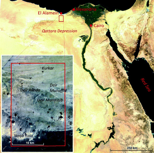
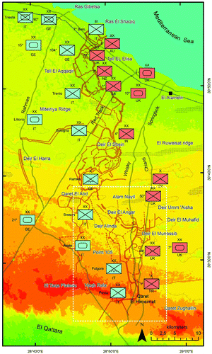
Figure 2. Military map of the El Alamein's battlefield before the third and final battle of El Alamein (23 October 1942). The white rectangle indicates the surveyed area. Red units belong to Allied Forces, blue units to Axis forces. Legend: IT, Italy; GE, Germany; UK, United Kingdom; IN, India; SA, South Africa; AU, Australia; NZ, New Zealand; FR, France; XX, Division; X, Brigade; II, Regiment; Crossed box, infantry unit; ellipse, armored unit; crossed box with wings, airborne unit; crossed box with ellipse, mechanized unit; Brown lines, minefields; gray lines, tracks; Green areas, low elevation; red areas, high elevation; Dotted area, main ridge.
2. Study area
The study area encompasses the southern sector of the El Alamein Battlefield (northwestern edge: 30°37′54″N, southeastern edge: 28°48′13″E), about 3600 km2, located roughly 100 km west of Alexandria.
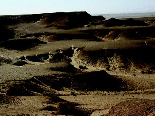
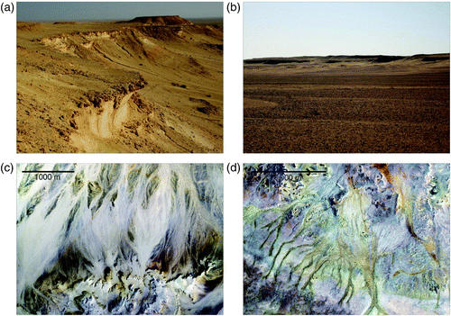
Coastal lagoons, known as sabkhas, characterized by evaporite-carbonate deposits occur in the northern sector of the study area, along the Mediterranean coast, where the development of a number of tourist resorts has severely altered the natural environment. Moving southward, a series of eight coast-parallel ridges, locally called kurkar, form a smooth undulated surface (CitationEmbabi, 2004). Their elevations range from tens to a hundred meters and may represent the palaeostructure of the Nile delta. Farther to the south, four main aeolian depressions (Deir El Qattara, Deir Alinda, Deir El Munassib, Deir El Munafid) and a number of minor ones are present. They are developed in east-west direction and the depth of the depressions range from a few meters up to 30 m. They have developed on a near horizontal structural surface and are carved mainly in limestone rocks. Southward, beyond a flat, horizontal carbonate plateau (Point 105 in the Main Map), a wadi-fan system is developed (bahada). The carbonate plateau is separated from the northern plateau by a 1–2 m scarp. Alluvial deposits are derived from at least seven limestone layers (El Taqa plateau), which are located in the southernmost sector of the study area. This area is characterized by mesas and cuestas () that decrease in elevation toward the El Qattara Depression, whose maximum depth is −165 m (CitationEmbabi, 2004).
Figure 3. Mesas and cuestas on the El Taqa Plateau, bordering the southern side of the battlefield. The escarpments are approximately 30 m high.
The geological background of the area is provided by the 1:250,000 Geological Map of Egypt, sheet n. 20 (CitationRushdi, 1990). The stratigraphic sequence occurring in the study area spans from Early Miocene to Pleistocene. The southern sector, at the border with the El Qattara Depression, is characterized by an Early Miocene clastic sequence with alternating sandstones, marlstones and limestone rocks (Moghra Formation; CitationEl-Barkooky et al., 2009). The Moghra Formation is represented on the map by terrigenous bedrock; when the sediments form a shallow cover on the rock surface, 1–2 m deep, they are shown as shallow terrigenous bedrock. In the central part of the map area, a Pliocene dolomitic carbonate sequence occurs (Marmarica Formation), while the kurkar area is characterized by Pliocene-Pleistocene limestones (El Hagif and Alessandria Formations; CitationRushdi, 1990; Stanley & Hamza, 1992). These two latter formations are reported either as carbonate bedrock or shallow carbonate bedrock, when covered by discontinuous and shallow debris deposits. The El Alamein battlefield is relatively flat, with horizontal or slightly inclined sedimentary bedrock. Relief is lower than 300 m and limited to the southern sector.
The arid and hyper arid climate is characterized by gentle and dry winters and dry and very hot summers. The hottest months are July and August. Temperatures range during the whole year from 0°C to 40°C. The southernmost sector of Western Desert is considered one of the driest regions of the world (CitationKehl & Bornkamm, 1993); here the decrease in rainfall is accompanied by increases in temperature and evapotranspiration in a North to South direction. Mean rainfall is 200 mm/year along the coast and decreases significantly in the Naqb Rala area (50 mm/year). Dominant winds are from the northwest.
3. Material and methods
Satellite image processing and photo-interpretation, regional DTM analysis and geomorphological field surveys were carried out in the Southern sector of the El Alamein battlefront. The terrain analyses has been performed using Google Earth imagery (SPOT, Geo-Eye-1 and Quickbird in the surveyed area), two Advanced Spaceborne Thermal Emission and Reflection Radiometer (ASTER) L1B scenes belonging to the same frame acquired on 10 October 2003 (resolution of 15 m/pixel and 30 m/pixel for VNIR and SWIR bands, respectively) and a DTM derived from the Shuttle Radar Topography Mission (SRTM-3) survey (90 m spatial resolution). The SRTM DTM has been studied using shaded relief, aspect and slope visualizations. ASTER imagery were orthorectified using the SRTM DTM and corrected both for the effects of cross-talk (signal leakage from ASTER band 4 into adjacent bands 5 and 9; CitationIwasaki & Tonooka, 2005) and atmosphere differential wavelength scattering. In particular, the atmospheric correction has been implemented converting the VNIR and SWIR bands from at-sensor radiance into surface reflectance using a desert areosol model in the ENVI-FLAASH module, which incorporates the MODTRAN4 radiation transfer code (CitationCooley et al., 2002). This correction enabled us to rely on ASTER data for relating different surface compositions with specific morphologies and/or diverse desert pavements. For example within the deir depressions, the silico-clastic Moghra Formation, at the base of the stratigraphic sequence, crops out surrounded by the younger carbonate series; hamada and serir spectral signatures are characterized by a different depth of the carbonate absorption peak (better defined in the hamada terrain as it is composed of large carbonate pebbles and boulders); flash floods deposits (bahadas) and wadi-fans are often well defined by a different spectral response with respect to surroundings areas.
For the interpretation of surface composition we favored the 7-3-1 Red Green Blue (RGB) color composites and the 2/1, 7/8 and 7/6 band ratios. This enabled us to highlight: (i) the Fe3+ absorption peak centerd at ASTER band 1 and the reddening effect typical of the desert varnish well developed at the surface of outcropping rocks of the Moghra Formation and serir pavements; (ii) the Al-OH absorption peak at ASTER band 6 which is typical of the clay minerals associated with the Moghra Formation and many deir floors, (iii) the absorption of the CO3 2− ion which is located at ASTER band 8 and shows a distinct behavior for the limestones and dolostones of the outcropping rocks and hamadas of the Plio-Pleistocene carbonate sequence (Marmarica, El Hagif and Alessandria Formations). In addition, a Principal Component Analysis has been also performed and the color composite RGB PC3-PC2-PC1 has been used for the evaluation of surface color variegation because the first three principal components load most of the variance of the original data-set.
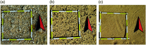
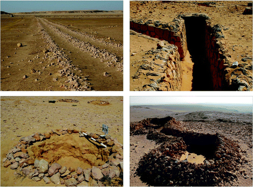
Remote sensing interpretation has been validated and refined through field surveying (). Thirty-five GCP (Ground Control Points) were collected using the following field protocol: (1) positioning a north-oriented 40 cm square, using a folding ruler; (2) photographing the desert surface (digital images, vertical close up and oblique views); (3) collecting sediment/rock sample and (4) global positioning system receiver coordinates.
Figure 4. North-oriented Ground Control Points showing the different surface characteristics: (a) hamada ground; (b) serir ground; (c) sandy ground.
The geomorphological map has been organized according to a morphogenetic classification of landforms. Deposits and landforms were organized according to the prevailing geomorphological process; in particular we considered fluvial, gravitational, aeolian and structural landforms.
4. Main landforms
4.1. Coastal ridges (kurkars)
Kurkars are well-developed on the coastal plain to the west of Alexandria. Their origin remains a matter of debate. A number of authors support a polygenetic origin (CitationButzer, 1960; El-Asmar, 1994a, Citation1994b, Citation2000; CitationShukri, Philip, & Said, 1956; CitationStanley & Hamza, 1992). Kurkars develop by wave action and local currents during transgressions. Shore processes created submerged parallel bars. During regressive phases, the submerged bars were subsequently exposed to subaerial processes, forming littoral bars through aeolian processes; subsequent pedogenesis and weathering processes contributed to their present form. Kurkar topography is characterized by slight discontinuous relief. Butzer (Citation1960), Shukri et al. (Citation1956) and CitationWali et al. (1994) suggest that the most ancient kurkars are Pleistocene in age, approximately 950 ka. Eight ridges occur, each separated by longitudinal depressions Citation(Butzer, 1960).
DEM (SRTM) data processing and the georeferencing of topographical maps at 1:250,000 and 1:100,000 served to highlight the occurrence of kurkars in the northern sector of the study area.
4.2. Deirs
Deir is a flat depression in a sub-horizontal rocky plateau. CitationEmbabi (2004) suggested that these depressions can be subdivided according to their size, ranging from centimeters to hundreds of kilometers. In particular, the author suggested that minor depressions represent the first step in the evolution of a deir, while the larger ones are the result of coalescence processes among several deirs ().
Figure 5. Examples of landforms in the study area: (a) escarpments at the front of the cuestas in Naqb Rala (El Taqa Plateau); (b) the floor of the Deir El Munassib Depression; peripheral scarps can be seen on the horizon; (c) wadi-fan system: the sediments are transported from South to North, forming coalescent cones; (d) network of wadis along the border of Point 105 (Quota 105).
Four major depressions have been recognized in the study area, up to 30 km in size: Deir El Munafid, Deir El Munassid, Deir Alinda, Deir El Angar.
Generally, deirs are covered by alluvial and aeolian deposits, while the surroundings are composed by rocky outcrops. Their genesis is mainly due to aeolian processes (CitationEmbabi, 2004) and subordinately by karstic solution and salt weathering.
4.3. Limestone structural surface
A broad exposure of Miocenic limestone crops out at Point 105. Slopes up to 5 m in height, border the southern and eastern front. The surface is cut by isolated wadis, from 10 to 50 meters in size and up to 3 meters deep. The contact with alluvial deposits and prominent cliffs is usually covered by rockfall, representing successive generations of gravitational collapses.
4.4. Wadi-fans
Wadi-fans are well developed in the study area. Because of the extreme aridity, the drainage pattern is formed by intermittent streams on alluvial fan surfaces and is composed of braiding or ephemeral channels. During intense rains the channels may be filled with sediments under turbulent flow (CitationFairbridge, 1968). Deposition in a wadi is rapid because of the sudden loss of stream velocity and seepage of water into the highly porous underlying sediments. As a result, wadi deposits are typically composed of poorly sorted gravels and sands. Subsequent to deposition, these sediments are commonly reworked by aeolian processes. Various wadi depositional morphologies, as ‘wadi fills’ or wadi fans, developed close to the slope, and bahadas (CitationMo'Awad, 2003) or ‘piedmont plains’ (CitationShata, 1971) have been found. The piedmont plains morphology are broad slopes of detrital alluvial outwash, usually composed of coalescing alluvial fans, whereas bahadas are aggradational features, formed during or immediately following flash floods.
In the study area, bahadas are mainly developed along south exposed slopes, toward El Qattara depression. Intense rainfall commonly creates temporary ponds or small lakes. Accumulation of fine sediments in these small lakes form layers of low infiltration and serve as confining layers above subsurface water-bearing units (CitationEmbabi, 2004).
4.5. Serir
Serirs are deflation surfaces formed by aeolian processes that winnow fines from the alluvial deposits. They act selectively, removing fine particles (silt and sand) while gravels, pebbles and heavy rocky fragments remain as a surface armor. This coarse sediment cover protects the underlying sediments and bedrock to the extent that no additional fines can be removed and the process ends. Pebbles are often covered by desert varnish.
4.6. Hamada
Hamada, or rocky plain surface, are associated with surfaces formed on the limestone plateau. A hamada is a desert plateau where deflation has removed the fine-grained surface materials and left behind a surface of sand-scoured bedrock with or without a veneer of pebbles or boulders (CitationGautier, 1935). This kind of morphology is mainly due to processes that remove smaller detritus, caused by wind action and precipitation. Consequently, large size detritus remains in situ, and are observed to blanket the landscape. In the study area hamadas are associated with rocky outcrops.
4.7. Military features
Because the study area is located within the southernmost sector of the El Alamein battlefield, physical remnants of military activity are found throughout the area. The defense system developed along the front is strongly influenced by topographical and geomorphological features, even the most minor element of relief is of critical importance in a desert war. Emplacements, such as foxholes, entrenchments, sangars (temporary fortified positions with a breastwork constructed of stones), artillery emplacements, depots, command posts, etc. () have been mapped. Emplacements are globally heterogeneous in shape, since their structure does not follow a particular plan. They consist mainly of several deep holes cut in the rock surface or Quaternary deposits, very often reinforced with low stonewalls. The connections between emplacements were made by a network of dirt roads or trails. The most important ones are reported in the Main map. The military emplacements are part of a hystorical GIS forming the framework of the El Alamein Project. About 1000, of 20,000, have been surveyed and photographed, some 300 have been dug and restored. All the geographical features have been related to historical maps and war journals in order to recognize the military units occupying the different sites. A military map of the El Alamein Battlefield will be published.
Figure 6. Examples of military remains along the Southernmost sector of the battlefield: (a) the Rommel Track (also known as Red Track), built by the British Army before the war; (b) the entrance to underground fortified chambers at Kaponga Box, which is a British fortress at Qaret El Abd; (c) an Italian foxhole at Point 105 (Quota 105); (d) an Italian observation post along the Southern front to El Qattara Depression.
5. Conclusions
The geomorphological map of the El Alamein Battlefield represents the first attempt to study this key-area in the history of WW2. The study of the geomorphological features and the surveying of military installations allowed us to map the main natural and anthropogenic morphological elements of the area. This work is part of wider military geography research on the El Alamein battlefield under the organization of the El Alamein Project (CitationBondesan, 2012). The geomorphological framework given by the map will form the fundamental basis for the reconstruction of the WW2 battlefield.
Software
All the image processing was performed using ENVI. Esri ArcGIS 10.0 was used for georeferencing, data-integration, mapping and editing of the final geomorphological map.
Main Map: Geomorphological Map of the El Alamein Battlefield (Southern Front) Western Desert, Egypt
Download PDF (12.5 MB)Acknowledgements
This research is part of the El Alamein Project, which aims to reconstruct and protect the El Alamein battlefield. It is partially financed by MIUR funds of Aldino Bondesan (ex 60%, 2009-2010-2011).
Additional information
Notes on contributors
Aldino Bondesan
Secondary Author(s): Franco Coren, Lamberto Fabbrucci, Nicola PetrellaReferences
- Bondesan , A. 2012 . “ Between history and geography. The El Alamein project: Research, findings, and results ” . In The battles of El-Alamein and the struggle for North Africa, 1940–1943 , Edited by: Edwards , J. 113 – 136 . Cairo : AUC .
- Butzer , K. W. 1960 . On the Pleistocene shorelines of the Arab's Gulf, Egypt . The Journal of Geology , 68 : 626 – 637 . (doi:10.1086/626701)
- Cooley , T. , Anderson , G. P. , Felde , G. W. , Hoke , M. L. , Ratkowski , A. J. , Chetwynd , J. H. , Gardner , J. A. , Adler-Golden , S. M. , Matthew , M. W. , Berk , A. , Bernstein , L. S. , Acharya , P. K. , Miller , D. and Lewis , P. 2002 . Geoscience and remote sensing, symposium . IEEE International Geoscience and Remote Sensing Symposium , 02 ( 3 ) : 1414 – 1418 . (doi:10.1109/IGARSS.2002.1026134)
- El-Asmar , H. M. 1994a . Aeolianite sedimentation along the northwester coast of Egypt: Evidence for middle too late quaternary aridity . Quaternary Science Reviews , 13 : 699 – 708 . (doi:10.1016/0277-3791(94)90100-7)
- El-Asmar , H. M. 1994b . Recognition of diagenetic environments of the Pleistocene carbonate rocks at el Hammam, NW Mediterranean coast of Egypt using stable isotopes and electron microprobe . Neues Jahrbuch für Geologie und Paläontologie Monatshefte , 1 : 7 – 22 .
- El-Asmar , H. M. 2000 . Quaternary shoreline development: The northwestern coast of Egypt . Quaternary Science Reviews , 19 : 1137 – 1149 . (doi:10.1016/S0277-3791(99)00097-9)
- El-Barkooky, A., Hamdan, M., Hassan, S. M., Christie-Blick, N., Goldstein, S., & Cai, Y. (2009). Sequence stratigraphy of the lower miocene moghra formation in the qattara depression, Northwestern desert, Egypt. AAPG annual convention, Denver, Colorado, June 7–10, 2009.
- Embabi, N. S. (2004). The geomorphology of Egypt. Landforms and evolution, Volume I, The Nile Valley and the Western Desert. The Egyptian Geographical Society Special Publication, Cairo, 447.
- Fairbridge, R. W. (1968). The encyclopedia of geomorphology. Encyclopedia of earth sciences Series, Vol. III. Dowden, Hutchinson & Ross, Inc., Stroudsburg, Pennsylvania, 1295.
- Gautier , E. F. 1935 . Sahara, the great desert , 264 New York : Columbia University Press .
- Iwasaki , A. and Tonooka , H. 2005 . Validation of crosstalk correction algorithm for ASTER/SWIR . IEEE Transactions on Geoscience and Remote Sensing , 43 ( 12 ) : 2747 – 2751 . (doi:10.1109/TGRS.2005.855066)
- Kehl , H. and Bornkamm , X. 1993 . “ Landscape ecology and vegetation units of the Western Desert of Egypt ” . In Geopotential ecology analysis of a desert region Edited by: Meisser , B. and Wycisk , P. (Vol. 26, pp. 407–438).
- Mo'Awad, M. B. (2003). The geomorphology of coastal zone between Ras Abu Girab and Ras ‘Alam El-Roum, The NW coast of Egypt, Unpublished M. Sc., Departament of Geography, Faculty of Arts, Aim Shams University, Cairo, 279.
- Parson , A. J. and Abrahams , A. D. 2009 . Geomorphology of desert environments , Springer .
- Rushdi, S. (1990). The geology of Egypt. Egyptian general petroleum corporation, Conoco Hurgada Inc. and Respol Exploration, Rotterdam, 734.
- Shata, A. (1971). The geomorphology, pedology and hydro-geology of the Mediterranean coastal desert of UAR, in geology of Libya (Editor: C. Gray), proc. Symposium on the Geology of Libya, Tripoli, April, 14–19, 1969, University of Libya, Tripoli, 346–431.
- Shukri , N. M. , Philip , G. and Said , R. 1956 . The geology of the Mediterranean coast between Rosetta and Bardia, II Pleistocene sediments: Geomorphology and microfacies . Bull. Institute d’ègypte , 37 : 395 – 427 .
- Stanley , D. J. and Hamza , F. H. 1992 . Terrigenous – carbonates sediment interface (Late-Quaternary) along the northwestern margin of the Nile Delta, Egypt . Journal of Coastal Research , 8 : 153 – 171 .
- Wali, A. M. A., Brookfield, M. E., Schreiber, B. C. (1994). The depositional and diagenetic evolution of the coastal ridges of northwestern Egypt. Sedimentary Geology, 90, 113–136.