Abstract
The study area is located across the Chianti Ridge (Tuscany, Italy), between the Upper Valdarno Basin and the Siena Basin. This area covers about 25 km2, forming a narrow belt oriented N–S and drained by the Ambra and Ombrone creeks, which flow northward and southward, respectively. Field mapping was carried out at 1:10,000 scale through an allostratigraphic-sedimentological approach. The study area deposits represent the infill of a SW-draining paleovalley, cut both in pre-Neogene bedrock and marine Pliocene deposits of the Siena Basin. The valley-fill succession consists of two main allounits (V1 and V2), which are conformably stacked in the northern sector of the study area, and unconformably offset in the southern sector. V1 comprises gravelly to sandy fluvial deposits, whereas V2 deposits show noticeable downvalley variability. V2 consists of poorly drained floodplain deposits in the northern sector of the paleovalley, whereas gravel and sand-bed river deposits fill its southern part. Alluvial-fan and palustrine deposits are also associated with V2 fluvial facies. A normal fault trending NW–SE is the main structural feature of the area. This fault cuts the V2 unit lowering the upstream reach and is thought to have promoted the marked facies changes observed in the fluvial deposits of unit V2.
1. Introduction
The study area (), located on the northern margin of the Siena Basin (Tuscany, Italy), has been the target of geological studies since the beginning of the 1980s. Specifically, CitationCostantini, Lazzarotto, and Sandrelli (1982) focused on the deposits exposed in the southern part of the study area in the framework of their relationship with the Pliocene Siena Basin, whose alluvial nature was firstly recognized by CitationMagi (1992). Furthermore, the geomorphological features of the Ambra Valley and its relationships with the Pleistocene depositional evolution of the Upper Valdarno Basin () were discussed by CitationCostantini, Mazzanti, and Sandrelli (1995). More recently, CitationAldinucci, Ghinassi, and Sandrelli (2007) interpreted the alluvial deposits cropping out in the southern part of the study area as the Plio–Pleistocene infill of an incised-valley. This interpretation was also reported by CitationLazzarotto, Costantini, Sandrelli, Brogi and Foresi (in press) in the framework of the geological mapping project of Carta Geologica d'Italia (Foglio 297-Asciano. ISPRA).
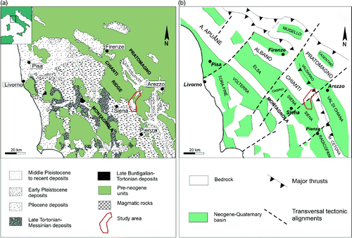
Figure 1. Northern Apennines. (a) Geological sketch map of Tuscany and (b) Schematic structural map of the area shown in a.
Although increasing attention has been paid to the alluvial post-Middle Pliocene deposits of this area, their spatial distribution and internal architecture is still poorly known, as well as their sedimentary history.
The present study was carried out through detailed field mapping, using sedimentological and allostratigraphic principles, in order to refine the stratigraphy of the Pliocene – Pleistocene deposits exposed along the north-eastern margin of the Siena Basin. This work also aims to clarify the relationship between tectonic activity and the sedimentary evolution of the northern Siena Basin during the Pliocene-Pleistocene time span.
The study area is located in central Tuscany (about 70 km south of Florence), between the Upper Valdarno Basin and the Siena Basin ( and ). It represents a N-S-oriented belt along the so-called ‘Arbia-Val Marecchia line’ (one of the main tectonic transverse lineaments of the Northern Apennines, CitationLiotta, 1991; CitationPascucci, Martini, Sagri, & Sandrelli, 2007), and extends from the north-eastern margin of the Siena Basin into the Chianti Ridge () Citation(Brogi, 2011). The northern and southern parts of this area are presently drained by the Ambra and Ombrone creeks, respectively. Specifically, the Ambra Creek flows northward, towards the Upper Valdarno Basin, whereas the Ombrone Creek drains southward and belongs to the catchment of the Siena Basin ().
2. Geological setting
The Northern Apennines are a Tertiary fold-and-thrust belt resulting from the interaction between the Adria and Corsica–Sardinian microplates, within the framework of the larger-scale collision of Africa with Eurasia Citation(Carmignani et al., 2001 and references therein). The Northern Apennines tectonic pile consists of several stacked tectonic units representing different paleogeographical zones, ranging from western (internal) oceanic areas (Ligurian units) to eastern continental domains (Tuscan and Umbria-Marche units), with an intervening area of transitional crust (Subligurides units). The geological history of the Northern Apennines reflects a compressional-extensional orogenic cycle Citation(Barchi, 2010; CitationBrogi, 2008; CitationCarmignani et al., 1994, Citation1995; CitationElter, Giglia, Tongiorgi, & Trevisan, 1975; CitationLiotta, Cernobori, & Nicolich, 1998), with compression dating back to the Late Cretaceous – Paleocene and following the closure of the Ligurian–Piedmont Ocean in the inner Northern Apennines (i.e. southern Tuscany). The extensional tectonics started in the Early (Tyrrhenian area, CitationCarmignani et al., 1995) – Middle (southern Tuscany, CitationBrogi & Liotta, 2008) Miocene and coexisted with the compressional tectonics in the outer Northern Apennines. These extensional tectonics gave rise to detachment basins, which were successively dissected by high-angle normal faults showing listric geometries (CitationBrogi, 2008, Citation2011; CitationBrogi, Lazzarotto, Liotta, & Ranalli, 2003; CitationDallmeyer & Liotta, 1998) and leading to the modern ‘horst and graben’ configuration (). This extensional basin pattern was described in detail by CitationMartini and Sagri (1993). These authors distinguished between ‘peripheral’ and ‘central’ basins, which were located close to the Apenninic divide and the Tyrrhenian Sea, respectively. The central basins were filled by upper Miocene – Middle Pliocene deposits, whereas the peripheral ones experienced a Pliocene – Pleistocene continental sedimentation.
Neogene – Quaternary basins () are separated by bedrock ridges trending NW–SE (e.g. Chianti Ridge) and transversal lineaments trending NE–SW (e.g. so called ‘Arbia-Val Marecchia line’; CitationLiotta, 1991; CitationPascucci et al., 2007). Although their origin is still debated, transversal lineaments are thought to represent the link between areas with different rate of extension and shortening Citation(Castellarin, Eva, Giglia, & Vai, 1986; CitationLiotta, 1991; CitationPascucci, Martini, Sagri, & Sandrelli, 2007).
The fill of the Upper Valdarno Basin (‘peripheral’ basin) comprises fluvio-lacustrine deposits up to 550 m thick, subdivided into four main unconformity-bounded stratigraphic units Citation(Fidolini, Ghinassi, Magi, Papini, & Sagri, 2013; CitationGhinassi, Fidolini, Magi, & Sagri, 2013). The Siena Basin (‘central’ basin) Citation(Brogi, 2011) was filled with about 1000 m of Miocene continental deposits unconformably overlain by about 600 m of Pliocene alluvial to shallow marine deposits Citation(Costantini et al., 1982; CitationMartini, Aldinucci, Foresi, Mazzei, & Sandrelli, 2011; CitationMartini et al., 2013). The stratigraphic architecture of Pliocene deposits is relatively poorly known, except for some areas, recently investigated according to allostratigraphic and sequence-stratigraphic principles Citation(Arragoni, Martini, & Sandrelli, 2012; CitationMartini et al., 2011, Citation2013). Specifically, according to CitationMartini et al. (2011) the Pliocene deposits of the northern basin margin (alluvial-to-inner shelf marine sediments) are organized in four allostratigraphic units. Marine sedimentation ended in the latest Piacenzian, when an overall uplift of southern Tuscany resulted in subaerial exposure and sedimentation of Pleistocene alluvial deposits Citation(Costantini et al., 1982; CitationMartini & Sagri, 1993).
3. Methods
The present work provides a high-resolution map (1:20,000) covering about 25 km2 (see Main map), from the area of Capannole village to the neighbourhood of Rapolano Terme village, and focuses on the continental deposits accumulated from the earliest Late Pliocene (Piacenzian) to the Middle Pleistocene (Ionian). Field mapping was performed at 1:10,000 scale using the ‘Carta Tecnica Regionale’ topographic map (sections: 287080, 287120, 287150, 287160, 288050, 288090, 288130, 297030, 297040, 297070, 297080, 297110 and 297120).
Field mapping was carried out through an allostratigraphic-sedimentological approach, based on facies analysis principles. The mapped deposits represent different sedimentary environments (i.e. facies associations) that were subdivided into allounits, namely stratigraphic units bounded by both unconformities and correlative-conformity surfaces Citation(North American Commission on Stratigraphic Nomenclature, 1983). Facies association mapping was adopted since it is a powerful tool to define depositional history and basin-scale geometry of sedimentary successions Citation(Arragoni et al., 2012; CitationGhinassi, Libsekal, Papini, & Rook, 2009; CitationMartini et al., 2011, Citation2013). Allounits are preferred to depositional sequences Citation(Vail, Mitchum, & Thompson, 1977), UBSU Citation(Salvador, 1987) or synthems (CitationChang, 1975; CitationInternational Subcommission on Stratigraphic Classification, 1987; CitationSalvador, 1994) because of their wide applicability in narrow confined basins characterized by erosional, non–depositional and correlative-conformity surfaces, either in marginal or depocentral areas.
4. Stratigraphy
The studied deposits overlie unconsolidated, alluvial to shallow-marine Zanclean to Piacenzian sediments of the Siena Basin and pre-Neogene bedrock (i.e. Ligurian, Subligurian and Tuscan units).
4.1 Pre-Neogene bedrock
Ligurian units are represented by siliciclastic (Santa Fiora Fm., Cretaceous–Paleocene) and calcareous (Mt. Morello Fm., Eocene) turbiditic deposits Citation(Abbate & Sagri, 1982; CitationAbbate et al., 1986; CitationBoccaletti et al., 1990; CitationLazzarotto et al., in press). The Santa Fiora Formation is made of grayish mud-siltstone strata intercalated by limestone and fine calcarenitic. The Monte Morello Formation is composed of grayish to brownish limestone and marl-limestone strata, with intercalations of marl and calcarenites layers.
Subligurian units are characterized by turbiditic deposits of the Paleocene–Eocene Argille e Calcari di Canetolo Fm. Citation(Bruni, Cipriani, Nebbiai, & Papini, 2007) and Oligocene Arenarie di Mt. Senario Fm. (CitationLazzarotto et al., in press). The first formation is constituted by grayish to brownish mud-siltstone strata interbedded with grayish calcarenites and sandstone. The second formation consists of yellowish coarse sandstone strata intercalated with conglomeratic-sandstone intervals and thin argillite layers.
The Tuscan Units are represented solely by the Macigno Fm. (Chattian– Aquitanian), consisting of thick strata of turbiditic sandstone with mudstone intercalations. At the base of the formation several layers of calcarenites can occur Citation(Cornamusini, Ielpi, Bonciani, Callegari, & Conti, 2012).
4.2 Zanclean-Piacenzian deposits (Siena basin)
The Pliocene (Zanclean–Piacenzian) alluvial to shallow-marine deposits are organized into four allostratigraphic units Citation(Martini et al., 2011), which are grouped under a single label within the present study.
The Pliocene succession consists of alluvial deposits Citation(De Castro & Pilotti, 1933; CitationManganelli, Aldinucci, Capezzuoli, & Benocci, 2007; CitationManganelli, Martini, & Benocci, 2011; CitationMartini et al., 2011), passing upward into nearshore (deltaic-non deltaic) deposits often rich in molluscan assemblages Citation(Manganelli, Spadini, & Martini, 2010).
4.3 Gelasian–Calabrian deposits (Valley fill)
The examined succession comprises two allounits (V1 and V2) and represents the infill of a U-shaped elongate depression that was cut both in the bedrock and Pliocene deposits. For sake of clarity, the description of the study area will focus on two sectors: North of Castello di Montalto and South of Castello di Montalto (see Main map). In the southern sector V1 and V2 are erosionally stacked one upon the other although the bodies' axis are not aligned vertically, whereas in the northern sector these allounits are conformably stacked. V1 comprises mainly gravelly deposits and rare mud, whereas V2 consists of sand and mud with subordinate gravel. Field evidence and well-core data show that allounits V1 and V2 are at least 60 and 25 m thick, respectively.
Paleocurrent measurements from both these units show that the main transport direction was toward SW (i.e. toward the Siena Basin).
4.3.1 Allounit V1
Allounit V1 crops out in the southern sector, but has also been identified in the northern sector through well-core data. It is composed of alternating intervals of gravel, sand and subordinate mud, showing a well-defined fining-upward trend (). The gravelly intervals consist of amalgamated channelized bodies with minor intercalations of lens–shape gravelly sand (). Gravel is clast-supported, poorly sorted and locally contains abundant sandy matrix. Clasts are rounded and some of them show abraded litophaga traces, highlighting the reworking from Pliocene marine deposits below.
Figure 2. Stratigraphy of the study area alluvial deposits. (a) Pliocene continental deposits unconformably overlain by allounit V1, which shows three main fining upward (FU) intervals, the main unconformity is marked by a yellow line; (b) Fining-upward fluvial gravel of unit V2flb, unconformably overlaying Pliocene marine deposits; and (c) Sandy fluvial deposits of unit V2flb deposits, covered by palustrine V2pl facies and overlain Pliocene marine deposits.
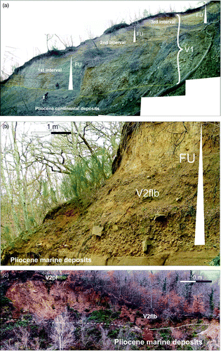
Figure 3. Sedimentary facies of the study area deposits. (a) fluvial sand with subordinate silt of V1; (b) fluvial gravels with abundant sandy matrix (V1); (c) muddy floodplain deposits of V2fla; (d) fluvial, cross-stratified gravel of V2flb unit; (e) organic-rich deposits of V2pl palustrine deposits; and (f) alluvial-fan gravel of unit V2af.
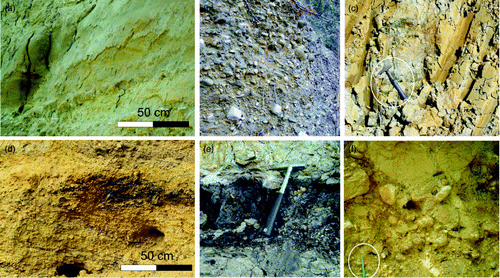
The sandy to muddy intervals ( and ) are characterized by strong pedogenesis, with organic-rich mud horizons and scattered continental gastropods (Pomatia elegans and Retinella sp; CitationAldinucci et al., 2007). All these fine-grained intervals disappear moving northward, making the gravelly intervals amalgamate.
The basal gravelly part of each interval is interpreted as fluvial bars of a gravel-bed river system Citation(Bridge & Lunt, 2006; CitationLunt & Bridge, 2004; CitationLunt, Bridge, & Tye, 2004), whereas the muddy to sandy deposits represent a floodplain environment Citation(Bridge, 2003; CitationJones, Frostick, & Astin, 2001; CitationReading, 1996). Continental gastropods suggest these deposits are younger than Piacenzian.
4.3.2 Allounit V2
Allounit V2 consists of a wide spectrum of deposits with different stacking patterns North and South of Castello di Montalto (see Main map).
North of Castello di Montalto, allounit V2 (up to 25 m thick) is dominated by massive, brownish to grayish silt-grained pedogenized deposits characterized by plant remains, roots and organic-enriched layers (V2fla; ). Isolated and rare sandy deposits occur as lens-shaped bodies, floored by gravel-rich coarse sand. These deposits are ascribed to a poorly drained floodplain environment (V2fla) Citation(Bridge, 2003; CitationMiall, 1996; CitationJones et al., 2001; CitationNemec, 1996).
South of the Castello di Montalto, allounit V2 is composed of 15 m thick, channelized and cross-stratified gravel (V2flb; and ), passing downstream into channelized trough cross–stratified gravelly sand (V2flb; ). Both these units are covered by organic-rich mud (V2pl; ), which is up to 8 m thick and contains abundant freshwater gastropods (e.g. Bithynia tentaculata). The gravelly deposits are interpreted as fluvial bars within a gravel bed river setting Citation(Bridge & Lunt, 2006; CitationLunt & Bridge, 2004; CitationLunt et al., 2004), with the sandy ones as fluvial bars of a sand-bed river system Citation(Bridge, 2003; CitationSmith 1986; CitationThorne et al., 1985). The overlying muddy interval accumulated in a palustrine setting Citation(Esu, Girotti, & Kotsakis, 1993; CitationMiall, 1996; CitationNemec, 1996).
Gravelly fan-shape deposits (V2af) occur along the flanks of the U-shape depression both in the northern and southern sector. These bodies mainly comprise channelized gravelly deposits () that pass downstream into poorly channelized gravelly sand and show a paleotransport direction transverse to the belt axis, as defined by V2 deposits. The V2af deposits are attributed to an alluvial fan setting Citation(Nemec & Muszynski, 1982; CitationNemec & Steel, 1984; CitationSohn, Rhee, & Kim, 1999).
To the North, the alluvial fan deposits are heteropic with V2fla fluvial deposits, whereas to the South they are heteropic both with V2flb fluvial deposits and palustrine deposits (V2pl). The Calabrian age of this unit is inferred from the occurrence of Aculean stonetools in distal alluvial fan facies Citation(Magi, 1992).
According to their geometries and sedimentological features, units V1 and V2 are interpreted as the infill of two paleovalleys that were nested in the northern sector of the study area, and offset in the southern part. The paleovalleys system was drained toward the SW (units V1 and V2fla-b) and it received sediments from alluvial fans developed along valley flanks (V2af).
4.4 Ionian deposits (alluvial terraces)
Fluvial terraces of the Ambra and Ombrone creeks are easily distinguished in the present-day topography. They are made of sandy bodies capped by pedogenized mud and occur along the flanks of the modern valley, showing an erosional base and flat top. The Ambra and Ombrone drainages developed two and one order of terraces, respectively.
5. Structural features
Several tectonic lineaments have been recognized in the selected area, and ascribed both to thrusts and high-angle normal faults (CitationLazzarotto et al., in press). Thrusts separate Ligurian from Tuscan units and show a NE vergence resulting from the Late Cretaceous-Late Eocene compressional phase Citation(Martini & Sagri, 1993). High-angle normal faults have a dominant ‘Apenninic’ NW–SE trend and are associated with the post-collisional, extensional tectonic phase (Plio-Quaternary, CitationBrogi, Liotta, Lazzarotto, & CROP18 working group, 2005).
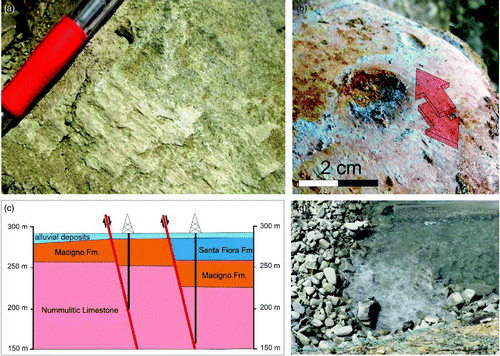
The most significant tectonic lineament of the area occurs near Castello di Montalto (), and shows a NW-SE trend (i.e. normal to valley axis). Structural stations, measured along this lineament, show a 120° N trend and 30° N dip, with an overall normal movement, lowering the northern area (i.e. upstream valley sector). Field and well-core data () show a differential bedrock displacement, measured on Macigno Fm. outcrops, which increases from 40 to 60 m moving eastward along the fault. This fault displaces V1 deposits, which bear evidence of tectonic deformations (i.e. striation; ). The variability of fluvial deposits of unit V2 (V2fla and flb) across the fault zone could testify a syn-depositional tectonic sedimentation. The present-day intense CO2 emission () indicates potential active tectonics, or, at least, a hydrothermalism as the last stage of recent activity. Activity of this fault is consistent with the latest stage of Siena Basin evolution Citation(Brogi, 2011), characterized by activation of high-angle normal faults after a phase of crustal detachments.
Figure 4. Structural features of the normal fault crossing the study area paleovalley. (a) Fault plane in sandstone (Macigno Fm.) and related kinematic indicators consisting of superposed generations of calcite fibers; (b) Tectonic striations (red arrow) caused by intra-clast shearing induced by tectonic displacement; (c) Well-core data showing bedrock displacement affected by the fault in the Castello di Montalto area; and (d) Natural CO2 emissions along the Ambra Creek.
6. Conclusions
This work provides a high-resolution geological map of the Pliocene and Pleistocene deposits exposed along northern margin of the Siena Basin through an allostratigraphic and sedimentological approach. The study deposits represent the infill of a SW-draining paleovalley, and consist of two main allounits, V1 and V2. These allounits are conformably stacked in the northern sector of the study area and unconformably offset in the southern sector. V1 mainly consists of gravelly fluvial deposits, whereas V2 deposits show a marked downvalley variability, manifested by poorly drained floodplain deposits (V2fla) in the northern sector, and by gravel-bed river deposits (V2flb) in the southern one. Alluvial fan (V2af) and palustrine (V2pl) deposits are associated with V2 fluvial facies. A NW–SE trending normal fault cuts transversally the paleovalley axis near Castello di Montalto. This fault displaces V1 deposits and is probably the cause of the along–valley variability of V2fl deposits.
Software
Hand-drawn originals have been scanned and redrawn in Corel-Draw Graphic Suite X3.
Main Map: Geological Map of the Pliocene-Pleitocene Deposits of Ambra and Ombrone Valleys: (Northern Siena Basin, Tuscany, Italy)
Download PDF (11.3 MB)Acknowledgments
This work derives from PhD (V.B.) and MSc (N.B., G.M. and M.R.) theses which were supervised by MG. Fieldwork was supported by the University of Padova (Fondi di Ateneo ex 60%, 2009 and 2010 – M. Ghinassi). Katarina Gobo (University of Bergen) improved an earlier version of the manuscript. Dr. A. Brogi (University of Bari), Dr. V. Özaksoy (Akdeniz University) and Dr. Amy Griffin (University of NSW) reviewed the manuscript and are kindly thanked for their constructive comments.
Related Research Data
References
- Abbate , E. , Bortolotti , V. , Conti , M. , Marcucci , M. , Principi , G. , Passerini , P. and Treves , B. 1986 . Apennines and Alps ophiolites and the evolution of the Western Tethys . Memorie Societa’ Geologica Italiana , 31 : 23 – 44 .
- Abbate , E. and Sagri , M. 1982 . Le unità torbiditiche cretacee dell'Appennino settentrio-nale ed i margini continentali della Tetide . Memorie Societa’ Geologica Italiana , 24 : 115 – 126 .
- Aldinucci , M. , Ghinassi , M. and Sandrelli , F. 2007 . Climatic and tectonic signature in the fluvial infill of a late Pliocene valley (Siena Basin, Northern apennines, Italy) . Journal of Sedimentary Research , 77 : 398 – 414 .
- Arragoni , S. , Martini , I. and Sandrelli , F. 2012 . Facies association map of the Pliocene deposits of the central-southern Siena Basin (Tuscany, Italy) . Journal of Maps , 8 ( 4 ) : 406 – 412 . doi: 10.1080/17445647.2012.744706
- Barchi, M. (2010). The Neogene-Quaternary evolution of the Northern Apennines: Crustal structure, style of deformation and seismicity. In M. Beltrando, A. Peccerillo, M. Mattei, S. Conticelli, & C. Doglioni (Eds.), The Geology of Italy: Tectonics and life along plate margins, Journal of the Virtual Explorer, 36, paper 11. doi:10.3809/jvirtex.2010.00220
- Boccaletti , M. , Ciaranfi , N. , Cosentino , D. , Deiana , G. , Gelati , R. , Lentini , F. , Massari , F. , Moratti , G. , Pescatore , T. , Ricci Lucchi , F. and Tortorici , L. 1990 . Palinspastic restoration and paleogeographic reconstruction of the Peri-Thyrrhenian area during Neogene . Paleogeography. Paleoclimatology. Paleoecolology , 77 : 41 – 50 .
- Bridge , J. S. 2003 . Rivers and floodplains , Malden , Mass : Blackwell Publishing . (p. 491)
- Bridge , J. S. and Lunt , I. A. 2006 . “ Depositional models in braided rivers ” . In Braided rivers: Process, deposits, ecology and management , Edited by: Sambrook Smith , G. H. , Best , J. L. , Bristow , C. S. and Petts , G. E. Vol. 36 , 11 – 50 . IAS special publication .
- Brogi , A. 2008 . The Triassic and Palaeozoic successions drilled in the Bagnore Geothermal field and Poggio Nibbio area (Monte Amiata, Northern apennines, Italy) . Bollettino Società Geologica Italiana , 3 : 599 – 613 .
- Brogi , A. 2011 . Bowl-shaped basin related to low-angle detachment during continental extension: The case of the controversial Neogene Siena Basin (central Italy, Northern apennines) . Tectonophysics , 499 : 54 – 76 .
- Brogi , A. , Lazzarotto , A. , Liotta , D. and Ranalli , G. 2003 . Extensional shear zones as imaged by reflection seismic lines: The Larderello geothermal field (central Italy) . Tectonophysics , 363 : 127 – 139 .
- Brogi , A. and Liotta , D. 2008 . Highly extended terrains, lateral segmentation of the substratum and basin development: The Middle-Late Miocene Radicondoli Basin (Inner Northern apennines, Italy) . Tectonics , 27 : 1 – 20 . TC 5002. doi: 10.1029/2007TC002188
- Brogi , A. , Liotta , D. , Lazzarotto , A. and CROP18 working group . 2005 . Structural features of southern Tuscany and geological interpretation of the CROP18 seismic reflection seismic survey (Italy) . Bollettino Società Geologica Italiana , Spec. 3 : 213 – 236 .
- Bruni , P. , Cipriani , N. , Nebbiai , M. and Papini , M. 2007 . Dati litostratigrafici e petrografici delle arenarie silicoclastiche del complesso di Canetolo affiorante tra le Cinque Terre e la Val di Magra (Paleocene-Oligocene sup., Appennino Settentrionale) . Bollettino della Societa Geologica Italiana , 126 : 557 – 565 .
- Carmignani , L. , Decandia , F. A. , Disperati , L. , Fantozzi , P. F. , Kligfield , R. , Lazzarotto , A. , Liotta , D. and Meccheri , M. 2001 . “ Inner Northern apennines ” . In Anatomy of an orogene. The apennines and adjacent mediterranean basins , Edited by: Vai , G. B. and Martini , I. P. 197 – 214 . Dordrecht, The Netherlands .
- Carmignani , L. , Decandia , F. A. , Disperati , L. , Fantozzi , P. L. , Lazzarotto , A. , Liotta , D. and Oggiano , G. 1995 . Relationships between the tertiary structural evolution of the Sardinia-Corsica-Provencal domain and the Northern apennines . Terra Nova , 7 ( 2 ) : 128 – 137 .
- Carmignani , L. , Decandia , F. A. , Fantozzi , P. L. , Lazzarotto , A. , Liotta , D. and Meccheri , M. 1994 . Tertiary extensional tectonics in Tuscany (Northern apennines, Italy) . Tectonophysics , 238 : 295 – 315 .
- Castellarin , A. , Eva , C. , Giglia , G. and Vai , G. B. 1986 . Analisi strutturale del fronte Appenninico padano . Giornale di Geologia , 47 : 47 – 76 .
- Chang , K. H. 1975 . Unconformity bounded stratigraphic units . Geological Society American Bulletin , 86 : 1544 – 1552 .
- Cornamusini , G. , Ielpi , A. , Bonciani , F. , Callegari , I. and Conti , P. 2012 . Geological map of the Chianti Mts (Northern apennines, Italy) . Journal of Maps , 8 ( 1 ) : 22 – 32 .
- Costantini , A. , Lazzarotto , A. and Sandrelli , S. 1982 . Conoscenze geologico- strutturali in: il Graben di Siena . CNR-PFE-RF , 9 : 11 – 33 .
- Costantini , A. , Mazzanti , R. and Sandrelli , F. 1995 . La val d'Ambra, appendice del lago superiore del Valdarno Superiore nel Pleistocene medio e attuale punto di contatto incerto nello spartiacque tra i bacini dell'Arno e dell'Ombrone . Atti Società toscana Scienze Naturali, Memorie, Serie A , 102 : 177 – 184 .
- Dallmeyer , R. D. and Liotta , D. 1998 . Extension, uplift of rocks and cooling ages in thinned crustal provinces: The Larderello geothermal area (inner Northern apennines, Italy) . Geological Magazine , 135 ( 2 ) : 193 – 202 .
- De Castro , C. and Pilotti , C. 1933 . I giacimenti di lignite della Toscana , Italy : Roma . (p. 224)
- Elter , P. , Giglia , G. , Tongiorgi , M. and Trevisan , L. 1975 . Tensional and compressional areas in the recent (Tortonian to present) evolution of the Northern apennines . Bollettino di Geofisica teorica e Applicata , 17 : 3 – 18 .
- Esu , D. , Girotti , O. and Kotsakis , T. 1993 . Palaeobiogeographical observations on Villafranchian continental molluscs of Italy . Scripta Geologica , 2 : 101 – 119 .
- Fidolini , F. , Ghinassi , M. , Magi , M. , Papini , M. and Sagri , M. 2013 . The Plio-Pleistocene upper Valdarno basin (central Italy): Stratigraphy and basin fill evolution . Italian Journal of Geosciences , 132 : 13 – 32 .
- Ghinassi , M. , Fidolini , F. , Magi , M. and Sagri , M. 2013 . Facies analysis and depositional environments of the Plio-Pleistocene upper Valdarno basin (Tuscany, Italy) . Italian Journal of Geosciences , 132 : 33 – 53 .
- Ghinassi , M. , Libsekal , Y. , Papini , M. and Rook , L. 2009 . Palaeoenvironments of the Buia Homo site: High-resolution facies analysis and non-marine sequence stratigraphy in the Alat formation (Pleistocene Dandiero Basin, Danakil depression, Eritrea) . Palaeogeography, Palaeoclimatology, Palaeoecology , 280 : 415 – 431 .
- International Subcommission on Stratigraphic Classification . 1987 . Unconformity bounded stratigraphic units . Geological Society American Bulletin , 98 : 232 – 237 .
- Jones , S. J. , Frostick , L. E. and Astin , T. R. 2001 . Braided stream and flood plain architecture: The Rio Vero Formation . Spanish Pyrenees: Sedimentary Geology , 139 : 229 – 260 .
- Lazzarotto , A. , Costantini , A. , Sandrelli , F. , Brogi , A. and Foresi , M. L. in press . Carta Geologica d'Italia alla Scala 1:50.000, Foglio 297-Asciano , ISPRA, Servizio Geologico d'Italia, Roma .
- Liotta , D. 1991 . The Arbia-Val Marecchia Line, Northern apennines . Eclogae geologicae Helveticae , 84/2 : 413 – 430 .
- Liotta , D. , Cernobori , L. and Nicolich , R. 1998 . Restricted rifting and its coex-istence with compressional structures: Results from the CROP03 traverse (Northern apennines, Italy) . Terra Nova , 10 : 16 – 20 .
- Lunt , I. A. and Bridge , J. S. 2004 . Evolution and deposits of a gravelly braid bar, Sagavanirktok River, Alaska . Sedimentology , 51 : 415 – 432 .
- Lunt , I. A. , Bridge , J. S. and Tye , R. S. 2004 . A quantitative, three-dimensional depositional model of gravelly braided rivers . Sedimentology , 51 : 377 – 414 .
- Magi, M. (1992). Depositi fluviali e di conoidi alluvionali del Pleistocene nell'alta Valle dell'Ombrone (Siena). Società Geologica Italiana, 76° Riunione Estiva, Riassunti, 183 pp.
- Manganelli , G. , Aldinucci , M. , Capezzuoli , E. and Benocci , A. 2007 . Strobilopsid land snails (Gastropoda: Polmonata, Strobilopsidae) from late Messinian-early Pliocene (?) of Balze di Caspreno (central Italy) . Bollettino della Società Paleontologica Italiana , 46 : 101 – 106 .
- Manganelli , G. , Martini , I. and Benocci , A. 2011 . A new Janulus species (Gastropoda, Pulmonata, Gastrodontidae) from the Zanclean (early Pliocene) of Tuscany (central Italy) . Bollettino della Società Paleontologica Italiana , 50 ( 3 ) : 165 – 173 .
- Manganelli , G. , Spadini , V. and Martini , I. 2010 . Rediscovery of an enigmatic Euro-Mediterranean Pliocene nassariid species: Nassarius crassiusculus Bellardi, 1882 (Gastropoda: Nassariidae) . Bollettino della Società Paleontologica Italiana , 49 : 195 – 202 .
- Martini , I. , Aldinucci , M. , Foresi , L. M. , Mazzei , R. and Sandrelli , F. 2011 . Geological map of the Pliocene succession of the Northern Siena Basin (Tuscany, Italy) . Journal of Maps , 220 : 193 – 205 . doi: 10.4113/jom.2011.1176
- Martini , I. , Arragoni , S. , Aldinucci , M. , Foresi , L. M. , Bambini , A. M. and Sandrelli , F. 2013 . Detection of detached forced-regressive nearshore wedges: A case study from the central-southern Siena Basin (Northern apennines, Italy) . International Journal of Earth Sciences , 6 ( 5 ) : 1467 – 1489 . doi: 10.1007/s00531-013-0876-6
- Martini , I. P. and Sagri , M. 1993 . Tectono-sedimentary characteristics of the late Miocene-Quaternary extensional basins of the Northern Appennine, Italy . Earth Sciences Review, Amsterdam , 34 : 197 – 233 .
- Miall , A. D. 1996 . The geology of fluvial deposits , 582 Heidelberg : Springer-Verlag .
- Nemec , W. 1996 . Principles of lithostratographic logging and facies analysis. Short course lecture notes , 35 Bergen : University of Bergen .
- Nemec , W. and Muszynski , A. 1982 . Volcaniclastic alluvial aprons in the tertiary of Sofia district (Bulgaria) . Annales Societatis Geologorum Poloniae , 52 : 239 – 303 .
- Nemec , W. and Steel , R. J. 1984 . “ Alluvial and coastal conglomerates: Their significant and some comments on gravelly mass-flow deposits ” . In Sedimentology of gravels and conglomerates Canadian society of petroleum geologiests memoir Edited by: Koster , E. H. and Steel , R. J. Vol. 10 , 1 – 31 .
- North American Commission on Stratigraphic Nomenclature . 1983 . North American stratigraphic code . AAPG Bulletin , 67 : 841 – 875 .
- Pascucci , V. , Martini , I. P. , Sagri , M. and Sandrelli , F. 2007 . “ Effects of the transverse structural lineaments on the Neogene – Quaternary basins of Tuscany (inner Northern apennines, Italy ” . In Sedimentary processes, environments and basins – a tribute to Peter friend , Edited by: Nichols , G. , Paola , C. and Williams , E. A. Vol. 38 , 155 – 183 . International Association of Sedimentologists, Special Publication .
- Reading , H. G. 1996 . Sedimentary environments: Processes, facies and stratigraphy , 3 , 654 Oxford, UK : Blackwell Publishing .
- Salvador , A. 1987 . Unconformity bounded stratigraphic unit . Geological Society American Bulletin , 98 : 232 – 237 .
- Salvador , A. 1994 . International stratigraphic guide. A guide to stratigraphic classification, terminology and procedure , Boulder , CO : IUGS . (p. 213)
- Smith , G. A. 1986 . Coarse-grained nonmarine volcaniclastic sediments: Terminology and depositional process . Geological Society American Bulletin , 97 : 1 – 10 .
- Sohn , Y. K. , Rhee , C. W. and Kim , B. C. 1999 . Debris flow and hyperconcentated flood-flow deposits in an alluvial fan, northwestern part of the Cretaceous Yongdong Basin, central Korea . Journal of Geology , 107 : 111 – 132 .
- Thorne , C. R. , Zevenbergen , L. W. , Pitlick , J. C. , Rais , S. , Bradley , J. B. and Julien , P. Y. 1985 . Direct measurements of secondary currents in a meandering sand-bed river . Nature , 315 : 746 – 747 .
- Vail , P. R. , Mitchum , R. M. and Thompson , S. 1977 . Seismic stratigraphy and global changes of sea level, part 4: Global cycles of relative changes of sea level . Memories American Petrology Geology , 26 : 83 – 97 .