Abstract
The Pyrenees are an Alpine chain, located between France and Spain. This map covers 592 km2 (27 × 22 km) at 1:40,000 scale of the Central Pyrenees. The map comprises the South Pyrenean Zone, an Upper Cretaceous to Paleogene succession of complex thrust-fold systems, southward directed and the southern border of the Axial Zone, mainly deformed in the Variscan Orogeny. In the Axial Zone, the map reflects kilometric interference fold patterns as a result of Alpine and Variscan fold superimposition, with characteristic crescent and mushroom shapes, recognized for the first time in the cartography of this region.
1. Introduction
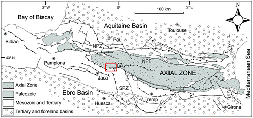
The Pyrenees extend for about 450 km from the Bay of Biscay to the Mediterranean Sea along the border between France and Spain (). They are a collisional mountain belt formed during Late Cretaceous to Miocene times due to the convergence between Iberian and European plates. From North to South one can distinguish: The Aquitaine foreland basin, overthrust by the North Pyrenean Zone, composed by intensely deformed Mesozoic and Cenozoic sediments with isolated exposures of Paleozoic basement and subcontinental mantle in the North Pyrenean Fault; the Axial Zone (AZ), made up of Paleozoic rocks overlain by some remnants of Mesozoic; the South Pyrenean Zone (SPZ) consists of Mesozoic and Cenozoic series southward translated and overthrust and the Ebro foreland basin.
Figure 1. General sketch of the Pyrenees showing the location of the study area (red rectangle). NPZ: North Pyrenean Zone, NPF: North Pyrenean Fault, SPZ: South Pyrenean Zone. Simplified from Teixell (Citation1996).
The mapped area covers the southern border of the Axial Zone, dominated by a structural southward vergence, and the Northern part of the SPZ. The SPZ is the Mesozoic and Cenozoic cover of regional thrust units, as the Gavarnie nappe, and is affected by a large southward translation (CitationChoukroune, 1992). Imbricated thrust systems define a typical thin-skinned style for the SPZ.
2. Lithology
2.1 Axial Zone
A metasedimentary sequence of Devonian to Permian age, intruded by the Cauterets-Panticosa batholith to the Northeast, crops out in the studied area of the Axial Zone. Devonian rocks crop out extensively over the study area; they are characterised by a high fossil conTJOM but in general without biostratigraphic utility. Because of this, currently many formations lack an accurate age. The Lower Devonian is composed of alternating grey limestones, slates and massive limestones with great lateral continuity (CitationMandilar and Pacino Formations, (Ríos et al., 1987; CitationValero, 1974), (A)) and a minimum thickness of 200 m (Rodríguez, Citation2011). They are overlain by Emsian to Eifelian slates that crop out in the central part of the map with at least 500 m thickness; they laterally vary to slates with sandstone intercalations ((B)) and very fosiliferous ferruginous limestones to the top ((C)). Slates are covered by massive reef limestones (Foratata Limestones, Eifelian-Givetian, 300–400 m thick, (CitationRíos et al., 1987)). Upper Devonian rocks crop out preferably in the Northeast of the study area and consist of 70 to 100 m of well-stratified grey limestones (Upper Givetian to Lower Frasnian) overlain by a 300-m thick Frasnian detrital series (Pic Lariste and Sia Series).
Figure 2. (A) General view above the Caldares river, NE Panticosa, showing an alternation of Devonian massive limestones and slates deformed by Variscan folds. The upper part of the mountain, the grasslands, corresponds to the outcrop of Emsian to Eifelian slates. Coordinates: 42° 42′ 44″N; 0° 16′ 29″O. (B) Detail of an outcrop of slates showing two cleavages and a sandstone intercalation at the top. (C) Aspect in the field of the ferruginous limestones above Emsian slates and (D) Carboniferous limestones in ‘griotte’ facies.
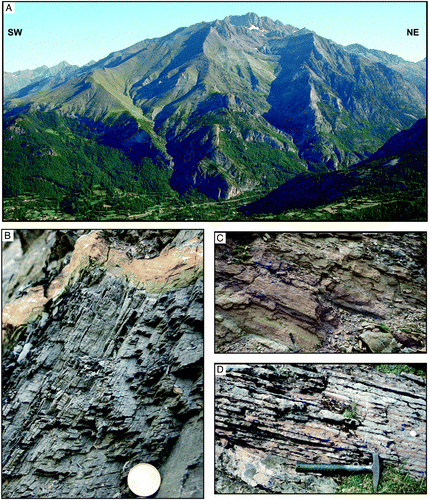
In the Northeast of the map, the Carboniferous is made up of 30-m thick Fammenian to Tournaisian carbonate rocks (undifferentiated in the map). In the rest of the area, Tournaisian to Namurian limestones, lidites, ‘griotte’ limestones ((C)), silex limestones, massive limestones and well-bedded black limestones to the top, with at least 200-m thick, crop out. They cover unconformably the Lower to Middle Devonian slates described earlier. Above them, slates and graywackes in the Culm Facies with plant fossils crop out ((A)); our data point to a minimum thickness of 500 m for these materials.
Figure 3. (A) Unconformable contact near Campo de Troya, Eastern border of the Anayet basin between red Permian rocks and Carboniferous in ‘Culm’ facies. The axial trace of F1 variscan folds is indicated in the ‘Culm’ facies and the alpine cleavage in Permian rocks. Coordinates: 42° 45′ 33″N; 0° 24′ 60″ O. (B) Contact between the Devonian slates of the Axial Zone and the Cretaceous series of the Sierras Interiores (SPZ). Coordinates: 42° 41′ 26″; N 0° 16′ 14″ O. Width: 100 m.
In the Northwestern area, in the so-called Anayet basin, Carboniferous and Devonian rocks are unconformably overlain by a detrital succession of Stephanian to Permian age ((A)). We have distinguished breccias, conglomerates, sandstones, slates and limestones, preferably in red colours and with a minimum thickness of 700 m. Interlayered with the Stephanian-Permian continental succession, basic to intermediate volcanic rocks related to volcanic episodes recognised all over the Pyrenees crop out (CitationBarnolas & Chiron, 1996).
2.2 The Cauterets-Panticosa batolith
In the Northeast of the study area, the Panticosa and the southern part of Western Cauterets plutons crop out. They belong to the Cauterets-Panticosa calc-alkaline and aluminous batholith, with an area greater than 250 km2. This batholith is actually one of the best known in the Pyrenees from the petrological and a structural perspective (CitationDebon, 1972; CitationGleizes et al., 1998; CitationMajesté-Menjoulás et al., 1999; CitationSantana, 2001, Citation2002). The intrusion age of the composite batholith is syn- to late-kinematic to the Variscan Orogeny, 266 ± 5 Ma (U-Pb SHRIMP; (CitationMajesté-Menjoulás et al., 1999)). They intrude in the Devonian series and generate a metamorphic aureole, mainly over calcareous rocks transformed to marbles with idocrase ± diopside ± epidote ± tremolite (CitationDebon, 1972), and near the intrusive contact with local flow of marbles that autointrude as the ‘Marmoleras de los Picos del Infierno’ (see map). Previous work (CitationDebon, 1972; CitationWensink, 1962) underestimated the width of the aureole, because only the first andalusite occurrence in metapelitic rocks was taken into account to cartography. Recently, the metamorphic aureole has been enlarged in more than 1.5 km (CitationRodríguez & Cuevas, 2009) from the first apparition of chloritoid (see map).
Acid and basic dykes related to this magmatism cut the host rocks and, even, the batholith.
2.3 South Pyrenean Zone
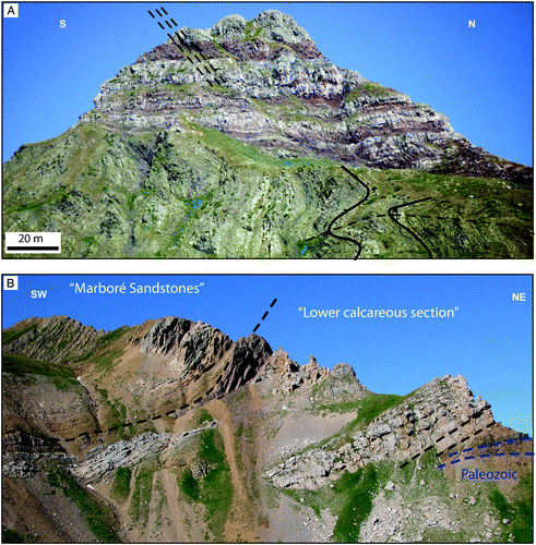
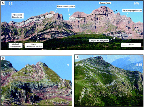
In the studied area there is a stratigraphic lacuna from Triassic to Lower Cretaceous (CitationJeurissen, 1962; CitationRíos et al., 1987). Thus, Upper Cretaceous to Paleocene rocks of the SPZ unconformably cover the rocks of the Axial Zone ((B)). These materials are concentrated in the southern part of the map constituting the Sierras Interiores, a WNW- trending range with high topography where we have distinguished three main lithological groups: Late Cenomanian to Early Campanian limestones with grey colour and massive aspect in landscape (Lower Calcareous section, 170 m); Campanian to Maastrichtian brown coloured sandstones (400–600 m, Marboré Sandstones); and Paleocene to Eocene light-coloured massive limestones (130–230 m, Paleocene limestones), that often constitute the highest areas of the Sierras Interiores due to their greater resistance to erosion.
On top of the sedimentary sequence of the Sierras Interiores, the Jaca Basin flysch succession of Cuisian to Lutetian age (CitationRíos et al., 1987) crops out unconformably. Previous work has described up to nine megabeds or megaturbidites intercalated in the turbidites of the Jaca Basin to the west of studied area (CitationLabaume et al., 1985). In the area surveyed we have observed that, from the Aragon valley to the East, those megabeds are progressively thinned and vanished (CitationRodríguez, 2011).
2.4 Quaternary deposits
Although representation of Quaternary deposits has been minimised on the map in order to emphasise the Variscan and Alpine structural features, they cover an extensive part of the area. We can distinguish: glacial deposits, alluvial deposits, alluvial fan deposits and landslide deposits amongst others, undifferentiated on the map.
3. Tectonic features
The Axial Zone is a south-vergent antiformal stack of variscan basement rocks generated during the Alpine Orogeny (CitationMuñoz, 1992; CitationRoure et al., 1989). In the central Pyrenees the main thrusts of Lakora-Cinq Monts, Gavarnie and Guarga are defined along different cross sections (CitationLabaume et al., 1985; CitationMillán Garrido et al., 2006; CitationTeixell, 1996).
In the South Pyrenean Zone Cretaceous to Cenozoic sedimentary rocks are deformed by a WNW-trending thrust-fold system in a piggy back sequence (CitationLabaume et al., 1985; CitationSeguret, 1972).
The Alpine Orogeny deformed the Paleozoic succession of the Axial Zone and the Upper Cretaceous to Paleogene rocks of the South Pyrenean Zone. In the SPZ a south directed complex thrust-fold system can be recognised. Two main thrust systems are distinguished in the Sierras Interiores (CitationRodríguez, 2011): the ‘Upper Thrust System’ and the ‘Deeper Thrust System’ ((A)). The ‘Upper Thrust System’ shows duplex and imbricate fan structures and deforms the Marboré Sandstones and the Paleocene limestones. The ‘Deeper Thrust System’ has a kilometric lateral continuity and duplicates the Lower Calcareous Section. The two thrust systems are eroded in their rear part, to the North of the Sierras Interiores.
Figure 4. (A) North face of the Western Sierras Interiores. The main sedimentary formations, the Upper Thrust System and the Lower Thrust System have been indicated. (B) Alpine asymmetric fold with axial planar cleavage deforming red Permian beds NE of Campo de Troya. Coordinates: 42° 46′ 43″N; 0° 24′ 53″O). (C) Variscan tight folds near the Pazino Peak. Coordinates: 42° 44′ 44″ N; 0° 21′ 11″O.
Asymmetric chevron folds deform the thrust systems in the SPZ and the Axial Zone ((B)); they show a wavelength of 800 m with fold axes oriented 10°/080°. Penetrative axial planar cleavage dips an average of 50° to the north and can be recognised throughout the study area. These folds and their related cleavage correspond to the F1/S1 structures in the SPZ and in the post-Stephanian rocks of the AZ, and to the F2/S2 structures in the pre-Stephanian rocks of the AZ ((A)).
In the Axial Zone large Variscan folds (F1) with axial planar cleavage (S1) deform pre-Stephanian rocks. Folds are West-vergent tight recumbent folds ((C)), with kilometric scale, that are oriented mainly N340°E in the present position. Nevertheless, there is variability in the Variscan fold and cleavage trending because they are refolded by the later alpine folds mentioned above. In fact, Ramsay type 2 fold interference patterns (CitationRamsay, 1967) of detailed complicated three-dimensional shape and kilometric scale can be observed in the study area (see map).
Finally, it should be emphasised that the AZ in this region exhibits a defomation previously attributed to the ‘Suprastructure’ (CitationCarreras & Capella, 1994). The ‘Suprastructure’ in the AZ of the Pyrenees is traditionally thought of as being characterised by upright folds and almost vertical cleavage. However, we identified that the geometry of the F1 folds in the pre-Stephanian rocks are recumbent kilometric folds with a little dipping of the associated cleavage.
Another interesting structure originated by the Alpine Orogeny between the Tena and Aragón valleys is the produced tectonic inversion of the Anayet basin (see the NW part of the map). The southern contact of the basin near the Aragón valley places Permian over Carboniferous rocks and has been recently interpreted as a synsedimentary normal fault reversed during the Alpine Orogeny (CitationRodríguez et al., 2012; CitationRodríguez-Méndez et al., In press).
Moreover, the ‘Upper thrust system’ defined here for the Sierras Interiores can be correlated with other structures identified in areas close to that mapped herein: to the West with the Larra thrust (CitationTeixell, 1992; CitationTeixell & García Sansegundo, 1995), and to the East with the Monte Perdido thrust (CitationParish, 1984; CitationSeguret, 1972). Nevertheless, although the ‘Deeper thrust system’ has a kilometric lateral continuity it had not been described in previous work.
4. Conclusions
Detailed field mapping between the Tena and Aragon valleys has allowed us to characterise two principal deformation phases in the border of the Axial Zone and the SPZ:
| • | A Variscan one, with kilometric tight recumbent folds and axial planar cleavage oriented mainly N340°E, that deform the Axial Zone rocks. | ||||
| • | An Alpine one with WNW trending structures: two south directed thrust systems deforming the South Pyrenean Zone and southward vergence chevron folds with axial planar cleavage. They deform the South Pyrenean Zone and the Axial Zone generating Ramsay type 2 interference fold patterns in the pre-Stephanian rocks. | ||||
Software
The geological map was drawn using Arcgis 9.3. The cross sections presented in the geological map and the photographs and figures cited in the text were drawn using Adobe Illustrator CS5.
Main Map: Geological Map of the Central Pyrenees between the Tena and Aragon Valleys (Huesca)
Download PDF (7.2 MB)Acknowledgements
We are grateful to Dr. García-Senz, Dr. Ábalos, Dr. Gill and an anonymous reviewer for their constructive reviews that helped us to improve the original manuscript. This work has been supported by grants [CGL2010-14869BTE and CGL2011-23755BTE] (MICINN, Spain) and [IT-364-10] (Basque Country, Spain).
References
- Barnolas, A., & Chiron, J. C. (1996). Synthèse Géologique et Géophysique des Pyrénées. Vol. 1: Introduction. Géophysique. Cycle Hercynien. Édition BRGM-ITGE.
- Carreras , J. and Capella , I. 1994 . Tectonic levels in the Paleozoic basement of the Pyrenees - A review and a new interpretation . Journal of Structural Geology , 16 : 1509 – 1524 . (doi:10.1016/0191-8141(94)90029-9)
- Choukroune , P. 1992 . Tectonic evolution of the Pyrenees . Annual Review of Earth and Planetary Sciences , 20 : 143 – 158 . (doi:10.1146/annurev.ea.20.050192.001043)
- Debon , F. 1972 . Notice explicative pour la carte géologique à 1/50000, Massifs granitiques de Cauterets et Panticosa (Pyrénées occidentales) , Orléans : BRGM, CNRS .
- Gleizes , G. , Leblanc , D. , Santana , V. , Olivier , P. and Bouchez , J. L. 1998 . Sigmoidal structures featuring dextral shear during emplacement of the Hercynian granite complex of Cauterets-Panticosa (Pyrenees) . Journal of Structural Geology , 20 : 1229 – 1245 . (doi:10.1016/S0191-8141(98)00060-1)
- Jeurissen , G. F.J. 1962 . Geology of the upper cretaceous part of the lower tertiary between the rio Aragon Subordan and the Rio Gallego (Spanish Pyrenees, Province of Huesca) . Geologica Ultraiectina , 10 : 1 – 71 .
- Labaume , P. , Séguret , M. and Seyve , C. 1985 . Evolution of a turbiditic foreland basin and analogy with an accretionary prism: Example of the eocene south-pyrenean basin . Tectonics , 4 : 661 – 685 . (doi:10.1029/TC004i007p00661)
- Majesté-Menjoulás , C. , Debon , F. and Barrère , P. 1999 . Notice explicative, Carte géol. France (1/50 000), feuille Gavarnie (1082) , 158 Orléans : BRGM . Carte géologique par C. Majesté-Menjoulás, F. Debon
- Millán Garrido , H. , Oliva-Urcia , B. and Pocoví , A. 2006 . La transversal de Gavarnie-Guara. Estructura y edad de los mantos de Gavarnie, Guara-Gèdre y Guarga (Pirineo centro-occidental) . Geogaceta , 40 : 35 – 38 .
- Muñoz , J. A. 1992 . “ Evolution of a continental collision belt - ECORS-Pyrenees crustal balanced cross-section ” . In Thrust tectonics , Edited by: McClay , K. R. 235 – 246 . London : Chapman & Hall .
- Parish , M. 1984 . A structural interpretation of a section of the Gavarnie nappe and its implications for Pyrenean geology . Journal of Structural Geology , 6 : 247 – 255 . (doi:10.1016/0191-8141(84)90049-X)
- Ramsay , J. G. 1967 . Folding and fracturing of rocks , 560 New York : McGraw-Hill .
- Ríos , J. M. , Galera , J. M. , Barettino , D. and Lanaja , J. M. 1987 . Hoja 145 (Sallent) del Mapa Geológico de España a escala 1:50.000 y Memoria geológica , Madrid : I.G.M.E .
- Rodríguez, L. (2011). Análisis de la estructura varisca y alpina en la transversal Sallent-Biescas (Pirineos centrales, Huesca). Ph. D. Thesis, Universidad del País Vasco UPV/EHU, 186 p. Published by Laboratorio Xeolóxico de Laxe, Serie Nova Terra no 41 (2012).
- Rodríguez , L. and Cuevas , J. 2009 . Presencia de cloritoide en la aureola térmica de los plutones de Cauterets occidental-Panticosa (Zona Axial del Pirineo, Huesca) . Geogaceta , 47 : 133 – 136 .
- Rodríguez , L. , Cuevas , J. and Tubía , J. M. 2012 . Estructura de inversión tectónica positiva en la cuenca de Anayet (Pirineos centrales, Huesca) . Geotemas , 13 04_162 O 1-4
- Rodríguez-Méndez , L. , Cuevas , J. , Tubía , J. M. , Esteban , J. J. , Sergeev , S. and Larionov , A. “ Age of the magmatism related to the inverted Stephanian-Permian basin of the Sallent area (Pyrenees) ” . In Deformation structures and processes within the continental crust , 394 London : The Geological Society, special publications . In press
- Roure , F. , Choukroune , P. , Berastegui , X. , Muñoz , J. A. , Villien , A. , Matheron , P. , Bareyt , M. , Séguret , M. , Camara , P. and Deramond , J. 1989 . Ecors deep seismic data and balanced cross-sections - Geometric constraints on the evolution of the pyrenees . Tectonics , 8 : 41 – 50 . (doi:10.1029/TC008i001p00041)
- Santana, V. (2001). El Plutón de Panticosa (Huesca, Pirineos): Estructura y modelo de emplazamiento a partir del análisis de la anisotropía de la susceptibilidad magnética, Ph.D. Thesis. Universidad del País Vasco UPV/EHU, p. 146.
- Santana , V. 2002 . El plutón de Panticosa (Pirineos occidentales, Huesca): Fábrica magnética y modelo de emplazamiento . Rev. Soc. Geol. España , 15 : 175 – 191 .
- Séguret, M. (1972). Étude tectonique des nappes et séries décollées de la partie centrale du versant sud des Pyrénées. Caractère synsédimentaire, rôle de la compression et de la gravité, Publications USTELA. Série Géologie Structurale no 2. Montpellier, p. 155.
- Teixell, A. (1992). Estructura alpina en la transversal de la terminación occidental de la Zona Axial pirenaica, Ph.D. Thesis. Universidad de Barcelona, p. 252.
- Teixell , A. 1996 . The Anso transect of the southern Pyrenees: Basement and cover thrust geometries . Journal of the Geological Society , 153 : 301 – 310 . (doi:10.1144/gsjgs.153.2.0301)
- Teixell , A. and García Sansegundo , J. 1995 . Estructura del sector central de la Cuenca de Jaca (Pirineos meridionales) . Rev. Soc. Geol. España , 8 : 215 – 228 .
- Valero, J. (1974). Géologie structurale du Paleozoique de la région de Panticosa Province de Huesca (Spagne). Thèse 3ème Cycle. Université de Bordeaux, p. 78.
- Wensink , H. 1962 . Paleozoic of the upper Gállego and Ara valleys, Huesca province, Spanish Pyrenees . Estudios Geológicos , XVIII : 1 – 74 .