Abstract
A 1:28,000 scale geomorphological map of the central sector of the Matese Mountains (Southern Italy) is presented in this paper. Geomorphological investigation by means of remote sensing, cartographic analysis and field surveys allowed the identification of the main geomorphic processes and to map the related landforms which are both of monogenetic and polygenetic origin. Most of them are erosional landforms generated by the action of periglacial, glacial and karst processes which often occur under the control of the geological structure. Glacial relics and polygenetic landforms of glaciokarst and fluviokarst origin provide good evidence of the strong influence of variable climatic conditions on landform genesis during the Quaternary. They also highlight the influence of extensive tectonics during the Quaternary which caused progressive uplift, fragmentation and disarticulation of the developing mountainous landscape and its consequent polycyclic evolution. The map illustrates the geomorphologic peculiarities of the Mediterranean mountain landscape that typically characterizes the Apennine chain, and contributes to the understanding of its tectonic evolution and the influence of climate and climatic changes on landscape evolution. It further provides a basic map for land planning policy including the exploitation of the geological heritage and the development of sustainable mountain tourism and geo-tourism.
1. Introduction
The present morphological setting of the Apennine chain, formed by the Southern and the Northern Apennine arcs (), is the result of long-term evolution under the control of Pliocene-Pleistocene tectonics that caused its progressive uplift and consequent dissection. The inner sector of the Southern Apennine is a large carbonate mountain chain with major peaks reaching ∼2000 m whose northernmost portion includes the Matese Mountains ().
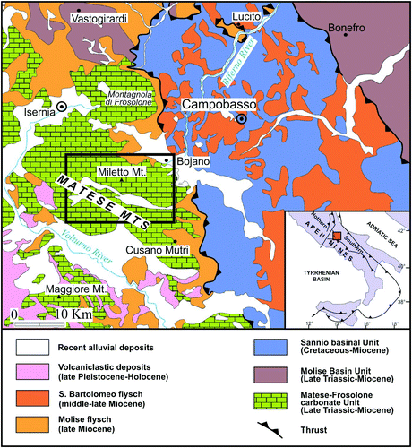
Figure 1. Geological sketch map of the north-eastern portion of the Southern Apennines with the location of the study area (modified after Vezzani et al., 2004).
Previous studies on the Matese Mts. mainly deal with its geological and structural evolution and its hydro-geological aspects (see especially CitationCalabrò, Corrado, Di Bucci, Robustini, & Tornagli, 2003; CitationCarannante et al., 2009; CitationPetrella & Celico, 2009; CitationPappone, Aucelli, Cesarano, Putignano, & Ruberti, 2013 and references herein), whereas morphological aspects, apart from several studies focused on glacial and karst features (CitationGiraudi, 1999; CitationPalmentola & Acquafredda, 1983; CitationRusso, Del Prete, Giulivo, & Santo, 2005 and references herein; CitationAmato, Aucelli, Brancaccio, Cesarano, & Rosskopf, 2010b) are currently poorly investigated.
The geomorphological map we have produced illustrates its central sector, covering ∼170 km2. This sector represents an excellent example of the Mediterranean mountain landscape that typically characterizes the Apennine chain. These areas are important in order to understand the long-term evolution of the Apennines as they are rich in landforms that highlight the influence of Quaternary tectonic phases and variable climatic conditions on landscape evolution. The significance of the map therefore mainly consists in its contribution to understanding the evolution of Mediterranean mountain environments under the control of tectonics and climate and the related genesis of climate relics and polygenetic landforms. Furthermore the information it provides on the distribution and characteristics of the mapped landforms can be useful in the assessment of geologic heritage (still in progress, CitationFilocamo et al., 2011) and the related natural resources, and in the development of sustainable tourism and geo-tourism within the Matese Mts.
2. Physiographic and geologic setting of the study area
The study area coincides with the central sector of the Matese Mts., an ∼1000 km2 wide, NW-SE elongated carbonate massif ().
The Matese Massif is made of predominantly carbonate rocks derived from a Meso-Cenozoic carbonate platform domain (Apennine Carbonate Platform according to CitationMostardini & Merlini, 1986) and is part of the Matese-Frosolone Unit (CitationPappone et al., 2013). Miocene siliciclastic deposits crop out along the edges of the Massif and are locally preserved within the tectonic depressions.
From a structural perspective, the Matese Massif appears as a single NE-verging thrust sheet generated during the Late Miocene-Pliocene compressive tectonic regime (CitationCesarano et al., 2011; CitationDi Bucci, Corrado, Naso, Parotto, & Praturlon, 1999; CitationPappone et al., 2013). From the Late Pliocene to Early Pleistocene it was affected by intense fragmentation due to strike-slip and normal faults mainly aligned in the NW-SE and NE-SW directions. Since the Middle Pleistocene, a NE-SW oriented extensional tectonic regime became dominant (CitationAmato et al., 2011; CitationCorrado, Di Bucci, Naso, & Butler, 1997; CitationFerranti, 1997; CitationPatacca, Scandone, Bellatalla, Perilli, & Santini, 1992): it caused intense block-faulting. Blocks were displaced at various elevations, Graben and Horst structures were formed at various scale, and this led to the modern structural setting of the Matese Massif – a horst laterally bounded by large tectonic depressions, such as the Boiano basin and the Volturno valley, filled with continental deposits (CitationAmato et al., 2010a, Citation2012; CitationAucelli et al., 2011a; CitationDi Bucci et al., 1999).
The Molise Apennines and with it the Matese Massif, feature numerous relicts of paleosurfaces, mostly of erosional origin, which represent the remnants of gently rolling ancient landscapes (CitationAucelli et al., 2010) that generated during phases of substantial tectonic stability interrupted by various phases of uplift, and are now hanging at different altitudes above the local base-levels of erosion. Four orders of paleosurfaces are recognized (CitationAucelli et al., 2011b) with the most ancient (I order paleosurface) being located at elevations between 1100 and 2000 m a.s.l.
Due to its structural setting and the widespread presence of paleosurfaces, the central sector of the Matese Massif is dominated by a low-relief plateau-like morphology. Its highest peaks are Mount Miletto (2050 m), La Gallinola (1923 m) and Mount Mutria (1823 m). Its surface drainage network, though relatively poor due to prevailing subterranean karst drainage (see later), allows the subdivision it in two sectors which are characterized by surface drainage systems directed south-westwards to the Tyrrhenian side and north-eastwards to the Adriatic side, respectively. The latter, in particular, feeds one of the major water courses of the Molise region, the Biferno River (). This river is characterized by a unique headwater zone whose centre is the Boiano basin, generated by extensional tectonics during the Quaternary (CitationAmato et al., 2012; CitationRosskopf & Scorpio, 2013), and receives consisTJOM water supplies from the karst springs at the base of the Matese slope at ∼500 m a.s.l.
From a climatic perspective, the inner mountain sector of the Matese Mts. is characterized by a Mediterranean, warm-temperate humid climate (climate class Cfb according to the classification of Köppen, CitationAucelli, Izzo, Mazzarella, & Rosskopf, 2007). The weather station of Campitello Matese, located at ∼1400 m a.s.l. within the central-northern sector of the study area, registers mean annual temperatures and precipitations of 7.2°C and 1847 mm, respectively (CitationAmato et al., 2010b).
3. Methods
The geomorphological map is the result of a detailed cartographic analysis of 1:5000 scale topographic sheets of the Carta Tecnica Regionale (CTR) and the Carta Tecnica Numerica Regionale maps, edited by the Molise Region and the Campania Region in 1992 and 2004, respectively, coupled with the interpretation of large scale aerial photos and field surveys carried out in 2010 and 2011.
The legend focuses on the genesis of morphological features and uses coloured symbols and surfaces to represent various form groups (glacial, karst, etc.), largely following the mapping systems proposed by CitationBrancaccio et al. (1994) and CitationCastiglioni et al. (1999). The mapped polygenetic landforms are represented by symbols and surfaces using hatchings of different colour chosen to highlight them as best as possible.
The geomorphologic features were first mapped by hand on the 1:5000 scale topographic sheets and then digitized on 1:25,000 scale sheets of the Carta Topografica d'Italia map, edited by the Italian Military Geographic Institute.
In order to improve map interpretation, basic information on outcropping lithologies was added. This information was primarily extracted from the new geological map of Italy at scale 1:50,000 (sheet 405 Campobasso, CARG Project, CitationPappone et al., 2013) and integrated and validated during field surveys.
For the final layout, the map was reduced to a scale of 1:28,000 and printed on a topographic map base with 50 m spaced contour lines and 25-m spaced auxiliary lines, derived from the 25-m resolution digital elevation model (DEM) edited by the Italian Military Geographic Institute and integrated with selected elevation points, especially to indicate major peaks.
Besides the 1:28,000 scale geomorphological map, the final cartographic product includes a geological sketch map of the study area, a geological cross section and two 3D scenes, showing the Matese Lake area and the Campitello area, respectively.
To obtain the geological sketch map, the layer containing geological information was overlain on a hillshade model derived from the 25-m resolution DEM. The 3D scenes were obtained by overlaying orthophotos of 2007 and geomorphological data on the 25-m resolution DEM.
4. The geomorphological map
Lithological information included in the map refers mainly to the pre-Quaternary bedrock. The following two units were distinguished: the Molise Flysch Unit (CitationPappone et al., 2013) made up of marls, clays and sandstones of turbidite basin environment (Middle Tortonian-Messianian) and the Matese Carbonate Unit (Late Triassic-Late Cretaceous), from bottom to the top made up of: (1) dolomites and calcareous dolomites of inner shelf environment, (2) limestones of inner shelf environment, rich in molluscs and corals and (3) bioclastic limestones of shelf margin-upper slope environment, rich in rudist fragments.
The legend also includes information on the main springs and streams, the perimeter of the Matese Lake (extracted from aerial photos of 1998) and the artificial levees located around it. The latter, constructed in the 1920s, ensure the persistence of the lake, as they buffer the two major ponors that formerly provided for the drainage of the polje.
The identified landforms and deposits are grouped and described as follows: (i) Glacial landforms and deposits; (ii) Karst landforms; (iii) Fluvial landforms; (iv) Slope landforms; (v) Tectonic and structurally controlled landforms; and (vi) Polygenetic landforms.
4.1 Glacial landforms and deposits
The glacial processes which affected the Matese Mts. during the Quaternary have left evidence in the northern sector of the study area. The best-preserved glacial landforms are represented by the glacial cirques, with the largest one, the so-called Circo Maggiore, being located between 2000 and 1775 m a.s.l. on the north-eastern slope of Mt. Miletto ((A); 3D scene of Campitello area). Smaller cirques are visible at lower altitudes along the north-eastern slope of Mt. Miletto and the northern slope of Colle Tamburo. Along the latter, arêtes and glacial troughs ((B)) testify to the descent of valley glaciers at least to 1200 m a.s.l. Other glacial forms are represented by several cirque-like hollows located on the slopes of Mt. Miletto, between approximately 2000 and 1600 m a.s.l.
Figure 2. Panoramic views of the major cirque of Mt. Miletto, named Circo Maggiore, (A) and of the arête that separates the two glacial troughs departing from the eastern cirques of Colle Tamburo (B); the moraine deposits outcropping immediately north to the Campitello Plain (C) and near the Stazione Teleferica (D) at ∼1400 and 800 m a.s.l., respectively, made of prevailing sub-angular, centimetric to metric calcareous clasts in abundant sandy-silty matrix.
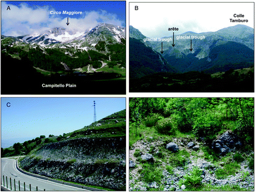
Moraine deposits, Last Glacial Maximum in age, are widespread within and immediately north of the Campitello Plain at above 1400 m a.s.l. They consist of mainly sub-angular, strongly heterometric, calcareous clasts with sandy-silty matrix ((C)). Older moraines (Middle Pleistocene in age, CitationAmato et al., 2010b; CitationPappone et al., 2013) outcrop along the northern piedmont area of the Matese Massif close to the Stazione Teleferica ((D)) and at Colle delle Castagne between 800 and 700 m a.s.l.
4.2 Karst landforms
Karst landforms are widespread. The most common exokarst features are represented by dolines, closed and open karst depressions of various sizes and forms, frequently more or less elongated, and poljes. Dolines are mostly generated by dissolution and are often located on gently sloping surfaces (particularly on erosion surfaces of fluviokarst origin, see below); they are sometimes inactive due to tectonics or being captured by gullies ((A)). The closed and open karst depressions are characterized by endorheic and exorheic drainage, respectively, and often host two or more dolines, too small to be represented on the map.
Figure 3. View of the open karst depression located west to the Campo Puzzo polje (the dashed black arrows indicate the direction of surface drainage); in the background, the dolines present on the surfaces of fluviokarst origin of Serra le Tre Finestre (A); panoramic view of the Matese Lake polje (B) and of the Campitello Plain polje in June 2012 (C) and May 2009 (D).
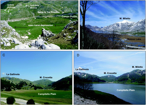
Most of the poljes are of tectonic origin, generated due to extensional tectonics and block-faulting. The major structurally controlled polje is that of Matese Lake ((B) and 3D scene of Matese Lake area), which is aligned to the north-west with the Campo delle Secine polje and controlled by WNW-ESE normal faults. Other examples are represented by the W-E aligned depressions of Campo Rotondo, Mass. Vallecupa and Campo Braca, located in the SW sector of the study area, and by the Campitello ((C) and 3(D)) and Campo Puzzo depressions, located in its NE sector. Polje and karst depression floors are generally covered with lacustrine and palustrine deposits, alternating with in situ and reworked volcaniclastic sediments, terra rossa and paleosoils. The widespread presence of volcaniclastic deposits both on morphologically mature surfaces and within depressions plays an important role in the development of karst: their minerals contribute to increase the acidity of water and, therefore, confer more intensity and effectiveness in depth to dissolution processes (CitationCelico et al., 2010). The Matese Massif is also rich in endokarst features which are represented mainly by extensive caves systems characterized by a predominantly horizontal development and related to ancient groundwater levels (CitationSantangelo & Santo, 1991). Examples are the Campo Braca system located in the SW sector of the study area and the famous Pozzo della Neve and Cul di Bove systems (CitationFilocamo et al., 2011; CitationRusso et al., 2005), located immediately eastward of the study area.
In the study area various caves, which are located on the map on the basis of the Catasto delle Grotte della Campania (CitationFederazione Speleologica Campana, 2005) and the Carta escursionistica dei sentieri del Matese (CitationCAI, 2008), are present.
Most of the mapped ponors are located along polje edges, i.e. along the tectonic lineaments that created them, as in the case of the two ponors of Matese Lake polje, which are found along its southern edge. The active endokarst system of the study area frequently intercepts the topographic surface as highlighted by various karst springs such as the Capo Lete spring from which the Lete River originates.
4.3 Fluvial landforms
Depositional fluvial landforms are represented by alluvial fans ((A)) present within the main tectono-karstic depressions at the mouth of major tributaries. Within the Matese Lake polje, at least two generations of alluvial fans are identified, the older one being cut by the present-day streams. They are mainly made of rounded carbonate gravels, blocks and sands with sandy-silty matrix, and are dated to the Late Pleistocene-Holocene (CitationPappone et al., 2013).
Figure 4. The major alluvial fan present within the Matese Lake polje (A); the southern slope of Serra delle Vallocchie Scure, intensively dissected by gullies (B).
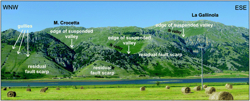
Erosional fluvial landforms are represented mainly by gullies, gorges, valley steps and edges of suspended valleys. Locally, gully incisions intensely dissect the slopes as in the case of the Serra delle Vallocchie Scure ((B)) and La Gallinola northern slopes.
The valley steps and the edges of suspended valleys recognized in the study area are often related to relics of ancient paleo-landscapes (i.e. the erosion surfaces of fluviokarst origin), nowadays truncated and suspended over the local current base-level by Middle Pleistocene tectonic extension ().
Figure 5. View of the residual fault scarps of Mt. Crocetta and La Gallinola, bordering the Matese Lake polje to the north. This is shown by the edges of some of the suspended valleys of fluviokarst orgin (fk valley) and some gully incisions.
4.4 Slope landforms
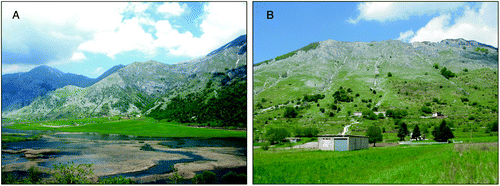
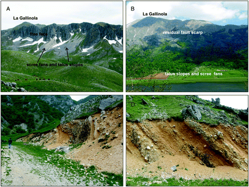
Slope landforms are represented essentially by talus slopes and scree fans located mostly at the base of the residual fault scarps bordering the major karst depressions, as at the northern and southern slopes of La Gallinola ((A) and 6(B)), Mt. Crocetta and Mt. Miletto. Often polycyclic and Late Pleistocene to Holocene in age, they are made of angular/subangular heterometric carbonate clasts, often with sandy-silty volcaniclastic matrix, are locally stratified and characterized by a variable degree of cementation. The carbonate clasts mainly derive from cryoclastic processes that largely affect the high mountain slopes of the Matese Massif, often aided by karst dissolution.
Figure 6. The northern slope of La Gallinola with its free face and active talus slopes and scree fans (A); the southern slope of La Gallinola with largely vegetated and stabilized talus slopes and scree fans (B); the lithified talus slope outcropping at Serra delle Macchietelle, characterized by steeply inclined strata, clearly discontinuous to the actual slope (C), made of alternating layers of sands and carbonate clasts in sandy-silty matrix (D).
At the base of the southern slopes of Serra delle Macchietelle and Mt. Miletto, lithified talus slopes ((C)), TJOMatively interpreted as Middle Pleistocene in age (CitationPappone et al., 2013) are present. They consist of stratified cemented carbonate breccias with sandy-silty matrix whose high-angle strata ((D)) evidence that they have been tilted by faults. Locally, their top is cut by erosion surfaces of fluviokarst origin (see below), confirming their ancient origin.
4.5 Tectonic and structurally controlled landforms
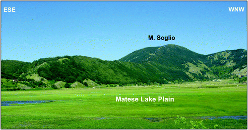
The high mountain landscape of the Matese Massif is dominated by tectonic and structurally controlled landforms. They mainly consist of residual fault scarps and of subsequent streams and fault-controlled gorges, which evidence and follow major tectonic lineaments, respectively (see also the geological sketch map). Residual fault scarps often border tectono-karstic depressions ( and ) and are responsible for the suspension of the erosion surfaces of fluviokarst origin and, most likely in some cases, for their tectonic duplication.
Figure 7. Panoramic view of the residual fault scarp of Mt. Soglio bordering southwards the Matese Lake polje.
4.6 Polygenetic landforms
The landforms included in this category are the result of the interaction of different genetic processes that have affected the study area over time.
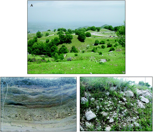
The most widespread forms are the erosion surfaces of fluviokarst origin, remnants of ancient hanging gentle and low relief erosional landscapes whose genesis can be related mainly to fluvial and karst processes. They are of various exTJOM and located between 1700 and 800 m a.s.l., but difficult to group into distinct orders. Cut into the carbonate bedrock, these surfaces sometimes exhibit a hummocky morphology ((A)), and often are characterized, in addition to dolines and karst depressions, by fluviokarst valleys. The latter are low-gradient valleys, normally dry and often truncated (), and displaced by tectonics. In the Matese Lake area, small remnants of fluviokarst surfaces also cut the Middle Pleistocene lithified talus slope described earlier. Erosion surfaces clearly dipping towards more or less deeply incised streams and gorges are interpreted as glacis of fluviokarst origin, and are marking phases of substantial tectonic stability followed by phases of valley downcutting.
Figure 8. View of the hummocky-like surface of fluviokarst origin of Pianelle, located north to Serra le Tre Finestre (A); detailed views of the laminated fluvio-lacustrine deposits of Serra San Giorgio, made of silts and clays with interbedded reworked volcaniclastic material and rounded pebbles (B) and of the glacial deposits above (C), made of angular and subangular heterometric, calcareous clasts with sandy-silty matrix.
At altitudes above 1700 m a.s.l., between Colle Tamburo and Mt. Miletto, some remnants of erosion surfaces of glaciokarst origin can be observed. Their genesis is due to the interplay between dissolution processes and ice action during the Pleistocene glacial periods. These surfaces are characterized by the presence of grooves and ridges and probably hosted glaciers that fed the underlying glacial cirques. Other glaciokarst features are represented by the small glaciokarst depressions that characterize the summit of La Gallinola.
Erosional and depositional fluvio-lacustrine terraces are present at ∼800 m a.s.l. in the northern sector of the study area, near Colle delle Castagne and Serra San Giorgio. They include the well-known depositional terrace of Serra San Giorgio whose deposits ((B)), hanging about 300 m above the Bojano plain, infer an ancient lake basin which has been dated to the Lower Pleistocene (CitationBrancaccio et al., 1979) and recently re-dated to the Middle Pleistocene (CitationDi Bucci et al., 2005). On top of the lacustrine succession, moraine deposits, pre-Last Glacial in age ((C)), crop out, too small to be mapped at scale.
5. Conclusions
The 1:28,000 scale geomorphological map of the central sector of Matese Mts. (Southern Italy) has been illustrated. It highlights the main geomorphic processes and related landforms that typically characterize the Mediterranean mountain landscape of the Apennine chain.
In addition to monogenetic landforms, polygenetic landforms, generated by the interaction of different genetic processes that have affected the study area over time, are widespread.
Climate relics, such as the glacial landforms and the polygenetic erosional landforms of glaciokarst and fluviokarst origin, highlight the influence of variable Quaternary climatic conditions on landscape evolution. These landforms, together with tectonic forms, also give clear evidence of the extensive tectonism that has affected the Matese Massif during the Pleistocene, causing its progressive uplift, fragmentation and disarticulation and, therefore, are important in deciphering its geological evolution. The map can be also a useful tool in assessing the geologic heritage of the Matese Mts. and provides a contribution toward the development of sustainable tourism and, especially, geo-tourism.
Software
The topographic map base and the hillshade model of the Matese Massif were constructed using ESRI ArcGIS 10; the 3D scenes were created using ArcScene. The final map design, the geological section and the geological sketch map, including the symbols shown in the legend, were produced using Corel Draw software.
Main Map: Geomorphological Map of the Matese Mountains (Southern Italy): An Example of Complex Landscape Evolution in a Mediterranean Mountain Environment
Download PDF (12.4 MB)Acknowledgements
The authors wish to thank Dr. R. Pellitero and two anonymous reviewers for the useful suggestions to improve both manuscript and map. The authors are also grateful to Prof. L. Brancaccio for a critical review of the manuscript.
Related Research Data
References
- Amato , V. , Aucelli , P. , Brancaccio , L. , Cesarano , M. and Rosskopf , C. 2010b . “ Inquadramento geologico-ambientale e geomorfologico ” . In Guida pedologica ai suoli forestali del Matese molisano , Edited by: Colombo , C. 62 – 97 . Itinerari pedologici italiani/1, Aracne editrice .
- Amato , V. , Aucelli , P. P.C. , Cesarano , M. , Pappone , G. , Petrosino , P. , Rosskopf , C. and Russo Ermolli , E. 2010a . New chrono-stratigraphic data on the Boiano basin infilling (Molise, Italy) . Rendiconti Online Della Società Geologica Italiana , 11 : 614 – 615 .
- Amato , V. , Aucelli , P. P.C. , Cesarano , M. , Pappone , G. , Rosskopf , C. M. and Russo Ermolli , E. 2011 . The Sessano intra-montane basin: New multi-proxy data for the Quaternary evolution of the Molise sector of the Central-Southern Apennines (Italy) . Geomorphology , 128 : 15 – 31 . (doi:10.1016/j.geomorph.2010.12.019)
- Amato , V. , Aucelli , P. P.C. , Russo Ermolli , E. , Rosskopf , C. M. , Cesarano , M. and Pappone , G. 2012 . Quaternary morpho-evolution, tectonic and environmental changes in the Boiano intermontane basin (central-southern Italy) . Rendiconti Online Società Geologica Italiana , 21 : 1225 – 1227 .
- Aucelli , P. P.C. , Amato , V. , Baranello , S. , Cesarano , M. , Mastronardi , R. , Monaco , R. and Rosskopf , C. 2011a . Nuovi dati sull'evoluzione pleistocenica dei bacini intramontani di Boiano e di Sessano (Molise, Italia meridionale) . Rendiconti Online Della Società Geologica Italiana , 12 : 3 – 7 .
- Aucelli , P. P.C. , Amato , V. , Cesarano , M. , Pappone , G. , Rosskopf , C. , Russo Ermolli , E. and Scarciglia , F. 2011b . New morphostratigraphic and chronological constraints for the Quaternary palaeosurfaces of the Molise Apennines (southern Italy) . Geologica Carpathica , 62 ( 1 ) : 17 – 26 . (doi:10.2478/v10096-011-0002-2)
- Aucelli , P. P.C. , Izzo , M. , Mazzarella , A. and Rosskopf , C. 2007 . La classificazione climatica della regione Molise . Bollettino Della Società Geografica Italiana , 12 : 615 – 638 .
- Aucelli , P. P.C. , Robustelli , G. , Rosskopf , C. M. , Scarciglia , F. , Di Paola , G. and Lucà , F. 2010 . Geomorphologic map of the area between Frosolone and Trivento (Molise, Italy) . Journal of Maps , 6 ( 1 ) : 423 – 434 . (doi:10.4113/jom.2010.1039)
- Brancaccio , L. , Castiglioni , G. B. , Chiarnini , E. , Cortemiglia , G. , D'Orefice , M. , Dramis , F. and Pellegrini , G. B. 1994 . Carta geomorfologica d'Italia – 1:50.000 . Guida al Rilevamento, Quaderni del Servizio Geologico Nazionale, serie III , 4 : 1 – 42 . …
- Brancaccio , L. , Cinque , A. , Orsi , G. , Pece , R. , Rolandi , G. and Sgrosso , I. 1979 . Lembi residui di sedimenti lacustri pleistocenici sospesi sul versante setTJOMrionale del Matese, presso S. Massimo . Bollettino della Socìietà dei Naturalisti in Napoli , 88 : 275 – 286 .
- CAI. (2008). Carta escursionistica dei sentieri del Matese 1:25.000 – Versante setTJOMrionale/Settore orientale. CAI Molise, CM Boiano, Reg. Molise, Isernia 2008.
- Calabrò , R. A. , Corrado , S. , Di Bucci , D. , Robustini , P. and Tornagli , M. 2003 . Thin-skinned vs. thick-skinned tectonics in the Matese Massif, central-Southern Apennines (Italy) . Tectonophysics , 377 : 269 – 297 . (doi:10.1016/j.tecto.2003.09.010)
- Carannante , G. , Pugliese , A. , Ruberti , D. , Simone , L. , Vigliotti , M. and Vigorito , M. 2009 . Evoluzione cretacica di un settore della piattaforma apula da dati di sottosuolo e di affioramento (Appennino campano-molisano) . Bollettino della Società Geologica Italiana , 128 ( 1 ) : 3 – 31 .
- Castiglioni , G. B. , Biancotti , A. , Bondesan , M. , Cortemiglia , G. , Elmi , C. , Favero , V. and … Tellini , C. 1999 . Geomorphological map of the Po Plain, Italy, at a scale of 1:250000 . Earth Surface Processes and Landforms , 24 : 1115 – 1120 . (doi:10.1002/(SICI)1096-9837(199911)24:12<1115::AID-ESP38>3.0.CO;2-Z)
- Celico , F. , Naclerio , G. , Bucci , A. , Nerone , V. , Capuano , P. , Carcione , M. and Celico , P. 2010 . Influence of pyroclastic soil on epikarst formation: A test study in southern Italy . Terra Nova , 22 : 110 – 115 . … (doi:10.1111/j.1365-3121.2009.00923.x)
- Cesarano , M. , Pappone , G. , Amato , V. , Aucelli , P. , Baranello , S. , Cascella , A. and Rosskopf , C. 2011 . Stratigrafia ed assetto geometrico dell'Unità del Sannio nel settore setTJOMrionale dei monti del Matese . Rendiconti Online della Società Geologica Italiana , 12 : 35 – 38 . …
- Corrado , S. , Di Bucci , D. , Naso , G. and Butler , H. W.R. 1997 . Thrusting and strike-slip tectonics in the Alto Molise region (Italy): Implications to the Neogene-Quaternary Evolution of the Central Apennines Orogenic System . Journal of Geological Society of. London , 154 : 679 – 688 . (doi:10.1144/gsjgs.154.4.0679)
- Di Bucci , D. , Corrado , S. , Naso , G. , Parotto , M. and Praturlon , A. 1999 . Evoluzione tettonica neogenico-quaternaria dell'area molisana . Bollettino della Società Geologica Italiana , 118 : 13 – 30 .
- Di Bucci , D. , Naso , G. , Corrado , S. and Villa , I. 2005 . Growth, interaction and sismogenic poTJOMial of coupled active normal faults (Isernia Basin, Central-Southern Italy) . Terra Nova , 17 : 44 – 55 . (doi:10.1111/j.1365-3121.2004.00582.x)
- Federazione Speleologica Campana. (2005). Catasto delle grotte della Campania.
- Ferranti , L. 1997 . Tettonica tardo pliocenica-quaternaria dei Monti del Matese (Appennino meridionale): Raccorciamenti tardivi e distensione «neotettonica» . Il Quaternario , 10 ( 2 ) : 503 – 506 .
- Filocamo, F., Maglieri, C., Rosskopf, C. M., Baranello, S., Giannantonio, O., Monaco, R., … Iarossi, M. (2011). Il censimento e la valorizzazione dei geositi: l'esperienza molisana. Geologia dell'Ambiente, supplemento al n.2/2011, Atti del Convegno Nazionale ‘Il Patrimonio Geologico: Una risorsa da proteggere e valorizzare’, 29 e 30 aprile 2010, Sasso di Castalda – Potenza, 135–143.
- Giraudi , C. 1999 . Datazione diretta e correlazione di depositi glaciali con l'uso di tephra e loess: il caso del Matese (Campania-Molise) . Il Quaternario , 12 ( 1 ) : 11 – 16 .
- Mostardini , E. and Merlini , S. 1986 . Appennino centro meridionale. Sezioni geologiche e proposta di modello strutturale . Memorie della Società Geologica Italiana , 35 : 177 – 202 .
- Palmentola , G. and Acquafredda , P. 1983 . Gli effetti dei ghiacciai quaternari sulla montagna del Matese, al confine molisano-campano . Geografia Fisica e Dinamica Quaternaria , 6 : 117 – 130 .
- Pappone , G. , Aucelli , P. P.C. , Cesarano , M. , Putignano , M. L. and Ruberti , D. 2013 . Note Illustrative del Foglio 405 ‘Campobasso’ della Carta Geologica d'Italia alla scala 1: 50.000 , Roma : ISPRA .
- Patacca , E. , Scandone , P. , Bellatalla , M. , Perilli , N. and Santini , U. 1992 . La zona di giunzione tra l'arco appenninico setTJOMrionale e l'arco appenninico meridionale nell'Abruzzo e nel Molise . Studi Geologici Camerti , 11 : 417 – 441 . Vol. Spec. (1991/2), CROP
- Petrella , E. and Celico , F. 2009 . Heterogeneous aquitard properties in sedimentary successions in the Apennine chain: Case studies in southern Italy . Hydrological Processes , 23 : 3365 – 3371 . (doi:10.1002/hyp.7441)
- Rosskopf , C. M. and Scorpio , V. 2013 . Geomorphologic map of the Biferno River valley floor system (Molise, Southern Italy) . Journal of Maps , 9 ( 1 ) : 106 – 114 . (doi:10.1080/17530350.2012.755385)
- Russo, N., Del Prete, S., Giulivo, I., & Santo, A. (Eds). (2005). Grotte e speleologia della Campania. Sellino Editore Avellino, 623 pp.
- Santangelo, N., & Santo, A. (1991). Endokarstic evolution of carbonatic massifs in Campania (southern Italy): Geological and geomorphological implications. Proceedings of the international conference on environmental changes in Karst areas: I.C.E.C.K.A.: Italy, September 15th–27th, 1991. Quaderni del Dipartimento di Geografia, 13, 83–93.
- Vezzani, L., Ghisetti, F., & Festa A. (2004). Carta geologica del Molise (scala 1:100.000). S.E.L.C.A., Firenze.