Abstract
The Geographic Atlas of Spain (AGE) designed by Tomas Lopez in1804 consisted of an anthology of maps of the Spanish regions that was drawn in the second half of the eighteenth century. It was the most ambitious and successfully completed cartographic work undertaken to date. Nowadays there is no study that examines this work as a whole. This paper analyzes the complete cartographic errors of this work in Spain. A total amount of 90 sheets of maps, from 36 kingdoms or provinces of Spain in 1804 have been analyzed. A total of 21,800 settlements or towns have been digitized, which have been linked to the current ones about 75%. Linear error of each settlement has been calculated by comparing the historical mapping coordinates to the current ones. The average linear error obtained for all analyzed settlements was 6.5 km. Linear errors of all settlements have been represented for Spain by GIS. Finally, an inverse relationship between the higher density of settlements and the largest linear error has been found; as well as the communication networks of that time act as corridors that connect areas of lower errors.
1. Introduction
The analysis of the accuracy of early maps is an important aspect in the study of the history of cartography (CitationHarley, 1968; CitationHu, 2010). The measurement and management of positional accuracy and uncertainty is especially problematic in historical cartography and GIS applications (CitationTucci & Giordano, 2011). As occurs with every source for historical studies, when old maps are georeferenced and information is extracted for historical research, the accuracy and reliability of the geometric and semantic information must be assessed (CitationJenny & Hurni, 2011).
The Spanish cartographic heritage is highlighted by the presence of the Geographic Atlas of Spain (AGE) produced by Tomás López (1730–1802).Geographic Atlas of Spain -1804 (AGE) was an anthology of maps of Spanish regions that were drawn in the second half of the eighteenth century, and it was the most ambitious and successfully completed cartographic work undertaken to date (CitationSan-Antonio-Gómez, Velilla, & Manzano-Agugliaro, 2011).
As historical maps typically exhibit higher degrees of inaccuracy and uncertainty compared to contemporary cartographic databases, it is not surprising that these two issues are of particular concern in historical cartography studies and historical GIS applications (CitationPlewe, 2003). Previous works support the idea that the AGE is very inaccurate (CitationChias & Abad, 2012). However, they have only analyzed certain AGE sheets, such as the sheet of the Kingdom of Jaen, where a mean linear error of 7.54 km was found (CitationManzano-Agugliaro, Martinez-García, & San-Antonio-Gómez, 2013), and other cartographic works of Tomas Lopez, such as the (Particular) Atlas of the Kingdoms of Spain, Portugal and Adjacent Islands, for the Canary Islands, where a lineal error of 5.33 km was obtained (CitationManzano-Agugliaro et al., 2012). Nowadays there is no study that analyzes this work (AGE) as a whole. Hence the importance of this work.
The problem of estimating the positional accuracy of a historical map has typically been tackled by using spatial–analytical tools (CitationLivieratos, 2006; CitationPontius & Lippitt, 2006), and this is also the approach that to be followed in this article, where the main goal is to show the lineal error distribution of AGE in Spain as well as to analyze possible sources of error in the preparation thereof.
2. Material
These maps were provided in digital format by the maps library at the Spanish Geographical Information Centre (CENIG); these 90 sheets were scanned from the original maps in the AGE. shows the distribution of sheets by Provinces or Kingdoms maps.
Table 1. Summary of the kingdoms, sheets, settlements and errors of AGE.
3. Methods
The positional accuracy of a point on a map is defined as the difference between its recorded location on the map and its actual location on the ground or location on a source of higher known accuracy (CitationTucci & Giordano, 2011).
Each AGE sheet was designed using a frame of graduated geographical coordinates of latitude and longitude, then it was possible to georeference it in space using a GIS. Two preliminary steps were developed before analysis: first, selection of the reference ellipsoid to check congruence with the reference cartography; second, verification of the graphic scales on both X (longitude) and Y (latitude) axes. It was found that the 20 leagues per degree scale were identical in latitude but reduced in longitude by a cosine factor of the angle of latitude (CitationManzano-Agugliaro et al., 2012).
The maps were georeferenced in the GIS with respect to their frame, and transferred to the origin of longitude of the current cartography of reference (European Datum 1950, ED50), which is –16.6409096611° East, as the Greenwich Meridian was not adopted as origin of longitude until 1884.
The whole settlements of the 90 sheets were digitized in the GIS, and the geographic coordinates – latitude and longitude of their attribute table – were calculated. Afterwards, the historical settlements were linked with their currents ones. With the group of linked settlements, the coordinates were compared obtaining the mean error for longitude and latitude, equation 1. In order to avoid a possible systematic displacement error of the historical map, the coordinates of the historical map were shifted by the value of the mean error in both longitude () and latitude (
).
λ
1 = longitude in current cartography; = latitude in current cartography
λ
2 = longitude in historical cartography; = latitude in historical cartography
n = number of settlements
With these new data, the linear errors in latitude and longitude were calculated in degrees, and then these values became linear distances. Thus Linear Error was calculated for each settlement (E li) equation 2.
= longitude difference transformed to linear distance (1° longitude = cosine
× 111.17773 km)
= latitude difference transformed to linear distance (1° latitude = 111.17773 km)
CitationKardos, Moore, and Benwell (2005) identified three types of uncertainty: attribute uncertainty, which applies to differences existing between the semantic characteristic of a feature and the corresponding data stored; spatial uncertainty, which relates to differences between the actual physical position of a feature and the corresponding data stored; and temporal uncertainty, referring to the time difference between data acquisition and data utilization. Based on a previous study (CitationManzano-Agugliaro et al., 2013), settlements with lineal error higher than 20 km can be considered as uncertain, and they are removed for further analysis. Finally, the Eli of each settlements site was represented in the GIS with respect to the current cartography coordinates.
4. Results
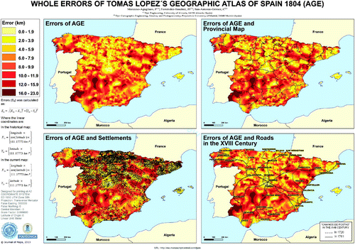
The results are summarized in , where 21,800 settlements of the Spain of 1804 were digitalized from the cartography of Tomas Lopez. The linkage was successful for 15,296 settlements, which means 75.23% of them. The lineal errors obtained are shown in , being the lowest error for Reynosa (2.82 km), the maximum error for La Mancha (11.29 km), and the average error (6.56 km) for the whole AGE.
, shows the spatial distribution of the lineal error of AGE in Spain. This map has been overlapped with the current provincial division of Spain to better identify the different geographical areas. Furthermore, the settlement locations that have been involved in the final analysis are shown over the map error, which shows that the highest density of settlements is mainly located in the yellow areas (less linear error). And finally a map of major communication road of that time ‘Caminos de Postas’ was overlapped with the error map. It is observed that the communication networks of that time run through corridors with lowest error, generally communicating less lineal error areas, either because they were more populated areas or because they run through surfaces of lower relief. As we can observe, the lowest error is due to the combination of higher density of settlements and proximity to the roads of that time ‘Caminos de Postas’.
Figure 1. Whole errors of Tomas Lopez's geographic atlas of Spain (1804).
5. Conclusions
The main conclusion of this work is that the lineal errors of AGE in Spain seem to be lower when the density of settlements is higher. With regard to the communication networks of that time ‘Caminos de Postas’, they run through corridors with lowest error, generally communicating less lineal error areas, leaving mountains and ridges with larger errors, due to their topography or the lower density of settlements. In short, the AGE designed by Tomas Lopez is a great cartography work, which represented a valuable contribution to the knowledge of the whole Spanish territory of his time; and his linear errors were very heterogeneous depending on the geographical area, density settlements and communication networks.
Software
The software used in this work is ArcGIS 10.
Acknowledgements
This study was funded by project HAR2009-12937 (GIS Systematic Analysis for the Planimetric Accuracy of the Geographic Atlas of Spain of Tomas Lopez, 1804), of the Spanish Ministry of Science and Innovation.
Main Map: Whole Errors of Tomas Lopez's Geographical Atlas of Spain 1804 (AGE)
Download PDF (1.2 MB)References
- Chias, P., & Abad, T. (2012). The art of describing the territory: Historic maps and plans of the bridge of Alcántara (Cáceres, España). Informes de la Construcion 64 (extra), 121–134.
- Harley , J. B. 1968 . The evaluation of early maps: Towards a methodology . Imago Mundi , 22 : 62 – 74 . (doi:10.1080/03085696808592318)
- Hu , B. 2010 . Application of geographic information systems (GIS) in the history of cartography . Proceedings of World Academy of Science, Engineering and Technology , 66 : 1562 – 1565 .
- Jenny , B. and Hurni , L. 2011 . Studying cartographic heritage: Analysis and visualization of geometric distortions . Computers & Graphics , 35 ( 2 ) : 402 – 411 . (doi:10.1016/j.cag.2011.01.005)
- Kardos , J. , Moore , A. and Benwell , G. 2005 . Exploring the hidden poTJOMial of common spatial data models to visualize uncertainty . Cartography and Geographic Information Science , 32 : 359 – 367 . (doi:10.1559/152304005775194827)
- Livieratos , E. 2006 . On the study of the geometric properties of historical cartographic representation . Cartographica , 4 : 165 – 175 . (doi:10.3138/RM86-3872-8942-61P4)
- Manzano-Agugliaro , F. , Martinez-García , J. and San-Antonio-Gómez , C. 2012 . GIS analysis of the accuracy of Tomas Lopeźs historical cartography in the Canary Islands (1742–1746) . Scientific Research and Essays , 7 ( 2 ) : 199 – 210 .
- Manzano-Agugliaro , F. , San-Antonio-Gómez , C. , López , S. , Montoya , F. G. and Gil , C. 2013 . Pareto-based evolutionary algorithms for the calculation of transformation parameters and accuracy assessment of historical maps . Computers and Geosciences , 57 : 124 – 132 . (doi:10.1016/j.cageo.2013.04.010)
- Plewe , B. S. 2003 . Representing datum-level uncertainty in historical GIS . Cartography and Geographic Information Science , 30 : 319 – 334 . (doi:10.1559/152304003322606229)
- Pontius , R. G. Jr. and Lippitt , C. D. 2006 . Can error explain map differences over time? . Cartography and Geographic Information Science , 33 : 159 – 171 . (doi:10.1559/152304006777681706)
- San-Antonio-Gómez , C. , Velilla , C. and Manzano-Agugliaro , F. 2011 . Tomas Lopez's geographic atlas of Spain in the Peninsular war: A methodology for determining errors . Survey Review , 43 ( 319 ) : 30 – 44 . (doi:10.1179/003962610X12747001420861)
- Tucci , M. and Giordano , A. 2011 . Positional accuracy, positional uncertainty, and feature change detection in historical maps: Results of an experiment . Computers, Environment and Urban Systems , 35 ( 6 ) : 452 – 463 . (doi:10.1016/j.compenvurbsys.2011.05.004)