Abstract
A high-resolution Digital Terrain Model (DTM) of Campi Flegrei caldera, obtained from an airborne LiDAR mission, has been analyzed in order to produce a 1:20,000-scale morphometric map of this volcanic area. The map consists of different thematic layers, which include: profile curvature, terrain ruggedness index, elevation range, as well as an up-to-date structural map and building distribution in the densely populated area. Results evidence that most of the relief is related to the occurrence of tuff-cones, tuff-ring, and the outer flanks of the caldera. Higher values of elevation characterize the upper portions of cones, while higher terrain ruggedness index values concentrate on the inner flanks of cones and in areas affected by gravity and erosional processes. The map also evidences the topographic expression of crater rims and of the major morphological scarps, which reflect ancient and uplifted shorelines and present-day cliffs.
1. Introduction
Development and interpretation of morphometric maps are important tools in studies related to neotectonics and geomorphology (CitationWright, Garbeil, Baloga, & Mouginis-Mark, 2006). In volcanic areas, important morphometric parameters include the elevation range, which gives information on the effective topography variations such as height of scarps and craters with respect to the surroundings and the terrain ruggedness index, which measures the terrain ‘rugosity’ and is a function of the type of deposit (e.g., lava flows, welded to loose pyroclastics) and erosion degree (CitationFornaciai, Bisson, Landi, Mazzarini, & Pareschi, 2010; CitationGrosse, van Wyk de Vries, Petrinovic, Euillades, & Alvarado, 2009). An additional parameter is profile curvature (CitationZevenbergen & Thorne, 1987), which measures the curvature in the vertical plane of a flow line, i.e. the terrain concavity or convexity. The higher and lower values of profile curvature usually identify the boundary of scarps and volcanic bodies like lava flows or the base and top of cones. Therefore, the construction of relief maps of volcanic terrain may furnish important data and information on the processes responsible for the relief construction and/or dismantling (CitationKarátson, Thouret, Moriya, & Lomoschitz, 1999).
The basic element for the direct extraction of geomorphological features is the digital terrain model (DTM). As high-resolution DTMs, for example derived from LiDAR (Light Detection and Ranging), become more readily available (CitationBuckley, Howell, Enge, & Kurz, 2008), there has been an improvement in the accuracy and reliability of the derived topographic indices. The geomorphological features of the Campi Flegrei active caldera (Italy) are, surprisingly, poorly known lacking previous quantitative studies on the landforms related to volcanic and/or erosive processes. With the aim to fill this gap, we present a morphometric map of the Campi Flegrei caldera using high-resolution airborne LiDAR data. The map could be useful for geological, structural, engineering geology studies, and urban and hazard management applications.
2. Geological setting
Campi Flegrei is an active and high-risk volcanic area located to the west of Naples, Southern Italy, inside the Campanian Plain. The Campi Flegrei caldera formed after the Campanian Ignimbrite (40 ka) and the Neapolitan Yellow Tuff eruptions (15 ka). In the last 15 ka, over 70 eruptions have been recognized and the last one occurred 1538 AD (Monte Nuovo eruption; ). The composition of the erupted products varies from shoshonites and latites to trachyte and trachyphonolite (CitationD'Antonio et al., 1999; CitationDi Vito et al., 1999). The post-15 ka volcanism concentrated in three main periods of activity: (a) from 15 to 9.2 ka, (b) from 8.5 to 8.2 ka, (c) from 5 ka to 1538 AD. (CitationDi Vito et al., 1999; CitationIsaia, Marianelli, & Sbrana, 2009; CitationOrsi, Di Vito, Selva, & Marzocchi, 2009). The Campi Flegrei plinian to strombolian and phreatomagmatic eruptions and deposits, along with subordinate extrusions of lava domes are responsible for the present-day geomorphological features of the area, which include large flat terrains and tuff-cones and tuff-rings affected by a different degree dismantling due to erosion by sea and gravity processes.
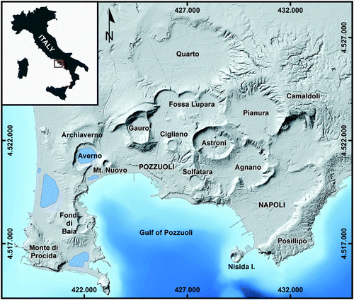
Figure 1. Shaded relief image of the (1 m × 1 m) DTM with location of the main volcanic cone (UTM WGS84 projection, distance in m).
NW-SE, NE-SW, and N-S striking faults occur at Campi Flegrei (CitationVilardo, Isaia, Ventura, De Martino, & Terranova, 2010). N-S and NW-SE eruptive fissures younger than 15 ka characterize the westernmost and eastern sectors, respectively. Fissures with a NW-SE strike occur in the central-eastern sector. N-S striking faults affect the central and westernmost sectors. Ground deformations due to bradyseism occurred during the last 2000 years. Two main, recent periods of unrest occurred in 1970–1972 and 1982–1984, with an uplift of 3.5 m between 1970 and 1984 followed by thousands of earthquakes and subsidence, which recovered only part of the displacement (<1 m). The slow and continuous subsidence is still ongoing with small amplitude uplift episodes (several centimetres), the last of which occurred in 2012. Landslides also affect different sectors of Campi Flegrei, mainly in the areas of higher topographic gradient.
3. Data and analytical methods
In this section the overall workflow to derive the relief map of the Campi Flegrei caldera is described in detail.
3.1. Lidar data and DTM production
The morphometric analysis is based on the processing of a very high-resolution airborne LiDAR data set acquired in 2009 by the Province of Naples council in the framework of the CECOSCA Project, aimed at the control of quarries using both aerial and satellite remotely sensed data.
The aerial LiDAR survey consists of several flight lines, side-lapped at 20–25%, aimed at longitudinally covering the whole Neapolitan Province area, with additional crossing flight lines to provide a dense coverage on the steep topography and to ensure at least 3 points per square meter with vertical and planimetric accuracy not exceeding 12 cm and 24 cm respectively.
After the acquisition phase, a bare earth model was generated from raw point clouds by removing data from low vegetation, as well as from trees and buildings affecting the scene (CitationAxelsson, 1999). Finally, the original bare-earth point cloud was used to interpolate a 1-m-grid Digital Terrain Model (DTM).
The DTM produced by the LiDAR height data consist of 16,000 × 17,000 grid cells. In order to simplify the relief analysis, the 1-m resolution LiDAR DTM was low pass filtered using a 5 × 5 averaging convolution kernel and then re-sampled to a 5-m grid cell size. The 5 by 5 m DTM, which is adequate to capture the scale of surface features (CitationVaze, Teng, & Spencer, 2010), was used to derive the following thematic maps: profile curvature (Kp), topographic ruggedness index (TRI) and elevation range (ER).
Profile curvature Kp has been estimated using the algorithm of CitationZevenbergen and Thorne (1987). The Topographic Ruggedness Index is the difference between the value of a cell and the mean of a 5 × 5 cell sub-matrix (e.g., CitationRiley, DeGloria, & Elliot, 1999). Elevation Range is the difference between the maximum and minimum altitudes of a 5 × 5 cell sub-matrix. The elevation range is proportional to the slope. These three parameters have been selected with the aim of obtaining a morphometric representation of the Campi Flegrei caldera in m (TRI and ER) or m−1 as measurement units. This allows the direct comparison of different topographic features useful for volcanological and structural studies as well as for urban and hazard management studies and engineering geology applications at 1: 20,000 scale.
3.2 Post-processing
In spite of the re-sampling of the 1 m resolution DTM to the coarser 5-m resolution, the spatial distribution of the previously described morphometric parameters was still influenced by small-scale terrain irregularities. In very high-resolution DTMs produced by LiDAR data, these abrupt spatial changes can be real landscape features or, more commonly, correspond to man-made features such as bridges, roads, railways and open quarries. With the aim of removing artifacts related to man-made constructions, as well as improving readability of the geomorphological map (CitationParon & Smith, 2008), the morphometric layers were post-processed by applying the following techniques.
Firstly, the complexity of the cartographic elements was reduced. Kp, TRI and ER maps were simplified using the following steps: (1) Reclassification of the raster thematic maps based on classes range values adequate in representing the terrain feature of interest (); (2) raster to vector polygon conversion and removal of features with surface areas smaller than defined threshold values. Different threshold values were used on the basis of the different degree of spatial fragmentation which affects the different thematic maps ().
Table 1. Bounding values used to reduce the complexity of the different thematic maps.
The resulting thematic polygon maps still contain line features related to man-made structures (roads, railways and open quarries). Since these features only affect developed areas, which, in turn, correspond to flat areas, polygons were removed in areas with slopes less than 5%.
The main map sheet accompanying this article titled “Morphometric map of the Campi Flegrei caldera (Southern Italy)” was completed by merging the results from our study with the up to date structural information available in the literature (CitationOrsi et al., 2009; CitationVilardo et al., 2010). In addition, in order to contextualize the obtained morphometric results in the urban fabric of this area characterized by high population density, the distribution of existing buildings was also added to the final map.
4. Results and conclusions
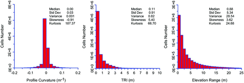
The morphometric map of Campi Flegrei shows that most of the relief in the area is related to the formation of the <15 ka tuff-rings and tuff-cones, which concentrate in the central sector of the caldera. High relief areas characterize the outer flanks of the caldera structure (Monte di Procida, Posillipo and Camaldoli areas). The elevation range values >1 m define the inner and outer flanks of the cones with the higher values generally concentrated in the upper portions, as expected on volcanoes (CitationVentura & Vilardo, 2006). The positive profile curvature values >0.017 delimit the crater floors, whereas the negative values <−0.017 define the crater rims. Closed areas of positive and negative values define the major scarps (e.g. uplifted paleo-coastlines and cliffs). The higher TRI values are concentrated on the inner flanks of the cones, where dismantling processes due to washing action concentrate, and, to a lesser degree, on the outer flanks. Also, the Camaldoli area, where no volcanic cones outcrop, is characterized by high TRI values. This area is affected by diffuse landslides and the relief is strictly controlled by gravity processes (CitationCalcaterra et al., 2007). The distribution of the values of the above defined three morphometric parameters in the Campi Flegrei DTM is shown in . The parameters show absolute maxima in frequency at values close to 0, which reflects the prevailing flat topography of the Campi Flegrei caldera (). The profile curvature distribution is skewed toward negative values, so suggesting a prevailing convex upward surface, which is typical of topographically depressed structures like calderas (CitationCole, Milner, & Spinks, 2005). In summary, the morphometric map of Campi Flegrei shows the areas characterized by recent (15 ka) volcanic processes, erosion phenomena due to the present-day and past activity of the sea, gravity and surface dismantling processes.
Figure 2. Distribution of the values of the selected morphometric parameters in the Campi Flegrei DTM.
Software
SAGA 2.0.5 (http://www.saga-gis.org/en/index.html) was utilized to perform analyses and extract morphological features from the DTM; ESRI ArcGIS 10.0 was utilized to post-process the thematic maps, as well as to design of the final map.
Main Map: Morphometric Map of the Campi Flegrei Caldera (Southern Italy)
Download PDF (22.8 MB)Acknowledgements
Thanks to the Sistema Informativo Territoriale, Assessorato Trasporti Viabilità Urbanistica of the Provincia di Napoli for providing the airborne LiDAR data used in this study. We thank the referees Carlos Grohmann, Lucian Dragut, and Jan-Christoph Otto for the useful comments. We also thank Mike Smith for the editorial handling.
Related Research Data
References
- Axelsson , P. 1999 . Processing of laser scanner data — Algorithms and applications . ISPRS Journal of Photogrammetry & Remote Sensing , 54 ( 2–3 ) : 138 – 147 . http://doi:10.1016/S0924-2716(99)00008-8 (doi:10.1016/S0924-2716(99)00008-8)
- Buckley , S. J. , Howell , J. , Enge , H. and Kurz , T . 2008 . Terrestrial laser scanning in geology: Data acquisition, processing and accuracy consideration . Geological Society of London Journal , 165 : 625 – 638 . http://doi:10.1144/0016-76492007-100 (doi:10.1144/0016-76492007-100)
- Calcaterra , D. , Coppin , D. , de Vita , S. , Di Vito , M. A. , Orsi , G. , Palma , B. and Parise , M. 2007 . Slope processes in weathered volcaniclastic deposits within the city of Naples: The Camaldoli Hill case . Geomorphology , 87 : 132 – 157 . http://doi:10.1016/j.geomorph.2006.03.040 (doi:10.1016/j.geomorph.2006.03.040)
- Cole , J. W. , Milner , D. M. and Spinks , K. D. 2005 . Calderas and caldera structures: a review . Earth-Science Rev. , 69 : 1 – 26 . http://doi:10.1016/j.earscirev.2004.06.004 (doi:10.1016/j.earscirev.2004.06.004)
- D'Antonio , M. , Civetta , L. , Orsi , G. , Pappalardo , L. , Piochi , M. , Carandente , A. , de Vita , S. , Di Vito , M. A. and Isaia , R. 1999 . The present state of the magmatic system of the Campi Flegrei caldera based on a reconstruction of its behavior in the past 12 ka . J. Volcanol. Geoth. Res. , 91 : 247 – 268 . http://doi:10.1016/S0377-0273(99)00038-4 (doi:10.1016/S0377-0273(99)00038-4)
- Di Vito , M. A. , Isaia , R. , Orsi , G. , Southon , J. , de Vita , S. , D'Antonio , M. , Pappalardo , L. and Piochi , M. 1999 . Volcanism and deformation since 12.000 years at the Campi Flegrei caldera (Italy) . J. Volcanol. Geoth. Res. , 91 : 221 – 246 . http://doi:10.1016/S0377-0273(99)00037-2 (doi:10.1016/S0377-0273(99)00037-2)
- Fornaciai , A. , Bisson , M. , Landi , P. , Mazzarini , F. and Pareschi , M. T. 2010 . A LiDAR survey of Stromboli volcano (Italy): Digital elevation model-based geomorphology and intensity analysis . International Journal of Remote Sensing , 31 ( 12 ) : 3177 – 3194 . doi: 10.1080/01431160903154416 (doi:10.1080/01431160903154416)
- Grosse , P. , van Wyk de Vries , B. , Petrinovic , I. , Euillades , P. A. and Alvarado , G. E. 2009 . Morphometry and evolution of arc volcanoes . Geology , 37 : 651 – 654 . http://doi:10.1130/G25734A.1 (doi:10.1130/G25734A.1)
- Isaia , R. , Marianelli , P. and Sbrana , A. 2009 . Caldera unrest prior to intense volcanism in Campi Flegrei (Italy) at 4.0 ka B.P.: implications for caldera dynamics and future eruptive scenarios . Geophys. Res. Lett. , 36 : L21303 http://doi:10.1029/2009GL040513 (doi:10.1029/2009GL040513)
- Karátson , D. , Thouret , J. -Cl. , Moriya , I. and Lomoschitz , A. 1999 . Erosion calderas: origins, processes, structural and climatic control . Bull. Volcanol. , 61 : 174 – 193 . (doi:10.1007/s004450050270)
- Orsi , G. , Di Vito , M. A. , Selva , J. and Marzocchi , W. 2009 . Long-term forecast of eruption style and size at Campi Flegrei caldera (Italy) . Earth Planet. Sci. Lett. , 287 : 265 – 276 . http://doi:10.1016/j.epsl.2009.08.013 (doi:10.1016/j.epsl.2009.08.013)
- Paron , P. and Smith , M. J. 2008 . Editorial: Applied geomorphological mapping . Journal of Maps , 4 ( 1 ) : 197 – 200 . http://doi:10.4113/jom.2008.1048 (doi:10.4113/jom.2008.1048)
- Riley , S. J. , DeGloria , S. D. and Elliot , R. 1999 . A terrain ruggedness index that quantifies topographic heterogeneity . Intermountain Journal of Sciences , 5 ( 1–4 ) : 23 – 27 .
- Vaze , J. , Teng , J. and Spencer , G. 2010 . Impact of DEM accuracy and resolution on topographic indices . Environmental Modelling & Software , 25 : 1086 – 1098 . http://doi:10.1016/j.envsoft.2010.03.014 (doi:10.1016/j.envsoft.2010.03.014)
- Ventura , G. and Vilardo , G. 2006 . Tomomorphometry of the Somma-Vesuvius volcano (Italy . Geophys. Res. Lett. , 33 : H7305 http://doi:10.1029/2006GL027116 (doi:10.1029/2006GL027116)
- Vilardo , G. , Isaia , R. , Ventura , G. , De Martino , P. and Terranova , C. 2010 . InSAR Permanent Scatterer analysis reveals fault reactivation during inflation and deflation episodes at Campi Flegrei caldera . Remote Sensing of Environment , 114 : 2373 – 2383 . http://doi:10.1016/j.rse.2010.05.014 (doi:10.1016/j.rse.2010.05.014)
- Wright , R. , Garbeil , H. , Baloga , S. M. and Mouginis-Mark , P. J. 2006 . An assessment of shuttle radar topography mission digital elevation data for studies of volcano morphology . Remote Sensing of Environment , 105 : 41 – 53 . http://doi:10.1016/j.rse.2006.06.002 (doi:10.1016/j.rse.2006.06.002)
- Zevenbergen , L. W. and Thorne , C. R. 1987 . Quantitative analysis of the land surface topography . Earth Surface Processes and Landforms , 12 : 47 – 56 . http://doi:10.1002/esp.3290120107 (doi:10.1002/esp.3290120107)