
Abstract
The Mejillones Peninsula (northern Chile) has undergone a complex tectono-sedimentary history from the Miocene onward and is dissected by a network of normal faults that generated three asymmetric half-grabens located in a forearc position with respect to the Chile subduction system. A new 1:50,000-scale geological map of the peninsula, covering an area of ca 800 km2 and based on a detailed facies analysis and field mapping (1:20,000 scale) in conjunction with a comprehensive interpretation of aerial photographs (1:33,000 scale), gives new and updated information about the nature of marine sedimentation and deformation during the Miocene to Pleistocene and permits the geological history of the peninsula during this time period to be reconstructed. An important aspect of organising the Miocene to Pleistocene stratigraphy has been the recognition of three regional allostratigraphic units in the hangingwall basin-fill sediments (the Miocene Caleta Herradura, Pliocene La Portada, and Pleistocene Mejillones alloformations) and two major morphostratigraphic units (PlioMMU and PleiMMU) including extensive flights of Pliocene and Pleistocene marine terraces carved on crestal and flanking areas of adjacent footwall blocks.
1. Introduction
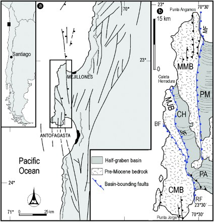
The Mejillones Peninsula forms a morphological landmark of the northern Chilean coastline (). It is located about 60 km east of the Peru-Chile subduction zone and stretches from Punta Angamos to the north (S23°01′30″) to Punta Jorge to the south (S23°32′30″). Due to subcrustal accretion of material removed at the trench by subduction erosion, this area has been experiencing east-west extension since the early Miocene (e.g., CitationArmijo & Thiele, 1990; CitationClift & Hartley, 2007; CitationDelouis, Philip, Dorbath, & Cisternas, 1998; CitationHartley et al., 2000; Citationvon Huene, Weinrebe, & Heeren, 1999; Citationvon Huene & Ranero, 2003) and both extension and uplift since the Pliocene (CitationVictor, Sobiesiak, Glodny, Nielsen, & Oncken, 2011). Extension has resulted in the formation of three main half-grabens (Caleta Herradura, Pampa de Mejillones, and Pampa del Aeropuerto basins, see the map for their location) bounded by north- to north-northwest–striking, east-dipping, listric normal faults (Jorgino, Mejillones, & La Rinconada faults), whereas uplift has favoured the development of extensive flights of marine terraces and onland exposure of Miocene to Pleistocene shallow-marine sediments infilling major hangingwall basins. Quaternary uplift rates, calculated by CitationDelouis et al. (1998) near the Mejillones Peninsula and Antofagasta, range from 0.05 to 0.5 mm/a.
Figure 1. Map of the Mejillones Peninsula. (a) Regional tectonic setting after CitationNiemeyer, González, & Martínez-de Los Ríos (1996). (b) Geology adapted from CitationArmijo and Thiele (1990); MMB, Morro Mejillones Block; MF, Mejillones Fault; PM, Pampa Mejillones basin; MJB, Morro Jorgino Block; JF, Jorgino Fault; CH, Caleta Herradura basin; CMB, Cerro Moreno Block; RF, La Rinconada Fault; PA, Pampa del Aeropuerto basin.
The aim of the map presented here is to synthesise the results of a multiyear field study of the Mejillones Peninsula, which allowed the development of an allostratigraphic and morphostratigraphic framework for interpreting its geological evolution during the Miocene to Pleistocene time interval. The map builds on various seasons of field survey undertaken during the 2003, 2004, 2006 and 2012, which involved geological mapping and integrated stratigraphic, sedimentologic, and geomorphological analyses.
2. Methodology
The 1:50,000-scale geological map of the Miocene-Pleistocene successions exposed in the Mejillones Peninsula encompasses an area of roughly 800 km2 that was originally mapped at the 1:20,000 scale using enlarged 1:50,000 scale topographic maps superimposed over georeferenced and enlarged 1:33,000 scale aerial photographs. In order to define the allostratigraphic architecture and provide new insights into the Miocene to Pleistocene geological evolution of the peninsula, detailed field mapping and stratigraphic analysis aiding in the recognition of unconformable boundaries have been carried out (CitationNACSN, 2005). Three regional erosive surfaces, having the character of angular unconformities and readily recognisable in the field based on facies shifts and biostratigraphic data, have been used as bounding surfaces of alloformations. A detailed geomorphologic and morphostratigraphic investigation based on integrated field observations and stereoscopic aerial photo interpretation revealed the occurrence of a number of well-preserved marine terraces. Across most of the Mejillones Peninsula, these landforms consist of strath surfaces overlain by thin (mostly < 1 m), isolated patches of shallow-marine sediments. Because of the discontinuous distribution of the sediment cover, a morphostratigraphical approach has been used to describe these staircased planar landforms. As a result, they have been grouped to form two major morphostratigraphic units (namely PlioMMU and PleiMMU) of Pliocene and Pleistocene age, respectively. These morphostratigraphic units, mapping units identified primarily from the surface form they display (CitationHughes, 2013), are separated by a pronounced palaeo sea-cliff (up to about 100 m in height).
The distribution and correlation of marine terraces and the position of their outer and inner edges (strandlines) have been determined primarily on geomorphological grounds, using aerial photographic interpretation and on-site inspections. The exact altitude of both the outer and inner edges of each identifiable terrace, which was recorded by walking shore-perpendicular transects using a high-precision aneroid altimeter (limit reading ±1 m), is probably accurate to within 2–3 m. When no outer edge bedrock was available, a rough estimate of sediment cover was subtracted from the altimeter elevation, in order to give a tentative inner edge bedrock elevation.
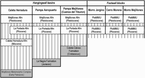
3. Allostratigraphic and morphostratigraphic units
The Cenozoic stratigraphic record exposed in the Mejillones Peninsula records two discrete stages in the tectonostratigraphic development of the area (CitationCantalamessa, Di Celma, Ragaini, Valleri, & Landini, 2005). The pre-extensional sedimentary record is represented by Oligocene to early Miocene continental conglomerate (Cerro Moreno Conglomerate alloformation), whereas the syn-extensional Miocene to Pleistocene stratigraphic record () comprises three unconformity-bounded alloformations (Caleta Herradura, La Portada, and Mejillones alloformations) and two major morphostratigraphic units (PlioMMU and PleiMMU). These units sit unconformably on a complex pre-Cenozoic bedrock (CitationCortés, Marquardt, González, Wilke, & Marinovic, 2007) including Paleozoic metamorphic rocks (Mejillones Metamorphic Complex), Jurassic volcanic rocks (La Negra Formation), and Lower Cretaceous sediments (Caleta Coloso Formation). Since it does not represent the topic of this geological map, the pre-Cenozoic bedrock has not been differentiated.
Figure 2. Schematic stratigraphic chart summarising the main miocene to pleistocene allostratigraphic and morphostratigraphic units exposed in the mejillones peninsula.
3.1. Pre-extensional unit
Cerro Moreno Conglomerate (CMC Afm). Exposures of this unit are restricted to two small outcrops on the northern flank of Cerro Moreno where it is composed of well-rounded, matrix-supported continental conglomerates resting unconformably on Paleozoic metamorphic rocks of the Mejillones Metamorphic Complex. CitationNiemeyer et al. (1996) correlated these sediments with those of the Gravas Colgadas Unit exposed on the Cordillera de la Costa.
3.2. Syn-extensional units
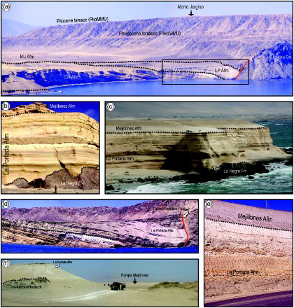
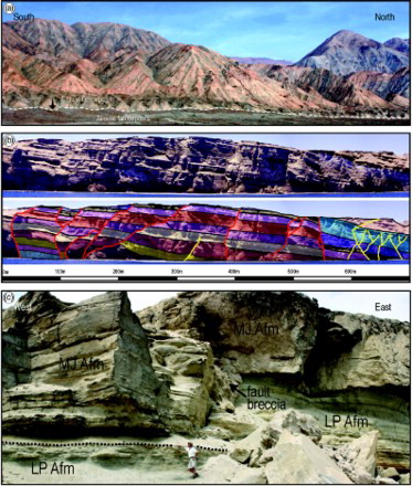
Caleta Herradura Alloformation (CH Afm). This unit is spectacularly exposed at Caleta Herradura de Mejillones ((b)), a high lunate sea-cliff at the northern end of the Caleta Herradura basin ((a)). At this site, the 380 m-thick CH Afm displays a faulted, westerly dipping monoclinal geometry and is interposed between the Mejillones Metamorphic Complex below and sediments of the La Portada and Mejillones Afms above. According to CitationKrebs, Aleman, Padilla, Rosenfeld, and Niemeyer (1992) this predominantly shallow-marine, sand-rich succession consists, in ascending order, of five main lithofacies: (1) a lower package of reddish calcareous sandstone, massive shelly sandstone and some breccia (CitationCantalamessa & Di Celma, 2005); (2) thick beds of fossil debris interbedded with planar, cross-stratified coarse-grained sandstones, (3) fossiliferous mudstone interbedded with cross-bedded sandstone and fossiliferous conglomerate; (4) fine-grained, highly burrowed sandstones interbedded with cross-bedded sandstones; (5) medium-to-dark brown, silty diatomaceous mudstone interbedded with white laminated diatomite. Moving down the hangingwall, strata of this unit display a fanning of dips with the oldest beds having the steepest dips and form a divergent wedge that thickens into the fault, producing stratal geometry typical of progressive rotation during deposition. Accumulation of about 380 m of sediments in a shallow-marine setting indicates that throughout much of the basin history, sedimentation broadly matched subsidence until basin eversion occurred by smooth and rapid uplift. Complete exposure allows for recognition of a number of distinct and laterally persistent intraformational erosional surfaces that permit the identification of 25 metre to tens of metres-scale depositional sequences generated in response to high-frequency eustatic changes in sea level (CitationDi Celma & Cantalamessa, 2007).
Figure 3. (a) Aerial view over the north-facing Caleta Herradura de Mejillones section where the wedge-shaped, Miocene to Pleistocene clastic infill of the Caleta Herradura half-graben is spectacularly exposed. The basin fill is composed of three major unconformity-bounded units: the Miocene CH Afm, the Pliocene LP Afm and the Pleistocene MJ Afm. The basin is bounded to the west by the listric, steeply dipping Caleta Herradura Fault. In the background, flat surfaces on the crestal and flanking areas of the Morro Jorgino footwall block represent marine terraces of Pliocene and Pleistocene age, respectively. The dotted lines indicate unconformity surfaces. The black box is enlarged in d); (b-c) Exposure of Plio-Pleistocene shallow-marine strata at La Portada, southern end of Pampa del Aeropuerto. Note the highly irregular, non-conformable contact between the Jurassic La Negra Fm and the Pliocene LP Afm in the lower half of (b) and the sharp, erosional contact (dotted black line) of the MJ Afm on top of LP Afm; (d) enlargement of (a) (black box) showing the angular unconformity that separates the CH Afm below from the Pliocene LP Afm above and the strongly asymmetric syncline, possibly induced by normal drag against the fault, in the immediate hangingwall of the Caleta Herradura Fault; (e) road cut photo of the LP Afm and the overlying MJ Afm at Mejillones; (f) photograph showing the contact between the dark coloured pre-Miocene bedrock and the sediments of the LP Afm on the upthrown Morro Mejillones block, about 3 km northwest of Cuenca del Tiburon. The contact (dotted line) is characterised by low mounds that suggest a rugged topography of the substrate.
Evidence from the calcareous nannoplankton (CitationMai, 1984), the faunal composition of the diatomite at the top of the CH Afm (CitationKrebs et al., 1992), and from the planktonic foraminiferal content of the entire unit (CitationIbaraki, 2001), indicate that these strata span from late early to latest Miocene.
La Portada Alloformation (LP Afm). In the Mejillones Peninsula the Pliocene sedimentary record is rich in diatomaceous mud and diatomite. An exception to this is the La Portada section, a sea-cliff at the western side of Moreno Bay, where the LP Afm consists of 40 m of shallow-marine sandstone interbedded with Balanus-bearing coquina limestone that unconformably overlies the andesitic lavas of the La Negra Formation ((b) and 1(c)). At Caleta Herradura de Mejillones, sediments of the LP Afm are up to about 100 m thick; they rest unconformably on sediments of the CH Afm and are themselves truncated by Pleistocene deposits of the Mejillones Afm. At this site, this unit occurs within a 250 m-wide belt adjacent to the basin-bounding Caleta Herradura Fault (a north-striking splay of the Jorgino Fault) and comprises a diverse suite of footwall-derived non-marine conglomerate and breccia that interfinger to the east with burrowed, shallow-marine sandstone and conglomerate, and minor amounts of diatomite ((d)). At the northern extremity of the Pampa Mejillones basin, about 7 km immediately to the northeast of the town of Mejillones, a new road cut made for the construction of the new port has recently exposed sediments of this unit dominated by weakly stratified silty clay, massive diatomite and diatomaceous siltstone with occasional intercalations of well-sorted fine sand ((e)). At the southern end of the Pampa Mejillones basin (Cuenca del Tiburón) and in the southern portion of the Caleta Herradura basin the LP Afm is a mosaic of coarse bioclastic sandstone, whitish diatomite siltstone with frequent intercalations of silty layers of a buff colour and, to a significantly lesser extent, conglomerate and lenses of gypsum. At Cuenca del Tiburón, this alloformation crops out both at the footwall and hangingwall of the basin-bounding Mejillones fault and lies directly on the pre-Miocene bedrock ((f)).
Based on planktic foraminiferal biostratigraphy (CitationIbaraki, 2002; CitationTsuchi et al., 1988), sediments of this unit have been generally assigned to the Pliocene age. Throughout the peninsula, they contain dense faunal assemblages in which molluscs exclusive to, or characteristic of, Pliocene deposits coexist with surprisingly abundant and varied populations of warm-water species (CitationRagaini, Di Celma, & Cantalamessa, 2008), most of which have their current southern zoogeographical limit at 6°S (thermally anomalous molluscan assemblages of CitationOrtlieb, Díaz, & Guzmán, 1996).
Mejillones Alloformation (MJ Afm). The Pleistocene Mejillones Afm is bounded at the base by a basin-scale erosional surface having the character of a gentle angular unconformity and at the top by the present-day land surface. This unit, consisting of coarse-grained, richly fossiliferous, poorly consolidated sediments, includes three sequences of shingled, W-E-trending, arcuate beach ridge deposits preserved at the hangingwall of the basin-bounding faults ((a)). They record the position of the palaeoshoreline during relative sea-level fall and are easily discernible on aerial photographs. Each of the three beach ridge sequences can be subdivided in to a series of sets, which are separated from each other by poorly pronounced fossil sea-cliffs or major lateral discontinuities in beach ridge geometry and were most probably formed during succeeding oxygen isotope stages within former embayments (CitationCantalamessa, Di Celma, & Ragaini, 2006a; CitationOrtlieb et al., 1996). The arcuate, concave-to-the-sea shape of these regressive shorelines indicates that during the Pleistocene the sea abandoned the land away from the central part of the peninsula towards the north in the Pampa Mejillones and Caleta Herradura basins, and towards the south in the Pampa del Aeropuerto basin. This geometry, combined with the presence of a well-preserved, W-E-trending paleo-sea cliff at the landward end of the MJ Afm in the Pampa del Aeropuerto basin, indicates that during the Pleistocene the central part of the peninsula was subaerially exposed.
Figure 4. Field photographs showing (a) a series of marine terraces (PleiMMU) carved on the bedrock (white arrows) that pass into extensive sets of beach ridges (Mj Afm, red arrows) in the Caleta Herradura half-graben (in the background, marked by black arrows, the PlioMMU terraces); (b) Pliocene and Pleistocene terraces (black and white arrows, respectively) at Morro Mejillones, northern end of the Mejillones Peninsula. The San Luciano fault is a normal fault that downthrows the rocks to the west (i.e., to the right in the figure); (c) Pleistocene marine terrace (white arrow) partly hidden by alluvial fan deposits shed from the Morro Mejillones footwall block (El Rincon, Mejillones Bay, encircled person for scale in the lower left side); (d) the staircase-morphology formed by the flight of Pleistocene terraces (PleiMMU) at Rada de Abtao (the inner margin of the terraces are highlighted by the dashed black lines). In the background (upper left-hand side) the high palaeo sea-cliff is cut by the Pliocene terraces (PlioMMU) on the top of the Morro Mejillones footwall block (black arrow).
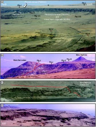
Pliocene major morphostratigraphic unit (PlioMMU). Remnants of three prominent marine terraces corresponding to PlioMMU were mapped only near the crest of the footwall blocks ((b)). The faunal content of the associated deposits (CitationNielsen, 2013) and geochronological data obtained from mollusc shells (CitationVictor et al., 2011) and volcanic ash layers (CitationMarquardt et al., 2005) indicate that they were cut during the Pliocene and, as such, they are broadly equivalent to the LP Afm. These terraces lie at elevations that vary between 350 m and 600 m a.s.l. at Morro Mejillones and between 200 m and 400 m a.s.l. at Cuenca del Tiburon (Morro Mejillones footwall block), between 350 m and 400 m a.s.l. at Morro Jorgino, 400 m and 450 m a.s.l. at Cerro Bandurria, and between 170 m and 220 m a.s.l. at Cerro Moreno. Displacement by normal faulting is responsible for the differences of these elevation ranges.
Pleistocene major morphostratigraphic unit (PleiMMU). Detailed examination of aerial photographs reveals the existence of a series of raised marine terraces cut into the flanks of footwall blocks and extending from a few metres to elevations of more than 300 m. These elevated wave cut platforms result from a combination of glacio-eustatic sea-level fluctuation and tectonic uplift (CitationHartley & Jolley, 1995) and, based on palaeontological evidence and geochronological data obtained from mollusc shells at several sites, they are considered to be of Pleistocene age (e.g., CitationCantalamessa, Di Celma, Ragaini, Valleri, & Landini, 2004; CitationOrtlieb et al., 1996; CitationRadtke, 1987; CitationRatusny & Radtke, 1988). As such, they are largely equivalent in age to the MJ Afm and have been grouped to form the youngest major morphostratigraphic unit (PleiMMU). As a rule, an individual terrace consists of a subhorizontal or gently seaward dipping wave-cut surface that is terminated landward by an ancient sea cliff up to about 15 m high and may be devoid of marine cover or may be overlain by a thin section of poorly cemented, unsorted marine sand and gravel containing pebbles and boulders. Locally, these marine features are overlain by alluvial fan deposits that, owing to their thickness, may lead to a complete burial of fossil cliffs and strandlines ((c)). The best developed set of such uplifted terraces occurs as a broad flight at the northwest corner of the peninsula, between Rada de Abtao and Punta Loberia ((d)), where up to thirteen marine terraces can be distinguished. Terrace elevations correlated with a composite sea-level curve indicates that the uplift rate markedly decreased towards the present since at least the Middle Pleistocene (CitationCantalamessa et al., 2004; CitationLiermann et al., 2013).
4. Tectonic features
4.1. Map-scale tectonic features
The major normal faults occurring within the Mejillones Peninsula have already been described by CitationArmijo and Thiele (1990), CitationNiemeyer et al. (1996), and CitationAllmendinger and González (2010). Three N–S and NNW–SSE striking, eastward dipping, large-displacement faults can be recognised; from west to east, the Jorgino, La Rinconada, and Mejillones faults (). These faults are 20–30 km in length and display morphological evidence of recent activity (e.g., CitationCortés et al., 2012), with fault scarps offsetting late Pleistocene to Holocene footwall-derived alluvial fans ((a)). In general, they have a listric geometry, displaying gentle rollover anticlines in the hangingwalls and unrotated footwalls (CitationAllmendinger & González, 2010).
Figure 5. Geological cross sections. See the map for the location of each section.
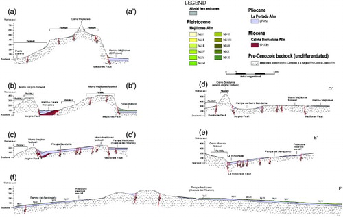
Figure 6. (a) Westward view of the north-south striking Mejillones Fault at Pampa Mejillones, 3 km south of El Rincon. The trace of the fault scarp is marked by black arrows; (b) photograph (above) and line drawing (below) of an outcrop view of the Caleta Herradura de Mejillones section showing two related but distinct systems of extensional faults dissecting the infill of the hangingwall basins: a blind system active during deposition of the CH Afm (yellow) and a surface-breaking system (red) that cut sediments of the CH Afm with large vertical displacements but do not significantly offset sediments of the overlying MJ Afm, revealing that most of the faulting took place after deposition of the CH Afm and prior to deposition of the MJ Afm; (c) outcrop photo of a small-displacement, down-to the west normal fault at La Portada. The base of the Pleistocene MJ Afm (dotted line) is downthrown about 5 m.
Subsidence and uplift vary along strike and are associated with variation in fault displacement, from maxima at fault centres to minima at fault tips. The Mejillones Fault shows a cumulative displacement of more than 400 m in the north (Mejillones) that decreases progressively southward towards the tip point (just south of Cuenca del Tiburon). The vertical displacement of the La Rinconada Fault increases southward, towards the Antofagasta Bay, whereas at its northern termination this fault is part of a complex transfer structure including a basin and a step over the southward propagating Jorgino Fault (González et al., 2003; CitationVictor et al., 2011).
4.2. Mesoscale tectonic features
The half-graben fills are dissected by two secondary systems of normal faults that are subparallel to the master faults ((b)) and may be interpreted as extensional faults related to the bending of the hangingwall during movements along the basin-bounding faults (CitationWithjack, Islam, & La Pointe, 1995). The old system is well-exposed at Caleta Herradura de Mejillones, where it consists of blind, upward-propagating faults that exhibit normal separation at depth and fade out into the younger strata upsection, indicating that the major propagation of this system commenced and ceased during the middle and late Miocene. The other system is dominated by closely spaced, NW–SE and NNW–SSE striking, synthetic and antithetic normal faults. At Caleta Herradura de Mejillones, the Miocene succession does not show evidence of abrupt changes in thickness on the two sides of these faults, which are generally planar, steeply dipping and have displacements of up to ∼50 m (CitationDi Celma & Cantalamessa, 2007). The fault scarps also cut across the overlying Pleistocene Mejillones Afm but in this case the offset of the beach ridge deposits is a few metres at most. Vertical variation in displacement across the unconformity surface at the base of MJ Afm and lack of differential vertical displacements between marker beds in CH Afm suggest that this fault system post-dates deposition of the CH Afm and probably propagated during the Quaternary, as did those described at Pampa de Mejillones and at Pampa del Aeropuerto ((c)) by CitationArmijo and Thiele (1990) and CitationCantalamessa et al. (2006a).
5. Conclusions: Miocene to Pleistocene Evolution of the Mejillones Peninsula
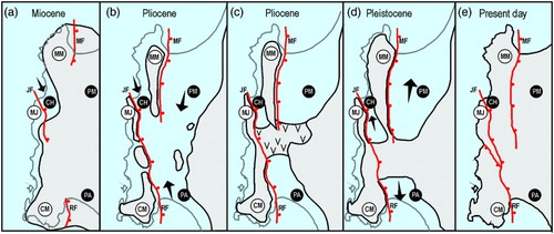
Integrated stratigraphic and structural analyses provided insights into the Miocene to Pleistocene evolution of the tectonically controlled palaeogeography and sedimentation pattern in the Mejillones Peninsula. Our field data show that marine sedimentation initiated during the Miocene and was initially restricted to the Caleta Herradura half-graben, a narrow and elongate hangingwall depocentre on the northwestern margin of the peninsula ((a)). Lateral fault propagation continued throughout the Pliocene, resulting in development of three half-grabens and widespread shallow-marine sedimentation both on the footwall (PlioMMU) and hangingwall (LP Afm) of the basin-bounding faults. At this time, propagation and linkage of the adjacent Jorgino and La Rinconada faults led to coalescence of early fault depocentres and the Cerro Moreno, Cerro Bandurrias, and Morro Mejillones fault blocks formed footwall islands ((b)). Periodic accretion of coastal barriers and dunes may have progressively restricted open marine circulation in the central portion of the Mejillones Peninsula, resulting in gypsum precipitation in coastal lagoons ((c)). During the Pleistocene ((d)) the central portion of the peninsula started uplifting above sea-level (CitationCantalamessa, Di Celma, Ragaini, Valleri, & Landini, 2006b; CitationVictor et al., 2011) and both the Cerro Bandurrias-Cerro Moreno and Morro Mejillones footwalls became attached to the mainland, giving rise to two elongate peninsulas. At this time, a series of marine terraces (PleiMMU) and sequences of regressive beach ridges (MJ Afm) were formed in footwall and hangingwall areas, respectively. Due to regional uplift, both the footwall and hangingwall of the basin-bounding faults were uplifted and spectacularly exposed onland ((e)). The latter, because of hangingwall subsidence, at rates lower than those of the former (CitationCantalamessa et al., 2004).
Figure 7. Schematic palaeogeographical maps illustrating the Miocene to Pleistocene history of the Mejillones Peninsula (see text for explanation). MM, Morro Mejillones Block; MF, Mejillones Fault; PM, Pampa Mejillones basin; MJ, Morro Jorgino Block; JF, Jorgino Fault; CH, Caleta Herradura Basin; CM, Cerro Moreno Block; RF, La Rinconada Fault; PA, Pampa del Aeropuerto basin.
Software
The geological map and associated geological sections were compiled by scanning hand drafts as black and white TIF files, and then digitising the linework using Corel Draw X3.
Main Map: Geological Map of the Miocene-Pleistocene Successions of the Mejillones Peninsula, Northern Chile
Download PDF (2.9 MB)Acknowledgements
The present paper forms part of the post-doctoral research of one of the authors (CDC) and arises from a research project funded by the Italian Ministry of University and Scientific Research (Prof. G. Cantalamessa). Andrea Baggio and Luca Ragaini are thanked for assisting with field work. Journal reviewers Pierluigi Pieruccini, Chandra Jayasuriya, Pia Victor and Associate Editor Ken Tanaka are gratefully acknowledged for their thoughtful contribution and helpful criticism that sharpened the focus of this study.
Related Research Data
References
- Allmendinger, R. W., & González, G. (2010). Neogene to quaternary tectonics of the coastal Cordillera, northern Chile. Tectonophysics, 495, 93–110, doi:10.1016/j.tecto.2009.04.019 doi: 10.1016/j.tecto.2009.04.019
- Armijo, R., & Thiele, R. (1990). Active faulting in northern Chile: Ramp stacking and lateral decoupling along a subduction plate boundary? Earth and Planetary Science Letters, 98, 40–61. doi:10.1016/0012-821X(90)90087-E. doi: 10.1016/0012-821X(90)90087-E
- Cantalamessa, G., & Di Celma, C. (2005). Sedimentary features of tsunami backwash deposits in a shallow marine Miocene setting, Mejillones Peninsula, northern Chile. Sedimentary Geology, 178, 259–273. doi:10.1016/j.sedgeo.2005.05.007 doi: 10.1016/j.sedgeo.2005.05.007
- Cantalamessa, G., Di Celma, C., & Ragaini, L. (2006a). Tectonic controls on sequence stacking pattern and along-strike architecture in the Pleistocene Mejillones Formation, northern Chile: Implications for sequence stratigraphic models. Sedimentary Geology, 183, 125–144. doi:10.1016/j.sedgeo.2005.09.010 doi: 10.1016/j.sedgeo.2005.09.010
- Cantalamessa, G., Di Celma, C., Ragaini, L., Valleri, G., & Landini, W. (2004). Pleistocene vertical movements in the Mejillones Peninsula (northern Chile) and mollusc content of marine terraces, 2nd GeoSed Conference, Rome (Italy) 22-28 September 2004, Abstract book, 42–46.
- Cantalamessa, G., Di Celma, C., Ragaini, L., Valleri, G., & Landini, W. (2005). Neogene stratigraphic architecture and tectonic evolution of the Mejillones Peninsula (northern Chile) based on a new 1:50,000 geological map. 6th International Symposium on Andean Geodynamics, Barcelona, Extended Abstracts, 142-145.
- Cantalamessa, G., Di Celma, C., Ragaini, L., Valleri, G., & Landini, W. (2006b). The Neogene stratigraphic and paleogeographic evolution of the Mejillones Peninsula (northern Chile) and its relationship with long-term, subduction-related extensional tectonics, “Backbone of the Americas-Patagonia to Alaska”, Geological Society of America Specialty Meetings, Mendoza (Argentina) 3-7 April 2006, Abstract with Programs 5–32, 64.
- Clift, P. D., & Hartley, A. J. (2007). Slow rates of subduction erosion and coastal underplating along the Andean margin of Chile and Peru. Geology, 35, 503–506. doi: 10.1130/G23584A.1.
- Cortés, J., Marquardt, C., González, G., Wilke, H.-G., & Marinovic, N. (2007). Cartas Mejillones y Península de Mejillones, Región de Antofagasta, Servicio Nacional de Geología y Minería, Carta Geológica de Chile, Serie Geología Básica, 103 and 104, 58 p., 1 mapa escala 1:100.000, Santiago, Chile.
- Cortés, J. A., González, G. L., Binnie, S. A., Robinson, R., Freeman, S. P. H. T., & Vargas, G. E. (2012). Paleoseismology of the Mejillones Fault, northern Chile: Insights from cosmogenic 10Be and optically stimulated luminescence determinations. Tectonics, 31, TC2017. doi:10.1029/2011TC002877 doi: 10.1029/2011TC002877
- Delouis, B., Philip, H., Dorbath, L., & Cisternas, A. (1998). Recent crustal deformation in the Antofagasta region (northern Chile) and the subduction process. Geophysical Journal International, 132, 302–338. doi: 10.1046/j.1365-246x.1998.00439.x.
- Di Celma, C., & Cantalamessa, G. (2007). Sedimentology and high-frequency sequence stratigraphy of a forearc extensional basin: The Miocene Caleta Herradura Formation, Mejillones Peninsula, northern Chile. Sedimentary Geology, 198, 29–52. doi:10.1016/j.sedgeo.2006.11.003 doi: 10.1016/j.sedgeo.2006.11.003
- González, G., Cembrano, J., Carrizo, D., Macci, A., & Schneider, H. (2003). The link between forearc tectonics and Pliocene-Quaternary deformation of the Coastal Cordillera, northern Chile. Journal of South American earth Sciences, 16, 321–342. doi: 10.1016/S0895-9811(03)00100-7.
- Hartley, A. J., & Jolley, E. J. (1995). Tectonic implications of Late Cenozoic sedimentation from the Coastal Cordillera of northern Chile (22-24°S). Journal of the Geological Society, London, 152, 51–63. doi:10.1144/gsjgs.152.1.0051 doi: 10.1144/gsjgs.152.1.0051
- Hartley, A. J., May, G., Chong, G., Turner, P., Kape, S. J., & Jolley, E. J. (2000). Development of a continental forearc: A Cenozoic example from the Central Andes, northern Chile. Geology, 28, 331–334. doi: 10.1130/0091-7613(2000)28<331:DOACFA>2.0.CO;2
- von Huene, R., & Ranero, C. R. (2003). Subduction erosion and basal friction along the sediment-starved convergent margin off Antofagasta, Chile. Journal of Geophysical Research, 108(B2), 2079, doi: 10.1029/2001JB001569.
- von Huene, R., Weinrebe, W., & Heeren, F. (1999). Subduction erosion along the north Chile margin. Journal of Geodynamics, 27, 345–358, doi:10.1016/S0264-3707(98)00002-7. doi: 10.1016/S0264-3707(98)00002-7
- Hughes, P. D. (2013). Morphostratigraphy-Allostratigraphy. In Elias S. (Ed.), Encyclopedia of Quaternary sciences (pp. 2841–2847). Amsterdam: Elsevier.
- Ibaraki, M. (2001). Neogene planktonic foraminifera of the Caleta Herradura de Mejillones section in northern Chile: Biostratigraphy and paleoceanographic implications. Micropaleontology, 47, 257–267. doi:10.2113/47.3.257 doi: 10.2113/47.3.257
- Ibaraki, M. (2002). Neogene planktonic foraminifera on the Pacific coast of South America (Unpublished Ph.D. thesis). Shizuoka University, Shizuoka, Japan, 101 pp.
- Krebs, W. N., Aleman, A. M., Padilla, H., Rosenfeld, J. H., & Niemeyer, H. (1992). Age and paleoceanographic significance of the Caleta Herradura diatomite, Peninsula de Mejillones, Antofagasta, Chile, Revista Geológica de Chile, 19, 75–81.
- Liermann, A., Dunai, T., Binnie, S., Heinze, S., Dewald, A., Victor, P., & González, G. (2013). New terrace ages better constrain the uplift history for the Mejillones Peninsula, northern Chile, Geophysical Research Abstracts, 15, EGU2013-6304.
- Mai, H. (1984). Nannoplancton calcareo neogeno de la formacion La Portada, Caleta Herradura, Peninsula de Mejillones, region de Antofagasta, Chile. Revista Geológica de Chile, 22, 17–24.
- Marquardt, C., Fomari, M., Lavenu, A., Vargas, G., Ortlieb, L., Ritz, J. F., Philip, H., & Marinovic, N. (2005). Volcanic ash dating from the Mejillones Peninsula (23°S): Implications for the Neogene outer fore-arc stratigraphy, tectonics and volcanic relationships, 6th International Symposium of Andean Geodynamics, Barcelona, Extended Abstracts, 477–480.
- NACSN. (2005). North American Stratigraphic Code. AAPG Bulletin, 89, 1547–1591. doi: 10.1306/07050504129
- Nielsen, S. N. (2013). A new Pliocene mollusk fauna from Mejillones, northern Chile. Paläontologische Zeitschrift, 87, 33–66. doi:10.1007/s12542-012-0146-0 doi: 10.1007/s12542-012-0146-0
- Niemeyer, H., González, G., & Martínez-de Los Ríos, E. (1996). Evolución tectónica cenozoica del margen continental activo de Antofagasta, norte de Chile. Revista Geológica de Chile, 23, 165–186.
- Ortlieb, L., Díaz, A., & Guzmán, N. (1996). A warm interglacial episode during Oxygen Isotope Stage 11 in northern Chile. Quaternary Science Reviews, 15, 857–871. doi: 10.1016/S0277-3791(96)00062-5
- Radtke, U. (1987). Marine terraces in Chile (22°-32°S) – Geomorphology, chronostratigraphy and neotectonics: Preliminary results II. Quaternary of South America and Antarctic Peninsula, 5, 239–256.
- Ragaini, L., Di Celma, C., & Cantalamessa, G. (2008). Warm-water mollusc assemblages from northern Chile (Mejillones Peninsula): new evidence for permanent El Nino-like conditions during Pliocene warmth? Journal of the Geological Society, London, 165, 1075–1084. doi:10.1144/0016-76492007-039 doi: 10.1144/0016-76492007-039
- Ratusny, A., & Radtke, U. (1988). Jüngere ergebnisse küstenmorphologischer untersuchungen im 'grossen norden' Chiles. Hamburger Geographische Studien, 44, 31–46.
- Tsuchi, R., Shuto, T., Takayama, T., Fujiyoshi, A., Koizumi, I., Ibaraki, M., & Martinez-P., R. E. (1988). Fundamental data on Cenozoic biostratigraphy of Chile. Reports of Andean Studies, Special Volume 2, 71–75.
- Victor, P., Sobiesiak, M., Glodny, J., Nielsen, S. N., & Oncken, O. (2011). Long-term persistence of subduction earthquake segment boundaries: Evidence from Mejillones Peninsula, northern Chile. Journal of Geophysical Research, 116, B02402, doi:10.1029/2010JB007771. doi: 10.1029/2010JB007771
- Withjack, M. O., Islam, Q. T., & La Pointe, P. R. (1995). Normal faults and their hanging-wall deformation: An experimental study. AAPG Bulletin, 79, 1–18.