
Abstract
After the 6 April, 2009 normal faulting L'Aquila earthquake (Mw 6.3), the attention of many scientists was drawn to the Abruzzo Apennines. Until that time few studies had addressed the geomorphological and morphotectonic features of this area and none to extensive geomorphological mapping.
The tectonic-geomorphological map (scale 1:40,000) presented in this work is the result of a morphotectonic investigation of the middle Aterno River valley, which includes the area from the western L'Aquila-Coppito basin (to the northwest) to the Paganica–San Demetrio basin and to the Castelnuovo–Civitaretenga basin (to the southeast).
The map is implemented within a GIS environment by means of: DEM and map-based cartographic analysis and morphometry of orography and hydrography (raster and vector data scale 1:25,000, 10 m grid DEM), photogeological analysis (scale 1:10,000), structural geomorphological field mapping (scale 1:10,000), basin fill geometry analysis (geophysical and borehole investigations) and tectonic–geomorphological profiles that couple landforms, deposits and surfaces. The map incorporates orography and hydrography, basin fill geometry, tectonic–geomorphology and tectonic–geomorphological profiles.
The result provides a basis for the recognition of morphotectonic features at basin scale, detection of tectonic control on the landscape, and reconstruction of paleo-landscapes and basin geometry.
1. Introduction
After the Mw 6.3 6 April 2009 normal faulting L'Aquila earthquake (e.g., CitationChiarabba et al., 2009), the attention of scientists operating in different fields was drawn to the Abruzzo Apennines. Right after the event, the Italian National Department of Civil Protection (DPC) promoted and coordinated a dense work of geological and geophysical surveys aimed at Seismic Microzoning the mesoseismal area, for post-earthquake reconstruction applications (CitationGruppo di Lavoro MS–AQ, 2010). After this, several geoscience research groups focused their attention on the understanding of geological, tectonic and seismological features of the L'Aquila area and of the surroundings of the Central Apennines, publishing a considerable number of studies (see references in CitationGiaccio et al., 2012). However, few studies addressed the morphotectonic features of the area (e.g., CitationBlumetti, Guerrieri, & Vittori, 2013; CitationGalli, Giaccio, & Messina, 2010; CitationGiaccio et al., 2012) and none on extensive geomorphological mapping (only old morphotectonic maps are available; CitationDemangeot, 1965).
The map presented here is the result of a large-scale geomorphological and morphotectonic investigation carried out in an area within the middle part of the Aterno River valley (hereinafter labelled middle Aterno valley), in the NE part of the central Apennines chain between the Gran Sasso massif to the north and the Fucino Plain to the south. The map is implemented within a geographical information system (GIS) by means of: digital elevation model (DEM) and map-based cartographic analysis and morphometry, photogeological analysis, tectonic geomorphological field mapping, basin fill geometry analysis and tectonic–geomorphological profiles. The map includes three sections around the 1:40,000 scale tectonic–geomorphological Main map.
The morphotectonic mapping presented in this paper aims to contribute, with new data, to the outline of the large-scale surface and subsurface morphotectonic setting of the study area. Furthermore, it provides a basis for the recognition of the morphotectonic features at the basin scale, the detection of tectonic control on the landscape, and the reconstruction of paleo-landscapes and basin geometry.
2. The Aterno River valley and the study area
The Aterno River valley is located in central Italy, in the NE sector of the central Apennines chain, between the Fucino basin to the south and the Gran Sasso Massif to the north, and is part of the Aterno–Pescara river drainage basin, the largest one in the Abruzzo region. The study area includes the middle Aterno valley, spanning from western L'Aquila, to the NW, to Paganica–San Demetrio and Castelnuovo–Civitaretenga, to the SE (see upper portion of the map). The middle Aterno valley is NW-SE elongated, at elevations ranging from ∼650 m a.s.l. to ∼500 m a.s.l., stretched between NW-SE to WNW-ESE ridges, reaching elevations ranging from 2300–2400 m a.s.l. to the SW (Sirente Velino) and 2500–2900 m a.s.l. to the NE (Gran Sasso). The drainage basin and network show complex patterns with several endoreic areas surrounding the main basin and minor endoreic areas also within the main basin.
The area includes the wide L'Aquila tectonic basin, which is composed of a complex arrangement of several, laterally connected, tectonic basins, filled with up to >200 m thick Quaternary alluvial and lacustrine successions (CitationBagnaia, D'Epifanio, & Sylos Labini, 1992; CitationBertini & Bosi, 1993; CitationBosi & Bertini, 1970; CitationCiccacci, D'Alessandro, Dramis, & Miccadei, 1999; CitationGiaccio et al., 2012; CitationGruppo di Lavoro MS-AQ, 2010; CitationMarini, 1967; CitationMiccadei, Paron, & Piacentini, 2004). The main tectonic basins are the Scoppito basin, the western L'Aquila basin, the Paganica–San Demetrio basin, the Castelnuovo–Civitaretenga basin, the lower Aterno valley, the Subequan basin, Sulmona basin and several minor basins ( and upper portion of the map), all of Upper Pliocene to Holocene age. Such intermontane basins formed in response to the NE-SW-oriented regional extension which has been affecting the central Apennines since the Late Pliocene. They are aligned along a WNW-ESE direction, and are placed in the hanging wall block of the Gran Sasso Massif thrust ().
Figure 1. Location map of the study area (red box) in the chain area of the Abruzzo region.
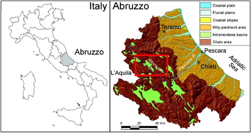
Figure 2. Simplified geolithological scheme of the central eastern Abruzzo area.
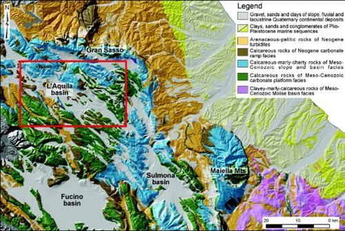
The alignment of basins approximately coincides with a regional paleogeographic and paleotectonic boundary (CitationAPAT, 2006) between a carbonate platform domain to the south (Jurassic-to-Middle Miocene in age) and a coeval, carbonate slope-to-basin domain to the north (). Terrains of the two domains were complexly piled up, through thrusts and fold structures, during the Late Miocene-Early Pliocene compression that affected the region. Synorogenic terrigenous deposits are locally preserved, mostly interposed between the thrust sheets.
Continental deposits outcropping, and buried, in the middle Aterno valley are related to different, and deformed, successions, spanning in age from the Upper Pliocene to the Holocene (e.g., CitationAPAT, 2006; CitationGiaccio et al., 2012; CitationGruppo di Lavoro MS-AQ, 2010 and references therein). However, the basin stratigraphy is different moving from the NW to the SE. In the northwestern area, three main units occur (CitationAPAT, 2006; CitationBagnaia et al., 1992; CitationBlumetti, Di Filippo, Zaffiro, Marsan, & Toro, 2002; CitationGe.Mi.Na., 1963; CitationGruppo di Lavoro MS-AQ, 2010; CitationMancini et al., 2012; CitationTallini et al., 2012). The youngest unit includes Upper Pleistocene to Holocene fluvial, alluvial fan and colluvial deposits, slope debris, and weathering deposits (Middle-Upper Pleistocene in age, outcropping around L'Aquila). These rest on a succession composed of lacustrine deposits, passing upwards to fluvial deposits, and to calcareous breccias and conglomerates, which are related to the Lower Pleistocene–Middle Pleistocene (?). The lowest unit, Upper Pliocene-Early Pleistocene in age, is mostly buried (the upper part outcrops in the Pianola area). It consists of lacustrine deposits, which in the lower part include lignite layers.
In the area spanning from Paganica to San Demetrio (see also CitationBosi & Bertini, 1970; CitationBertini & Bosi, 1993; CitationBoncio et al., 2011; CitationGiaccio et al., 2012), recent – Upper Pleistocene to Holocene – slope deposits, and alluvial deposits outcropping in the floor of the modern Aterno River valley, overly a fluvial and alluvial fan succession (including volcaniclastic layers; outcropping around Paganica), the basal part of which is dated around 0.4 Ma. Such deposits rest on lower Middle Pleistocene fluvial and alluvial fan deposits, outcropping in the San Demetrio – Barisciano area. The oldest unit consists of a Lower Pleistocene lacustrine succession (ranging from 1.8 Ma to >0.78 Ma). It is composed of yellowish silts (outcropping around Poggio Picenze) and of carbonate silts passing laterally into delta deposits, cropping out around Barisciano and Castelnuovo.
3. Dataset and methodology
The work has been carried out by means of geomorphological and morphotectonic surveys, which have been integrated with the analysis of a huge amount of both published and unpublished surface and subsurface geological and geophysical data (see the scheme on the left portion of the map). The pre-existing dataset includes: (i) the official 1:50,000 geological map of the L'Aquila area (Foglio 359 L'Aquila and Foglio 349 Gran Sasso d'Italia of the CARG Project; CitationAPAT, 2006; CitationISPRA, 2010); (ii) 23 geological maps at different scales (1:2000 to 1:5000), 67 geological cross-sections, 336 borehole data and 6 gravimetric maps produced during the Seismic Microzoning studies promoted by the Italian Department of Civil Protection (CitationGruppo di Lavoro MS–AQ, 2010); (iii) geoelectrical data (CitationBosi & Bertini, 1970); (iv) gravimetric data (CitationBlumetti et al., 2002; CitationGe.Mi.Na., 1963) and (v) seismic tomography data (CitationImprota et al., 2012).
The map is implemented within a GIS by means of: DEM and map-based cartographic analysis and morphometry of orography and hydrography (raster and vector data scale 1:25,000, 10 m grid DEM), photogeological analysis (scale 1:10,000), structural geomorphological field mapping (scale 1:10,000), basin fill geometry analysis (geophysical and borehole investigations) and tectonic-geomorphological profiles that couple landforms, deposits and terraces (CitationAscione, Caiazzo, & Cinque, 2007; CitationAscione, Miccadei, Villani, & Berti, 2007; CitationD'Alessandro, Miccadei, & Piacentini, 2008; CitationDella Seta et al., 2008; CitationMiccadei, Piacentini, Dal Pozzo, La Corte, & Sciarra, 2013; CitationMiccadei, Piacentini, Gerbasi, & Daverio, 2012; CitationOtto, Gustavsson, & Geilhausen, 2011).
The tectonic–geomorphological map of the middle Aterno valley (main map) is the result of a detailed geomorphological analysis of topographic maps at 1:5000 scale, aerial photos and orthophotos at 1:5000–1:33,000 scale (provided by Ufficio Infrastrutture Geografiche, Regione Abruzzo), a GIS-aided DEM investigation, and geomorphological field surveys. The lithologies on the map are modified from the official geological map (CitationAPAT, 2006; CitationISPRA, 2010) and are grouped in to three main units, pertaining to the main lithological successions. The study allowed the identification of the main erosional/depositional fluvial, karst, complex-polygenic, structure controlled and tectonic landforms, including active tectonics indicators.
The buried bedrock of the Quaternary infilling of the middle Aterno valley has been reconstructed based on a GIS-aided correlation and interpolation of all georeferenced subsurface data. This allowed the generation of a 40 m grid, which represents the thickness of Quaternary continental deposits and the depth of the top surface of the Mesozoic – Cenozoic pre-orogenic bedrock and Cenozoic sin-orogenic bedrock (left portion of the map).
4. The map
4.1. Overview
The map incorporates four main sections: orography and hydrography section (upper portion), subsurface geological setting section (left portion), main tectonic-geomorphological map section (main map) and the tectonic-geomorphological profiles section (lower portion).The sections are described in the following sub-sections.
4.2. Orography and hydrography
The whole middle Aterno valley is made up of a succession of adjoining, and partly coalescent, morphological depressions at elevation ranging from 500 m to 900 m a.s.l. It is NW-SE elongated for over 40 km with a maximum width of <10 km. The main topographic lows are (see upper part of the map): the Barete–Pizzoli plain (700 m a.s.l.); the Scoppito basin (700–750 m a.s.l.); the Preturo plain (660 m a.s.l.); the western L'Aquila–Coppito plain (640 m a.s.l.); the Monticchio plain (590 m a.s.l.); the Paganica–San Demetrio plain (550–620 m a.s.l.); the Barisciano plain (850 m a.s.l.); the Castelnuovo–Civitaretenga plain (740 m a.s.l.); the Navelli plain (670 m a.s.l.).
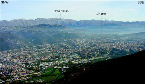
The L'Aquila and Barisciano highs define three major sub basins, from northwest to southeast: the western L'Aquila – Coppito basin; the Paganica–San Demetrio basin; the Castelnuovo–Civitaretenga basin. These basins are surrounded, towards SW and NE, by NW-SE elongated ridges of carbonate rocks, with elevations ranging from 1000 m to >2000 m, up to the 2912 m a.s.l. high Gran Sasso massif (toward the NE; and ) and to the 2204 m a.s.l. high Mt. Ocre (towards the SW). Minor ridges are located within the major basins, and separate adjacent plains outlining a very articulate physiography.
Figure 3. Panoramic view of the middle Aterno River valley from west.
The whole middle Aterno valley is presently crossed from the NW to the SE by the Aterno River, and it is included in the Aterno drainage basin. Only the Castelnuovo–Civitaretenga plain pertains to an endoreic drainage basin. The drainage pattern is mostly angular with some patches of parallel, trellis and contorted patterns. Local multibasinal and contorted patterns characterise the karst areas in the NE part of the study area. The azimuth distribution of the drainage network for the main drainage sub-basins shows that the general angular pattern is developed mostly on NW-SE and SW-NE orientations, and secondarily on NNW-SSE and WSW-ENE orientations.
The long profiles and steepness index investigation (CitationWobus et al., 2006) outline several knick points along the main rivers in the study area. Some either sharp or smooth knick points are also present along the Aterno River, in the middle and lower parts, which are also depicted on the main map. These features are related to lithostructural control or to tectonic features.
The overall configuration of the drainage, suggests a complex evolution of the hydrography marked by strong modifications over time.
4.3. Tectonic geomorphology
The three major sub-basins which occur in the study area (i.e., western L'Aquila–Coppito, Paganica–San Demetrio and Castelnuovo–Civitaretenga basins) are bounded by main NW-SE trending extensional faults/fault systems at their NE and SW boundaries and recent studies note that such faults/fault systems are still active (e.g., CitationBlumetti et al., 2013; CitationBoncio et al., 2010; CitationDi Bucci, Vannoli, Burrato, Fracassi, & Valensise, 2011; CitationGalli et al., 2010; CitationPizzi & Galadini, 2009; CitationTallini et al., 2012). However, on the basis of coupled surface and subsurface evidence, it appears that the present-day morphotectonic setting results from a complex and long-lived evolution, also including a migration of the main depocentres (e.g., the Paganica–San Demetrio basin area; CitationGiaccio et al., 2012 and references therein).
4.3.1. Subsurface geological setting
Overall information from borehole stratigraphy and from geophisycs has been used to reconstruct the subsurface geological model of the middle Aterno valley (CitationAPAT, 2006; CitationBlumetti et al., 2002; CitationBosi & Bertini, 1970; CitationGe.Mi.Na., 1963; CitationGruppo di Lavoro MS–AQ, 2010; CitationImprota et al., 2012). The thickness of the continental infilling is constrained by 13 drillings reaching the basin bedrock, which consists of Mesozoic–Cenozoic carbonate rocks, and Miocene– Lower Pliocene sandy–silty silicoclastic deposits. Deep drillings point to the occurrence of around 190-m thick deposits in the areas around L'Aquila and between Bazzano and Onna, respectively. However, the occurrence at some places of much larger cumulative sedimentary thickness is inferred from geophysical information.
The reconstructed subsurface geological model points to the occurrence of five main depocentres, located in the NW, central and SE parts of the middle Aterno valley. These are respectively located: (i) to the SW of L'Aquila (inferred maximum bedrock depth around 350–400 m; orientation N150), (ii) to the west of the Bazzano and Monticchio carbonate ridges (maximum depth around 350–400 m; orientation N90), (iii) in the middle part of the Paganica–San Demetrio basin (depth around 250–300 m; orientation N150), (iv) in the SE part of such basin (San Demetrio area; estimated maximum bedrock depth >550 m; orientation N050), and (v) to the SW of Barisciano, in the Castelnuovo–Civitaretenga basin (again estimated maximum bedrock depth >550 m; orientation N120).
The buried bedrock morphology only partly mirrors the spatial distribution of the present-day topographic highs and lows. In fact, while the depocentre in the middle Paganica–San Demetrio basin develops in the subsurface of the present-day alluvial basin, very thick (≥400/500 m) sedimentary bodies identified in the NW and SE parts of the middle Aterno valley overlap topographic highs interposed between the modern alluvial/lacustrine plains (see main map). Outcropping units, in such highs, are relatively old Lower to Middle Pleistocene – alluvial/lacustrine successions. Overall evidence testifies to important changes in the perimeter of the depocentres in the middle Aterno valley over the Early Pleistocene to present time span.
4.3.2. Morphotectonic features (Main Map)
Mapped landforms are focused around the main morphotectonic features of the landscape. They have been grouped in to the following categories: structural, fluvial, lacustrine, karst, and complex landforms. The lithologies on the map (modified from CitationAPAT, 2006; CitationISPRA, 2010) are grouped in to three main units, pertaining to the main lithological successions:
– Quaternary continental deposits (Postorogenic succession);
– Arenaceous-pelitic bedrock (Synorogenic succession);
– Calcareous bedrock (Preorogenic succession).
Structural landforms.
Structural landforms are represented by structural and fault-related slopes and ridges (dip slopes, fault scarps, fault escarpments, triangular facets, saddles; ) and fault-controlled fluvial features (subsequent and back-tilted valleys). Fault-controlled landforms show a dominant NW-SE trend, and a subordinate E-W trend (e.g., the northern fault escarpment of Mt. Cerro, which rises from the Paganica–San Demetrio basin floor). Widespread, several tens to a few hundred metres high fault escarpments, and minor fault scarps, provide evidence that activity of the dense network of sub-parallel, NW-SE trending and both SW and NE dipping, extensional faults (spanning from the middle Aterno valley to the SW the Gran Sasso ridge footslope) has strongly controlled landscape development in the study area (as suggested by CitationBertini & Bosi, 1993; CitationGiaccio et al., 2012, for the Paganica–San Demetrio and neighbouring area).
Figure 4. Morphotectonic features: (a) fault escarpment and tectono-karst basin in the Santo Stefano di Sessanio area (in the background fault escarpment at the front of Mt. Ocre); (b) detail of a fault scarplet at the base of a fault escarpment in the Santo Stefano di Sessanio area; (c) dip slope on Upper Pliocene–Lower Pleistocene breccias in the Barisciano area; (d) fault escarpment on the northern slope of Mt. Cerro (lateral view from the village of Fossa); (e) Mt. Bazzano fault scarp; (f) evidences of reactivation after the 6 April 2009 Mw. 6.3 L'Aquila earthquake on the Mt. Bazzano fault scarp.
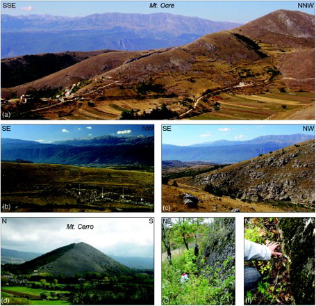
Mainly NW-SE trending fault escarpments outline the boundaries of the western L'Aquila–Coppito, Paganica–San Demetrio and Castelnuovo–Civitaretenga basins. The fault escarpments display variable dissection degree (e.g., the faceted Mt. Pettino front), and steepness. The steeper escarpments are formed in carbonate rocks, whereas the smoother ones are formed in more erodible rocks (e.g., Lower Pleistocene lacustrine deposits of the Postorogenic succession) outcropping in the NE mountain front (e.g., Poggio Picenze area) of the Paganica–San Demetrio basin. All these basins are characterised by an overall morphostructural asymmetry. The western L'Aquila–Coppito and Castelnuovo–Civitaretenga basins are bounded towards the NE by straighter (in plan view) and higher fault escarpments than on the SW side. They may be considered the long-term surface expression of the main faults at their NE boundaries, which are also known as active extensional faults, respectively the Mt. Pettino fault and the San Pio fault (CitationDi Bucci et al., 2011). Morphostructural asymmetry also characterises the Paganica–San Demetrio basin. It is bounded to the SW by straight (both in profile and in plan view) fault escarpments developed on faults which control the subsurface basin architecture (left portion of the map; see also CitationImprota et al., 2012). On the other hand, the NE mountain front displays a more mature, composite profile, with several slope breaks related to the occurrence of uplifted terraces and alluvial fans and paleosurfaces (e.g., the Paganica and San Demetrio areas, and NE areas; (a–c); see Complex landforms section). Such features suggest that the fault system at the NE basin boundary (which is still active) recorded long-lived, unsteady activity. Geomorphic evidence points to recent activity of faults at the SW basin boundary. This is inferred from the composite profile of the Bazzano fault escarpment, showing a marked steepening in its basal part, and by the occurrence of rectilinear scarps following the toe of the Fossa fault scarp (see below). It is worth noting that fault systems bounding on both sides the Paganica–San Demetrio basin (i.e., the so-called Paganica, Monticchio–Fossa and Bazzano faults) ruptured during the 6 April 2009 L'Aquila earthquake ((e and f); e.g., CitationBoncio et al., 2010; CitationFalcucci et al., 2009; CitationVittori et al., 2011 and references therein).
The almost flat Paganica–San Demetrio basin floor is characterised by the occurrence of some several km long, ∼1 m high, rectilinear, NW-SE trending scarps detected by detailed topography analysis. In some cases, these scarps correspond to features of the fluvial pattern (straight NW-trending trunks, knickpoints), which is particularly sensitive to tectonic perturbations (CitationAscione, Caiazzo, & Cinque, 2007a; CitationAscione, Mazzoli, Petrosino, & Valente et al. and references therein).
Further structural landforms have been identified in the area N of L'Aquila. These consist of overfilled valley floors bounded downstream by narrow gorges. Such features have been interpreted as the result of back tilting along a NW-oriented, SW-dipping extensional fault, and mapped as back-tilted valleys.
Fluvial landforms.
Active and relic fluvial landforms and alluvial fans are widespread over the entire study area. The poorly dissected active Aterno River alluvial plain has been subdivided into two sectors, i.e. the western L'Aquila-Coppito plain to the NW, and the Paganica–San Demetrio plain to the SE. They are separated by a NW-SE-oriented gorge cut in Quaternary deposits (calcareous breccias) south of the town of L'Aquila. The western L'Aquila–Coppito and the Paganica–San Demetrio alluvial plains are bounded by fluvial terraces on their left sides. Three orders of terraces have been distinguished. The complete flight of fluvial terraces is well exposed in the San Demetrio area.
Mapped alluvial fans mostly occur along the northeastern mountain front of the Aterno valley, in which three generations of fans have been distinguished. They include both active (most of the third-order fans, e.g., the large depositional body of the Paganica alluvial fan) and dissected landforms. Incised, and in some instances eroded, alluvial fans, correspond to the first- and second-order fans. These are well exposed in the Poggio Picenze and San Demetrio areas.
Mapped fluvial landforms also include both recent (gorges and river bends) and relic (hanging valleys, windgaps, beheaded valleys) erosional features.
Lacustrine landforms.
A paleo lacustrine depositional surface occurs in the Castelnuovo–Civitaretenga basin. It is a NW-SE-oriented plain, which lies at an elevation of ∼800 m a.s.l., hanging about 200 m higher than the modern Aterno valley floor. It is located upstream of the NW-SE-oriented Civitarenga gorge and saddle.
Karst landforms.
Karst landforms include both recent and dissected tectono-karst plains, dolines, doline fields and sinkholes.
Most tectono-karst plains are active. They primarily occur in the NE part of the study area and, in most cases, are characterised by an elongated shape and a NW-SE orientation. Among the few dissected tectono-karst plains, the larger one is the Roio plain (SW part of the study area).
Dolines are widespread in the NE part of the study area and in the low relief landscape which separates the Castelnuovo paleolacustrine plain from the Aterno valley. Two wide doline fields have also been identified in the SW part of the study area, which feed the Stiffe caves karst springs, together with the wide tectono–karst plains in the SW side of the area (Rocca di Cambio).
Several sinkholes are identified in the Paganica–San Demetrio basin and surrounding areas (CitationNisio, 2008; CitationSanto, Ascione, Del Prete, Di Crescenzo, & Santangelo, 2011). Four different types of ‘karst collapse sinkholes’ (CitationSanto et al., 2011) have been distinguished: (i) recent or historical sinkholes (areas S of the Roio plain and around Fossa); (ii) alluvial sinkholes (areas around Monticchio and San Demetrio, and the Castelnuovo plain); (iii) cover sinkholes, affecting Quaternary deposits (southern Paganica–San Demetrio basin); (iv) bedrock sinkholes (mountain fronts bounding both the Castelnuovo and the Paganica–San Demetrio basins). Such features, based on regional scale studies on the Central and Southern Apennines (CitationSanto et al., 2011), are interpreted as the surface evidence of deep-seated dissolution phenomena associated with active faults.
Complex landforms.
Complex landforms consist of low-relief erosional surfaces (i.e., paleosurfaces) carved in the carbonate bedrock or – more rarely – in the Quaternary deposits. The larger paleosurfaces occur in the range of 700 m to 1300 m a.s.l., and have been classified based on their elevation distribution (100 m intervals). Smaller features, lying at elevations >1400 m a.s.l., are undifferentiated. Such features may be interpreted either as eroded and dissected, or offset, remnants of larger landforms, formed in response to fluvial – and associated karst – planation phenomena.
The highest paleosurface remnants occur on top of the fault-bounded ridges surrounding the middle Aterno valley. They develop at elevations ranging from ∼1300 m to 1900 m a.s.l., and are characterised by an overall stair-like distribution, with decreasing elevation from both the SW and NE towards the western L'Aquila–Coppito, Paganica–San Demetrio and Castelnuovo–Civitaretenga alluvial/lacustrine plains. According to regional scale studies (e.g., CitationGaladini, Messina, Giaccio, & Sposato, 2003), the paleosurfaces on top of the carbonate ridges result from the fragmentation of low-relief landscapes, which were formed at low elevation during the Pliocene, and subsequently uplifted and displaced due to the activity of normal faults. However, local studies carried out in the area surrounding the Paganica–San Demetrio basin (CitationGiaccio et al., 2012) point out that formation of the erosional/depositional surface remnants, located up to about 1100 m a.s.l. (which in some instances postdate activity of extensional faults), is coeval with the Quaternary tectonic/depositional evolution of the Aterno valley.
Progressively younger paleosurfaces, formed at different intervals breaching the base level lowering, may be distinguished from features derived from offset of a formerly continuous low-relief landscape based on both their spatial distribution, and on the shape of the scarp which separates two adjacent remnants. Within the flights of surfaces of the former type, younger and lower surfaces are inset in and/or spatially surround higher paleosurfaces, with the interposed scarps having variable shapes in plan form (e.g., surfaces from 900 to 1300 m in the area to the W and SW of Mt. Rofano and Mt. Ruzza). Conversely, offset surface remnants are vertically separated, and spatially limited, by straight (although variably dissected) fault scarps, with the lowered surfaces not cutting across the fault traces (e.g., area to the E-NE of Mt. Carpelone and Mt. Camarda on the map). The spatial distribution of the mapped paleosurface remnants provides information on the early development of the drainage network in the study area. This is inferred from the remnants hanging from 900 m up to about 1200 m a.s.l. along the flanks of the Raiale river gorge (NE of Paganica). Such surfaces may be interpreted as strath terraces developed during stages of the stepped incision of the valley, which postdates formation of the remnants lying at about 1500 m a.s.l. on top of the ridges on both sides of the gorge.
4.3.3. Tectonic-geomorphological profiles
Geomorphological and available stratigraphical information on key areas has been synthesised in three profiles (lower portion of the map), chosen based upon available deep boreholes and geophysical data. The profiles have been based on comparison and correlation of subsurface information on lithology and thickness of buried bodies (inferred from drillings and geophysics) with surface morphotectonic field data. Integration of surface and subsurface data with morphostructural information reported above each profile provides a key to the morphostratigraphical and morphotectonic framework of the study area.
The profiles clearly show the increasing thickness of continental deposits moving towards the SE sector of the basin. In particular, sections B and C don't reach bedrock at 200–300 m of depth.
In profile A (Pettino area) the bedrock is covered by only 20–70 m of Upper Pleistocene–Holocene alluvial deposits. In the NE part alluvial deposits are separated by fault escarpments and triangular facets and dissected by subsequent valleys.
Profile B, located near L'Aquila town, shows a thick continental sedimentary body characterised, in the first ∼50–100 m of depth, by slope breccias (Lower Pleistocene). These breccias lie on lacustrine clay and silt deposits about 250-m thick which can be ascribed to Upper Pliocene–Lower Pleistocene time. The deepest portion (last 150 m) of this lacustrine succession (Upper Pliocene) is known only by deep borehole data and is characterised by the presence of lignite deposits (CitationGe.Mi.Na., 1963; CitationGruppo di Lavoro MS-AQ, 2010). The Quaternary continental succession is uplifted and dissected by a wide gorge; paleosurfaces are preserved on both sides of the valley, on continental deposits or bedrock. The valley is bounded by wide fault escarpments.
Profile C outlines the very thick (up to >500 m) Upper Pliocene-Middle Pleistocene continental succession passing from a lacustrine environment to a deltaic and fluvial environment with a clear regressive trend. This succession is bounded toward SW by NW-SE trending and NE dipping faults characterised by a wide fault escarpment; toward NE it is displaced and uplifted by extensional tectonics along NW-SE trending and SW dipping faults outlined by fault scarps and escarpment and by a stair-like sequence of paleosurfaces on Quaternary continental deposits. The NE side of the middle Aterno valley, is characterised by remnants of high elevation paleosurfaces on bedrock, dissected by several NW-SE elongated tectono-karst basins, bounded by NE dipping and SW dipping fault escarpments.
5. Conclusion
This work led to the production of the Tectonic-geomorphological map of the middle Aterno River valley (Abruzzo, Central Italy). This map incorporates orography and drainage network data, surface morphotectonic data, and subsurface sedimentary basin models. The map contributes the recognition of morphotectonic features at basin scale, the detection of tectonic control on landscape, and the reconstruction of paleo-landscapes, by means of tectonic-geomorphological profiles. It also contributes to the definition of the main phases of post-orogenic landscape evolution in the tectonic intermontane basins along the middle Aterno River valley (Apennines chain) from the Early Pleistocene to Present. This results from the link between alternating morphotectonics and surface processes, due to regional rock uplift processes, local tectonics and alternating slope, fluvial and karst processes.
Overall information shows that the modern topographic lows represent a delayed response to the extensional tectonics, which have been active in the study area at least since the Early Pleistocene. A sequence of fault escarpments bounds the basins on both sides (NE and SW) outlining step-like (SW) and ridge and basins (NE) landscapes, displacing and truncating previous paleosurfaces resting on both bedrock and Quaternary continental deposits.
The formation of the western L'Aquila–Coppito, Paganica–San Demetrio and Castelnuovo–Civitaretenga basins as tectonic basins along NW-SE trending, SW-dipping Mt. Pettino, Paganica-San Demetrio and Castelnuovo fault systems, and NW-SE trending NE-dipping Bazzano-Fossa fault system, caused a significant change in the middle Aterno valley perimeter, in the spatial distribution of the main topographic highs and lows, and in the drainage basins and network geometry. Former (Early Pleistocene to early Middle Pleistocene) depocentres, outlined by the Quaternary continental deposits thickness analysis, have been affected by the mentioned fault systems, also giving rise to either dissected (i.e., the gorge cut in the L'Aquila high), or undissected, thresholds (i.e., saddles, wind gaps) which separate the present-day drainage basins from endoreic areas. Evidence of such phenomena is represented by the uplifted terraces (formed in the Lower to Middle Pleistocene lacustrine/alluvial successions), and erosional surfaces in the area spanning from Paganica to San Demetrio, in the Barisciano high, and in the L'Aquila area.
Software
The map presented in this work has been produced in two phases, carried out using different software applications. In the first phase, vector and raster data and the main map were managed using Esri ArcGIS10.1. In the second phase, the final editing was managed with Corel Draw®.
Main Map: Tectonic Geomorphological Map of the Middle Aterno River Valley (Abruzzo, Central Italy)
Download PDF (10.1 MB)Acknowledgements
The authors wish to thank the Struttura Speciale di Supporto Sistema Informativo Regionale of Abruzzo Region (http://www.regione.abruzzo.it/xcartografia/) for providing the topographic data and aerial photos used for the geomorphological investigations and for the morphotectonic map.
The authors are also grateful to Chris Orton, Doriano Castaldini, and Jean-Pierre Peulvast, the three reviewers, which greately improved the map and the text with their very useful comments and suggestions.
The work was supported by Project DPC – RELUIS 2010–2013, Linea RS 2.1 – Definition of geological models and site amplification for impulsive earthquakes near-source (A. Santo) and by University ‘G. d'Annunzio’ of Chieti Pescara funds (E. Miccadei).
References
- APAT. (2006). Carta geologica d'Italia alla scala 1:50,000, Foglio 359 “L'Aquila”. APAT-Servizio Geologico d'Italia and Regione Abruzzo.
- Ascione, A., Caiazzo, C., & Cinque, A. (2007). Recent faulting in Southern Apennines (Italy): geomorphic evidence and implications for rates of activity. Italian Journal of Geosciences, 126(2), 293–305.
- Ascione, A., Mazzoli, S., Petrosino, P., & Valente, E. (2013). A decoupled kinematic model for active normal faults: Insights from the 1980, MS = 6.9 Irpinia earthquake, southern Italy. Geological Society of America Bullettin, 125(7–8), 1239–1259. . doi: 10.1130/B30814.1
- Ascione, A., Miccadei, E., Villani, F., & Berti, C. (2007). Morphostructural setting of the Sangro and Volturno rivers divide area (Central-Southern Apennines, Italy). Geografia Fisica e Dinamica Quaternaria, 30, 13–29.
- Bagnaia, R., D'Epifanio, A., & Sylos Labini, S. (1992). Aquila and Subequan basins: an example of Quaternary evolution in central Apennines. Italy. Quaternaria Nova, 2, 187–209.
- Bertini, T., & Bosi, C. (1993). La tettonica quaternaria della conca di Fossa (L'Aquila). Il Quaternario, 6, 293–314.
- Blumetti, A. M., Di Filippo, M., Zaffiro, P., Marsan, P., & Toro, B. (2002). Seismic hazard characterization of the city of L'Aquila (Abruzzo, Central Italy): new data from geological, morphotectonic and gravity prospecting analyses. Studi Geologici Camerti, 2002, 7–18.
- Blumetti, A. M., Guerrieri, L., & Vittori, E. (2013). The primary role of the Paganica-San Demetrio fault system in the seismic landscape of the Middle Aterno Valley basin (central Apennines). Quaternary International, 288(4), 183–194. . doi: 10.1016/j.quaint.2012.04.040
- Boncio, P., Pizzi, A., Brozzetti, F., Pomposo, G., Lavecchia, G., Di Naccio, D., & Ferrarini, F. (2010). Coseismic ground deformation of the April 6th 2009 L'Aquila earthquake (central Italy, Mw6.3). Geophysical Research Letters, 37(6), L06308 (see http://onlinelibrary.wiley.com/doi/10.1029/2010GL042807/abstract). . doi: 10.1029/2010GL042807
- Boncio, P., Pizzi, A., Cavuoto, G., Mancini, M., Piacentini, T., Miccadei, E., … Working Group Macroarea 3. (2011). Geological and geophysical characterization of the Paganica – San Gregorio area after the April 6, 2009 L'Aquila earthquake (Mw 6.3, central Italy): implications for site response. Bollettino di Geofisica Teorica e Applicata, 52(3), 491–512. doi 10.4430/bgta0014.
- Bosi, C., & Bertini, T. (1970). Geologia della media valle dell'Aterno. Memorie della Società Geologica Italiana, 9, 719–777.
- Chiarabba, C., Amato, A., Anselmi, M., Baccheschi, P., Bianchi, I., Cattaneo, M., … Valoroso, L. (2009). The 2009 L'Aquila (central Italy) MW6.3 earthquake: Main shock and aftershocks. Geophysical Research Letters, 36, L18308 (see http://onlinelibrary.wiley.com/doi/10.1029/2009GL039627/abstract). . doi: 10.1029/2009GL039627
- Ciccacci, S., D'Alessandro, L., Dramis, F., & Miccadei, E. (1999). Geomorphologic Evolution and Neotectonics of the Sulmona Intramontane Basin (Abruzzi, Apennine, Central Italy). Zeirschrift für Geomorphologie. Suppl.-Bd, 118, 27–40.
- D'Alessandro, L. Miccadei, E., & Piacentini, T. (2008). Morphotectonic study of the lower Sangro River valley (Abruzzi, Central Italy). Geomorphology, 102, 145–158. . doi: 10.1016/j.geomorph.2007.06.019
- Della Seta, M., Del Monte, M., Fredi, P., Miccadei, E., Nesci, O., Pambianchi, G., … Troiani, F. (2008). Morphotectonic evolution of the Adriatic piedimont of the Apennines: An advancement in the knowledge of the Marche – Abruzzo border area. Geomorphology, 102(1), 119–129. . doi: 10.1016/j.geomorph.2007.06.018
- Demangeot, J. (1965). Neotectonique du Gran Sasso (Apennin Central). Revue de géographie physique et de géologie dynamique, 7, 223–234.
- Di Bucci, D., Vannoli, P., Burrato, P., Fracassi, U., & Valensise, G. (2011). Insights from the Mw 6.3, 2009 L'Aquila earthquake (Central Apennines) - unveiling new seismogenic sources through their surface signatures: The adjacent San Pio Fault. Terra Nova, 23, 108–115. doi:10.1111/j.1365–3121.2011.00990.x. doi: 10.1111/j.1365-3121.2011.01026.x
- Falcucci, E., Gori, S., Peronace, E., Fuselli, G., Moro, M., Saroli, M., … Galadini, F. (2009). The Paganica fault and surface coseismic ruptures due to the April 6, 2009 earthquake (L'Aquila, Central Italy). Seismological Research Letters, 80, 940–950. . doi: 10.1785/gssrl.80.6.940
- Galadini, F., Messina, P., Giaccio, B., & Sposato, A. (2003). Early uplift history of the Abruzzi Apennines (central Italy): Available geomorphological constraints. Quaternary International, 101–102, 125–135. . doi: 10.1016/S1040-6182(02)00095-2
- Galli, P., Giaccio, B., & Messina, P. (2010). The 2009 central Italy earthquake seen through 0.5 Myr-long tectonic history of the L'Aquila faults system. Quaternary Science Reviews, 29, 3768–3789. . doi: 10.1016/j.quascirev.2010.08.018
- Ge.Mi.Na. (1963). Ligniti e torbe dell'Italia continentale. ILTE Ed. Torino IP. 319 pp.
- Giaccio, B., Galli, P., Messina, P., Peronace, E., Scardia, G., Sottili, G., … Silvestri, S. (2012). Fault and basin depocentre migration over the last 2 Ma in the L'Aquila 2009 earthquake region, central Italian Apennines. Quaternary Science Reviews, 56, 69–88. . doi: 10.1016/j.quascirev.2012.08.016
- Gruppo di Lavoro MS-AQ. (2010). Microzonazione sismica per la ricostruzione dell'area aquilana. Regione Abruzzo-Dipartimento della Protezione Civile, L'Aquila, 3 vol. and DVD-rom.
- Improta, L., Villani, F., Bruno, P. P., Castiello, A., De Rosa, D., Varriale, F., … Giacomuzzi, G. (2012). High-resolution controlled-source seismic tomography across the Middle Aterno basin in the epicentral area of the 2009, Mw 6.3, L'Aquila earthquake (central Apennines, Italy). Italian Journal of Geosciences, 131(3), 373–388. doi: 10.3301/IJG.2011.35.
- ISPRA. (2010). Carta geologica d'Italia alla scala 1:50,000, Foglio 349 “Gran Sasso d'Italia”. ISPRA-Servizio Geologico d'Italia and Regione Abruzzo. Rome.
- Mancini, M., Cavuoto, G., Pandolfi, L., Petronio, C., Salari, L., & Sardella, R. (2012). Coupling basin infill history and mammal biochronology in a Pleistocene intramontane basin: The case of western L'Aquila Basin (central Apennines, Italy). Quaternary International, 267, 62–77. . doi: 10.1016/j.quaint.2011.03.020
- Marini, G. (1967). Il Lago pleistocenico della Conca de L'Aquila. 81 pp. Lanciano.
- Miccadei, E., Paron, P., & Piacentini, T. (2004). The SW escarpment of the Montagna del Morrone (Abruzzi, Central Italy): geomorphology of a fault-generated mountain front. Geografia Fisica e Dinamica Quaternaria, 27, 55–87.
- Miccadei, E., Piacentini, T., Dal Pozzo, A., La Corte, M., Sciarra, M. (2013). Morphotectonic map of the Aventino-Lower Sangro valley (Abruzzo, Italy), scale 1:50,000. Journal of Maps, 9(3), 390–409. . doi: 10.1080/17445647.2013.799050
- Miccadei, E., Piacentini, T., Gerbasi, F., Daverio, F. (2012). Morphotectonic map of the Osento River basin (Abruzzo, Italy), scale 1:30,000. Journal of Maps, 8(1), 62–73. . doi: 10.1080/17445647.2012.668764
- Nisio, S. (Ed.). (2008). I fenomeni naturali di sinkhole nelle aree di pianura italiane. Memorie Descrittive della Carta Geologica d'Italia Volume, 85, 480 pp.
- Otto, J. C., Gustavsson, M., & Geilhausen, M. (2011). Cartography: design, symbolisation and visualisation of geomorphological maps. In M. J. Smith, P. Paron, & J. Griffiths (Eds.), Geomorphological mapping: A handbook of techniques and applications (pp. 253–295). London: Elsevier.
- Pizzi, A., & Galadini, F. (2009). Pre-existing cross-structures and active fault segmentation in the northern-central Apennines (Italy). Tectonophysics, 476, 304–319. . doi: 10.1016/j.tecto.2009.03.018
- Santo, A., Ascione, A., Del Prete, S., Di Crescenzo, G., & Santangelo, N. (2011). Collapse sinkhole distribution in the carbonate massifs of central and southern Apennines. Acta Carsologica, 40(1), 95–112.
- Tallini, M., Cavuoto, G., Monaco, F. D., Fiore, V. D., Mancini, M., Caielli, G., … Rapolla, A. (2012). Seismic surveys integrated with geological data for in-depth investigation of Mt. Pettino active fault area (western L'Aquila basin). Italian Journal of Geosciences, 131(3), 389–402. doi: 10.3301/IJG.2012.10.
- Vittori, E., di Manna, P., Blumetti, A. M., Commerci, V., Guerrieri, L., Esposito, E., … Cowie, P. A. (2011). Surface faulting of the April 6, 2009, Mw 6.3 L'Aquila earthquake in Central Italy. Bulletin of the Seismological Society of America, 101, 1507–1530. doi:10.1029/2009GL039337. doi: 10.1785/0120100140
- Wobus, C., Whipple, K., Kirby, E., Snyder, N., Johnson, J., Spyropolou, K., … Sheehan, D. (2006). Tectonics from topography: Procedures, promise and pitfalls. In S. D. Willett et al. (Eds.), Tectonics, climate and landscape evolution. Geological Society of America, Special Papers, 398, 55–74. doi: 10.1130/2006.2398(04).