
Abstract
This contribution presents a 1:200,000 scale geologic map of the Anecón Grande area in northern Patagonia (41°00′–41°30′ S/70°00′–70°30′ W, Río Negro province, Argentina), covering around 2300 km2. The map results from a combination of classical visual stereoscopic interpretation of aerial photographs and remote sensing data, later corroborated by field surveys. The geology of the Anecón Grande is composed of a thick succession of intermediate to acidic volcanic and pyroclastic rocks (Late Triassic to Paleogene), and a thick pile of basaltic lava flows of the Somuncura Plateau (Neogene to Quaternary). Volcanic landforms, flat lava flows called ‘escoriales’, and regional peneplains are typical Patagonian landscapes in the Anecón Grande area. The map is of further interest for its socio-cultural relevance because the Anecón Grande area was settled by the Anikhon Grande Mapuche community, being one of the Native South American People and First Nations in Patagonia. Seven sites of geological interest are shown on the map which informs the reader of source areas of lithic materials (geodes, obsidian, peridotite mantle xenoliths) which may be potentially useful in the manufacturing of handicrafts by Mapuche people.
1. Introduction
The Anecón Grande area is located in northern Patagonia in the foothills of the Andes Mountains in the province of Río Negro, Argentina. The area is named after the hill called Anecón Grande (1976 m. a. s. l.) which covers an area of 2256 km2 between the hamlets of Clemente Onelli in the East, and Comallo in the West (from 41°00′ to 41°30′ S latitude and 70°00′ to 70°30′ W longitude; (a and b)). It lies on the western edge of the so-called ‘Linea Sur’ (South Line) which is an important site of the Río Negro province because it is the only populated area in the southern part of the province. The ‘Linea Sur’ is composed of a group of villages which lie along Interstate 23 (Main and Old Patagonian Road) from the Atlantic coast in the East, across the sparsely populated Patagonian peneplain, to Bariloche in the West near the Andes ((b)). Over this vast territory, the Anecón Grande area is of great interest and includes a unique landscape characterized by magnificent volcanic landforms (e.g. Somuncura Plateau, Anecón Grande hill, ) and regional peneplains (CitationGonzález Días & Malagnino, 1984). The area is also of interest for its extreme weather conditions (dry and windy), steppe vegetation, archaeology, and paleontology.
Figure 1. (a) Location of the Anecón Grande study area within the geographic context of Río Negro Province of Argentina and (b) Sketch map of Río Negro Province depicting locations cited in the text.
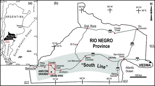
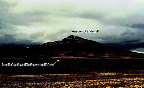
Figure 2. Anecón Grande hill is an eroded strato-volcano, mainly composed of intermediate Tertiary volcanic and pyroclastic rocks. The Somuncura Plateau is represented here by one of its youngest basaltic lava flows, which passes through the paleo-valley of Comallo Creek.
The area is also home to the Anecón Grande Mapuche Reservation (41°20′04.0″ S/70°12′34″ W). The Mapuche are Native South American and First Nations people, who have lived in Patagonia since at least the Upper Pleistocene (13-10 ka) (CitationAschero, 2000). The word Mapuche, meaning ‘people of the land’ (Mapu meaning ‘land’ and Che meaning ‘people’, CitationEspósito, 2003), refers to any ethnic group within the Mapuche Nation that speaks a dialect called ‘Mapudungun’ (‘language of the land’), which is still currently spoken in the community. The Mapuche are bilingual because they speak Mapudungun and Spanish, the official language of Argentina. Today, the Lof Anecón Grande (or Anikhon in Mapudungun, Lof meaning ‘clan’) community includes 33 families that belong to the same family tree (clan), under the leadership of the same Longko (‘head’), who has social, religious, and administrative responsibilities (CitationBengoa, 2000). The Mapuche people live throughout the Anecón Grande area, with farming or breeding of sheep and cattle their main occupations. They also are engaged in making bricks and manufacturing lithic handicrafts (carving rocks and industrial minerals).
Scarce previously published work about the Anecón Grande area make only vague mention of the geology, including a general stratigraphic framework of the Rio Negro province established by CitationWichman (1934) and CitationFeruglio (1941), which was later expanded by (CitationRabassa 1978) and CitationCoira, Franchi, & Nullo (1985), and later compiled by (CitationGonzález 1994). A more detailed description of the volcanic and pyroclastic stratigraphy of the Anecon Grande and its surroundings was completed by CitationGonzalez (1998). The Anecón Grande area is included in the Argentine Geological and Mining Survey's 1:250,000 scale 4169-III sheet, ‘Ingeniero Jacobacci’ (CitationGonzález, Coluccia, & Franchi, 1999, unpublished).
In this publication, we present the geological map of the Anecón Grande area (1:200,000 scale, 41°00′–41°30′ S latitude and 70°00′–70°30′ W longitude), with special emphasis on the igneous stratigraphy. We also summarize seven sites of geological interest as source areas of lithic materials (e.g. geodes, obsidian, peridotite mantle xenoliths, among others), which may be useful in the manufacturing of handicrafts by the people of the Anecón Grande Mapuche Reservation.
This is the first comprehensive geological map of the Anecón Grande, which is based on landform recognition via remote sensing analysis, supplemented by field surveys and ground control points. The map presented herein is the final result of geologic, stratigraphic and structural field surveys performed by the authors between 1994 and 1996.
2. Methods
2.1 Original map preparation
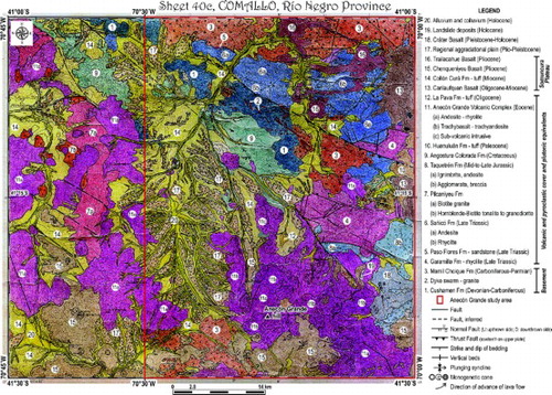
In the early 1990s, the geological map of the Anecón Grande area was prepared using traditional visualization methods, when geographical information systems (GIS) and digital techniques for mapping were relatively new. The different geological units, especially those included in volcanic and pyroclastic landforms, were identified by visual stereoscopic interpretation of aerial photograph stereo-pairs (1:40,000–1:65,000 scales), aided by visual analysis of printouts from Landsat 5 Thematic Mapper satellite images. Both the aerial photos and the satellite images were provided by the Argentine Geological Survey (SEGEMAR). Afterwards, the interpreted photographs were compiled into a cartographic mosaic and reduced to 1:200,000 scale. Topographic map, sheet 40c of ‘Comallo’, Río Negro Province, published by the Instituto Geográfico Nacional (Carta Topográfica de la República Argentina maps in 1:200,000 scale; www.ign.gob.ar/) was used as the topographic base, and for elevation points and toponyms. The map was corroborated with field surveys, but its final version was never published. A scanned image of the whole Comallo sheet (handmade map) is presented in . The Anecón Grande area is labeled within this map.
Figure 3. Scanned image of the original handmade geologic map of the Anecón Grande area. Since references were not included on the original map, a legend has been added. The map is shown unaltered from the original paper version.
2.2 Map digitization
A digitized geological map of the Anecón Grande area was created using Esri ArcGIS 9.3. The Landsat 7 Enhanced Thematic Mapper+ (30 m spatial resolution) satellite image was used as a new cartographic base, in addition to the scanned Comallo sheet for ground control points (), having been georeferenced to the Universal Transverse Mercator (UTM) coordinate system (WGS 84 Datum, 19S zone). Satellite images were overlaid by a shaded – relief images of South America from the ETOPO-1 Global Relief Model (CitationAmante & Eakins, 2009), the Shuttle Radar Topography Mission (SRTM) digital elevation model (DEM) at 90 m spatial resolution (CitationNASA, 2010), and the ASTER GDEM DEM with 30 m spatial resolution (CitationERSDAC, 2010) to provide digital topographic context, and to aid in landform re-identification in areas of complex terrain. Vector layers of all geological units and structures, as well as planimetric features such as hydrography, topography, and roads were digitally drawn and stored as ArcGIS Shapefiles (polygons, lines and points). Final artwork and editing of the map was completed using Corel Draw Graphics Suite X4.
3. Explanatory note of the Anecón Grande geology
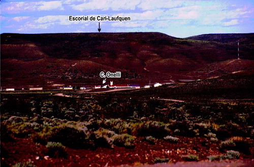
The geotectonic setting, geological history and plate tectonic evolution throughout time of the western side of the Rio Negro province as part of extra-Andean Patagonia has been summarized by CitationRamos (2008) and Citationvon Gosen (2009, see also references therein). From a geotectonic perspective, the Anecón Grande area is located between the Paleogene-Neogene thick-skinned fold-and-thrust belt of the North Patagonian Andes in the West (CitationGiacosa & Heredia, 2004) and the foreland Gondwanan basement rocks of the North Patagonian Massif in the East (CitationGonzález, 1998; CitationPankhurst, Rapela, Fanning, & Márquez, 2006; CitationVarela, Basei, Cingolani, Siga, & Passarelli, 2005). The most remarkable stratigraphic feature of the Anecón Grande area is a thick succession of intermediate to acidic volcanic and pyroclastic rocks from dissimilar tectonic settings (rift-related volcanism to continental arc magmatism), ranging from Late Triassic to Paleogene (see Main Map). These rocks unconformably cover igneous-metamorphic basement rocks which are composed of poorly exposed medium-to-high-grade metamorphic rocks of Devonian to Carboniferous protoliths intruded by calc-alkaline arc-related Early Permian granitoids. The basement rocks and their volcanic-pyroclastic cover are unconformably covered by thick and extensive basaltic lava flows of the Somuncura Plateau (Neogene to Quaternary) (CitationArdolino, Franchi, Remesal, & Salani, 2008 and references therein). In Patagonia, these lava flows form flat landforms similar to peneplains ( and ) that are colloquially named as ‘escoriales’, which means ‘surface made by scoria’ (CitationMazzoni & Rabassa, 2007). Minor outcrops of Cretaceous sedimentary rocks, including some red beds, are also present in the area.
Figure 4. The hamlet Clemente Onelli is located in the foothills of the flat landform named ‘Escorial de Cari-Laufquen’, which is composed of a thick pile of basaltic lava flows from Somuncura Plateau. This volcanic landform with steppe vegetation is typical for the extra-Andean Patagonian landscape.
3.1 Sites of geological interest
We selected seven out of 15 sites of geological interest to be considered as source areas of lithic materials for handicrafts and natural flagstones (). They were selected as notable sites given their ease of access and the presence of rocks with beautiful igneous textures or the ability of the rocks to split into thin sheets along planes of weakness. The full dataset still remains unpublished, but is available from the corresponding author on request. Numbers of the geological sites listed in , are shown on the geological map.
Table 1. Main sites of geological interest in the Anecón Grande area and surroundings, which can be considered as source areas of lithic materials. Numbers refer to geological sites and are also indicated on the geological map.
4. Conclusions
The geologic map presented here contains information about a thick succession of volcanic and pyroclastic rocks from the Anikhon Grande Mapuche reservation and surroundings. The map may be useful as a geological base, not only to plan new and more detailed petrologic and structural studies, but also to describe specific subjects of economic interest to the local community. Thus, the map as a tool, informs the reader of some geological deposits of igneous rocks and minerals suitable for manufacturing handicrafts and flagstones.
On the other hand, the map holds a special place in Patagonian awareness. The Anecón Grande area commonly evokes images of simpler times, in which, today, travelers of Interstate 23 may imagine the past. The area embodies a rich cultural and natural history with idiosyncratic features typical of the Patagonian landscapes. In this simple way, the map of the Anecón Grande area is a geological tour guide for an emblematic part of the foothills of the Andes from southern South America.
Software
The digital geological map of the Anecón Grande area was produced using Esri ArcGIST 9.3. Final map artwork was completed in CorelDraw Graphics Suite X4.
Geological Map of the Anecon Grande Area Patagonia (Rio Negro), Argentina
Download PDF (2.8 MB)Acknowledgements
We wish to express our thanks to R. Cucchi and A. Ardolino for helpful discussions on field trips. We are grateful to Dra. María Angélica Diez for providing insights on Mapuche bibliography. We also acknowledge IGRM-SEGEMAR (Instituto de Geología y Recursos Minerales, Servicio Geológico-Minero Argentino) for permission to publish the original Comallo geological map. We are also grateful to the reviewers, W. von Gosen, M. Trippi, and J. Abraham, whose comments contributed to improve the manuscript. The final English version significantly benefited by the kind and detailed assistance of M. Trippi and Natalia Irrazabal. This study was funded by IGRM-SEGEMAR (1993–1995) and by the project UNRN 40-B-125 (2011–2012), Universidad Nacional de Río Negro, Argentina.
References
- Amante, C., & Eakins, B. (2009). ETOPO1 1 Arc-Minute Global Relief Model: Procedures, Data Sources and Analysis. NOAA, Technical Memorandum NESDIS NGDC-24, 19 pp. Boulder (Colorado).
- Ardolino, A., Franchi, M., Remesal, M., & Salani, F. (2008). La Meseta de Somún Curá. Los sonidos de la piedra. Sitios de Interés Geológico de la República Argentina. CSIGA (Ed.). Instituto de Geología y Recursos Minerales, Servicio Geológico Minero Argentino, Anales 46 (54-II), 643–657. Buenos Aires.
- Aschero, C. (2000). El poblamiento del territorio. Nueva Historia Argentina, Tomo I: Argentina Pre-hispánica. In M. Tarragó (Ed.), Capítulo I (pp. 17–57). Buenos Aires: Editorial Sudamericana.
- Bengoa, J. (2000). Historia del Pueblo Mapuche. Siglos XIX–XX (6th ed.). Santiago: LOM Ediciones, 426pp.
- Coira, B., Franchi, M., & Nullo, F. (1985). Vulcanismo Terciario al oeste de Somuncura y su relación con el arco magmático de la Cordillera Norpatagónica, Argentina. 4° Congreso Geológico Chileno, 3(4), 68–88. Antofagasta.
- ERSDAC. (2010). ASTER GDEM. Available online from: http://www.gdem.aster.ersdac.or.jp
- Espósito, M. (2003). Diccionario Mapuche. Personajes de la Mitología. Toponimia indígena de la Patagonia. Nombres propios del pueblo Mapuche. Leyendas. Editorial Guadal, 350 pp. Buenos Aires.
- Feruglio, E. (1941). Descripción geológica de la Patagonia. Ministerio de Industria y Comercio. Dirección General de Yacimientos Petrolíferos Fiscales, Tomos 1, 2 y 3, CD-room. Buenos Aires.
- Giacosa, R., & Heredia, N. (2004). Structure of the North Patagonian thick-skinned fold-and-thrust belt, southern central Andes, Argentina (41°–42°S). Journal of South American Earth Sciences, 18(1), 61–72. doi: 10.1016/j.jsames.2004.08.006
- González, P. (1994). Mapa Geológico de la Provincia de Río Negro. República Argentina. Escala 1:750.000. Dirección Nacional del Servicio Geológico. Secretaría de Minería de la Nación. Buenos Aires.
- González, P. (1998). Geología y estratigrafía del magmatismo Fanerozoico de la Comarca Norpatagónica entre Comallo y Anecón Grande, Río Negro, Argentina. 10° Congreso Latinoamericano de Geología y 6° Congreso Nacional de Geología Económica 1, 78–83. Buenos Aires.
- González, P., Coluccia, A., & Franchi, M. (1999). Geología y Recursos Minerales de la Hoja 4169-III ‘Ingeniero Jacobacci’ (Provincia de RÍo Negro). Escala: 1:250.000. Servicio Geológico Minero Argentino. Subsecretaría de Minería de la Nación. Boletín N° 311. Buenos Aires. Unpublished.
- González Díaz, E., & Malagnino, E. (1984). Geomorfología. 9° Congreso Geológico Argentino. Relatorio, 13, 347–364. San Carlos de Bariloche.
- von Gosen, W. (2009). Stages of Late Paleozoic deformation and intrusive activity in the western part of the North Patagonian Massif (southern Argentina) and their geotectonic implications. Geological Magazine, 146(1), 48–71. doi: 10.1017/S0016756808005311
- Mazzoni, E., & Rabassa, J. (2007). Volcanic landscapes of Patagonia: A geomorphological map of the Piedra del Águila Volcanic Plateau, Province of Neuquén, Argentina. Journal of Maps, 3(1), 311–322. doi: 10.1080/jom.2007.9710847
- NASA. (2010). Shuttle Radar Topography Mission. Available online from NASA at: http://www2.jpl.nasa.gov/srtm/
- Pankhurst, R., Rapela, C., Fanning, C., & Márquez, M. (2006). Gondwanide continental collision and the origin of Patagonia. Earth Science Reviews, 76, 235–257. doi: 10.1016/j.earscirev.2006.02.001
- Rabassa, J. (1978). Estratigrafía de la región Pilcaniyeu-Comallo, Provincia de Rio Negro. 7° Congreso Geológico Argentino, 1, 731–746. Neuquén.
- Ramos, V. (2008). Patagonia: A paleozoic continent adrift? Journal of South American Earth Sciences, 26, 235–251. doi: 10.1016/j.jsames.2008.06.002
- Varela, R., Basei, M., Cingolani, C., Siga Jr., O., & Passarelli, C. (2005). El basamento cristalino de los Andes Norpatagónicos en Argentina: geocronología e interpretación tectónica. Revista Geológica de Chile, 32(2), 167–187.
- Wichman, R. (1934). Contribución al conocimiento geológico de los Territorios del Neuquén y Rio Negro. Dirección General de Minas, Geología e Hidrogeología, Boletín 39, 1–27. Buenos Aires.