
Abstract
The Tatra Mountains extend along the border between Slovakia and Poland in the Western Carpathians. It is the highest and formerly one of the most glaciated massifs in the entire Carpathian mountain chain. We present a paleoglaciological map of the Tatra Mts. and its foreland (ca. 1270 km2) for the Last Glacial Maximum (LGM) at the scale 1:50 000. We re-evaluate geomorphological evidence for all Tatra glacial systems identified in the literature based on new field mapping and remote sensing data analysis. Utilizing geographic information systems (GIS) and 10 m resolution digital elevation model (DEM) as a base topography, we have reconstructed, for the first time, the detailed extent and surface geometry of all Tatra LGM glaciers (55 glacier systems, total area ca. 280 km2) based on the distribution of glacial erosional and depositional landforms. Our research results confirm stronger glaciation on the southern slopes of the Tatras due to local topography. We also conclude that distinct morainic amphitheaters, which predominate on the southern side of the highest, eastern part of the Tatras, were formed by debris-covered glaciers.
1. Introduction
Well-designed maps to show the extent of former mountain glaciations have an especially long tradition in the European Alps (Bini et al., Citation2009; van Husen, Citation1987; Jäckli, Citation1962, Citation1970) where glacier limits and ice-surface geometry can be inferred from depositional ice-marginal landforms in the foreland as well from trimline evidence in the mountain interior (Florineth & Schlüchter, Citation1998; Kelly, Buoncristiani, & Schlüchter, Citation2004). The content of such maps is largely based on the compilation of many individual, local investigations and presents cumulative and comprehensive knowledge about Quaternary environments. The mapping of former glacier extent at a mountain range scale creates a unique opportunity to examine the interplay between topography, glacier distribution, and climate conditions (Florineth & Schlüchter, Citation2000; Haeberli & Penz, Citation1985). Such maps also help popularize science and educate society in general (Bini et al., Citation2009).
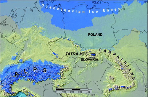
We present herein a map of glaciers and other environmental elements, such as ice-marginal landforms and glaciofluvial outflow, related to the Last Glacial Maximum (LGM) in the Tatra Mountains, which are situated in Central Europe midway between the former southern rim of the Scandinavian Ice Sheet and Alpine ice cover (). The Tatras were occupied by a relatively large number of glaciers. Therefore, glaciological reconstruction of this area is particularly interesting in relation to the glacial atmospheric circulation pattern in Europe (Florineth & Schlüchter, Citation2000; Makos & Nitychoruk, Citation2011; Mentlik, Engel, Braucher, Lèanni, & Team, Citation2013).
Figure 1. Location of the Tatra Mountains on a map of Quaternary glaciation limits in Central Europe. The LGM ice limit and mountain glaciers are indicated by a darker blue area. The most extensive ice limit during the Quaternary is indicated by a lighter blue area. Ice limits based on Ehlers, Gibbard, and Hughes (Citation2011, supplementary digital data, modified in the Western Carpathians); base topography – ETOPO (2009, http://www.ngdc.noaa.gov); sea surface lowered to −120 m.
2. Study area
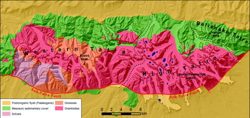
The Tatra Mountains (area ca. 778 km2) stretch longitudinally along the Polish-Slovak border in the Western Carpathians (49°17′–49°06′ N, 19°36′– 20°20′E). It is the highest and northernmost alpine-type range in the Carpathian chain. The Tatras no longer possess glaciers (Zasadni & Kłapyta, Citation2009) but bear well-marked traces of Pleistocene glaciations (Klimaszewski, Citation1988; Kotarba, Kaszowski, & Krzemień, Citation1987; Lukniš, Citation1973). The Tatras are usually divided into three parts according to their geological structure and relief characteristics: (1) Western Tatras (Bystrá, 2248 m), built of metamorphic, crystalline and sedimentary rocks with moderately developed glacial relief mostly confined to the highest, metamorphic and crystalline part in the south, (2) High Tatras (Gierlachovsky Štit, 2655 m), dominated by granites with typical alpine-type glacial relief, and (3) Belianske Tatry (Havran, 2152 m) built of sedimentary rocks with minor landscape modification by steep, small cirque-type glaciers (). Neogene uplift and tilting of the Tatra massif to the north along the Sub-Tatra Fault (Jurewicz, Citation2005; Kohút & Janák, Citation1994) have created distinct slope asymmetry between the two sides of the massif. As a result, valleys found on the southern slopes have steeper profiles and the bottoms of valley-head cirque basins are at higher elevations than northern valleys (Klimaszewski, Citation1960, Citation1965; Křižek & Mida, Citation2013; Lukniš, Citation1973).
Figure 2. Schematic geological map and geographic subdivision of the Tatra Mountains. Dashed-dotted line indicates national border; dashed lines mark geographic boundaries dividing the Tatra Mountains into three geographic regions; glacial lakes are depicted in blue.
3. Previous research
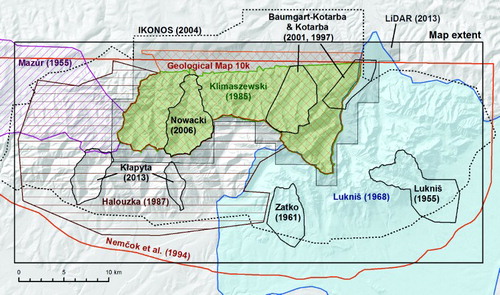
The glacial relief of the Tatra Mountains has interested scientists since the nineteenth century (Sonklar, Citation1857; Zejszner, Citation1856). According to pioneering research (Lucerna, Citation1908; Partsch, Citation1923; Romer, Citation1929), the Tatra Mountains were covered by an extensive ice cap during the ‘Ice Age’. Further studies demonstrated unequivocally that the glaciation was characterized by alpine-type valley and cirque glaciers. In the second half of the twentieth century, great advances were made in the detailed mapping of the glacial landsystem of the Tatra Mountains; however, most investigations were focused on the High Tatras. Two monographs on Tatra relief provide key insight on Tatra glaciations: (1) Lukniš (Citation1973) for the Slovak part of the High Tatras and its foreland, and (2) Klimaszewski (Citation1988) for the Polish Tatras. The two books are supplemented with detailed geomorphological maps at a scale of 1:50,000 (Lukniš, Citation1968) and 1:30,000 (Klimaszewski, Citation1985) (). Glacier extent during the last glaciation is also shown on a map by Halouzka (Citation1987) for the Slovak part of the Western Tatra Mountains. The geological map by Nemčok et al. (Citation1994, scale 1:50,000) shows Quaternary sediments throughout the entire Tatra Mountains. The Quaternary content of this map was partially based on the above mentioned geomorphological maps. Nevertheless, it shows only the extent of glacial sediments (till) with no sign of moraine ridges, which hampered its use to identify the exact extent of glaciation. For the Polish Tatra Mountains, glacial sediments are presented on a geological map at a scale of 1:10,000 (Geological Map of the Polish Tatra Mountains, 14 sheets). Small scale, schematic paleoglaciological maps depicting the extent of glaciers found throughout the entire Tatras were published by Klimaszewski (Citation1960, Citation1965), Lukniš (Citation1964) and Lindner, Dzierżek, Marciniak, and Nitychoruk (Citation2003). Geomorphic records of glaciations were also presented in detail for individual glaciated valley systems: Lukniš (Citation1955), Mazúr (Citation1955), Zatko (Citation1961), Baumgart-Kotarba and Kotarba (Citation1997, Citation2001), Nowacki (Citation2006) and Kłapyta (Citation2013) (). Previous reconstructions of ice-surface geometry of LGM glaciers were carried out only for the Mała Łąka glacier (Gądek, Citation1998) and Białka and Sucha Woda glaciers (Makos & Nitychoruk, Citation2011) in the Polish Tatras. The geomorphological traces of glaciations in many valleys remain poorly documented, especially in the Western and Belianske Tatras. Additionally, large discrepancies exist in the literature regarding LGM glacier extent in some valley systems (e.g., Tichá Valley; Halouzka Citation1987; Lukniš, Citation1964; Mastalerz-Klimaszewska & Klimaszewski, Citation1938; Nemčok et al., Citation1994).
Figure 3. Spatial extent of previous geological and geomorphological maps, which contain information on glacial landforms and deposits, and the extent of remote sensing data utilized in this study: IKONOS (2004) – Ikonos satellite multispectral image taken in August of 2004, 1 m resolution (source: Tatra National Park, Poland); LiDAR (2013) – 1 m resolution DEM from laser scanning (source: CODGIK, Poland); Geological Map 10 k – Geological Map of the Polish Tatra Mountains at a scale of 1:10 000, 14 sheets (1958–1978), S. Sokołowski & K. Guzik (Eds), Wydawnictwa Geologiczne, Warszawa.
The numerical dating of glacial landforms and sediments in the Polish High Tatras (Baumgart-Kotarba & Kotarba, Citation2001; Dzierżek, Nitychoruk, Zreda-Gostyńska, & Zreda, Citation1999; Makos, Nitychoruk, & Zreda, Citation2013) indicates that glaciers reached their maximum extent during the last glacial cycle, not earlier than 28 ka and abandoned this position ca 21 ka, which falls well within the LGM period (Clark et al., Citation2009; Lambeck, Yokoyama, & Purcell, Citation2002). In most cases, the spatial extent of LGM glaciers is comparable with previous glacial maxima; however, at some locations on both sides of the High Tatras, weathered till cover with subdued relief is preserved beyond the distinct moraines of the last glacial cycle. This well-defined difference in relief freshness of glacial deposits () allowed previous researches to distinguish two common glaciations in the Tatra Mountains – last and penultimate (classical alpine Würm and Riss – Baumgart-Kotarba & Kotarba, Citation1997; Klimaszewski, Citation1988; Partsch, Citation1923). Additionally, Lukniš (Citation1973) proposed a ‘Mindel age’ for older till cover found at one location – the mouth of Studená Valley (). In contrast, Lindner et al. (Citation2003) suggested eight glaciations in the Tatras based on the morphostratigraphy of glaciofluvial deposits found across the Tatra foreland (Halouzka, Citation1992; Nemčok et al., Citation1994).
Figure 4. A. Relief characteristics of LGM and most extensive (pre-LGM) glacial deposits using an example from the mouth of Białka Valley. The Rusinowa Polana meadow is a classical site of the most extensive till cover in the Tatras; I-III – moraines related to the LGM. B. The difference in relief roughness between pre-LGM and LGM till cover enhanced by the topographic position index (Jenness, Citation2006) derived from LiDAR DEM; blue areas stand above and red below a mean elevation calculated in 25 m radius.
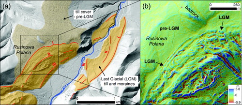
Figure 5. Studená Valley morainic amphitheater. A. Schematic map by Lukniš (Citation1968 – a part of the map, which supplements a detailed geomorphological map at a scale of 1:50 000). The map shows complex chronology of repeated glacial advances during the last glaciation (Würm) stadial oscillations: A (Rakytovec), B (Stosy), C (Tatranská Lomnica), D (Veza); penultimate glaciation Rs (Riss); and oldest glaciation Mn (Mindel). B. Perspective view of the Studená Valley morainic amphitheater with highlighted geometry of the latero-frontal dump moraine complex formed by a debris-covered glacier (Google Earth ®, vertical scale two times exaggerated; image: Digital Globe): 1 – latero-frontal dump moraines, 2 – secondary morainic lobes, 3 – hummocky moraine, 4 – abandoned outwash channels on moraine slope.
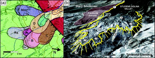
In Białka Valley well-preserved latero-frontal moraines indicate three main oscillations of the glacier tongue close to its maximal position during the last glaciation (Baumgart-Kotarba & Kotarba Citation2001) (). According to Lukniš (Citation1959, Citation1964, Citation1973), the system of prominent morainic amphitheaters preserved on the southern foreland of the High Tatras is composed of moraines attributed to four oscillation of a stadial nature (Rakytovec, Štosy, Tatranská Lomnica and Veža), which have taken place from the Early to Late Würm (MIS 5d – MIS 2) (). In later work (Halouzka, Citation1987; Lindner et al., Citation2003; Nemčok et al., Citation1994), the moraines assigned by Lukniš (Citation1973) to the Rakytovec stadial were attributed to the penultimate glaciation (MIS 6). However, it should be emphasized that the chronological position of these four stadials of the last glaciation as well as the age of the older till cover were suggested only on the basis of morphostratigraphy, visually defined degree of till weathering, and tentative correlation with Northern Europe and Alpine records (Hercman, Citation2000), but no numerical dating analyses were performed.
4. Methods, data collection, and map elements description
4.1. Topographic base
We utilized a digital elevation model (DEM) derived from photogrammetric measurements made in 2009 by the Center for Geodesy and Cartography of Małopolska Voivodeship (Kraków) and the Spatial Databases Division of Tatra National Park (TPN) as our topographic base in the main map. This DEM (hereafter called ‘base DEM’) features 10-m horizontal resolution and is used as a source of altitudinal information for mapped geomorphological features and as a background for the glacier reconstruction. It is the highest-resolution DEM currently available for the study area; however, for some parts of this DEM it was necessary to update it using a new DEM derived from the digitalization of topographic maps. This update was especially necessary for the southern slopes of the High Tatras where the original DEM surface portrayed the forest border line. A background shaded relief map, as well as 50 m interval contours presented in the map, were derived from the base DEM. For better cartographic presentation, smaller artifacts on the base DEM surface (sinks, DEMs merging break lines) were also cleaned up in the shaded relief raster. For the Polish Tatra Mountains, we also used a 1 m resolution DEM derived from laser scanning data (LiDAR – source: CODGIK, http://www.codgik.gov.pl/) for mapping purposes. However, this model is not presented in the map for the sake of consistency with the base topography across the entire map.
4.2. Glaciers
The map presented shows several environmental elements, but its main content consists of glaciers. The extent and ice-surface geometry of former glaciers are reconstructed on the basis of geomorphological evidence. Spatial data on glacier limits were obtained from three sources: (i) authors’ detailed geomorphological mapping and field inspection, (ii) previous literature reports, particularly detailed maps dealing with glacial landforms and sediments, (iii) results of DEM, LiDAR and remote sensing image analysis – Google-Earth, webGIS orthophotos (geoportal.gov.pl, geoportal.gov.sk) and IKONOS satellite data (). Previous maps were scanned, georeferenced, and critically analyzed by comparing them with field results and remote sensing data. Data collection, georeferencing, digitization, analysis, and final map layout design were all performed within a geographical information system (GIS).
4.2.1. The LGM glacier extent and ice-marginal landforms
Glacier limits on the map presented follow the most distal (outer) moraines associated with the well-preserved and apparently young glacial depositional system from the last glaciation period. In accordance with the literature, we assumed that these moraines were formed during the LGM (MIS 2). Prominent outer moraine walls and ramps are often composed of multiple, superimposed, nested moraine crests. This means that in detail (which are mostly too small for representation at this map scale), the presented glacier limit is diachronic. Nevertheless, it is reasonable to show on the map glacier extent following the inner LGM moraines in Bystra and Mengusovská Valleys, where the outer moraines stand much lower than the high inner ones and where distance between these moraines is considerable (>100 m). In these cases, the outer LGM moraines are shown beyond the LGM glacier limit.
The most extensive till cover (pre-LGM in age), which commonly occurs beyond the outer glacial landforms (LGM in age) in the High Tatra Mountains, is not depicted on the map. Smaller glaciated valleys, particularly in the Western and Belianske Tatra Mountains, mostly do not reveal geomorphological evidence of these two glacial limits. In such a case, we assumed that the most extensive limit of glacial deposits belongs to the LGM morainic system. We also assumed that all of the cirques or slope hollows with less evident signs of glacial remodeling (niches) had been occupied by glaciers during the LGM. In the case of small glaciated valleys, cirques and niches that do not bear clear depositional landforms (e.g., Ostredok; Vel'ky Žl'ab; Jaworzynka Val.), the extent of glaciers was roughly fitted to the visible extent of glacial erosional modification of valley morphology (flattening of valley bottom, U-shaped cross-profile of valley).
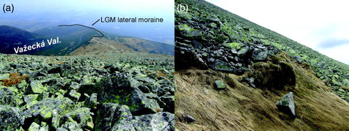
We used a different approach than Lukniš (Citation1968, Citation1973) to identify glacier extent in the southern foreland of the High Tatras where prominent morainic amphitheaters dominate in the glacial depositional system. Mapped latero-frontal dump moraine complexes reveal multi-lobed geometry with common secondary lobate termini and broad embayments resulting from the breaching of the main moraine barrier. The high distal slopes of these moraines (commonly tens of meters high) and the presence of dead-ice (hummocky) topography across the moraine surface clearly indicate that this landsystem is typical of debris-covered glaciers (Benn & Evans, 1998; Benn, Kirkbride, Owen, & Brazier, Citation2003; Owen & Derbyshire, Citation1989; ). This interpretation is also supported by the large proportion of the ablation zone area with respect to the entire glacier area (low accumulation area ratio; c.f. Benn & Lehmkuhl, Citation2000), which can be roughly estimated for some glaciers based on the distribution of lateral moraines (e.g., Važecká, Skalnatá and Sucha Woda valleys). Therefore, on our map, we link all of the lateral embayments and secondary lobes associated with morainic amphitheaters into one morphological system. For simplification, this system is assumed to be developed at the same time (LGM), as can be observed in present-day debris-covered glaciers (e.g. Miage glacier in the Italian Alps: Deline & Orombelli, Citation2005). It should be noted that, contrary to the approach presented above, Lukniš (Citation1973) proposed a complex stratigraphy of the High Tatras' morainic amphitheaters which appear to be based on a paradigm that treated secondary lobes as morphological evidence of repeating glacial advances, which successively changed the main outflow route. The consequence of this approach was that each prominent secondary lobe was attributed to a different glacial advance (i.e. different Würm stage), providing the core of Lukniš’s (1973) last glaciation stratigraphy. Recent results of the Schmidt-hammer test at the classic location of Lukniš’s (1973) last glacial stages in the Studená Valley moraine amphitheater do not indicate statistically significant differences between weathering rates for morainic boulders (Mida & Křižek, Citation2013), which also supports the glacier geometry shown on our map.
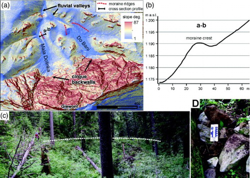
We recognize morphological evidence for seven small glacier systems, which have not been reported previously on paleoglaciolgical maps; five systems in the Polish part (Dudowa, Mała Dolinka, Do Bani, Sucha and Jaworzynka Valleys; ) and two systems in the Slovak part of the Tatras (Ostredok, and Vel'ky Žl'ab Valleys; details in supplementary data 1A, B). All of these glaciers belong to the smallest glaciers in the entire set of the Tatras glaciers, but even the smallest of them was longer than 500 m, which is much greater than the critical threshold size of a glacier ice body (30–70 m) indicated by Ballantyne and Benn (Citation1994). The size of the smallest reconstructed glaciers (several hundred of meters) can imply the minimum size of ice body which is sufficient to apparently modify preglacial (fluvial) relief. Depositional landforms of four glaciers in the Polish Tatras (supplementary data 1A) were recognized in light of analysis of the newly available LiDAR DEM and were confirmed in the field. They are composed of boulders mostly of allochtonous lithology (Jurassic/Cretaceous massive limestone boulders of headwater rockwall provenance on Triassic dolomitic bedrock). Glacial deposits in Dudowa, Mała Dolinka and Do Bani Valleys were also depicted on the geological map of Rabowski (Citation1953) but glaciers in these locations were never shown on previously published paleoglaciological maps.
Figure 6. Geomorphological evidence of glaciation found on the northern face of Mount Giewont; an example of glaciation evidence not previously reported in geomorphological and paleoglaciological maps: A. Slope map (derived from LiDAR DEM) showing flat-floored valley-heads and semicircular oversteepened backwalls engraved on the foot of structural rock wall of Mount Giewont; moraine crests are depicted as red dashed lines; B. Cross section profile (a-b) of the right terminal moraine in the Mała Dolinka valley. The location of cross-section a-b is shown in the panel (a); C. Crest line (white dashed line) and distal slope of the right lateral moraine of the Mała Dolinka glacier; D. Sub-angular to sub-rounded allochtonous limestone boulders on the surface of moraine relics (fresh excavation)
The literature also suggests the existence of six small glacier systems (a-f signature in supplementary data 1A, B) for which we cannot confirm geomorphological evidence, and they are not presented on the map. In light of new data, the geometry of many larger glaciers has been changed in relation to previously published maps. A brief description of the geomorphological records of all presented glaciers with an explanation of relevant changes, modification, and alteration of glacier extent in comparison with previous work is summarized in the supplementary data 1.
Ice-marginal landforms marked on the map are shown at sites where they were confirmed in the field or are clearly discernible using digital data. It is worth noting that, as a result of a great blowdown (Velká kalamita) that took place in November 2004, large areas of the southern foreland of the High Tatra Mountains were totally cleared of forest cover (Motyčka, Citation2005). Therefore, the most moraine-abundant landscape in the Tatra Mountains became broadly exposed for the first time, which has helped in geomorphological studies.
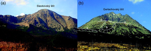
The legend includes several types of ice-marginal landforms. We distinguish ‘distal slopes of dump moraines’ where moraine slopes are long/high enough to show them at this map scale (). Such moraines usually embanked debris-covered glaciers. A ‘moraine’ signature indicates moraine crests or moraine terraces, which are well-preserved and documented, but in the case of ‘moraines’ distal slopes are not mappable at the map scale. In addition, we identified ‘discontinuous moraines and glacial drift limits’ that indicate poorly developed/preserved and discontinuous moraines or the extent of glacial deposits on valley slopes (glacial drift limit). ‘Rock glacier lobes associated with moraines’ indicate coarse bouldery masses in lobate landforms with ridge and furrow relief on the surface and with steep margins mantled with aprons of debris. Mapped relict rock glacier bodies reveal a clear spatial relationship with the LGM moraines, thus they were interpreted as a breach of lateral moraine walls under periglacial conditions (remobilized moraine material due to permafrost creeping; Vere & Matthews Citation1985; Whalley, Citation2012). Relict rock glaciers associated with LGM morainic system were identified only at two sites on the southern slopes of the High Tatras (Batižovská valley and Grerlachovský kotol cirque; ).
Figure 7. Ice-marginal landforms on the southern slope of the High Tatra Mountains: A. typical high moraine ramps in Velická and Slavkovská Valley; B. Relict rock glaciers associated with LGM moraines: a – steep frontal slope of the relict rock glacier lobe associated with the left lateral moraine of the Batižovská Valley glacier; b – relict rock glacier tongue (c.f. Lukniš, Citation1973) associated with the latero-frontal moraine at the outlet of the Grerlachovský kotol cirque (c). This moraine belongs to the LGM moraine system and the top (left) reaches the extraordinarily high elevation of 2120 m in entire Tatra Mountains.
4.2.2. Ice elevation record – trimlines
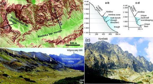
In the upper parts of glaciated valley systems, where ice accumulation and erosion dominate over ablation and moraine deposition, the vertical extent of ice-surfaces can be assessed only on the basis of the interpretation of erosional landforms such as glacial trimlines (Ballantyne, Citation2013; Florineth & Schlüchter, Citation1998; Kelly et al., Citation2004). Well-developed glacial trimlines are preserved commonly in larger troughs in the High Tatra Mountains (Makos & Nitychoruk, Citation2011; Makos et al., Citation2013), whereas in the Western Tatras, glacial trimlines are less clearly developed, with some exceptions (Studený potok and Starorobociańska Valley). Field observations, DEMs, and remote sensing images were used to map trimlines found in glacial troughs and clearly developed oversteepened parts of cirque back walls. shows examples of these glacial erosional landforms and illustrates the assumption of reconstructed ice-surfaces adopted in this study.
Figure 8. Trimlines and cirque backwall morphology as an ice-elevation record in the upper parts of glaciated valleys: A. Slope map (derived from LiDAR DEM) of a part of Roztoka Valley and hanging tributary cirque (Buczynowa Valley). The map shows a typical trimline in a glacial trough, which is discernible as a steeper (several tens of meters high) rock wall (trimline zone) standing between a gentler sloping rock bench below and rugged terrain above (profile a-b). The trimline gradually transits into the oversteepened lower part of the cirque backwall (profile c-d) in the Buczynowa Valley cirque. In this study, the maximum vertical extent of LGM glaciers is assumed to be found at the upper edge of trimline zones in troughs and the upper edge of backwall oversteepings in cirques, as shown in profiles a-b and c-d; B. Cirque backwall engraved in gentler sloping terrain. Note blockfield on slope above the cirque edge (Kobyla Valley cirque, which is the right-hand tributary of Koprova Valley, located south of Gładki Wierch Mountain). This type of cirque is typical of the Western Tatras; C. Oversteepened lower part of cirque backwall typical of High Tatras – example of Batižovská Valley cirque. Note rugged rocky terrain above the oversteepened rock wall. Arrows in photographs B and C indicate the maximum vertical position of glacial influence on terrain.
We follow Alpine literature (e.g. Florineth & Schlüchter, Citation1998; Kelly et al., Citation2004) which relates glacial trimline with the upper limit of glacier surface rather than with the thermal regime boundary in ice (thermal trimline) evidenced in lower-relief mountains covered in the past by ice-caps or ice-sheets (e.g., Fabel, Ballantyne, & Xu, Citation2012 and references therein). Major scale erosional landforms such as troughs and cirques have developed during succeeding Pleistocene glaciations. Inferring from glacial deposits, glaciations older than the LGM were locally more extensive than the LGM glaciation. Therefore, it is reasonable to assume that mapped glacial trimlines mark the maximum approximation of the LGM ice-surface position. On the other hand, considerable overestimation of LGM ice extent at trimlines can be caused if considering a relatively small, or no, offset distance between pre-LGM and LGM Tatra glacier snouts.
The assumption adopted in this study, which relates all glacial erosional landforms with the LGM glacier extent, cannot be applied to the Tichá Valley. This valley features a 4 km long section of well-developed (U-shaped) glacial trough down valley from the LGM glacier terminus. This is the one glacial trough in the Tatra Mountains which had not been fully occupied by an LGM glacier (c.f. Mastalerz-Klimaszewska & Klimaszewski, Citation1938). Thus, this trough has to have developed earlier than the last glacial cycle. It is worth noting, that on the map presented the extent of Tichá Valley glacier during the LGM follows the most extensive scenario in the literature (Halouzka, Citation1987; Nemčok et al. Citation1994). We link this glaciation's extent discrepancy with a specific constellation of glaciated valleys around the Tichá Valley, where during the LGM five glaciers formed (Tichá, Kôprová, Kamenistá, Hlina, and Kôprovnica), with terminuses very close to one another. In such a topographic setting, glaciers during pre-LGM glaciations were able to expand and erode much further beyond the LGM position than in other Tatras valleys due to coalescence. We can speculate that this could happen even with a small drop of ELA in relation to the LGM condition or at an earlier stage of glacial landscape evolution (lower depth of glacial trough incision in earlier glaciations) (c.f. Anderson et al., Citation2012). There are remnants of pre-LGM till cover around Kôprová and Kamenistá Valley mouths (Halouzka, Citation1987; Lukniš, Citation1968) suggesting such glaciers coalesced (Halouzka, Citation1987). We can infer that this pre-LGM glacier coalescence created probably the largest Pleistocene glacier system (ca. 50 km2) in the Tatra Mountains.
4.2.3. Ice-surface reconstruction
We drew ice-surface contour lines mostly at 25 m equidistance following the spatial distribution of moraines in ablation zones and trimlines and cirque back walls in accumulation zones. The shape of the contours mimic real-glacier ice surface geometry, which is concave in the accumulation zone and convex in the ablation zone (Hughes, Citation2011). Ice-surface contour lines with an altitude attribute were then used to interpolate the DEM of glacier surface using the same spatial resolution as the base DEM (10 m). The DEM of each glacier was derived separately. The exact extent of the glacier surface fitted to the base DEM was obtained by computing clipping masks for glacier DEMs utilizing the logical relationship between the base DEM and the glacier DEMs. Ice surface contours and ice-surface shaded relief presented in the map layout were then derived from the glacier DEMs.
4.2.4. Glacier surficial structures
For better graphical presentation of ice motion and snow and debris transport across glaciers, the presented map includes some glacier surficial structures. Their presence and geometric characteristics could be inferred by analogy with real glaciers, but in most cases surficial structures cannot be directly read from the geological record. The ‘crevasse’ pattern is drawn following Nye's (Citation1952) rule to imitate extensive and compressive glacier flow dynamics. In accumulation zones and on prominent bedrock thresholds, crevasses curve across glaciers and are concave towards the down flow direction (extensive flow). In the ablation zone, where compressive flow dominates, crevasses are transversally oriented to ice flow direction at an angle of less than 45° to the glacier margin and splaying crevasses occur near glacier terminuses (c.f. van der Veen, Citation2011). ‘Medial moraines’ (discontinuous debris cover) are depicted to show the probable distribution of flow unit boundaries, especially on trunk glaciers with significant affluents. Medial moraines are an indicator of the ablation zone, and they occur below the glacier equilibrium line (ELA). Therefore, the maximum vertical extent of medial moraines shown on the map follows our rough approximation of glacier ELAs. However, a detailed calculation of glacier ELAs using the presented data is beyond the scope of this work and we have left it for further research. ‘Continuous debris cover’ on glacier surfaces (debris-covered glaciers) is depicted in the terminal zones of these glaciers, which left distinct moraine complexes featuring dead-ice topography (see section 4.2.1.). ‘Snow avalanche supply’ indicates zones on glacier surfaces below prominent ravines or steep non-glaciated walls and slopes, which had been most likely a significant source of snow avalanches.
4.3. Periglacial blockfields
Large areas of the Tatra Mountains, particularly the southern slopes of the High Tatras, are covered with blockfields (openwork angular blocks) as well as fine-grained regolith with blocks (Ballantyne Citation2010). Blockfields occur on slopes and gently undulating water divide surfaces, mostly restricted to elevations above 1500 m (). We interpret the presence of blockfields as the product of weathering and frost sorting under long-term periglacial conditions at high elevations, mainly above the lower limit of the Pleistocene ELA, where topographic settings were not suitable for ice accumulation. The spatial extent of blockfields was digitized using remote sensing images. A false color composite of IKONOS bands 2, 3, and 4 were particularly valuable in this task.
Figure 9. Periglacial blockfields: A. Granite blockfield on the southern slope of Kriváň Mountain (High Tatras), which developed through in situ weathering (autochthonous blockfied, Ballantyne, Citation2010); B. Granite blockfield on the slope of Jarząbczy Wierch Mountain (Western Tatras), partially mobilized (blockstreams, solifluction lobes; allochthonous blockfield).
4.4. Glaciofluvial and fluvial floodplains and fans
The map presents glaciofluvial plains and fans associated with glacial meltwater and alluvial terraces supplemented with signatures of braided river channels. The spatial extent of this feature encompasses last glacial to Holocene water-laid deposits, which had been depicted on previously published geological and geomorphological maps (Klimaszewski, Citation1985; Lukniš, Citation1968; Mazúr, Citation1955; Nemčok et al., Citation1994). The extent of this feature has been digitized and in some cases altered to fit the base DEM topography and new glacier configurations. We also depict larger torrential cones, which occur mostly at the mouth of some unglaciated catchments (after Nemčok et al., Citation1994 with modification).
4.5. Vegetation
The present-day timberline reaches an elevation of 1550 m on the northern (Obidowicz, Citation1996), and 1650 m on the southern slopes (Plesník, Citation1971) of the Tatra Mountains. Discontinuous permafrost could occur as low as 800 m during the last full glacial conditions in the Western Carpathians (Orvošová, Deininger, & Milovský, Citation2013). Taiga-type open forest along with steppe-tundra elements survived the glacial climax in well-protected and relatively humid Carpathian valleys at lower elevations (Jankovská & Pokorný, Citation2008). Forest expanded on the Tatras foreland in the Lateglacial period (e.g. Obidowicz, Citation1996); however there is still a lack of any paleobotanical site which would provide information about vegetation around the Tatra Mountains during the full LGM condition. We assume that the region surrounding the Tatra Mountains was dominated during the LGM by treeless vegetation characterized by steppe-tundra and alpine tundra. The map shows a decline of vegetation (tundra) between 1200 and 1400 m, which is below the lowest limit of the LGM ELA, roughly estimated at 1400 m of elevation (Gądek, Citation1998; Halicki, Citation1930; Makos & Nitychoruk, Citation2011).
4.6. Topographic names
Topographic names were obtained from topographic maps: Vysokè Tatry (1999) and Západne Tatry (1999) (scale 1:25 000, Edicia turistických máp Vojenský kartografický ústav, Harmanec). Polish language toponyms are used for the Polish part of the map area and summits located along the Polish-Slovak state border. Slovak language toponyms are used for Slovak part of the map area. Names of glaciers follow names of valleys and glacial cirques. Large cirque-type ice basins found at high elevations are depicted as ‘cirque ice-fields’.
5. Discussion and conclusions
Our map shows the detailed extent and ice-surface geometry of all glaciers which existed during the LGM in the Tatra Mountains. Our result indicates that during the LGM, the Tatra Mountains were covered by 55 valley and cirque glaciers, which occupied a total area of 279.6 km2 (). The glaciers' area-averaged thickness was 88 m. There were nine glaciers of more than 10 km2 and 8 km in length, and they covered 63.5% of the total glaciated area (177.5 km2). The total area of glaciers that occupied the southern slopes (148.5 km2) was larger than those occupying the northern slopes of the Tatras (126.8 km2 without Belianske Tatras – 4.3 km2). Most glaciers descended to an elevation range of 1000–1250 m; however, eight glaciers descended below 1000 m – two on the northern side (Studený potok and Białka glaciers) and six on the southern side (Bystrá, Kôprová, Mengusovská, Batižovská, Studená and Kežmarskej Bielej Vody glaciers). While the Białka glacier found on the northern slope was the largest of the glaciers in every respect (area: 43.6 km2, length: 13.4 km, max. thickness: ca. 400 m, terminus elevation: 914 m), the southern slopes of the Tatras were usually occupied by longer glaciers that tended to descend lower than glaciers on the northern slopes. This glaciation asymmetry can be linked to distinct topographic asymmetry resulting from the northward tilting of the Tatra Mountains. This resulted in southern-facing valley heads being found at higher elevations (more than 2000 m). Reconstructed glacier geometry – in many cases – reveals ice-surfaces of southern-facing glaciers found 200 to 250 m higher than those of northern-facing glaciers. These high-altitude ice-surfaces most likely served as capacious, high alimentation rate areas for southern-sloping glaciers (Klimaszewski, 1962). Moreover, the geometric properties of ice-marginal landforms created by glaciers found on the southern side of the High Tatras indicate that the termini of these glaciers were debris-covered. Inefficient ablation underneath debris-cover further exacerbated the earlier described glaciation asymmetry, as debris-covered glaciers with enlarged ablation areas (Benn & Lehmkuhl, Citation2000) were able to descend lower than ‘clean glaciers’.
Table 1. S-N slope glaciation asymmetry and selected morphometrics of reconstructed LGM glaciers in the Tatra Mountains.
Software
ESRI ArcGIS 10.1 was used for map production. This includes data collection, georeferencing, digitizing, images and DEMs analysis, to final layout composition (ArcMap) and perspective visualization (ArcScene). Google Earth was used for part of the mapping. This work was saved as a KML file and imported in to ArcGIS as a shapefile. Corel Paint Shop Pro was used to clean some artifacts in a shaded relief raster of the base DEM.
Main Map: The Tatra Mountains During the Last Glacial Maximum
Download Zip (20.8 MB)Acknowledgements
We would like to thank A. Świąder for his valuable advice on GIS solutions used in this study and M. Guzik for granting access to GIS data (10 m DEM, IKONOS) from the Tatra National Park spatial database. This paper and the map benefited greatly from reviews by B. Jenny P. Migoń and I.S. Evans; and helpful suggestions of production editor T. Meets. This research study was supported by AGH University of Science and Technology statutory grant 15.11.140.040 assigned to J. Zasadni and Jagiellonian University statutory grant K\DSC\001758 assigned to P. Kłapyta.
References
- Anderson, R. S., Dühnfortha, M., & Colgand, W. (2012). Far-flung moraines: Exploring the feedback of glacial erosion on the evolution of glacier length. Geomorphology, 179, 269–285. doi: 10.1016/j.geomorph.2012.08.018
- Ballantyne, C. K. (2010). A general model of autochtonous blockfield evolution. Permafrost and Periglacial Processes, 21, 289–300. doi: 10.1002/ppp.700
- Ballantyne, C. K. (2013). Glacial Landforms, ice sheets: Trimlines and Paleonunataks. In S. A. Elias & C. J. Mock (Eds.), Encyclopedia of quaternary science (Second Edition) (pp. 918–929). Amsterdam: Elsevier. doi:10.1016/B978-0-444-53643-3.00080-7
- Ballantyne, C. K., & Benn, D. I. (1994). Glaciological constraints on protalus rampart development. Permafrost and Periglacial Processes, 5, 145–153. doi: 10.1002/ppp.3430050304
- Baumgart-Kotarba, M., & Kotarba, A. (1997). Würm glaciation in the Biała Woda Valley, High Tatra Mountains. Studia Geomorphologica Carpatho-Balcanica, 31, 57–81.
- Baumgart-Kotarba, M., & Kotarba, A. (2001). Deglaciation in the Sucha Woda and Pańszczyca Valleys in the Polish High Tatra. Studia Geomorphologica Carpatho Balcanica, 35, 7–38.
- Benn, D.I. & Evans, D.J.A. (1998). Glaciers and glaciation. London: Arnold.
- Benn, D. I., Kirkbride, M. P., Owen, L. A., & Brazier, V. (2003). Glaciated valley landsystems. In D. J. A. Evans (Ed.), Glacial landsystems (pp. 372–406). London: Arnold.
- Benn, D. I., & Lehmkuhl, F. (2000). Mass balance and equilibrium-line altitudes of glaciers in high-mountain environments. Quaternary International, 65, 15–29. doi: 10.1016/S1040-6182(99)00034-8
- Bini, A., Buoncristiani, J. F., Couterrand, S., Ellwanger, D., Felber, M., Florineth, D., … Schoeneich, P. (2009). Die Schweiz während des letzteiszeitlichen Maximums (LGM). Map 1: 500 000, swisstopo.
- Clark, P. U., Dyke, A. S., Shakun, J. D., Carlson, A. E., Clark, J., Wohlfarth, B., … McCabe, A. M. (2009). The Last Glacial Maximum. Science, 325, 710–714. doi: 10.1126/science.1172873
- Deline, P., & Orombelli, G. (2005). Glacier fluctuations in the western Alps during the Neoglacial, as indicated by the miage morainic amphiteatre (Mont Blanc massif, Italy). Boreas, 34, 456–467. doi: 10.1111/j.1502-3885.2005.tb01444.x
- Dzierżek, J., Nitychoruk, J., Zreda-Gostyńska, G., & Zreda, M. (1999). Metoda datowania kosmogenicznego izotopem 36Cl – nowe dane do chronologii glacjalnej Tatr Wysokich. Przegląd Geologiczny, 47(11), 987–534.
- Ehlers, J., Gibbard, P. L., & Hughes, P. D. (2011). Quaternary Glaciations - Extent and chronology: A closer look. Developments in quaternary science. Amsterdam: Elsevier.
- Fabel, D., Ballantyne, C. K., & Xu, S. (2012). Trimlines, blockfields, mountain-top erratics and the vertical dimensions of the last British–Irish Ice Sheet in NW Scotland. Quaternary Science Reviews, 55, 91–102. doi: 10.1016/j.quascirev.2012.09.002
- Florineth, D., & Schlüchter, C. (1998). Reconstructing Last Glacial Maximum ice surface geometry and flowlines in the central Swiss Alps. Eclogae Geologicae Helvetiae, 91, 391–407. doi:10.1007/s00015-004-1109-6
- Florineth, D., & Schlüchter, C. (2000). Alpine evidence for atmospheric circulation patterns in Europe during the Last Glacial Maximum. Quaternary Research, 54, 295–308. doi: 10.1006/qres.2000.2169
- Gądek, B. (1998). Würmskie zlodowacenie Tatr w świetle rekonstrukcji lodowców wybranych dolin na podstawie prawidłowości glacjologicznych. Prace Naukowe Uniwersytetu Śląskiego, 1741, Katowice.
- Haeberli, W., & Penz, U. (1985). An attempt to reconstruct glaciological and climatological characteristics of 18 ka BP Ice Age glaciers in and around the Swiss Alps. Zeitschrift für Glazialkunde und Glazialgeologie, 21, 351–361.
- Halicki, B. (1930). Dyluwialne zlodowacenie północnych stoków Tatr. Sprawozdanie Polskiego Instytutu Geologicznego, 5(3–4), 375–534.
- Halouzka, R. (1987). Stratigrafia a geologicko-paleontologický vývoj kvartéru Slovenska v Západných Tatrách., Manuscript, Archive GUDŠ, Bratislava.
- Halouzka, R. (1992). Survey of Pleistocene mountain glaciations in the Tatra Mts. (with glacial stratigraphy of the Tatra Mts. In European correlation) and their parallelization with Continental glaciations in the Northmoravian Silesian region. Scripta Fac. Sci. Univ. Masaryka, Geologia, Brno, 22, 101–107.
- Hercman, H. (2000). Reconstruction of paleoclimatic changes in Central Europe between 10 and 200 thousand years BP, based on analysis of growth frequency of speleothems. Studia Quaternaria, 17, 35–70.
- Hughes, P. D. (2011). Palaeoclimate and past glaciations. In V. P. Singh et al. (Eds.), Encyclopedia of snow, ice and glaciers (pp. 808–812). Dordrecht: Springer.
- van Husen, D. (1987). Die Ostalpen in den Eiszeiten. Wien: Geologischen Bundesanstalt.
- Jankovská, V., & Pokorný, P. (2008). Forest vegetation of the last full-glacial period in the Western Carpathians (Slovakia and Czech Republic). Preslia, 80, 307–324.
- Jäckli, H. (1962). Die Vergletscherung der Schweiz im Würmmaximum. Eclogae Geologicae Helvetiae, 55(2), 285–294.
- Jäckli, H. (1970). Die Schweiz zur letzten Eiszeit. – Karte 1:550000; Atlas der Schweiz, Blatt 6. Bern, Wabern: Bundesamt für Landestopographie.
- Jenness, J. (2006). Topographic Position Index (tpi_jen.avx) extension for ArcView 3.x, v. 1.2. Jenness Enterprises. Retrieved from http://www.jennessent.com/arcview/tpi.htm
- Jurewicz, E. (2005). Geodynamic evolution of the Tatra Mts. and the Pieniny Klippen Belt (Western Carpathians): problems and comments. Acta Geologica Polonica, 55, 295–338.
- Kelly, M. A., Buoncristiani, J. F., & Schlüchter, C. (2004). A reconstruction of the last glacial maximum (LGM) ice-surface geometry in the western Swiss Alps and contiguous Alpine regions in Italy and France. Eclogae Geologicae Helvetiae, 97(1), 57–75. doi: 10.1007/s00015-004-1109-6
- Klimaszewski, M. (1960). On the influence of pre-glacial relief on the extension and development of glaciation and deglaciation of mountainous regions. Przegląd Geograficzny, 32, 41–49.
- Klimaszewski, M. (1962). Zarys rozwoju rzeźby Tatr Polskich. In W. Szafer (Ed.), Tatrzański Park Narodowy (pp. 105–125) Kraków: Polska Akademia Nauk.
- Klimaszewski, M. (1965). On the effect of the preglacial relief on the course and the magnitude of glacial erosion In the Tatra Mountains. Geographia Polonica, 2, 11–21.
- Klimaszewski, M. (1985). Mapa Geomorfologiczna Tatry Wysokie, Tatry Zachodnie, 1:30 000. Zakopane-Kraków: Atlas Tatrzańskiego Parku Narodowego.
- Klimaszewski, M. (1988). Rzeźba Tatr Polskich. Warszawa: PWN.
- Kłapyta, P. (2013). Application of Schmidt hammer relative age dating to Late Pleistocene moraines and rock glaciers in the Western Tatra Mountains, Slovakia. Catena, 111, 104–121. doi: 10.1016/j.catena.2013.07.004
- Kohút, M. & Janák, M. (1994). Granitoids of the Tatra Mts., Western Carpathians: Field relations and petrogenetic implications. Geologica Carpathica, 45(5), 301–311.
- Kotarba, A., Kaszowski, L., & Krzemień, K. (1987). High-mountain denudational system of the Polish Tatra Mountains. Prace Geograficzne, Special Issue, 3, 69–95.
- Křižek, M., & Mida, P. (2013). The influence of aspect and altitude on the size, shape and spatial distribution of glacial cirques in the High Tatras (Slovakia, Poland). Geomorphology, 198, 57–68. doi: 10.1016/j.geomorph.2013.05.012
- Lambeck, K., Yokoyama, Y., & Purcell, T. (2002). Into and out of the Last Glacial Maximum: Sea-level change during Oxygen Isotope stage 3 and 2. Quaternary Science Reviews, 21, 343–360. doi: 10.1016/S0277-3791(01)00071-3
- Lindner, L., Dzierżek, J., Marciniak, B., & Nitychoruk, J. (2003). Outline of Quaternary glaciations in the Tatra Mts.: their development, age and limits. Geological Quarterly, 47(4), 269–280.
- Lucerna, R. (1908). Glazialgeologische Untersuchung der Liptauer Alpen. Sitz. der Kaiserl. Akad. der Wiss. math.-naturw., Wien, 117(1), 710–818.
- Lukniš, M. (1955). Geomorfologia a kvartér Studenovodskej Doliny w Tatrách. Geograficky Časopis, SAV, 7, 45–67.
- Lukniš, M. (1959). Relief a roztriedenie kvartérnych útvarov vo Vysokých Tatrách i na ich predpoli. Geologický sbornik, 10(1), 233–258.
- Lukniš, M. (1964). The course of the last glaciation of the Western Carpathians in the relation to the Alps, to the glaciation of northern Europe, and to the division of the central European Würm into periods. Geograficky Časopis, 16(2), 127–142.
- Lukniš, M. (1968). Geomorphological map of the Vysokè Tatry Mts. (High Tatra Mts.) and their foreland, 1:50 000. Bratislava: Geologický Ústav Dionýza Štúra.
- Lukniš, M. (1973). Relief Vysokych Tatier a ich predpolia. Bratislava: Veda.
- Makos, M., & Nitychoruk, J. (2011). Last Glacial Maximum climatic conditions in the Polish part of the Tatra Mountains. Geological Quarterly, 55(3), 253–268.
- Makos, M., Nitychoruk, J., & Zreda, M. (2013). Deglaciation chronology and paleoclimate of the Pięciu Stawów Polskich/Roztoki Valley, high Tatra Mountains, Western Carpathians, since the Last Glacial Maximum, inferred from 36Cl exposure dating and glacier-climate modeling. Quaternary International, 293, 63–78. doi: 10.1016/j.quaint.2012.01.016
- Mastalerz-Klimaszewska, J., & Klimaszewski, M. (1938). Morfologia glacjalna Doliny Cichej w Tatrach. Wiadomości Geograficzne, 1, 6–18.
- Mazúr, E. (1955). Prispevok k morfológii povodia Studeného potoka v Liptovských Tatrách. Geograficky Časopis, 7, 15–45.
- Mentlik, P., Engel, Z., Braucher, R., Lèanni, L., & Team, A. (2013). Chronology of the Late Weichselian glaciation in the Bohemian Forest in Central Europe. Quaternary Science Reviews, 65, 120–128. doi: 10.1016/j.quascirev.2013.01.020
- Mida, P., & Křižek, M. (2013). New insights into the stratigraphy of moraines in the Studený Doliny Valleys, the High Tatras, Slovakia. Geomorphologia Slovaca et Bohemica, 13(1), 54–55.
- Motyčka, V. (2005). Vietor w Tatrách. Fakty a rozhovory o Vysokých Tatrách. Aké boli, sú a budú. Bratislava: EPOS.
- Nemčok, J., Beaák, V., Biely, A., Gorek, A., Gross, P., Halouzka, R., … Zelman, J. (1994). Geologická Mapa Tatier 1:50 000. Bratislava: Geologický Ůstav Dioniza Štůra.
- Nowacki, ł. (2006). Formy lodowcowe i wodnolodowcowe w Dolinie Kościeliskiej (Tatry Zachodnie). Przegląd Geologiczny, 54(7), 605–609.
- Nye, J. F. (1952). The mechanics of glacier flow. Journal of Glaciology, 2(12), 82–93.
- Obidowicz, A. (1996). A Late glacial-Holocene history of the formation of vegetation belts in the Tatra Mts. Acta Paleobotanica, 36(2), 159–206.
- Orvošová, M., Deininger, M., & Milovský, R. (2013). Permafrost occurrence during the Last Permafrost Maximum in the Western Carpathian Mountains of Slovakia as inferred from cryogenic cave carbonate. Boreas. doi:10.1111/bor.12042
- Owen, L. A., & Derbyshire, E. (1989). The Karakorum glacial depositional system. Zeitschrift für Geomorphologie, 76, 117–146.
- Partsch, J. (1923). Die Hohe Tatra zur Eiszeit. Leipzig, F. Hirt & Sohn.
- Plesník, P. (1971). Horná hranica lesa vo Vysokých a Belanských Tatrach. Bratislava: SAV.
- Rabowski, F. (1953). Mapa geologiczna serii wierchowej Tatr Polskich, 1:20 000. Warszawa: PPWG.
- Romer, E. (1929). Tatrzańska epoka lodowa. Prace Geograficzne, Lwów-Warszawa.
- Sonklar, K. A. (1857). Reiseskizzen aus den Alpen und Karpathen. Wien, L.W. Seidel.
- van der Veen, C. J. (2011). Crevasses. In V. P. Singh et al. (Eds.), Encyclopedia of snow, ice and glaciers (pp. 165–168). Dordrecht: Springer.
- Vere, D. M., & Matthews, J. A. (1985). Rock glacier formation from a lateral moraine at Bukkeholsbreen, Jotunheimen, Norway: a sedimentological approach. Zeitschrift für Geomorphologie, 29(4), 397–415.
- Whalley, B. W. (2012). Using Discrete Debris Accumulations to Help Interpret Upland Glaciation of the Younger Dryas in the British Isles. In T. Piacentini (Ed.), Studies on environmental and applied geomorphology (pp. 1–20). Rijeka, In Tech.
- Zasadni, J., & Kłapyta, P. (2009). An attempt to assess the modern and Little Ice Age climatic snowline altitude in the Tatra Mountains. Landform Analysis, 10, 124–133.
- Zatko, M. (1961). Príspevok ku geomorfológii Furkotskej, Suchej a Važeckej doliny v západnej časti Vysokých Tatier. Geografický Časopis, 13, 271–295.
- Zejszner, L. (1856). Über eine Längenmoräne im Thale des Biały Dunajec bei dem Hochofen von Zakopane in der Tatra. Sitzungsberichte Der Kaiserliche Akademie der Wissenschaften, Mathematchische Naturwis, 1(21), 259–262.