
Abstract
The worldwide bioclimatic classification system (WBCS) of Rivas-Martínez was applied to the Italian territory and surrounding areas between latitudes 35°47′–46°60′ N and longitudes 5°92′–21°39′ E. The ‘WorldClim’ precipitation and temperature dataset was used as the source data. Application of the WBCS in a geographic information system allowed the production of macrobioclimates, bioclimates, ombrotypes, continentality, compensated thermicity index and ombro-evaporal index maps at a scale of 1:5,500,000, and a map of thermotypes at a scale of 1:2,250,000. Moreover, the isobioclimates of Italy are identified and quantified in terms of areas. These maps are available here as raster datasets (1 km spatial resolution) and are useful for: (i) rapid bioclimatic diagnosis of the Italian territories; and (ii) vegetation–environment relationship modeling at the national scale.
1. Introduction
Bioclimatology is the science that investigates the climate and living organism relationships on the Earth. In particular, phytoclimatology deals with the relationships between the distribution pattern of vegetation (at the species and community levels) and the climate (CitationRivas-Martínez, 2004, Citation2008; CitationRivas-Martínez, Sáenz, & Penas, 2011; CitationRivas-Martínez, Sánchez-Mata, & Costa, 1999).
Currently, the most widely used bioclimatic classification of territories in terms of the vegetation science, and in particular for phytosociologists, is the ‘Worldwide Bioclimatic Classification System’ (WBCS; http://www.globalbioclimatics.org) (CitationRivas-Martínez, 2004, Citation2008; CitationRivas-Martínez et al., 1999, Citation2011). This bioclimatic classification, using a set of climatic parameters and bioclimatic indices according to a hierarchical system, recognizes the following main bioclimatic divisions: macrobioclimate, bioclimate, thermotype and ombroype. The WBCS maps were produced according to CitationRivas-Martínez, Penas, and Diaz (2004a, Citation2004b) and CitationRivas-Martínez et al. (2011), at European and global levels.
Over the past 20 years, at the national level, there have been many studies relating to the bioclimatic classification of Italy, with particular attention to the identification of the limits of the mediterranean and temperate macrobioclimates (CitationBiondi & Baldoni, 1993, Citation1994a, Citation1994b, Citation1995; CitationBlasi, 1994; CitationBlasi, Carranza, Filesi, Tilia, & Acosta, 1999; CitationBlasi & Michetti, 2005).
Today, the available worldwide online dataset of WorldClim (CitationHijmans, Cameron, Parra, Jones, & Jarvis, 2005, http://www.worldclim.org) provides climatic surfaces with high resolution (i.e. to nearly 1 km) that allow several analyses by means of a geographical information system (GIS). The WorldClim bioclimatic dataset is one of the most widely used. Recently, a new bioclimatic map of the world was provided by performing cluster analysis on the principal components of the WorldClim data (CitationMetzger et al., 2013).
In the present study, we have applied the WBCS to the Italian territory, using ‘WorldClim’ (CitationHijmans et al., 2005) precipitation and temperature data to: (i) produce maps that will be useful for bioclimatic diagnosis of the Italian territories; and (ii) provide geographic datasets (as raster format, with 1 km resolution) that will be useful for the modeling of vegetation–climate (environment) relationships at the national scale. Furthermore, we validate the maps through comparisons of all of the data with observed local meteorological data.
We have produced maps (MainMap) of the macrobioclimates, bioclimates, ombrotypes, continentality, compensated thermicity index, and ombro-evaporal index at a scale of 1:5,500,000, and of the thermotypes at a scale of 1:2,250,000, sensu CitationRivas-Martínez et al. (2011). Also, all of the isobioclimates of Italy are identified and quantified in terms of their areas.
2. Materials and methods
2.1. Study area
The study area extends between latitudes of 35°47′–46°60′ N and longitudes of 5°92′–21°39′ E, which includes all of the Italian territory. The Italian territory occupies ∼300,192 km2. We took into account the territories that surround Italy for visual comparison with the Italian bioclimatic characteristics.
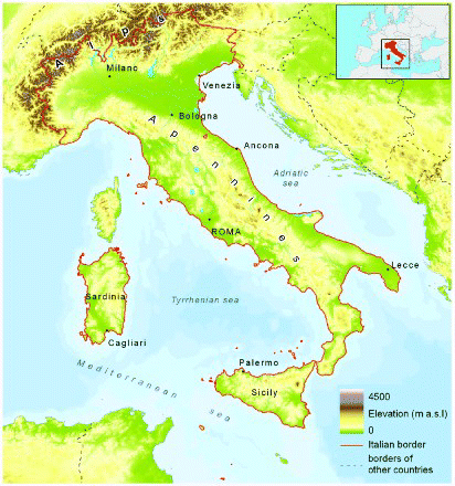
The Italian peninsula is characterized by high climatic variability and diversity, due to the geographic and orographic heterogeneity (). Indeed, Italy is situated at the centre of the Mediterranean basin, which is combined with a wide latitudinal extent that represents a long narrow bridge between the temperate and mediterranean macrobioclimates (CitationBiondi & Baldoni, 1994a). Also, the presence of complex orographic systems contributes to the high climatic diversity, such as the Alps in the north of Italy and the Apennines chain that extends the length of the Italian peninsula, and the proximity of the African and Eurasian continental masses.
Figure 1. Study area.
2.2. The worldwide bioclimatic classification system
The WBCS (CitationRivas-Martínez, 2004, Citation2008; CitationRivas-Martínez et al., 1999, Citation2011) allows diagnosis and bioclimatic classification of territories according to a hierarchical system that includes the following units: macrobioclimate, bioclimate, bioclimatic variant, thermotype and ombrotype. This classification is based on a set of climatic parameters and bioclimatic indices (as detailed in ), which are mainly based on temperature and precipitation data.
Table 1. Bioclimatic parameters and indices applied to the study area, according to CitationRivas-Martínez et al. (2011).
The macrobioclimate represents the higher-ranking typological unit that is divided into bioclimates and variants. Variations in terms of temperature and precipitation also allow the definition of thermotypes and ombrotypes. Indeed, the unique combination of bioclimates, bioclimatic variants, thermotypes, and ombrotypes identifies the isobioclimates.
The identification and mapping of these bioclimatic units, together with the calculation of climatic parameters and bioclimatic indices, were based on the hierarchy implied in the WBCS. The following describes the bioclimatic units and bioclimatic indices included in the final map (MainMap). All of the details of the WBCS can be found in CitationRivas-Martínez et al. (2011).
2.2.1. Macrobioclimates
As is known, both the temperate and mediterranean macrobioclimates are present in Italy. The mediterranean macrobioclimate is defined by at least two consecutive arid summer months, during which precipitation (mm) is less than or equal to double the temperature (in °C; p ≤ 2 T).
To identify the macrobioclimate boundaries, the following ombrothermic indices were taken into consideration: the annual ombrothermic index (Io), the ombrothermic index of the warmest bimonth of the summer (Ios2), the ombrothermic index of summer (Ios3), and the ombrothermic index of summer plus the previous month (Ios4). These last two indices in particular (Ios3, Ios4) are necessary for the classification and mapping of the areas of transition between the mediterranean and temperate macrobioclimates ().
Table 2. Compensation threshold values derived from CitationRivas-Martínez et al. (2011).
2.2.2. Bioclimatic variants
The bioclimatic variants represent typological units that can be recognized within macrobioclimates, which show the particular rainfall and thermic patterns, and which complement the descriptions of the bioclimates, particularly in transitional zones. Within the mediterranean macrobioclimate, the steppic variant is recognizable, while within the temperate macrobioclimate there are both the steppic and submediterranean variants. The steppic variant indicates that the simple continentality index (Ic) is >17, the summer precipitation (Ps) is higher than the winter precipitation (Pw) (i.e. Ps ≥ Pw), the ombrothermic index (Io) is between 6 and 0.2 (i.e. 6.0 > Io > 0.2), and finally, at least one month during the summer period is characterized by precipitation (Ps1; in mm) that is lower than three times the temperature (in °C) of the same month (i.e. Ios1 < 3).
The submediterranean variant is very common in the Italian temperate macrobioclimate, compared to the steppic variant, and it is characterized by the occurrence of at least one summer month with precipitation (in mm) <2.8 times the average temperature (in °C) of the same month (i.e. ). The submediterraneity index (Isbm) is useful to assess the degree of the submediterranean variant (). In the macrobioclimate map, we grouped (or simplified) the submediterraneity into two groups, as weak and strong submediterranean.
Table 3. Threshold values for the submediterraneity levels (CitationRivas-Martínez et al., 2011).
2.2.3. Continentality types
The continentality types were identified as the ranges () in the simple continentality index (Ic) gradient. This index expresses the annual width range of the temperature between the average temperatures of the warmest (Tmax) and coldest (Tmin) months of the year.
Table 4. Threshold values for the continentality types and subtypes, according to CitationRivas-Martínez et al. (2011).
2.2.4. Bioclimates
The bioclimates are identifiable by taking into consideration the macrobioclimate, the annual ombrothermic index (Io), and the simple continentality index (Ic) ().
Table 5. According to the macrobioclimate, the Io and Ic values identify the bioclimate, according to CitationRivas-Martínez et al. (2011).
2.2.5. Ombrotypes and thermotypes (bioclimatic belts)
The ombrotypes are classified as the ranges in the annual ombrothermic index (Io) gradient ().
Table 6. Threshold values for the ombrotype horizons, according to CitationRivas-Martínez et al. (2011).
The thermotypes () are identified by the ranges in the thermicity index (It), the compensated thermicity index (Itc), and the yearly positive temperature (Tp). The thermicity index evaluates the intensity of the cold as a limiting factor for the development of many plants and plant communities. The compensated thermicity index is calculated to compensate for the extra winter cold and the extra winter warmth of the highly continental territories and highly oceanic ones, respectively. So the resulting Itc values are comparable.
Table 7. The compensated thermicity index (Itc) and positive temperature (Tp) threshold values for the thermotypes, according to CitationRivas-Martínez et al. (2011). Tp is used if Ic ≥ 21 or It, Itc < 120.
The combination of the thermotypes with the ombrotypes identifies the bioclimatic belts.
2.2.6. Isobioclimates
The isobioclimates are the unique combination of the macrobioclimates, bioclimatic variants, bioclimates, thermotypes and ombrotypes. These represent a detailed bioclimatic model for an area with homogeneous climatic characteristics.
2.2.7. Other bioclimatic indices
The ombro-evapotranspiration index (Ioe) is also calculated as the quotient between the average annual precipitation (P; in mm) and the annual potential evapotranspiration index and it represents the reciprocal of the aridity index of the territories. This potential evapotranspiration assumes unlimited availability of moisture in the soil for the vegetation (CitationThornthwaite & Mather, 1957). The annual potential evapotranspiration index is then calculated (PE), as the sum of each monthly potential evapotranspiration (PEi).
2.3. Climatic data processing and mapping
We set the algorithms of the conditional instructions using the map algebra language in a geographic information system (Esri ArcGIS), to calculate all of the climatic parameters and bioclimatic indices, and for the mapping of all of the different bioclimatic units described above.
As source data, we used the WorldClim spatial climatic data (30 arc-seconds for about 1 km of resolution; CitationHijmans et al., 2005): the average monthly minimum temperatures (°C ×10), the average monthly mean temperatures (°C ×10), the average monthly maximum temperatures (°C ×10), the annual mean temperature range (°C ×10), and the average monthly and annual precipitation (mm).
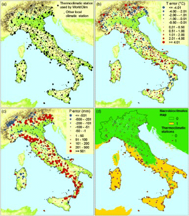
As far as Italy is concerned, the WorldClim data are mainly based on climate observations from 1950 to 2000 from 152 thermopluviometric stations () of the Global Historical Climate Network Dataset (GHCN) version 2 (CitationPeterson & Vose, 1997), the WMO climatological normals (CLINO) for 1961–1990 (WMO, Citation1996), and the FAOCLIM 2.0 global climate database (FAO, Citation2001).
Figure 2. (a) Map of the all of the observed meteorological data, (b) Map of the error of mean annual temperature, (c) Map of the error of mean annual precipitation, and (d) Macrobioclimates of the thermoclimatic stations overlaid on the macrobioclimate map (Macrobioclimates: 0, temperate; 1, mediterranean).
2.4. Map validation
The observed local meteorological data used for the map validation () consist of the 152 thermopluviometric stations considered by WorldClim and another 967 national and regional climatic stations (from 1950–1990) of the ‘Italian national system for the collection of climatological data of environmental interest’ (http://www.scia.sinanet.apat.it/home.asp – CitationDesiato, Fioravanti, Fraschetti, Perconti, & Toreti, 2011; http://clisun.casaccia.enea.it/Pagine/Index.htm – CitationPetrarca, Spinelli, Cogliani, & Mancini, 1999). Thus, a dataset of 1119 meteorological observations was obtained (351 thermopluviometric stations, 479 thermometric stations, and 289 pluviometric stations).
CitationHijmans et al. (2005) indicated some limitations of the WorldClim spatial dataset accuracy at regional and national scales, and in particular concerning precipitation in mountain areas. For this reason we evaluated how well the WorldClim dataset represents the observed meteorological data for temperature, precipitation and the bioclimatic indices of , using the mean absolute error (MAE), as given in Equation (1):
which is the average of the absolute errors (ei), where (ei) is the difference between the observed value of a climatic station (yi) and the value of the corresponding cell on a climatic raster dataset (). The mean annual temperature (T) and annual precipitation (P) errors (e
i) were mapped to assess the spatial patterns in the errors themselves. The sizes of the points in (b and c) are proportional to the values of the errors, and the colors indicate positive or negative errors.
Finally we assessed the degree of agreement between the WBCS map of Italy presented here (MainMap) and the WBCS applied to the observed meteorological data using Cohen's K statistic (CitationCohen, 1960) implemented in the ‘fmsb’ package (CitationNakazawa, 2013) within R (CitationR Core Team, 2012). Cohen's kappa (K) is a measure of the agreement between two sets of categorical data, whereby the agreement due to chance is factored out according to Equation (2):
where Pa is the proportion of observations in agreement, and Pe is the proportion in agreement due to chance. These K values have been interpreted as follows (CitationLandis & Koch, 1977): <0.2, slight agreement; 0.2–0.4, fair agreement; 0.4–0.6, moderate agreement; 0.6–0.8, substantial agreement; 0.8–1.0, almost perfect agreement.
3. Results
The procedures described above allowed us to produce the bioclimatic maps of Italy (MainMap). The application of the WBCS was composed of the following map insets:
macrobioclimate (1:5,500,000);
bioclimate (1:5,500,000);
continentality type (1:5,500,000);
ombrotype (1:5,500,000);
thermotype (1:2,250,000);
compensated thermicity index (Itc; 1:5,500,000);
ombro-evapotranspiration index (Ioe; 1:5,500,000);
bioclimatic synoptic table of Italy.
We then identified all of the different bioclimatic units (i.e. macrobioclimates, bioclimates, bioclimatic variants, thermotypes, ombrotypes and isobioclimates) for the Italian territory, mapping two macrobioclimates, as temperate and mediterranean. These cover 43.48% and 56.52%, respectively, of the Italian territory. We also recognized the submediterranean and steppic bioclimatic variants in the temperate macrobioclimate. We identified eight different bioclimates (taking into consideration the bioclimatic variants), six types of continentality, 11 ombrotype horizons, 18 thermotype horizons, and finally 93 isobioclimates. All of these bioclimatic units for the Italian territory are detailed in . The bioclimatic maps (MainMap) and indices listed above are also supplied in the Esri grid raster format in the supplementary materials.
Table 8. Bioclimatic synoptic table of Italy.
In , the results of the validation map process are reported. gives the MAEs for temperature and precipitation for each month. reports the MAEs for the bioclimatic indices listed in . shows the K values of each of the bioclimatic units mapped here.
Table 9. Mean absolute errors (MAEs) for the monthly temperature (Ti) and precipitation (Pi). (Months: 1 January to 12 December).
Table 10. Mean absolute errors (MAEs) for the bioclimatic indices listed in .
Table 11. Values of Cohen's K statistic (CitationCohen, 1960) for each of the bioclimatic units.
(b and c) show the map error of the mean annual precipitation (P) and the mean annual temperature (T), respectively. (d) shows the distribution of the macrobioclimates of the observed local meteorological data overlaid on the macrobioclimate map.
4. Conclusions
The present study has allowed the interpretation and mapping, as well as a summary, of the Italian bioclimatic characteristics according to the WBCS. The WBCS bioclimatic maps (MainMap) and raster dataset presented here represent the most exhaustive bioclimatic maps produced for Italy to date at the national scale sensu CitationRivas-Martínez (2004, Citation2008) and CitationRivas-Martínez et al. (2011). Indeed, all of the different types of WBCS bioclimatic units have been mapped.
The map validation procedures allowed in-depth exploration of the WorldClim spatial dataset, with the quantification and identification of major deviations between the observed local meteorological data and the data spatially predicted by WorldClim.
All of the average monthly temperatures (Ti) have a MAE between 0.8°C and 0.9°C, while the error distribution () does not show any clear spatial pattern, although in general, the largest errors are in the high mountains (Apennines and Alps). Despite the low density of the 152 thermopluviometric stations considered (), the temperature variation is relatively well explained by the WorldClim spatial data.
The situation is different for precipitation. The annual mean precipitation (P) error distributions () show strong spatial patterns. Positive errors are more prevalent than negative errors, and this outcome can be related to a general underestimation of precipitation by the WorldClim spatial dataset. These errors are principally distributed along mountain areas (Apennines and Alps) and locally they become relatively large. shows how the distribution of the highest positive errors is concentrated in the south and north of the Apennines and in the east of the Alps. Large negative errors (related to an overestimation of precipitation) are localized in the western Alps. These differences were not captured by WorldClim, because of the sparse density of meteorological stations, and they are probably due to locally important climate drivers, such as those caused by local barrier effects (CitationHijmans et al., 2005; CitationMetzger et al., 2013). Thus, the WorldClim precipitation datasets show greater uncertainty than temperatures at the Italian national level, and this also affects the bioclimatic indices. The average monthly precipitation (Pi) has a MAE between 9 mm in July and 27 mm in November (). In , the MAEs are larger for P, Pp and Io, which is based on Pp, while in general, the summer ombrothermic indices (Ios1, Ios2, Ios3 and Ios4) have lower MAEs.
Despite these limitations, the WorldClim dataset provided sufficient spatial detail to apply the WBCS. Indeed, all of the K values calculated for each bioclimatic map presented here (MainMap) show good agreement with the observed data (), which demonstrates a good degree of reliability for such bioclimatic maps. The highest K was calculated for the macrobioclimate map. There is substantial agreement for the other units, although the bioclimates, variants and thermotypes are hierarchically linked to the macrobioclimates, and therefore they ‘inherit’ the errors that result from the macrobioclimate misclassifications.
The ombrotype horizons are the bioclimatic units with the greatest uncertainty and the lowest K values. This uncertainty decreases if we do not consider the horizon level (). This depends on both the large errors that plague the Io ombrothermic index, as based on the Pp, and also as the ombrotype horizon ranges are defined exponentially (; CitationMesquita & Sousa, 2009). Indeed, low values correspond to small ranges, and high values to wide ranges (e.g. Lower arid: 0.4–0.7; Upper hyper-humid: 18.0–24.0), so even small errors for low values can produce large errors in the ombrotype horizons.
In conclusion, we can say that the final macrobioclimates, bioclimates, thermotypes, continentality types and compensated thermicity index maps are highly satisfactory, while although it is considered moderately satisfactory, the ombrotype map has the greatest uncertainty.
From visual comparison, the bioclimatic maps of Italy presented here (MainMap) are in good agreement with those published previously at the regional and national scales for Italy (CitationAttorre, Francesconi, Valenti, Collalti, & Bruno, 2008; CitationBiondi & Baldoni, 1994a, Citation1994b, 1995; CitationBlasi, 1994, Citation1996; CitationBlasi & Michetti, 2005; CitationBlasi et al., 1999, Citation2007; CitationBrullo, Scelsi, Siracusa, & Spampinato, 1996; CitationCasavecchia et al., 2007; CitationRivas-Martínez et al., 2004a, Citation2004b, Citation2011). Some of these previous studies focused in particular on the definition of the limits between the mediterranean and the temperate macrobioclimates. In the present study, the definition of macrobioclimates has the highest reliability in comparison to the local observed meteorological data (see ). It appears that the areas with some uncertainty in the definition of macrobioclimates are those of the southern Apennines, where there is greater underestimation of the actual annual rainfall (here the Temperate macrobioclimate is probably underestimated). Furthermore, in the present study, the significant presence of the transition (submediterranean bioclimatic variant) between the temperate and mediterranean macrobioclimates is quantified and assessed in terms of the levels of submediterraneity (Isbm). Indeed, the submediterranean variant occupies 24.6% of the Italian territory ().
Together with the isobioclimates identified, the bioclimatic maps show the high bioclimatic diversity of Italy. In the present study, 93 isobioclimates () were identified and have been detailed in quantitative terms, but not mapped, as they require a greater local scale of representation. Indeed, the isobioclimates represent a bioclimatic model that will be useful to produce the detailed maps (CitationRivas-Martínez et al., 2011).
The bioclimatic maps and raster dataset presented here represent good tools that will be useful to support the analysis of vegetation–environment relationships at the national scale. This is even more important if we consider the recent production of the National Italian Vegetation Database ‘VegItaly’ (CitationGigante et al., 2012; CitationLanducci et al., 2012), which provides a vegetation and flora dataset at the national scale. In addition these maps can contribute to landscape classification as proposed for the land unit of Italy (CitationSmiraglia et al., 2013) and in particular they allow species distribution modeling and habitat modeling to be performed (CitationAustin, 1999; CitationBaselga & Araújo, 2009; CitationFerrier & Guisan, 2006; CitationFranklin, 1995; CitationGuisan & Zimmermann, 2000), as the climate data are probably the most important abiotic factors for plant distribution.
Therefore, these maps are useful to build spatial predictive models for vegetation, and also for monitoring climate change. These maps can be reproduced under future conditions, to monitor and quantify climate changes and the distribution of vegetation trends from the perspective of the WBCS. Indeed, the application of the WBCS at national, regional and local scales provides a multi-scale framework for the analysis of the responses of biotic systems to climate change (CitationRivas-Martínez et al., 2011; CitationTorregrosa, Taylor, Flint, & Flint, 2013).
Software
The production of the maps and the calculation of parameters and bioclimatic indices () for the compilation of the algorithms of conditional statements (i.e. the map algebra) was performed using Esri ArcGIS 9.0.
Data
We provide the maps and the most important bioclimatic indices in the raster data (both continuous and discrete) covering the study area. They are in the latitude/longitude coordinate reference system datum WGS84. The raster resolution is 1 km as 30 arc-seconds. The readme.pdf file gives the code values for the classified raster.
Main Map: Bioclimatic Maps of Italy: Application of the Worldwide Bioclimatic Classification System
Download Zip (100 MB)References
- Attorre, F., Francesconi, F., Valenti, R., Collalti, A., & Bruno, F. (2008). Production of climatic and bioclimatic maps by Universal Kriging with external drift: Theory and examples for Italy. Forest@, 5(1), 8–19. doi:10.3832/efor0507-0050008 doi: 10.3832/efor0507-0050008
- Austin, M. P. (1999). The potential contribution of vegetation ecology to biodiversity research. Ecography, 22, 465–484. doi:10.1111/j.1600-0587.1999.tb01276.x doi: 10.1111/j.1600-0587.1999.tb01276.x
- Baselga, A., & Araújo, M. B. (2009). Individualistic vs community modelling of species distributions under climate change. Ecography, 32(1), 55–65. doi:10.1111/j.1600-0587.2009.05856.x doi: 10.1111/j.1600-0587.2009.05856.x
- Biondi, E., & Baldoni, M. (1993). A Bioclimatic characteristics of the Italian peninsula. In Effects of atmospheric pollulants on climate and vegetation (pp. 225–250). Gea Program, Roma.
- Biondi, E., & Baldoni, M. (1994a). The climate and vegetation of peninsular Italy. Colloques Phytosociologiques, 23, 675–721.
- Biondi, E., & Baldoni, M. (1994b). Sul Fitoclima Della Penisola Italiana. Giornale botanico italiano, 128(1), 461–461. doi:10.1080/11263509409437265 doi: 10.1080/11263509409437265
- Biondi, E., & Baldoni, M. (1995). A possible method for geographic delimitation of phytoclimatic types: With application to the phytoclimate of the Marche region of Italy. Documents Phytosociologiques, 15, 15–28.
- Blasi, C. (1994). Il fitoclima del Lazio. Fitosociologia, 27, 151–195.
- Blasi, C. (1996). II fitoclima d'Italia. Giornale botanico italiano, 130(1), 166–176. doi:10.1080/11263509609439523 doi: 10.1080/11263509609439523
- Blasi, C., Carranza, M. L., Filesi, L., Tilia, A., & Acosta, A. (1999). Relation between climate and vegetation along a mediterranean-temperate boundary in central Italy. Global Ecology and Biogeography, 8(1), 17–27. doi:10.1046/j.1365-2699.1999.00121.x doi: 10.1046/j.1365-2699.1999.00121.x
- Blasi, C., Chirici, G., Corona, P., Marchetti, M., Maselli, F., & Puletti, N. (2007). Spatialization of climatic data at the Italian national level by local regressive models. Forest@ – Rivista di Selvicoltura ed Ecologia Forestale, 4(2), 213–219. doi:10.3832/efor0453-0040213 doi: 10.3832/efor0453-0040213
- Blasi, C., & Michetti, L. (2005). Biodiversity and climate. In C. Blasi, L. Boitani, S. La Posta, F. Manes, & M. Marchetti (Eds.), Biodiversity in Italy. Contribution to the national biodiversity strategy (pp. 57–66). Roma: Palombi Editori.
- Brullo, S., Scelsi, F., Siracusa, G., & Spampinato, G. (1996). Caratteristiche bioclimatiche della Sicilia. Giornale botanico italiano, 130(1), 177–185. doi:10.1080/11263509609439524 doi: 10.1080/11263509609439524
- Casavecchia, S., Biondi, E., Catorci, A., Pesaresi, S., Cesaretti, S., & Vitanzi, A. (2007). La regionalizzazione biogeografica quale elemento per una migliore comprensione del valore degli habitat: Il caso della Regione Marche. Fitosociologia, 44(2 SUPPL. 1), 103–113.
- Cohen, J. (1960). A coefficient of agreement for nominal scales. Educational and Psychological Measurement, 20, 37–46. doi: 10.1177/001316446002000104
- Desiato, F., Fioravanti, G., Fraschetti, P., Perconti, W., & Toreti, A. (2011). Climate indicators for Italy: Calculation and dissemination. Advances in Science and Research, 6, 147–150. doi:10.5194/asr-6-147-2011 doi: 10.5194/asr-6-147-2011
- FAO. (2001). FAOCLIM 2.0 a world-wide agroclimatic database. Rome, Italy: Food and Agriculture Organization of the United Nations.
- Ferrier, S., & Guisan, A. (2006). Spatial modelling of biodiversity at the community level. Journal of Applied Ecology, 43(3), 393–404. doi:10.1111/j.1365-2664.2006.01149.x doi: 10.1111/j.1365-2664.2006.01149.x
- Franklin, J. (1995). Predictive vegetation mapping: Geographic modelling of biospatial patterns in relation to environmental gradients. Progress in Physical Geography, 19, 474–499. doi:10.1177/030913339501900403 doi: 10.1177/030913339501900403
- Gigante, D., Acosta, A. T. R., Agrillo, E., Attorre, F., Cambria, V. E., Casavecchia, S., … Venanzoni, R. (2012). VegItaly: Technical features, crucial issues and some solutions. Plant Sociology, 49(2), 71–79. doi:10.7338/pls2012492/05
- Guisan, A., & Zimmermann, N. E. (2000). Predictive habitat distribution models in ecology. Ecological Modelling, 135(2–3), 147–186. doi:10.1016/S0304-3800(00)00354-9 doi: 10.1016/S0304-3800(00)00354-9
- Hijmans, R. J., Cameron, S. E., Parra, J. L., Jones, P. G., & Jarvis, A. (2005). Very high resolution interpolated climate surfaces for global land areas. International Journal of Climatology, 25(15), 1965–1978. doi:10.1002/joc.1276 doi: 10.1002/joc.1276
- Landis, J. R., & Koch, G. G. (1977). The measurement of observer agreement for categorical data. Biometrics, 33, 159–174. doi: 10.2307/2529310
- Landucci, F., Acosta, A. T. R., Agrillo, E., Attorre, F., Biondi, E., Cambria, V. E., … Venanzoni, R. (2012). VegItaly: The Italian collaborative project for a national vegetation database. Plant Biosystems – An International Journal Dealing with all Aspects of Plant Biology, 146(4), 756–763. doi:10.1080/11263504.2012.740093 doi: 10.1080/11263504.2012.740093
- Mesquita, S., & Sousa, A. J. (2009). Bioclimatic mapping using geostatistical approaches: Application to mainland Portugal. International Journal of Climatology, 29(14), 2156–2170. doi:10.1002/joc.1837 doi: 10.1002/joc.1837
- Metzger, M. J., Bunce, R. G. H., Jongman, R. H. G., Sayre, R., Trabucco, A., & Zomer, R. (2013). A high-resolution bioclimate map of the world: A unifying framework for global biodiversity research and monitoring. (M. Sykes, Ed.) Global Ecology and Biogeography, 22(5), 630–638. doi:10.1111/geb.12022 doi: 10.1111/geb.12022
- Nakazawa, M. (2013). fmsb: Functions for medical statistics book with some demographic data. Retrieved from http://cran.r-project.org/package=fmsb
- Peterson, T. C., & Vose, R. S. (1997). An overview of the global historical climatology network temperature database. Bulletin of the American Meteorological Society, 18, 2837–2849. Retrieved from http://www.ncdc.noaa.gov/ghcnm/v2.php doi: 10.1175/1520-0477(1997)078<2837:AOOTGH>2.0.CO;2
- Petrarca, S., Spinelli, F., Cogliani, E., & Mancini, M. (1999). Profilo climatico dell'Italia. Volume 0 – Introduzione metodologica (p. 102). Rome, Italy: ENEA.
- R Core Team. (2012). R: A language and environment for statistical computing, R Foundation for Statistical Computing. Vienna, Austria. Retrieved from http://www.r-project.org/
- Rivas-Martínez, S. (2004). Global bioclimatics (Clasificación Bioclimática de la Tierra). Phytosociological Research Center. Retrieved December 16, 2013, from http://www.globalbioclimatics.org/book/bioc/global_bioclimatics_0.htm
- Rivas-Martínez, S. (2008). Global bioclimatics (Clasificación Bioclimática de la Tierra). Phytosociological Research Center. Retrieved December 16, 2013, from http://www.globalbioclimatics.org/book/bioc/global_bioclimatics-2008_00.htm
- Rivas-Martínez, S., Penas, A., & Diaz, T. E. (2004a). Bioclimatic map of Europe – Bioclimates. Cartographic Service, University of Leon. Retrieved December 16, 2013, from http://www.globalbioclimatics.org/form/bi_med.htm
- Rivas-Martínez, S., Penas, A., & Diaz, T. E. (2004b). Bioclimatic map of Europe – Thermotypes. Cartographic Service, University of Leon. Retrieved December 16, 2013, from http://www.globalbioclimatics.org/form/tb_med.htm
- Rivas-Martínez, S., Sáenz, S. R., & Penas, A. (2011). Worldwide bioclimatic classification system. Global Geobotany, 1, 1–634.
- Rivas-Martínez, S., Sánchez-Mata, D., & Costa, M. (1999). North American boreal and Western temperate forest vegetation: (Syntaxonomical synopsis of the potential natural plant communities of North America, II). Itinera geobotanica, 12, 5–316.
- Smiraglia, D., Capotorti, G., Guida, D., Mollo, B., Siervo, V., & Blasi, C. (2013). Land units map of Italy. Journal of Maps, 9(2), 239–244. doi:10.1080/17445647.2013.771290 doi: 10.1080/17445647.2013.771290
- Thornthwaite, C. W., & Mather, J. R. (1957). Instructions and tables for the computing potential evapotranspiration and the water balance. Publications in Climatology, X(3), 185–311.
- Torregrosa, A., Taylor, M. D., Flint, L. E., and Flint, A. L. (2013). Present, future, and novel bioclimates of the San Francisco, California region. PloS one, 8(3), e58450. doi:10.1371/journal.pone.0058450 doi: 10.1371/journal.pone.0058450
- WMO. (1996). Climatological normals (CLINO) for the period 1961–1990. World Meteorological Organization, Geneva, Switzerland.