
Abstract
Between 2004 and 2008 the city of Worcester, UK experienced a number of pluvial flood events. The causes of this kind of flooding are the topic of ongoing research. This paper describes a study that aimed to investigate the urban development of Worcester over time in relation to the location of recorded pluvial flood incidents. A novel rapid mapping method has been developed to derive urban development over five time periods between 1886 and 1995 from scanned Ordnance Survey historical maps. The technique compared well with manual digitisation results with k-hat values ranging from 0.67 to 0.87 for the land use maps created for different time periods. The technique performed least well for the oldest map series, due to misclassification of the abundant symbols and annotation. The method will be particularly beneficial for investigation of town/city development in time over large areas. The resulting map of urban development in Worcester (scale 1:20,000) shows that almost half of the recorded pluvial flood incidents occurred in areas developed between 1956 and 1975, which contradicts local belief that an outdated (Victorian) drainage system causes most of the problems. The quality of the post World War II developments is more likely to be a source for concern.
1. Introduction
Land use change from rural to urban is generally thought to increase flooding in a river catchment. The increases in impervious surfaces and drainage pathways that result from urban development have shown to increase the peak discharge, volume, and frequency of river floods (e.g. Hejazi & Markus, Citation2009; Kázmierczak & Cavan, 2011; Villarini, Smith, Baeck, Smith, & Sturdevant-Rees, Citation2013; Whitfield, Citation2012). Similar changes are also likely to increase occurrences of pluvial flooding within the urban developments. Pluvial floods result from rainfall generated overland flow before the runoff enters any water course, drainage system or sewer (Cobby et al., Citation2008). It is usually the result of intense, often convective, rainstorms. In the UK such convective storms form mostly in summer due to cooling and condensation of rising air that has been heated near the surface during the day.
Although general principles of the effects of urbanisation on flooding processes are well understood, the specific mechanisms causing pluvial flooding are less clear (e.g. Parker, Priest, & McCarthy, Citation2011; Spekkers, Kok, Clemens, & ten Veldhuis, Citation2013). Understanding of historic urban development in relation to this type of flooding could contribute to our understanding of these mechanisms. Detailed information of historic developments is however not generally available and usually requires manual digitisation of relevant classes (e.g. Skokanová et al., Citation2012), prohibiting more exhaustive assessments of historic land use change and its link to flood records.
In the UK a good record of historic maps is available, which contains information on land use for several different time periods. Recently most historic Ordnance Survey maps have been scanned and made available for (licensed) use. These documents are monochrome (1-bit) raster datasets. Although this means there are no distinct map elements or attribute data available for analysis, the maps at scale 1:10,000 and 1:10,560 consistently show detailed line work of mostly roads, property boundary and building outlines. The density of this line work is clearly less for rural compared to urban areas. This paper and the accompanying Main Map present a novel technique that uses this textural difference in the raster datasets to obtain binary maps of urban and rural land use for all available historic mapping periods. These individual map layers can be combined into a change map.
To illustrate the potential benefit of such change maps for flood risk assessment, the technique is applied to a case study of the effect of urban development on pluvial flood risk in the city of Worcester, UK.
2. Case study area
Between 2004 and 2008 the city of Worcester, UK experienced a number of pluvial flood events (see dates in ). Several potential causes for these occurrences of localised flooding were suggested during discussions on the issue by Worcester local authorities. They included:
Exceptional (‘tropical’) rainfall intensity.
Blocked drains preventing sufficient surface drainage.
Decreased surface permeability leading to higher surface runoff.
Outdated (Victorian) drainage system that cannot cope with water volumes.
Table 1. Dates, times and intensity information for pluvial flood events in Worcester, UK between 2004 and 2008.
Research by Visser (Citation2008) in the Worcester city area showed how reported occurrences of pluvial flooding coincided with lines of highest flow accumulation. Flow accumulation was calculated using an eight-direction (D8) flow model, following an approach presented in Jenson & Domingue (Citation1988) in combination with the UK Ordnance Survey (OS) 10 m DEM. Of all locations for which pluvial flooding had been reported, 40% were situated within 10 m of a line of highest flow accumulation. Apparently in these locations surface and subsurface drainage systems could not handle the unusually large amount of water.
Inability of sewer/drainage systems to cope with increasing amounts of heavy rainfall and surface runoff are often mentioned in the literature as a main cause of pluvial flooding. However, not all areas with high flow accumulation were affected in this case. Investigation of radar rainfall intensity maps suggested that rainfall distribution did not explain the spatial distribution of the flooded locations in more detail either, so other factors may have had a significant influence.
One factor which is expected to influence the distribution of pluvial flooding is the type and age of the developments in the affected areas. In the Worcester case Victorian developments were expected to experience more flooding due to a more inadequate drainage system. The case study presented in this paper aimed to investigate the urban development of Worcester over time in relation to the location of recorded pluvial flood incidents.
3. Methods
3.1. Introduction
The proposed method for urban development mapping builds on the basic assumption that on the monochrome (1 bit) scans of historic Ordnance Survey maps from Edina Historic Digimap Service, built-up areas will appear darker than non-built-up/rural areas, due to the denser line work. Digital assessment of this variation in line work provides a rapid method to map the presence of built-up space during different historic time periods (i.e. automated, without need for manual digitisation and therefore relatively fast). The method does not purport to provide a method to outline the exact historical urban boundaries of Worcester. This will require further statistical analysis of the areas identified as built-up based on desired definitions of urban versus rural space. The method does however provide suitable data to do such an analysis with.
Good progress is made to map built-up space from satellite imagery and aerial photographs using image segmentation techniques (e.g. Herold, Liu, & Clarke, Citation2003), however the spatial and temporal coverage of such imagery is generally limited compared to that of topographic map series. This is certainly the case for the UK, where full coverage of Ordnance Survey maps is available for various dates since 1886. Some progress has been made to obtain information from analogue historic map data. Meinel, Hecht, & Herold (Citation2009) manage for example to extract buildings from topographic maps. However they do this from relatively recent and coarse scale maps (1:25,000). Other approaches make use of colour maps (e.g. Leyk & Boesch., Citation2010) or extract specific features such as forest only (e.g. Leyk & Boesch, Citation2009). Information extraction on built-up space for large areas from more detailed scale maps over long-time periods has so far not been done.
3.2. Rapid delineation of built-up space
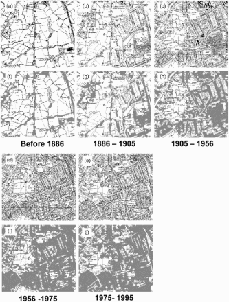
Using the steps outlined below, scanned OS maps of scale 1:10,560 or 1:10,000 from five dates between 1886 and 1995 were classified into binary maps delineating built-up (urban) and non-built-up (rural) space. (a–e) shows examples of detail in maps from all included time periods.
Figure 1. (a–j): Detail of historic OS maps for the Bournville area south of Birmingham and the results of automatic classification of built-up area in each example. Period built: before 1886 (a/f); 1886–1905 (b/g); 1905–1956 (c/h); 1956–1975 (d/i); 1975–1995 (e/j). Images provided by Ordnance Survey/EDINA service. © Crown Copyright/database right 2014.
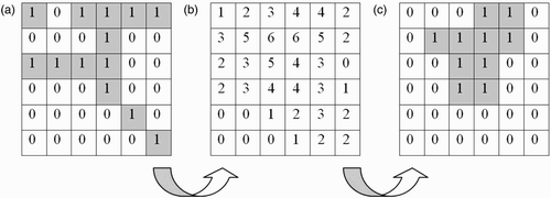
Tile scans were resampled to 1-m resolution and a neighbourhood operation was applied to each map, which ‘generalises’ the map information by summing black cells (value = 1) over a 30 × 30 m moving window. Areas with more than 200 black cells were classed as urban, areas with less black cells as rural. This generalisation procedure is further illustrated in .
Figure 2. Procedure for urban and rural land use ‘classification’ of a digitised monochrome historic OS map (a): Sum neighbouring cell values using a moving calculation window, e.g. 3 × 3 cells (b). Reclassify resulting layer into new binary map using appropriate threshold value to differentiate between built-up and non-built-up space, e.g. 4 (c).
The threshold number of 200 cells was estimated by calculating the total number of cells identified as urban in six sample areas (of up to 1 km2) with varying degrees of urban cover, using a range of thresholds, and comparing these with the number of cells obtained from a detailed manual urban outline digitisation (see ). The threshold was adjusted to 250 for the oldest map series.
Table 2. Number of cells representing built-up area as obtained using different threshold values for minimum no. built-up cells counted within the 30 × 30 m moving window. Values in bold are most similar to the no. of cells representing built-up areas obtained by manual digitisation.
To assess the accuracy of the procedure, the results of this rapid mapping method have been compared with the results from the more detailed manual urban outline digitisation of the six sample areas. The technique has also been applied to two other areas, with different urbanisation patterns: the rural village of Pershore and a part of the southern suburbs of Birmingham, including the model village of Bournville.
3.3. Urban development mapping
To visualise the urban development in Worcester over time the binary land use maps for all five mapping periods are stacked, after each raster data layer was converted to a vector polygon map and a number of generalisation steps were applied to enhance the map interpretation. The generalisation was done as follows: First the raster data is converted to polygons by grouping contiguous cells with the same values and creating vectors along the group boundaries. Next any polygons smaller than 1500 m2 are merged with those neighbouring polygons that have the longest shared border. Finally a smoothing algorithm is applied, which removes extraneous bends from the boundary vectors while preserving their essential shape (Wang, Citation1996). A reference bend baseline of 10 m was used as threshold here. The mapping process was repeated for the maps of Pershore and part of Birmingham.
The areal increase in urban land use over each mapped time period was quantified from the original raster data by subtracting each map from its subsequent version, resulting in a new map with values of 1 for newly developed sites and value of 0 for areas with no change.
3.4. Pluvial flood incident data
The distribution of urban development from 1886 onwards is combined with a dataset of pluvial flooding incidents that were reported in the city during four events between 2004 and 2008. This data consisted of addresses of households that have reported flood damage with local authorities (city and county council, police and fire brigade), during and after the four major rainfall events. The incident data is aggregated at postcode level to improve visualisation and ascertain confidentiality of the affected households.
No fluvial flooding occurred during any of the events. In all cases the stage of the River Severn, which passes through Worcester, was relatively low. Due to its size localised rainfall of short duration does not significantly contribute to river flow levels. River flooding in Worcester is generally the result of rainfall in the upper reaches of the catchment.
4. Results and discussion
4.1. Mapping results
shows the availability of historic OS maps for the Worcester City area. The five periods highlighted in bold have been used to map urban development over time. The 1938 series was excluded as it contains many, what appear to be, ‘proposed’ developments. The drawings of these developments do not show individual building and property boundaries, which prohibits classification as actual urban development. The 1980–1990 and 1990–1995 maps were combined into a single period to obtain complete spatial coverage.
Table 3. Map sheets available for Worcester, Pershore and south Birmingham from EDINA Historic Digimap Service. Series in bold have been used in this study.
The Main Map accompanying this article uses a sequential colour scheme to show the urban development of Worcester over the five different time periods from 1886. Despite initial generalisation all map layers still contain high numbers of relatively small polygons and many irregular boundaries. No further generalisation was performed, since an important purpose of the Main Map is showing the advantages and limitations of the presented method, which would become obscured.
Map 2 and 3 contain the development maps for two contrasting areas in the West Midlands region.
In all three cases a clear expansion of the urban development can be seen. Most of the development took place between 1956 and 1975. Also developments during the newest period from 1975 to 1995 are clearly present at the outskirts of the urban spaces in all three maps. A clear difference is however visible in the Birmingham map which shows distinct developments on its southern edge over the 1886 to 1905 period. This area of development represents the Bournville model village, an experiment in workers' housing by Cadbury Brothers, who owned Cadbury's chocolate factory, which started round 1895 (Whitehand & Carr, Citation2001). Also visible in this map is the infill of suburban green spaces as observed in urban development studies (e.g. Whitehand & Carr, Citation2001) see (d and e).
The surface areas built up during each development period are listed in .
Table 4. Urban surface area in ha as obtained from the individual land use layers and the combined dataset.
4.2. Implications for pluvial flooding in Worcester
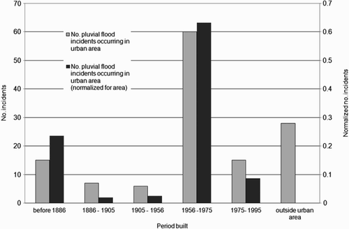
Reported pluvial flood incidences between 2004 and 2008 are shown in blue dots on the Worcester urban development map. The dot surface area is proportional to the number of flood incidents. The Main Map suggests that most incidents occurred in areas that were newly developed after the Second World War from the late 1950s to early 1970s. The actual numbers are 60 out of 131 recorded incidences. Although the total area of development was relatively large over this time period, normalisation of the data for the size of the development, shows that the number of incidents in this area is still more than twice as high as for any other period. The second most affected development is land built-up before 1886. The data for all development categories are presented in .
Figure 3. Number of pluvial flooding incidents occurring on built-up land for each classified period: Actual numbers (grey) and numbers normalised for area of each period (black).
Contrary to expectations the map results suggest that the ‘Victorian drainage system’ is not likely to be an important cause of the recorded flood incidents. In the parts of the city closest to the River Severn, where most Victorian properties are situated, relatively few pluvial flooding incidents have been recorded. No investigation or modelling was performed to identify to what extent the older, potentially overloaded drainage network in the low lying parts of the city may cause surcharge upstream in the system. However, if there was a direct link more problems might also be expected at the downstream end of the system.
The findings therefore point towards issues in the parts of the catchments where the actual problems are occurring. In addition to impeded drainage, impervious surfaces or buildings density are potential flood enhancing factors. There may well be a direct link between such additional factors and the timing of the development construction. During post the World War II period large building programmes for residential housing took place (Cullingworth & Nadin, Citation2006). In Worcester and elsewhere in the UK these developments are often seen to be of less desirable quality (Son & Kearns, Citation1998). Low quality of construction, including drainage facilities and potential disregard for existing hydrological conditions, in combination with a relatively densely built-up surface, may have led to the current situation.
With a likely increase in frequency of extreme rainfall due to climate change, it is important to understand the impact of land use planning. Understanding of the occurrence of flooding in relation to the age and quality of urban developments is particularly important in the light of an increasing body of research showing that areas most at risk of flooding tend to coincide with higher levels of deprivation in communities, which will be particularly hard hit by the impacts of flooding. (Kázmierczak & Cavan, 2011).
4.3. Accuracy assessment
For accuracy assessment of the rapid mapping method, six sample areas were manually digitised. Each consisted of approximately 727 × 727 cells (of 1 m2) out of a total mapping area of 7563 × 7944 cells. Their location was chosen so that they covered a range of built-up area percentages. Similarity between the manual and automated results was quantified by calculating the overall accuracy percentage and the kappa-hat statistic for the combined six areas (). shows a scatter diagram of areas estimated for each of the samples with the proposed rapid method against areas obtained through manual digitisation of the urban boundaries for each mapping date. These results indicate that the method is most suitable for the 1905–1956 and 1956–1975 map series, while the ‘before 1886’ and ‘1975–1995’ maps are least reliable. In general the rapid method seems to overestimate the urban space slightly for the least built-up areas. This is probably due to misclassification of larger roads and label text. Only for the nineteenth-century maps the rapid method consistently overestimates the size of urban space. This was expected, as the maps have a lot of additional text and symbols (e.g. forest) compared to the newer maps, which are easily miss-classified as urban space.
Figure 4. Scatter diagram of areas estimated with the proposed rapid method against areas obtained through manual digitisation of the urban boundaries for each mapping date. For the ‘before 1886’ period symbols in black show the results for the 200 cell threshold and symbols in grey those for the 250 cell threshold.
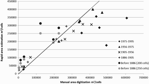
Table 5. Kappa Hat coefficient and overall accuracy of a confusion matrix of the automatically estimated vs. the manually determined surface area of the 6 sample locations (app. 727 × 727 cells each).
For more built-up areas in the newer map series the rapid method mostly underestimates the urban space. To a large extent this is due to large gardens and open spaces between housing blocks being misclassified as rural with the automatic approach, while they have been incorporated in the urban space during manual digitisation as can be seen in (g–j). One way to overcome this problem is by decreasing the minimum pixel number which defines urban space; however this would cause misclassification of non-urban space elsewhere. Similar decisions on where to draw the boundary between built-up and rural space have to be made during manual digitisation and will depend on the final purpose of the map. The automated process does not incorporate context in the classification process as done during manual digitisation. Although this may in some way make the process less accurate, it will in any case ensure that the classification process is unbiased, which could be a beneficial aspect for some applications.
4.4. Threshold estimation
To determine the most suitable threshold number of cells that represent built-up space, built-up area obtained for different threshold levels was compared with built-up area obtained by manual digitisation, as presented in . The results show that there is considerable variation between map series. The newest map series shows most similar cover values for a threshold between 100 and 125 cells, while for the oldest series the best threshold seems to be between 300 and 325 cells. This led to the initial decision to use 200 cells for all map series.
To some extent the variation in optimal threshold numbers is to be expected as the newer map series consist of increasingly thinner lines and much less elaborate symbology compared to the older maps. It could be questioned whether it would be more appropriate to use a different threshold for each mapping series based on the presented threshold assessment. However, part of the difference between built-up area estimates will be due to way the manual digitising was performed for each mapping period and the decisions made during this process, as discussed in the previous section. The automated urban classification will include underestimation in certain areas (e.g. gardens) and overestimation in others (e.g. areas with dense annotation), which makes it impossible to determine an exact threshold.
An alternative approach could be to set threshold levels ranges, which could pick out changes in suburban building density as a result of suburban infilling (Whitehand & Carr, Citation2001). Such information would be highly beneficial for flood risk modelling and assessment (White, Citation2010).
4.5. Further comments on the classification approach
Especially the ‘County Series’ maps (until 1970s) contains annotation in large fonts, which stand out clearly in most maps as wrongly classified urban space. This problem is less in the newer maps. More elaborate symbols used in the older map series for some landscape features such as forests are also misclassified. Orchards however, which cover large areas surrounding Pershore, were correctly classified as rural. The largest clearly misclassified annotation polygons have been manually removed from the Worcester map, but are still included in the two other maps. (a–j) show a close up of both the original map and the classification results for each time period for the Bournville area.
Manually editing the maps to improve results would be a relatively time consuming and potentially not essential for larger-scale mapping efforts. Improvements of mapping speed and accuracy may in the future be achieved by adopting optical character recognition (OCR) techniques, to identify and remove text from the maps before change analysis. Development of such techniques is ongoing, but still in an early stage (e.g. Meinel et al., Citation2009; Mello, Costa, & dos Santos, Citation2012).
A comparison of the total areas determined with the land use classification for each time period, with the cumulative area increase obtained by summing the built-up area expansion for each time interval, shows large discrepancies (). This difference is mostly due to the fact that especially the land use maps for the more recent periods contain more open spaces in the urban development line work. This will result in under estimation of the total built-up area compared to the area estimated from older maps (assuming no significant demolition took place). The total area recorded for the 1886–1905 period is actually smaller than that recorded for the mapping period up to 1886. This is mostly due to the fact that there was very little expansion of the city during the former period while the classification of the older map period suffers from considerable over estimation of urban space due to the dense symbology used in this map series.
4.6. From built-up space to historic urban boundaries
In section 3.1 it was stated that the proposed method only allows outlining built-up space. To obtain actual historic urban boundaries from this data further statistical analysis will need to be performed. The kind of analysis this involves will depend on the ultimate purpose of the analysis and the views of the researchers involved. The morphological delineation of urban agglomerations, is a matter of ongoing debate, which is beyond the scope of this paper. One example of analysis that could be done is the method used to delineate urban areas in CORINE Land Cover project. This considers settlements separated by a distance of more than 200 m to be distinct spatial entities (Weber, Citation2001). Other possible approaches are the use of spatial metrics (e.g. Herold et al., Citation2003) or fractals (e.g. Tannier et al., Citation2011). The method presented in this paper could even be used to contribute to this debate as it can provide a rather unbiased delineation of built-up area, which can highlight differences in urban morphology over time and space. Similar outcomes are more difficult to obtain from satellite imagery and aerial photographs, where interpretation can be strongly affected by variation in lighting conditions between collection dates.
5. Conclusion
In the research project described in this paper a method was developed to allow rapid mapping of urban development in the city of Worcester from historic Ordnance Survey maps. Comparison of the resulting maps of land use change between 1886 and 1995 with occurrences of pluvial flood incidents, recorded between 2004 and 2008, showed how in particular developments built in the 1960s and early 1970s were affected by this kind of flooding. These findings contradict the locally made assumption that an outdated drainage system in Victorian developments is an important cause of the flooding. Inadequate drainage provision and morphology of the affected more recent developments seem to be a more likely cause.
The presented technique to map urban development from historical maps looks promising for investigations of town/city developments in time over larger areas in the UK and potentially other countries with a digitised archive of historic maps. The urbanisation records can be used to increase our understanding of the relationship between urban development and changes in flood magnitude and frequency. Possible applications for such maps stretch well beyond the given example of pluvial flood risk in Worcester. The method has the advantage that it allows mapping of historic time periods before those covered by aerial photography and satellite images, which can be interpreted with conventional image analysis techniques. Also, large areas can be covered, which would not be feasible through manual digitisation.
Software
Analysis of historic Ordnance Survey data and creation of the Main Map were all done in ESRI ArcGIS 10.1 for Desktop with ‘Advanced’ Licence Type.
Main Map: Rapid Mapping of Urban Development from Historic Ordnance Survey Maps: An Application for Pluvial Flood Risk in Worcester
Download PDF (6.7 MB)Acknowledgments
The author of this manuscript would like to thank Worcester City Council for providing the pluvial flooding incidence data for this project.
Related Research Data
References
- Cobby, D., Falconer, R., Forbes, G., Smyth, P., Widgery, N., Astle, G., … Golding, B. (2008). Potential warning services for groundwater and pluvial flooding. In S. Huntington, P. Samuels, W. Allsop, & J. Harrop (Eds.), Flood risk management: Research and practice (pp. 1273–1280). London: CRC Press. doi: 10.1201/9780203883020.ch150.
- Cullingworth, J. B., & Nadin, V. (2006). Town and country planning in the UK. London: Routledge. ISBN: 0415358094.
- Hejazi, M., & Markus, M. (2009). Impacts of urbanization and climate variability on floods in northeastern Illinois. Journal of Hydrologic Engineering, 14(6), 606–616. doi: 10.1061/(ASCE)HE.1943-5584.0000020. doi: 10.1061/(ASCE)HE.1943-5584.0000020
- Herold, M., Liu, X., & Clarke, K. C. (2003). Spatial metrics and image texture for mapping urban land use. Photogrammetric Engineering and Remote Sensing, 69(9), 991–1002. doi: 10.14358/PERS.69.9.991
- Jenson, S. K., & Domingue, J. O. (1988). Extracting topographic structure from digital elevation data for geographic information system analysis. Photogrammetric Engineering and Remote Sensing, 54(11), 1593–1600.
- Kaźmierczak, A., & Cavan, G. (2011). Surface water flooding risk to urban communities: Analysis of vulnerability, hazard and exposure. Landscape and Urban Planning, 103(2), 185–197. doi: 10.1016/j.landurbplan.2011.07.008. doi: 10.1016/j.landurbplan.2011.07.008
- Leyk, S., & Boesch, R. (2009). Extracting composite cartographic area features in low-quality maps. Cartography and Geographic Information Science, 36(1), 71–79. doi: 10.1559/152304009787340115. doi: 10.1559/152304009787340115
- Leyk, S., & Boesch, R. (2010). Colors of the past: Color image segmentation in historical topographic maps based on homogeneity. GeoInformatica, 14(1), 1–21. doi: 10.1007/s10707–008-0074-z. doi: 10.1007/s10707-008-0074-z
- Meinel, G., Hecht, R., & Herold, H. (2009). Analyzing building stock using topographic maps and GIS. Building Research & Information, 37(5–6), 468–482. doi: 10.1080/09613210903159833. doi: 10.1080/09613210903159833
- Mello, C. A. B., Costa, D. C., & dos Santos, T. J. (2012). Automatic image segmentation of old topographic maps and floor plans. Systems, Man, and Cybernetics (SMC), Seoul 2012, IEEE International Conference on, pp. 132–137.
- Parker, D. J., Priest, S. J., & McCarthy, S. S. (2011). Surface water flood warnings requirements and potential in England and Wales. Applied Geography, 31(3), 891–900. doi: 10.1016/j.apgeog.2011.01.002. doi: 10.1016/j.apgeog.2011.01.002
- Skokanová, H., Havlíčeka, M., Boroveca, R., Demeka, J., Eremiášováa, R., Chrudinaa, Z., … Svobodaa, J. (2012). Development of land use and main land use change processes in the period 1836–2006: Case study in the Czech Republic. Journal of Maps, 8(1), 88–96. doi: 10.1080/17445647.2012.668768. doi: 10.1080/17445647.2012.668768
- Son, H. P., & Kearns, A. (1998). Difficult to let housing association stock in England: Property, management and context. Housing Studies, 13(3), 391–414. doi: 10.1080/02673039883344. doi: 10.1080/02673039883344
- Spekkers, M. H., Kok, M., Clemens, F. H. L. R., & ten Veldhuis, J. A. E. (2013). A statistical analysis of insurance damage claims related to rainfall Extremes. Hydrology and Earth Systems Science, 17, 913–922. doi:10.5194/hess-17–913–2013. doi: 10.5194/hess-17-913-2013
- Tannier, C., Thomas, I., Vuidel, G., & Frankhauser, P. (2011). A fractal approach to identifying urban boundaries. Geographical Analysis, 43, 211–227. ISSN 0016-7363. doi: 10.1111/j.1538-4632.2011.00814.x
- Villarini, G., Smith, J., Baeck, M., Smith, B., & Sturdevant-Rees, P. (2013). Hydrologic analyses of the july 17–18, 1996, Flood in Chicago and the role of urbanization. Journal of Hydrologic Engineering, 18(2), 250–259. doi: 10.1061/(ASCE)HE.1943-5584.0000462. doi: 10.1061/(ASCE)HE.1943-5584.0000462
- Visser, F. (2008). The day roads became rivers: A GIS-based assessment of flash floods in Worcester. In S. Huntington, P. Samuels, W. Allsop, & J. Harrop (Eds.), Flood risk management: Research and practice (pp. 1617–1621). London: CRC Press. ISBN 978-0-415-48507-4.
- Wang, Z. (1996). Manual versus automated line generalization. GIS/LIS '96 Proceedings, pp. 94–106.
- Weber, C. (2001). Urban agglomeration delimitation using remote sensing data. In J. Donnay, M. J. Barnsley, & P. A. Longley (Eds.), Remote sensing and urban analysis. GISDATA 9 (pp. 131–145). London: CRC Press. ISBN 0–203–34208–9.
- White, I. (2010). Water and the city: Risk, resilience and planning for a sustainable future. Abingdon: Routledge. ISBN-10: 0415553334.
- Whitehand, J. W. R., & Carr, C. M. H. (2001). Twentieth-century suburbs: A morphological approach. London: Routledge 2001. ISBN: 0415257700, 9780415257701.
- Whitfield, P. H. (2012). Floods in future climates: A review. Journal of Flood Risk Management, 5(4), 336–365. doi: 10.1111/j.1753-318X.2012.01150.x. doi: 10.1111/j.1753-318X.2012.01150.x