
Abstract
We present the first detailed map of the terrestrial natural radioactivity of the Veneto Region (Italy), a 18,264 km2 densely populated area, previously investigated through indoor radon surveys. The activity concentration in 709 representative samples of the main Alpine lithostratigraphic units was measured by using a high-purity germanium (HPGe) γ-ray spectrometer to characterize the radioactivity content of the 41 cartographic units of the Veneto Lithostratigraphic map at 1:250,000 scale. An area accounting for 61% of the territory, comprising alluvial plains was investigated through airborne γ-ray measurements. The large-volume NaI detectors were mounted on an ultralight aircraft, flying a 7000 km line. The data were interpolated using Ordinary Kriging, and a distribution model of the radioactivity content was produced. The result of the data analysis is a total natural radioactivity map of Veneto at 1:250,000 scale in which the activity concentration of the territory is visualized in seven classes, according to the percentile values calculated on the total dataset of measurements.
1. Introduction
Following the International Atomic Energy Agency (IAEA) recommendation for the development of radioelement baseline maps (CitationIAEA, 2010), here we present the total radioactivity map of the Veneto Region (Italy), based on γ-ray spectroscopy measurements. A map of the natural radioactivity content is a basic component for supporting research in physics, Earth and life sciences. Many research projects have focused on the absorbed dose distribution due to the natural background radiation (CitationGrasty, 2004) or on mapping geogenic radon considering the distribution of geological units (CitationKemski, Siehl, Stegemann, & Valdivia-Manchego, 2001). Although different research teams in the Veneto Region have studied indoor exposure to natural radioactivity (CitationTrotti et al., 1994) and mapped the areas with elevated indoor radon levels (CitationTrotti et al., 1998), a map of the activity concentration is still a missing piece of knowledge in a region with one of the highest population densities in Europe.
The mountainous areas were investigated based upon the geological map with reconnaissance of lithostratigraphical units at a scale of 1:250,000: a sampling strategy was planned to characterize the 41 Cartographic Units (CU) on the basis of the radiometric responses of 709 representative rock samples. In the Quaternary plain deposits, the distribution of activity concentration was obtained by geostatistical interpolation of airborne γ-ray measurements, interpolated using Ordinary Kriging. We produced the map of total natural radioactivity of the Veneto Region using statistical techniques for combining all the data into a single, coherent, cartographic reference frame.
2. Geological setting
The mountainous areas of Veneto are characterized, from the geological perspective, of rocks deformed during the Alpine orogeny, a mountain-building event that affected a broad segment of Southern Europe and the Mediterranean region during the Paleogene and Neogene periods (65.5 to 2.6 millions of years ago).
The Alpine orogeny has been linked with the Cretaceous-Tertiary convergence that led to the disappearance of the Piemont-Liguria Ocean and to the subduction of the European plate beneath the African plate (Miocene). The Alps belong to the Alps-Himalaya orogenetic system, composed of relatively young mountains (Cretaceous-Paleogene) having a crustal structure characterized by opposite vergence. Two main tectonic systems are distinguishable: the European chain, with a W-NW vergence, and the Southern Alps, with a S-SE vergence.
The stratigraphic succession of the Veneto Region, included within the Subalpine Domain, is formed by a Paleozoic crystalline basement and by sequences of sedimentary and volcanic covers (from Permian to Quaternary) ().
Figure 1. Schematic lithostratigraphic map of the Veneto Region.
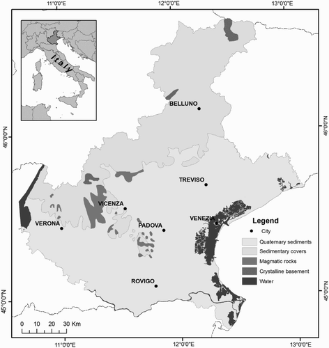
The crystalline basement, made up of metamorphic rocks (metasandstones, metabasalts, phyllites, metarhyolites), is the product of the recrystallization and deformation of sedimentary and volcanic rocks. The basement outcrops are confined in the Recoaro (western sector of Veneto Region), Comelico and Agordo (northern sector) areas.
The extended sedimentary cover (see ) is characterized by the presence of Paleozoic rocks (volcanic, sandstone, limestones and marls), Mesozoic rocks (mainly dolomites, limestone and marls) and Tertiary sequences (sandstones and conglomerates) in flysch and molasses facies.
The volcanic rocks, mainly outcropping in the Recoaro area and Euganean Hills, represent the evidence of two different magmatic cycles. The first cycle (Triassic, Recoaro area) refers to early products of rhyolitic, rhyodacitic and dacitic composition, followed by rhyolitic-dacitic flows and products of andesitic and basaltic composition. The second cycle (Paleogene, Euganean Hills) is related to an intense effusive activity, characterized by the presence of basalt lava flows, hyaloclastite, breccias and volcanic dikes.
The Subalpine Domain is covered by Quaternary sediments formed by erosion and transport processes. These sediments include moraine deposits and sequences of alluvional materials made up of fluvial, lake and marsh deposits.
3. Methods
3.1. Reference geological map and sampling strategy
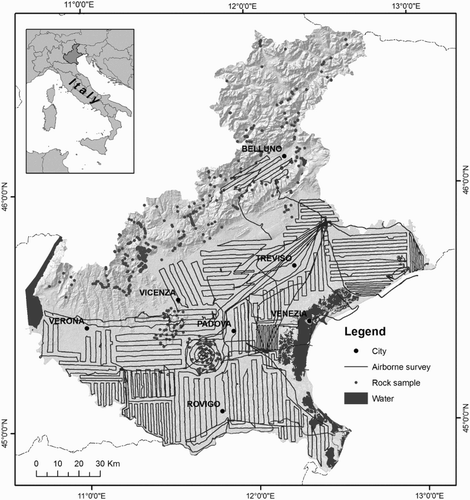
The geological map of Veneto at 1:250,000 scale (CitationAntonelli et al., 1990) was used as a guide for the natural radioactivity survey. The Veneto Region (18,264 km²) is classified into the Southern Alpine sector and Hill areas (SAH), covering approximately 39% of the territory, and into a wide River Plain area (RP) for the remaining 61% of the territory, formed of Quaternary alluvial deposits of the Po, Adige, Brenta, Piave and Tagliamento rivers. The 41 CU in the SAH areas were investigated by collecting 709 rock samples, following the sampling strategy described in (CitationCallegari et al., 2013), and obtaining an overall average of one data point per 25 km2. In particular, outcrops representative of each CU were explored collecting fresh rock samples. The Quaternary deposits of the RP areas were investigated using airborne γ-ray spectrometry (AGRS) measurements (CitationGuastaldi et al., 2013) performed during approximately 75 h of effective flight, which correspond to a 7000 km line. shows the locations of the collected rock samples and the effective flight lines performed during the AGRS survey.
Figure 2. The locations of the collected rock samples and the effective flight lines: the maximum line spacing is approximately 2.5 km.
3.2. HPGe laboratory measurements and data analysis
The activity concentrations of 40K, eU (equivalent uranium) and eTh (equivalent thorium) in 709 representative rock samples was measured using a fully automated HPGe γ-ray spectrometer, called the MCA_Rad (CitationXhixha et al., 2013). The MCA_Rad is composed of two 60% relative efficiency coaxial HPGe p-type detectors, having an energy resolution of approximately 1.9 keV at 1332.5 keV (60Co). The efficiency was calibrated using standard point sources with an overall uncertainty of less than 5%. Prior to measurement, each rock sample was crushed, homogenized and sealed in a cylindrical polycarbonate container with a volume of 180 cm3.
The activity concentrations of 40K, eU, eTh of the 41 CU were measured using 709 rock samples. The dataset is composed of a relevant fraction of the Minimum Detectable Activity (MDA) values, corresponding approximately to 9.4 Bq/kg for 40K, 2.5 Bq/kg for eU and 3.7 Bq/kg for eTh, mainly found in the carbonate rocks. The distribution function for each dataset was graphically studied using univariate statistics by means of both frequency histograms and percentage-probability P-P plots to gain an insight into the data structure. The Kolmogorov-Smirnov statistical test was applied to discriminate the normal and lognormal distributions, providing a p-value (usually p < 0.05) for rejecting the null hypothesis. The MDA values were treated on the basis of the statistical arguments described in (CitationHelsel, 1990). We verified that the distributions of 40K, eU and eTh are generally well fitted by a lognormal function. The total activity was calculated for each CU and the uncertainty propagation was evaluated using a Monte-Carlo method (CitationBIPM et al., 2008).
3.3. Airborne γ-ray data and data analysis
The AGRS measurements were performed using a modular instrument called the AGRS_16.0 L, composed of four NaI(Tl) detectors (10 cm × 10 cm × 40 cm each) with a total volume of approximately 16 Liters mounted on an autogyro (CitationGuastaldi et al., 2013). The system is further equipped with an ‘upward-looking’ NaI(Tl) detector of 1 L, partially shielded from ground radiation and used to account for an atmospheric radon correction. The position of the AGRS_16.0 L system was recorded using a global positioning system (GPS) receiver, and the height above the ground was calculated by applying the Laplace formula, using pressure and temperature values measured by dedicated sensors.
The radiometric data acquired during the AGRS survey was analyzed by first integrating the measured events in 12s interval γ-spectra. The γ-spectra are then calibrated and analyzed using the Full Spectrum Analysis with Non-Negative Least Squares constraints (FSA-NNLS) as described in (CitationCaciolli et al., 2012). The activity concentrations of 40K, eU and eTh at ground level were determined by applying several corrections to the measured signals, as described in (CitationGuastaldi et al., 2013): cosmic background corrections, topography corrections, variation in flying altitude and height corrections and atmospheric radon corrections. Finally, approximately 19×103 radiometric data for the 40K, eU and eTh concentrations were obtained and used to calculate the total activity concentration.
3.4. Mapping radiometric data
The frequency distribution of the total activity concentration of the overall geo-dataset obtained by laboratory and airborne γ-ray measurements are shown in . The map of the total activity concentration is obtained by interpolating the radioactivity content measured in representative samples of the 41 CU in the SAH areas and in the airborne γ-ray surveys in the RP area. In particular, the median value of the total activity concentration for each CU is assigned to the corresponding polygons in the SAH areas (CitationCallegari et al., 2013). For each radionuclide (40K, eU and eTh) in the RP areas, omnidirectional Experimental Semi-Variograms (ESV) composed by 12 lags of 1 km were computed and modeled. To check the goodness of the ESV models, a cross validation procedure was used. The interpolation of the activity concentrations of 40K, eU and eTh were rasterized in a 200 m × 200 m grid and used to calculate the total activity concentration.
Figure 3. The frequency distributions of the total activity concentration in rock samples (blue) and airborne γ-ray data measurements (red). The samples on the left of the dashed line are characterized by at least one concentration of K, U and Th below the MDA.
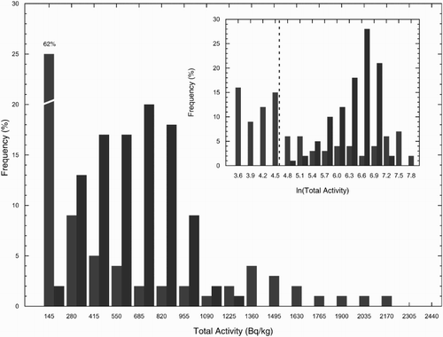
The legend of the Main Map was constructed following the recommendations of (CitationReimann, 2005). The total activity concentrations were grouped into seven classes of percentiles, calculated on the total dataset of 19,735 records. In particular, the intervals of the classes were appropriately identified as the 5th, 20th, 50th, 80th, 95th and 100th percentiles.
4. Conclusions
We present the first detailed investigation of the terrestrial natural radioactivity of the Veneto Region (Italy), obtained using γ-ray spectroscopy measurements. In particular the activity concentrations of SAH areas refer to rock reservoirs, while the radiometric data collected by AGRS surveys come from the top soil of RP areas.
Following the lithostratigraphic map at 1:250,000 scale (CitationAntonelli et al., 1990), the 41 CU of the SAH areas were characterized with respect to the total activity concentration by means of 709 measurements on rock samples performed using a HPGe γ-ray spectrometer. Over 50% of the SAH areas primarily consists of limestones and dolomites, characterized by a low total activity, often resulting in MDA values. The highest values of total activity in the SAH areas are found in the magmatic rocks of the Euganean Hills and the Recoaro area, together with the crystalline basement.
The Quaternary sediments of the RP area were investigated by means of airborne γ-ray surveys, accounting for 75 h of effective time of flight. The extended area with medium-high values of total activity concentration could be related to anthropogenic activities (CitationWetterlind et al., 2012) and selective fluvial deposition of the main river basins. In particular, we observed that the S-E area surrounding the Euganean Hills is characterized by enrichment in the radionuclides, probably due to the erosion and transport processes undergone by magmatic rocks.
Software
The geostatistical analysis was performed using Geovariances ISATIS®. The map was produced using ESRI ArcGIS 9.3.
Main Map: Total Natural Radioactivity Map of Veneto (Italy)
Download PDF (5 MB)Acknowledgments
The authors thank the cartographic support of the Veneto Region – directorate of regional geology and mining activities. The authors are grateful to Antongiovanni M., Pagotto C., Shyti M. and Bortolami A. We wish to thank Joachim Kemski, Chris Orton and Mirko Reguzzoni for their detailed and thoughtful reviews.
Funding
This work is partly supported by the Fondazione Cassa di Risparmio di Padova e Rovigo, the Istituto Nazionale di Fisica Nucleare (INFN), the Centre for GeoTechnologies (University of Siena) and by the MIUR (ITALRAD Project).
Related Research Data
References
- Antonelli, R., Barbieri, G., Dal Piaz, G. V., Pra, A. D., Zanche, V. D., Grandesso, P., … Zanferrari, A. (1990) Carta geologica del Veneto Scala 1:250000: una storia di cinquecento milioni di anni [Geological map of Veneto at scale 1:250000]. Regione del Veneto Giunta Regionale Segreteria Regionale per il territorio.
- BIPM, IEC, IFCC, ISO, IUPAC, IUPAP, & OIML. (2008). Evaluation of Measurement Data—Supplement 1 to the ‘Guide to the Expression of Uncertainty in Measurement’—Propagation of Distributions Using a Monte Carlo Method. Bureau International des Poids et Mesures(JCGM 101).
- Caciolli, A., Baldoncini, M., Bezzon, G. P., Broggini, C., Buso, G. P., Callegari, I., … Xhixha, G. (2012). A new FSA approach for in situ γ ray spectroscopy. Science of The Total Environment, 414(0), 639–645. doi:http://dx.doi.org/10.1016/j.scitotenv.2011.10.071 doi: 10.1016/j.scitotenv.2011.10.071
- Callegari, I., Bezzon, G. P., Broggini, C., Buso, G. P., Caciolli, A., Carmignani, L., … Zanon, A. (2013). Total natural radioactivity, Tuscany, Italy. Journal of Maps, 9(3), 438–443. doi:10.1080/17445647.2013.802999
- Grasty, R. L. (2004). The annual effective dose from natural sources of ionising radiation in Canada. Radiation Protection Dosimetry, 108(3), 215–226. doi:10.1093/rpd/nch022
- Guastaldi, E., Baldoncini, M., Bezzon, G., Broggini, C., Buso, G., Caciolli, A., … Zanon, A. (2013). A multivariate spatial interpolation of airborne γ-ray data using the geological constraints. Remote Sensing of Environment, 137(0), 1–11. doi:http://dx.doi.org/10.1016/j.rse.2013.05.027 doi: 10.1016/j.rse.2013.05.027
- Helsel, D. R. (1990). Less than obvious - statistical treatment of data below the detection limit. Environmental Science & Technology, 24(12), 1766–1774. doi:10.1021/es00082a001
- IAEA, I. A. E. A. (2010). Radioelement mapping. IAEA nuclear energy series, No. NF-T-1.3, Vienna.
- Kemski, J., Siehl, A., Stegemann, R., & Valdivia-Manchego, M. (2001). Mapping the geogenic radon potential in Germany. Science of The Total Environment, 272(1–3), 217–230. doi:http://dx.doi.org/10.1016/S0048-9697(01)00696-9 doi: 10.1016/S0048-9697(01)00696-9
- Reimann, C. (2005). Geochemical mapping: Technique or art?. Geochemistry: Exploration, Environment, Analysis, 5(4), 359–370. doi:10.1144/1467-7873/03-051
- Trotti, F., Biancotto, R., Lanciai, M., Mozzo, P., Predicatori, F., & Tacconi, A. (1994). Indoor exposure to natural radioactivity in Veneto. Radiation Protection Dosimetry, 56(1–4), 309–313.
- Trotti, F., Tanferi, A., Lanciai, M., Mozzo, P., Panepinto, V., Poli, S., … Zorzin, R. (1998). Mapping of areas with elevated indoor radon levels in Veneto. Radiation Protection Dosimetry, 78(1), 11–14. doi: 10.1093/oxfordjournals.rpd.a032325
- Wetterlind, J., Tourlière, B., Martelet, G., Deparis, J., Saby, N. P. A., Richer de Forges, A. C., & Arrouays, D. (2012). Are there any effects of the agricultural use of chemical fertiliser on elements detected by airborne gamma-spectrometric surveys? Geoderma, 173–174(0), 34–41. doi:http://dx.doi.org/10.1016/j.geoderma.2012.01.011 doi: 10.1016/j.geoderma.2012.01.011
- Xhixha, G., Bezzon, G. P., Broggini, C., Buso, G. P., Caciolli, A., Callegari, I., … Shyti, M. (2013). The worldwide NORM production and a fully automated gamma-ray spectrometer for their characterization. Journal of Radioanalytical and Nuclear Chemistry, 295(1), 445–457. doi:10.1007/s10967-012-1791-1