
Abstract
An integrated review of existing geological and geophysical data – partly acquired during oil and gas exploration – combined with new data provided by deep geothermal studies of selected key areas, was used for the 3D modeling and mapping of the top of the geothermal reservoir developed at a regional scale in Sicily (Central Mediterranean). The resulting 1:500,000 scale map covers the area of the whole Sicily (about 25,700 km2) and is devoted to represent the main input for both the thermal modeling and the evaluation of geothermal potential at a regional scale. As the map indicates the distribution at depth of a likely target for geothermal drilling, it can be also used as a rough indicator of expected drilling cost for geothermal projects. Such a map can be seen as a useful planning tool for any geothermal project, and related exploration to be carried out in the Sicily region in the future.
1. Introduction
Geothermal energy is going to meet a growing interest because new technology as well as governments policy and global economics appear to support geothermal development also in areas in which this latter have not already been developed. Geothermal energy plays an important role in Italy from the time of its birth at Larderello in Tuscany (CitationMinissale, 1991a). Nowadays all the Italian power plants are located in Tuscany but it's time to cross this regional boundary and to spread out to other areas in Italy. The manifestation at surface of several thermal springs (CitationAlaimo, Carapezza, Dongarrà, & Hauser, 1978; CitationDall'Aglio & Tedesco, 1968; CitationMinissale, 1991b; CitationGrassa, Capasso, Favara, & Inguaggiato, 2006) and the presence of localized areas of moderately high heat flow and temperature anomalies (CitationDella Vedova, Bellani, Pellis, & Squarci, 2001) make Sicily a very promising region for geothermal energy development (CitationCNR, 1982) and certainly in the future there will be power plants also on this pleasing territory. However new researches and thematic maps have to be produced to fuel this geothermal growth, helping operators and public administration in a fast and conscious choice of areas where to focus researches and resources. In the frame of the VIGOR Project (CitationVIGOR website, 2013; for details), multidisciplinary data have been collected to support the reconstruction of the structural setting and geometric relationships of the main geological units at regional scale. This appears as a fundamental prerequisite to locate the geothermal resources, by computing the thermal model and assessing its regional geothermal potential (e.g. CitationMuffler & Cataldi, 1978). The geophysical log data from available deep wells combined with existing hydro-geochemical data analyzed in the frame of the VIGOR Project (CitationVIGOR website, 2013) suggest hydraulic continuity among the imbricate carbonate units hosting geothermal fluids. The Mesozoic limestone and dolostone units can be therefore interpreted as a geothermal reservoir extending at a regional scale. The 3D reconstruction of the regional carbonate reservoir top from different geophysical methods, field geology and well data is a complex task because of: (a) the different resolution, area extent, type of survey and relative modeling (1D, 2D or 3D) of each one of the several datasets; (b) the scattered distribution of geological data and wells and their specific depth; (c) the complex geological setting; (d) the local absence of data at depth; (e) the different interpretations and geological models existing in the literature. Despite these difficulties, a map of the top of the regional geothermal reservoir has been tentatively built up for the region (Main Map). The map shows the trends and depth of the top of the geological units conceivably hosting hot geothermal fluids (CitationGola, Manzella, Trumpy, Montanari, & van Wees, 2013; CitationMontanari et al., 2013 for details). These units are arranged by structural highs and lows as a consequence of the long-lived tectonic evolution of the region. The presented map (Main Map) shows that in some areas the geological units that we interpreted to be part of the regional geothermal reservoir (CitationMontanari et al., 2013) crop out at surface (e.g in the Western and Central Sicily, ) while in other areas they are buried at great depths (e.g. Southern-central Sicily). The regional geothermal reservoir hosts low- to medium-enthalpy fluids. Temperature data from about 300 wells ranging up to 6 km depth allowed to outline the thermal regime in the overlying cover and to investigate the occurrence of hydrothermal processes in the underlying carbonate reservoir (CitationCNR, 1982; CitationVIGOR website, 2013). Moreover, the existence of advective/convective zones in the carbonate units was testified by very low geothermal gradients (locally less than 10°C/km) observed in the reservoir units. For instance, in Western Sicily some hydrocarbon and geothermal exploratory wells, located in correspondence of structural highs, showed anomalous high geothermal gradients in the sedimentary cover ranging from 40°C/km to 60°C/km and maximum temperatures measured within the Mesozoic carbonate units between 85°C and 105°C at depth between 1200 and 2200 m below ground level (CitationFancelli et al., 1991; CitationMontanari et al., 2013).
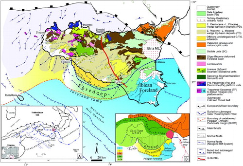
Figure 1. Geological-structural map of Sicily (modified after CitationBigi et al., 1992; CitationCatalano, 2013; CitationCatalano, Agate et al., 2013; CitationCatalano, Valenti et al., 2013; CitationValenti, 2011 and from geological maps compiled in the frame of the Vigor project (CitationVIGOR website, 2013)). The inset A) shows the schematic structural map of the central Mediterranean (modified after CitationCatalano, Agate et al., 2000; CitationCatalano, Valenti et al., 2013; Ionian detailed data from CitationValenti, 2010; see also the inset in the Main Map. The inset B) illustrates the main tectonic elements characterizing the collisional complex of Sicily: (1) the undeformed Pelagian-Iblean foreland, (2) the present-day foredeep; (3) the orogenic wedge: the Calabrian-Peloritani units(3a), the main FTB (3b-c) southwards buried by the Gela Thrust System (3d) in its turn partially covered by the Gela foredeep. BUPP: boundary of the Undeformed Pelagian Platform (after CitationCatalano, Valenti et al., 2013).
Since the proposed map points out a likely target for geothermal drilling, it can also be used as a rough indicator of expected drilling cost of a geothermal project eventually planned for the area. The cost of a geothermal project is in fact closely dependent on the drilling depths, being the related costs heavily weighing on the final budget of the project. Beside its geological importance, this map is, therefore, a useful planning tool for any geothermal project to be carried out in the Sicily region. The study here presented concentrated on the main Island of Sicily (), as the smaller surrounding islands were not taken into account for this modeling.
2. Study area
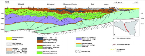
Sicily is a segment of the Apenninic-Tyrrhenian system (, inset A) whose build up refers to both the post-collisional convergence between Africa and a complex ‘European’ crust (CitationBonardi, Cavazza, Perrone, & Rossi, 2001) and to the coeval roll-back of the subduction hinge of the Adriatic Ionian-African lithosphere (CitationDoglioni et al., 1999, CitationFaccenna, Piromallo, Crespo-Blanc, Jolivet, & Rossetti, 2004; CitationChiarabba, De Gori, & Speranza, 2008). This geodynamic process is believed to be also related to the two-phase opening of the Ligurian/Provençal basin and the Tyrrhenian Sea respectively and the continuing northward slow advance of the African lithospheric plate (CitationGoes et al., 2004; CitationGueguen, Doglioni, & Fernandez, 1998). The orogen is located in the center of the Mediterranean, at the NE corner of the Pelagian platform of North Africa, and is connected across the straits of Messina with the Apennine-Alpine orogenic system of Europe (, inset A). Sicily links the Southern Apennine and the Calabrian Arc to the Tellian and Atlas systems of North Africa ( inset A). The collisional complex of Sicily and its offshore continuation ( and inset B, ) consists of: (i) a foreland area, cropping out in south-eastern Sicily (Iblean Plateau) and also submerged in the Pelagian Sea; (ii) a narrow NW-dipping recent foredeep, weakly deformed and partly buried on land and in the offshore Gela Basin; (iii) a complex stack of E- and SE-vergent thrust imbricates, locally more than 20 km thick (, CitationCatalano, Agate et al., 2013; CitationCatalano, Valenti et al., 2013). The orogen, formed by the Kabilian-Calabrian units and the Sicilian units also known as Sicilian Maghrebides (CitationCatalano, Di Stefano, Sulli, & Vitale, 1996; CitationCatalano et al., 2000a; CitationGugliotta et al., 2014; CitationLentini, Carbone, & Catalano, 1994; CitationNigro & Renda, 2002; CitationRoure, Howell, Muller, & Moretti, 1990), is stacked on the Iblean-Pelagian foreland. The simplified structural map of shows the surface distribution of the main tectono/stratigraphic units in Sicily. The stratigraphic and sedimentary characteristics of the different rock units exposed within the foreland fold and thrust belt are briefly summarized in the synopsis of (inspired to CitationCatalano & D'Argenio, 1982). The structure of the mainland of Sicily has been illustrated by several deep geological cross sections crossing both Western and Eastern Sicily from North to South that constrain a broadly accepted common architecture for the orogen of Sicily (e.g. CitationBianchi et al., 1989; CitationBello, Franchino, & Merlini, 2000; CitationCatalano, 2013; CitationCatalano, Agate et al., 2013; CitationCatalano, Franchino, Merlini, & Sulli, 2000a; CitationCatalano, Franchino, Merlini, & Sulli, 2000b; CitationCatalano, Merlini, & Sulli, 2002; CitationCatalano et al., 2004; CitationCatalano, Valenti et al., 2013; see also CitationFinetti et al., 2005; CitationGranath & Casero, 2004 and references therein). The several geological transects show the Sicily fold/thrust belt (FTB) tectonic style consisting of nappes, ramp to flat units and duplex structures (CitationCatalano et al., 1996; CitationRoure et al., 1990;). Recently the SI.RI.PRO crustal profile () acquired between the Northern coast of Sicily and the Gela onshore ((a)), together with refraction seismic, gravimetry and magnetotelluric data (CitationAccaino et al., 2011, more in detail reported in CitationCatalano, Valenti et al., 2013), confirmed the internal architecture of the chain as revealed by the previous and above quoted researches; the resulting crustal geological cross-section () based on the depth converted seismic interpretation, boreholes data, field geology and geophysical constraints clearly revealed the structural architecture at depth. As evidenced by these studies the Sicily structural grain consists essentially of a carbonate accretionary wedge, mainly made up of deep water Meso-Cenozoic carbonate units, overriding a more than 10-km thick platform carbonate thrust wedge which is, in turn, detached from a crystalline basement.
Figure 2. Stratigraphy and original facies domains of the Mesozoic-Cenozoic rock bodies deposited prior to the onset of Miocene deformation. Miocene-Pleistocene deformed foreland and wedge top basin deposits, progressively involved in the deformation, follow upwards. The main tectono-stratigraphic events in Sicily as well as in the central Mediterranean, providing an overview of the many supra-regional episodes that affected the tectonic evolution of Sicily are reported (modified after CitationCatalano, 2013, inspired to CitationCatalano & D'Argenio, 1982).
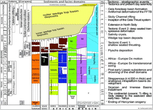
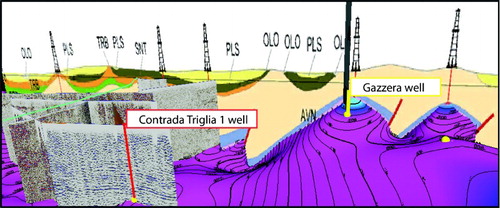
Figure 3. Geological cross-section resulting from the interpretation of the seismic stack section of the SI.RI.PRO. crustal profile and its south-eastern commercial multichannel seismic extension (after CitationCatalano, Valenti et al., 2013). (A) Location map of the SI.RI.PRO crustal profile. The interpreted top of the carbonate regional geothermal reservoir is reported as a dotted yellow line.
In detail, the orogen of Sicily appears characterized by four main structural levels (, see also CitationBello et al., 2000; CitationCatalano et al., 2000a; CitationFinetti et al., 2005) stacked above the autochthonous Iblean foreland or above the mildly deformed Sciacca offshore (CitationCatalano et al., 1978, Citation2000b), located in coastal to offshore southwestern Sicily (CitationArgnani, Cornini, Torelli, & Zitellini, 1989; CitationCatalano, D'Argenio, & Torelli, 1989). The lowest level results from a Meso-Cenozoic mostly carbonate platform S-vergent imbricate fan (PrePanormide and Panormide, Trapanese-Saccense and internal (present day north) Iblean units) forming the main bulk of the chain (). The overlying level is a wedge of mostly warped, originally flat-lying Meso-Cenozoic deep water carbonate thrust sheets (Imerese and Sicanian units) that overthrust the deformed carbonate platform as well the external (southern) Iblean foreland rock units (). The above level is a wedge formed by the Sicilide nappes stacked over deformed terrigenous Oligo-Miocene Numidian flysch (see also CitationBianchi et al., 1989). These units appear to underlie the Calabrian (Peloritains) ‘backstop’ units (the fourth and the higher structural level, see map on ). Progressively deformed, upper Miocene-lower Pliocene clastic, evaporitic and pelagic deposits that filled the ‘older’ wedge top basins, are later involved to build up the Gela thrust system the present day frontal wedge of the Foreland Fold and Thrust Belt (FFTB), ( and ) that thins towards both the Iblean foreland (CitationLickorish, Grasso, Butler, Argnani, & Maniscalco, 1999) and the offshore southern Sicily (CitationCatalano et al., 2000b; CitationGhisetti, Gorman, Grasso, & Vezzani, 2009), where it is submerged (). The tectonic wedge is the result of the underthrusting of the carbonate platform units, that acted through deep-seated progressively younger thrusts in the original carbonate platform sedimentary prism, inducing late stage refolding, further shortening of the previously emplaced nappes, and fault propagation folds in the Neogene cover (see ).
The timing of the deformation of thrust imbrication in Sicily is bracketed between Miocene and middle Pleistocene (CitationOldow et al., 1990). Following the early Miocene ‘collision’ of the Sardinia Block with the African margin (for a detailed reconstruction see CitationCarminati & Doglioni, 2012), the FFTB started to build up with the internal imbrication of the already far traveled crystalline Calabrian (Peloritani) ‘backstop’ units (CitationFaccenna, Speranza, D'Ajello Caracciolo, Mattei, & Oggiano, 2002) and its emplacement over the Sicilide and Numidian flysch nappes (CitationBonardi et al., 2001, ). The latter were decoupled from their substrate and transported over the more external Sicilian domains between Langhian to early Tortonian (CitationCatalano et al., 1996). The progressive detachment of the more internal Meso-Cenozoic deep water carbonate units from their basement and their transport above the still rooted internal carbonate platform units occurred during the middle-late Miocene. The uncoupling of the carbonate platform rocks from the basement and their duplexing took place during the latest Miocene middle Pleistocene, with the development of younger faults offsetting the earlier and overlying structures (CitationCatalano et al., 2000b). Palinspastic restoration of the present-day structural edifice defines the pre-orogenic evolution of this part of the Tethian domain. Main tectono-sedimentary episodes are reported in .
3. Methods
The study of all existing well log information and in particular fluid temperature and pressure data, combined with the interpretation of available hydro-geochemical data of the island of Sicily (CitationCNR, 1982; CitationMontanari et al., 2013) allowing us to locate the main regional-scale geothermal reservoir within the Mesozoic limestones and dolostones (). An integrated review of existing geological and geophysical data (mainly acquired during oil and gas exploration), and the combination with new data from particular key areas, was used for the 3D reconstruction of the top of this regional reservoir. As a first step, we collected and analysed all available geological maps and surface data with the aim to compile an updated geological map for the whole Sicily able to homogenize all the different existing products (see CitationVIGOR web site, 2013). The analysis of this map allowed us to identify areas where the regional geothermal reservoir extensively crops out (). For these areas, the reconstructed surface thus coincides with the topography that we obtained from the digital elevation model, for this purpose we used the (75 meters) Digital Elevation Model provided as WCS (Web Coverage Service) by the Italian National Geoportal (CitationItalian National Geoportal web site, 2012). For the reconstruction of this surface in the areas where it is buried, we used all the direct and indirect available data we could collect from public sources. The most effective way to constrain the surface at depth is definitely the control provided by well data. We used geothermal well data organized in the Italian National Geothermal Database (CitationGeothopica, 2012), and managed by the National Research Council (CNR) and, mainly, hydrocarbon exploratory wells, with data liberalized and provided to the community by the Italian Ministry of Economic Development (CitationMISE web site, 2012). We studied the log of each well and identified the depth at which the regional geothermal reservoir was reached. This depth was then converted in elevation (metres below sea level). We collected and elaborated 299 well logs for the Sicily region (726,728 meters of cumulative length), 92 of which reach the reservoir top. The remaining wells, too shallow to hit the reservoir, were used in the reconstruction as control points indicating the areas where the reservoir was deeper than the wells. Well information is unfortunately intrinsically scattered and not consistently deep; so, geophysical data (seismics, gravity, magnetic, magnetotellurics) may be useful to deduce a more continuous information of the sought carbonate units. Geological cross sections or eventually 3D volume models may be so built on the basis of integrated information from wells and geophysical data interpretation. For the reconstruction of the top of regional geothermal reservoir, we used seismic sections from literature or kindly provided by Eni S.p.A. Specific geological cross-sections have been drawn in the frame of the VIGOR Project (CitationVIGOR website, 2013) and calibrated using well data, seismic profiles, geological maps and geological data from surface. For each profile, we identified several points indicative of the elevation of this important surface. Where direct information on the fluids characteristics and temperature were missing, we assumed that the top of the regional geothermal reservoir matches the top of the Mesozoic carbonates, often easily decipherable. Starting from all these measured points, we used the Petrel convergent algorithm to build the surface. shows the location of wells and the traces of the geological profiles used as input for the 3D modeling (). Among geophysical data, gravity data have the best area distribution in Sicily and are useful because of the high-density contrast expected between the volcanic or carbonate rocks and light deposits. So, our reconstruction of the buried carbonate units of the Sicily region was also based on geophysical modeling of the available Bouguer and free-air gravimetric data (CitationCarrozzo, Luzio, Margiotta, & Quarta, 1986; CitationISPRA, ENI, OGS, 2009), constrained from deep boreholes information. We use a 3D method by CitationFedi (1997) providing the reconstruction of the carbonate top surface according to at least two depth constraints (top and bottom of this surface). The method was chosen also because not requiring any a priori estimate of the density contrast. By this approach, we obtain an interface describing the trend of the top of the carbonate rock body in a large part of the Sicily region. The maximum depth resulted in the area of Caltanissetta Basin and the general trend shows an increase in the carbonate surface towards the western areas of the Sicily islands and a gradual deepening towards the Ionian area. Gravimetry data calibrated with well data, where available, were hence used to constrain those parts of the region lacking well data or seismic and geological profiles. These gravity models were also used for validating the 3D geological modeling.
Figure 4. Exposed mesozoic carbonates constituting the regional geothermal reservoir, (a) Sparagio Mt., (b), Montagna Grande, (c) and (d) Sclafani Bagni, (e) Balatelle Quarry. The location of the photographs is also given.
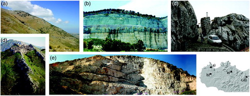
Figure 5. Central and Western Sicily. Areas in which the top of the geothermal reservoir matches with the topography, the thermal springs are also sited. In eastern Sicily the reservoir is mostly buried.
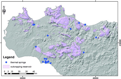
Figure 6. Sicily base map showing the location of wells and the traces of geological cross sections and seismic profiles utilized for the reconstruction of the top of the geothermal reservoir surface.
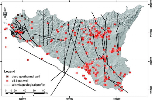
Figure 7. Exemplificative view of the integration between different data (borehole stratigraphy, seismic profiles, and geological cross sections) during the 3D modeling, the purple surface represents the top reservoir surface during a step of the modeling approach.
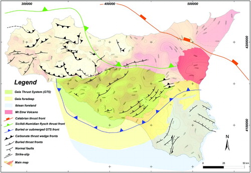
To provide a more complete information on the distribution of the geothermal reservoir with respect to the structural setting, we superimposed the main regional structures on the map of the reservoir top (). This sketch helps to clarify locally the relationships between the reconstructed geometries and the main tectonic structures. However, we should be aware that in the case of a well-developed thrust-tectonic with multiple décollement levels as in the case of Sicily, any attempt of correlation between surface structures with geometries at depth may be poorly constrained or even meaningless.
Figure 8. Sketch illustrating the overly of the main regional structures on the map of the reservoir top (based on CitationBigi et al., 1992; CitationCatalano, 2013; CitationCatalano, Agate et al., 2013; CitationCatalano, Valenti et al., 2013).
4. Conclusions
At the beginning of a geothermal project at a regional scale or just when you need to identify where are the most favorable places to explore, the first thing you want to know is the depth, although indicative, of the potential top of the geothermal reservoir. At that time, you would also to know if it really contains some thermal fluids and what is their temperature. Starting from a great number and variety of geological and geophysical data, our approach was to use 3D geological modeling to reconstruct the depth map of the top of the regional geothermal reservoir in Sicily. The resulting map (Main Map) describes the depth distribution of this potential drilling target in the various areas of Sicily, providing also a basic input for other researches and evaluation of geothermal resources. The information provided by the map can be used to roughly estimate the cost of any geothermal projects to be implemented on this Italian region. Finally, this map could be also used for many geological reconstructions, domestic water supply investigations, and for Carbon Capture and Sequestration projects as it indicates the occurrence and the geometry of structural traps that could be taken into account for this kind of projects.
Software
The map related data were organized, managed and processed using ESRI ArcGIS 9.2 and QGIS (CitationQuantum GIS Development Team, 2012) v1.8 (compiled from source). Gravimetric data analysis was carried out using an algorithm developed in the MATLAB Environment and described in CitationFedi (1997). The three-dimensional geological modeling and mapping was carried out using ‘PETREL’ (Schlumberger). Finally, cartographic design was performed using Adobe Illustrator.
Main Map: Contour Map of the Regional Geothermal Reservoir of Sicily (Italy)
Download PDF (7.5 MB)Acknowledgements
The present research has been performed in the frame of the VIGOR Project, aimed at assessing the geothermal potential and exploring geothermal resources of four regions in southern Italy. VIGOR is part of the activities of the Interregional Programme ‘Renewable Energies and Energy Savings FESR 2007–2013 – Axes I Activity line 1.4 “Experimental Actions in Geothermal Energy’”. The authors acknowledge the management of VIGOR Project, and in particular Dr. Piezzo of MiSE-DGENRE (Directorate General for Nuclear Energy, Renewable Energy and Energy Efficiency of the Ministry for Economic Development) and Dr. Brugnoli, Director of CNR-DTA (National Research Council of Italy, Department of Sciences of the Earth System and Environmental Technologies). We thank Roberto De Franco, Grazia Caielli and Gianluca Norini (CNR-IDPA) for providing help during seismic profiles editing.
Related Research Data
References
- Accaino, F., Catalano, R., Di Marzo, L., Giustiniani, M., Tinivella, U., Nicolich, R., … Manetti, P. (2011). A crustal seismic profile across Sicily. Tectonophysics, 508, 52–61. doi: 10.1016/j.tecto.2010.07.011
- Alaimo, R., Carapezza, M., Dongarrà, G., & Hauser, S. (1978). Geochimica delle sorgenti termali siciliane. Rendiconti della Società Italiana di Mineralogia e Petrologia, 34, 577–590.
- Argnani, A., Cornini, S., Torelli, L., & Zitellini, N. (1989). Neogene-Quaternary Foredeep system in the Strait of Sicily. Memorie della Società Geologica Italiana, 36, 123–130.
- Bello, M., Franchino, A., & Merlini, S. (2000). Structural model of eastern sicily. Memorie della Società Geologica Italiana, 55, 61–70.
- Bianchi, F., Carbone, S., Grasso, M., Invernizzi, G., Lentini, F., Longaretti, G., … Mostardini, F. (1989). Sicilia orientate: profilo geologico Nebrodi-Iblei. Memorie della Società Geologica Italiana, 38, 429–458.
- Bigi, G., Bonardi, G., Catalano, R., Cosentino, D., Lentini, F., Parotto, M., … Turco, E. (Eds) (1992). Structural model of Italy: Progetto Finalizzato Geodinamica. Rome: CNR-GNDT. scale 1:500,000, 1 sheet.
- Bonardi, G., Cavazza, W., Perrone, V., & Rossi, S. (2001). Calabria–Peloritani Terrane and Northern Ionian Sea. In G. B. Vai, & P. Martini (Eds.), Anatomy of an Orogen: The apennines and adjacent mediterranean basins (pp. 287–306). Dordrecht/Boston/London: Kluwer Academic Publishers.
- Carminati, E., & Doglioni, C. (2012). Alps vs Apennines: The paradigm of a tectonically asymmetric. Earth Science Reviews, 112, 67–97. doi: 10.1016/j.earscirev.2012.02.004
- Carrozzo, M. T., Luzio, D., Margiotta, C., & Quarta, T. (1986). Gravity anomaly map of Italy. CNR: “Progetto Finalizzato Geodinamica” – Sottoprogetto: “Modello Strutturale Tridimensionale”.
- Catalano, R. (2013). Sicily's fold/thrust belt. An introduction to the field trip. In R. Catalano, M. Agate, et al., (Eds.), Walking along a crustal profile across the Sicily fold and thrust belt. AAPG International Conference & Exhibition – Milan 2011 Geological field trips Vol.5 No.2.3, 213 pp., 121 figs, 8 pls, 4 tabs. doi:10.3301/GFT.2013.05
- Catalano, R., Agate, M., Albanese, c., Avellone, G., Basilone, l., Gasparo Morticelli, M., … Pierini, S. (2013a). Walking along a crustal profile across the Sicily fold and thrust belt. AAPG International Conference & Exhibition – Milan 2011, Geological field trips Vol.5 No.2.3, 213 pp., 121 figs, 8 pls, 4 tabs. doi:10.3301/GFT.2013.05
- Catalano, R., & D'Argenio, B. (1982). Schema Geologico della Sicilia. In R. Catalano, & B. D'Argenio (Eds.), Guida alla geologia della Sicilia occidentale. Società Geologica Italiana, Guide geologiche regionali (pp. 9–41). Palermo: Società Geologica Italiana.
- Catalano, R., D'Argenio, B., Montanari, L., Renda, P., Abate, B., Monteleone, S., … Agnesi, V. (1978). Contributi alla conoscenza della struttura della Sicilia occidentale 1) il profilo Palermo-Sciacca. Memorie della Società Geologica Italiana, 19, 485–493.
- Catalano, R., D'Argenio, B., & Torelli, L. (1989). From Sardinia Channel to Sicily Strait. A geologic section based on seismic and field data. In The Lithosphere in Italy, Acc. Naz. dei Lincei, Atti dei Convegni Lincei, 80, 109–127.
- Catalano, R., Di Stefano, P., Sulli, A., & Vitale, F. P. (1996). Paleogeography and structure of the central Mediterranean: Sicily and its offshore area. Tectonophysics, 260, 291–323. doi: 10.1016/0040-1951(95)00196-4
- Catalano, R., Franchino, A., Merlini, S., & Sulli, A. (2000a). Central western Sicily structural setting interpreted from seismic reflection profiles. Memorie della Società Geologica Italiana, 55, 5–16.
- Catalano, R., Franchino, A., Merlini, S., & Sulli, A. (2000b). A crustal section from the Eastern Algerian basin to the Ionian ocean (Central Mediterranean). Memorie della Società Geologica Italiana, 55, 71–85.
- Catalano, R., Merlini, S., & Sulli, A. (2002). The structure of western Sicily, central Mediterranean. Petroleum Geoscience, 8, 7–18. doi: 10.1144/petgeo.8.1.7
- Catalano, R., Sulli, A., Abate, B., Agate, M., Avellone, G., & Basilone, L. (2004). The crust in Western and Central Eastern Sicily. In Field Trip Guide Book P45, 32nd International Geological Congress, Florence, 20–28 August 2004.
- Catalano, R., Valenti, V., Albanese, C., Accaino, F., Sulli, A., Tinivella, U., … Giustiniani, M. (2013). Sicily's fold–thrust belt and slab roll-back: the SI.RI.PRO. seismic crustal transect. Journal of the Geological Society, 170, 451–464. doi:10.1144/jgs2012-099.
- Chiarabba, C., De Gori, P., & Speranza, F. (2008). The southern Tyrrhenian subduction zone: deep geometry, magmatism and Plio-Pleistocene evolution. Earth and Planetary Science Letters, 268, 408–423. doi: 10.1016/j.epsl.2008.01.036
- Consiglio Nazionale Ricerche (CNR). (1982). Contributo alla conoscenza delle risorse geotermiche del territorio. Rome, Italy: CNR publisher, PFE, RF-13, 120 pp.
- Dall'Aglio, M., & Tedesco, C. (1968). Studio geochimico ed idrogeologico di sorgenti della Sicilia. Rivista Mineraria Siciliana, Anno 19, N.112/114, 171–210.
- Della Vedova, B., Bellani, S., Pellis, G., & Squarci, P. (2001). Deep temperatures and surface heat flow distribution. In G. B. Vai, & I. P. Martini (Eds.), Anatomy of an Orogen. The Apennines and adjacent Mediterranean basins (pp. 65–76). Great Britain: Kluwer Ac. Publ.
- Doglioni, C., Harabaglia, P., Merlini, S., Mongelli, F., Peccerillo, A., & Piromallo, C. (1999). Orogens and slabs vs. their direction of subduction. Earth-Science Reviews, 45, 167–208. doi: 10.1016/S0012-8252(98)00045-2
- Faccenna, C., Piromallo, C., Crespo-Blanc, A., Jolivet, L., & Rossetti, F. (2004). Lateral slab deformation and the origin of the western Mediterranean arcs. Tectonics, 23-1. 21 pp. doi:10.1029/2002TC001488
- Faccenna, C., Speranza, F., D'Ajello Caracciolo, F., Mattei, M., & Oggiano, G. (2002). Extensional tectonics on Sardinia (Italy): Insights into the arc–back-arc transitional regime. Tectonophysics, 356, 213–232. doi: 10.1016/S0040-1951(02)00287-1
- Fancelli, R., Monteleone, S., Nuti, S., Pipitone, G., Rini, S., & Taffi, L. (1991). Nuove conoscenze idrogeologiche e geotermiche nella Sicilia occidentale. Geologia applicata e idrogeologia, 24, 24 pp.
- Fedi, M. (1997). Estimation of density, magnetization, and depth to source: A nonlinear and noniterative 3-D potential-field method. Geophysics, 62(3), 814–830. doi: 10.1190/1.1444191
- Finetti, I. R., Lentini, F., Carbone, S., Del Ben, A., Di Stefano, A., Forlin, E., … Prizzon, A. (2005). Geological outline of Sicily and litospheric tectono-dynamics of its Tyrrhenian Margin from new CROP seismic data. In I. R. Finetti (Ed.), CROP Project: Deep seismic exploration of the Central Mediterranean and Italy. Atlases in Geoscience, 1 (794pp). Amsterdam: Elsevier.
- Geothopica web site. (2012). Italian National Geothermal Database [online]. Retrieved January 14, 2014, from http://geothopica.igg.cnr.it/
- Ghisetti, F. C., Gorman, A. R., Grasso, M., & Vezzani, L. (2009). Imprint of foreland structure on the deformation of a thrust sheet: The Plio-Pleistocene Gela Nappe (southern Sicily, Italy). Tectonics, 28, 16 pp. doi: 10.1029/2008TC002385
- Goes, S., Giardini, D., Jenny, S., Hollenstein, C., Kahle, H. G., & Geiger, A. (2004). A recent tectonic reorganization in the south–central Mediterranean. Earth and Planetary Science Letters, 266, 335–345. doi: 10.1016/j.epsl.2004.07.038
- Gola, G., Manzella, A., Trumpy, E., Montanari, D., & van Wees, J. D. (2013). Deep-seated Geothermal Resource Assessment of the VIGOR Project Regions, Italy. Proceedings of the European Geothermal Congress 2013 Pisa, Italy, 3-7 June 2013. ISBN 978-2-8052-0226-1
- Granath, J. W., & Casero, P. (2004). Tectonic setting of the petroleum systems of Sicily. In R. Swennen, F. Roure, & J. Granath (Eds.), Deformation, Fluid Flow and Reservoir Appraisal in Foreland Fold-and-Thrust Belts. AAPG Hedberg Ser (vol. 1, pp. 391–411). Tulsa, Okla: American Association of Petroleum Geologists.
- Grassa, F., Capasso, G., Favara, R., & Inguaggiato, S. (2006). Chemical and Isotopic of Waters and Dissolved Gases in Some Thermal Springs of Sicily and Adjacent Volcanic Islands, Italy. Pure and Applied Geophysics, 163, 781–807. doi: 10.1007/s00024-006-0043-0
- Gueguen, E., Doglioni, C., & Fernandez, M. (1998). On the post-25 Ma geodynamic evolution of the western Mediterranean. Tectonophysics, 298, 259–269. doi: 10.1016/S0040-1951(98)00189-9
- Gugliotta, C., Gasparo Morticelli, M., Avellone, G., Agate, M., Barchi, M.R., Albanese, C., … Catalano, R. (2014). Middle Miocene–Early Pliocene wedge-top basins of NW Sicily (Italy): Constraints for the tectonic evolution of a ‘non-conventional’ thrust belt, affected by transpression. Journal of the Geological Society, London, 171, 211–226. doi:10.1144/jgs2013-009.
- ISPRA, ENI, OGS. (2009). Cartografia Gravimetrica Digitale d'Italia alla scala 1:250.000.
- Italian National Geoportal web site. (2012). WCS services catalogues [online]. Retrieved January 14, 2014, from http://wms.pcn.minambiente.it/wcs/dtm_75m
- Lentini, F., Carbone, S., & Catalano, S. (1994). Main structural domains of the central Mediterranean region and their Neogene tectonic evolution. Bollettino di Geofisica Teorica e Applicata, 36, 141–144.
- Lickorish, W. H., Grasso, M., Butler, R., Argnani, A., & Maniscalco, R. (1999). Structural styles and regional tectonic setting of the “Gela Nappe” and frontal part of the Maghrebian thrust belt in Sicily. Tectonics, 18(4), 655–668. doi: 10.1029/1999TC900013
- Minissale, A. (1991a). The Larderello geothermal field: a review. Earth Science Review, 31, 133–151. doi: 10.1016/0012-8252(91)90018-B
- Minissale, A. (1991b). Thermal springs in Italy: their relation to recent tectonics. Applied Geochemistry, 6, 201–212. doi: 10.1016/0883-2927(91)90030-S
- MISE web site. (2012). Ministry of economic development – Directorate-general for mineral and energy resources [online]. Retrieved January 14, 2014, from http://unmig.sviluppoeconomico.gov.it/videpi/en/
- Montanari, D., Bertini, G., Botteghi, S., Caielli, G., Caiozzi, F., Catalano, R., … Trumpy, E. (2013). Medium enthalpy geothermal systems in carbonate reservoirs, the Western Sicily example. Proceedings of the European Geothermal Congress 2013 Pisa, Italy, 3-7 June 2013. ISBN 978-2-8052-0226-1.
- Muffler, P., & Cataldi, R. (1978). Methods for regional assessment of geothermal resources. Geothermics, 7, 53–89. doi: 10.1016/0375-6505(78)90002-0
- Nigro, F., & Renda, P. (2002). From Mesozoic extention to Tertiary collision: deformation patterns in the units of the north-western Sicilian Chain. Bollettino della Società Geologica Italiana, 121, 87–97.
- Oldow, J.S., Channell, J.E.T., Catalano, R. and D'Argenio, B. (1990). Contemporaneous thrusting and large-scale rotation in the western Sicilian fold and thrust belt. Tectonics 9. doi:10.1029/89TC03329
- Quantum GIS Development Team. (2012). Quantum GIS Geographic Information System. Open Source Geospatial Foundation Project. Retrieved from http://qgis.osgeo.org
- Roure, F., Howell, D. G., Muller, C., & Moretti, I. (1990). Late Cenozoic subduction complex of Sicily. Journal of Structural Geology, 12(2), 259–266. doi: 10.1016/0191-8141(90)90009-N
- Valenti, V. (2010). Shallow structures at the outer Calabrian accretionary wedge (NW Ionian Sea): New insights from recently migrated reflection data. Terra Nova, 22(6), 453–462. doi: 10.1111/j.1365-3121.2010.00964.x
- Valenti, V. (2011). New insights from recently migrated CROP multichannel seismic data at the outermost Calabrian arc accretionary wedge (Ionian sea). Italian Journal of Geosciences, 130(3), 330–342. doi: 10.3301/IJG.2011.05
- VIGOR website. (2013). Retrieved January 14, 2014, from http://www.vigor-geotermia.it/