
Abstract
The Geological map of the Tellaro River Valley, at the 1:25.000 scale, portrays the main stratigraphic and structural features that developed in a 300 km2 wide area of the African foreland in southeastern Sicily (Hyblean Foreland). The NW-SE-oriented Tellaro River Valley marks the transition between the eastern (Siracusa Plateau) and western (Ragusa Plateau) domains of the foreland, where a post-Tortonian structural depression, here designated as Tellaro Basin, originated. The map pictures the geometry and kinematics of the border faults and the structure affecting the basin infilling. The mapped structural pattern denounces a poliphase tectonic evolution of the region, suggesting the occurrence of a major NW-SE-oriented crustal discontinuity that, being active during the different periods of the post-Tortonian evolution of the area, could play a primary role also in the present seismotectonic picture.
1. Introduction
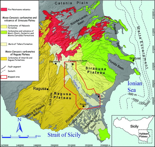
The Hyblean region, in southeastern Sicily, represents the emerged portion of the NE-SW-oriented continental bulge of the African foreland (CitationLentini, Carbone, & Catalano, 1994) that buttressed the thrust front of the eastern Sicily collision belt (CitationRoure, Howel, Muller, & Moretti, 1990), during the post-Tortonian NW-SE-oriented Africa-Europe convergence (CitationDewey, Helman, Turco, Hutton, & Knott, 1989). In the Hyblean Foreland, two distinct tectonic domains, separated by the Tellaro River Valley, can be recognized: the Siracusa Plateau, to the east, and the Ragusa Plateau, to the west, (CitationGhisetti & Vezzani, 1980; CitationGrasso & Lentini, 1982; CitationPedley, Cugno, & Grasso, 1992) (). The Siracusa Plateau is mainly composed of a Late Cretaceous-Late Tortonian shallow-water carbonate succession, resting on Early Cretaceous volcanic edifices, gradually replaced to the west by carbonate ramp deposits, representing the transition to basinal sequences. These latter have been drilled in the western part of the Siracusa Plateau (Rigolizia 001 and Palazzolo 001 well logs from ViDEPI Project data (http://unmig.sviluppoeconomico.gov.it/videpi/en/pozzi/gruppo.asp?ub=T®ione=Sicilia&provincia=Siracusa) and crop out in both the flanks of the Tellaro River Valley, also characterizing the entire Ragusa Plateau. During the Quaternary, the Hyblean region was fragmented by tectonic features that developed during two distinct extensional episodes. The former, governed by a NW-SE-oriented extension, consisted of the widespread reactivation of the NE-SW trending faults of the bulge, coincident with the dextral remobilization of the Scicli Line, inherited from a Late Cretaceous tectonic lineament, dissecting the Ragusa Plateau (CitationCatalano et al., 2008a; CitationGrasso & Reuther, 1988). This caused the propagation of a fault belt across the entire region, from the northern border of the Siracusa Plateau (Scordia-Lentini Basin) to the southern edge of the Ragusa Plateau (Marina di Ragusa and Ispica-Pachino Basins), associated with the deposition of 1.5 to 0.9 ka syn-tectonic deposits (CitationPedley et al., 2001) (). The second extensional episode, governed by a NE-SW-oriented crustal stretching, affected, since about 850 ka (CitationCatalano, Romagnoli, & Tortorici, 2010), only the Siracusa Plateau where the collapse of the Floridia and Augusta Basins occurred (). During both the two extensional episodes, the Tellaro River Valley represented a main discontinuity in the active tectonic picture, as it earlier confined to the east the NE-oriented extensional features of the Ragusa Plateau and then bounded to the west the NW-trending faults of the Siracusa Plateau.
Figure 1. Geological and structural sketch map of the Hyblean region.
The current geological information, thus, clearly evidences that the modern fragmentation of the Hyblean region has been already evident since Early Quaternary, being almost independent from the Late Cretaceous-Late Tortonian paleogeography, and that the Tellaro River Valley has played the role of a main regional geological discontinuity, in the post-Tortonian tectonic evolution of the region.
The Geological map of the Tellaro River Valley, at the 1:25.000 scale (see Main Map), aims to provide an updated picture of the main stratigraphic and tectonic features of a 300 km2 wide area (see mapped area in ), in order to constrain the different stages of the tectonic separation between the Siracusa and the Ragusa domains of the Hyblean region.
2. Stratigraphy of the Hyblean region
The Hyblean Foreland is made of a Late Cretaceous-Late Tortonian carbonate succession showing shallow water facies, to the east, and basinal facies, to the west, with intermediate carbonate ramp deposits developed between the two paleogeographic domains (CitationGrasso & Lentini, 1982).
The eastern succession, resting on Late Cretaceous volcanic seamounts, shows Rudist reefs basal levels that pass laterally and upwards into breccias containing shallow-water reworked sediments. The succession evolves to Oligo-Miocene calcarenites and algal-rich limestones (Monti Climiti Formation; CitationPedley, 1981). The western sequence consists of basal Late Cretaceous-Eocene cherty marly limestones (Amerillo Formation; CitationPatacca, Scandone, Giunta, & Liguori, 1979; CitationRigo & Barbieri, 1959) that underlies an Oligo-Miocene marly-calcarenitic succession (Ragusa Formation; CitationRigo & Barbieri, 1959). The sequences of the two domains are capped by a Middle-to-Late Miocene westward prograding carbonate ramp (CitationPedley et al., 1992) which is composed of innermost shallow water algal limestones (Siracusa Limestones), locally replaced by volcanics (Carlentini Formation; CitationGrasso, Lentini, & Pedley, 1982), intermediate biocalcarenites (Palazzolo Formation; CitationRigo & Barbieri, 1959) and outermost marls (Tellaro Formation; CitationRigo & Barbieri, 1959).
The Messinian levels, represented by marly limestones and marls forming the top of the Tellaro Formation (CitationDi Grande & Romeo, 1981), are confined in the structural depressions contouring the Ragusa Plateau (Marina di Ragusa and Ispica-Pachino Basins). Lower Messinian lagoonal limestones (Monte Carruba Formation; CitationGrasso et al., 1982; CitationPedley, Grasso, Maniscalco, & Esu, 2007) are preserved at the top of the Siracusa Plateau.
The Plio-Pleistocene deposits fill the structural depressions at the margin of both the Siracusa and Ragusa plateaus, covering the Messinian levels or directly the Tortonian levels.
3. Methods
The geological map of the Tellaro River Valley derived from detailed (1:10.000 scale) geological field mapping that covered an area of about 300 km2 (see study area in and Main Map) including the edges of the Siracusa and the Ragusa plateaus, bordering the eastern and western flank of the valley, respectively. The outcropping terrains have been described as lithostratigraphic units, according to the classical stratigraphic schemes of the region (CitationDi Grande, Romeo, & Raimondo, 1982; CitationPedley, 1981; CitationRigo & Barberi, 1959). The studied sequences have been grouped in three distinct successions related to the Siracusa Plateau, the Ragusa Plateau, and the Tellaro River Valley, respectively (see Main Map). This distinction was adopted to state the different tectono-stratigraphic evolution of the two adjacent plateaus and the intermediate depression. The chronology of the mapped terrains was also based on data from biostratigraphic studies carried out in the region (CitationDi Grande & Romeo, 1981; CitationDi Stefano, 1995; CitationMusumeci, 1959; CitationRomeo & Sciuto, 1987). The study included the interpretation of 1:33.000 and 1:10.000 aerial photos. Along the main mapped structures, structural analyses of the geometry and kinematics on mesoscale fault planes have been performed. The scale 1:25.000 adopted for the restitution of the map was considered the best to provide an immediate overall picture of the regional tectonic lineaments, coupled with a fine resolution of data.
4. Stratigraphic units
In this section, we describe the peculiarities of the stratigraphic successions of the Siracusa Plateau, the Ragusa Plateau and the intermediate Tellaro River Valley, taking into account their lithological features that have been detailed in the legend of the Main Map.
4.1. Stratigraphic succession of the Siracusa Plateau
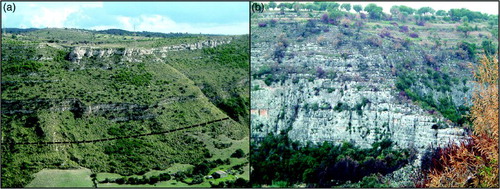
The stratigraphic succession of the Siracusa Plateau ((a)) is exposed along the eastern flank of the Tellaro River Valley. The basal levels consist of the upper Serravallian – Early Tortonian (CitationDi Stefano, 1995; CitationMusumeci, 1959; CitationRomeo & Sciuto, 1987) marls of the Tellaro Formation (CitationRigo & Barberi, 1959), also described as Castelluccio Marls Member (CitationPedley, 1981). This pelagic units gradually passes to the Tortonian carbonate sequence (CitationDi Grande et al., 1982; CitationDi Stefano, 1995; CitationMusumeci, 1959; CitationRomeo & Sciuto, 1987) of upward coarsening clastic (Palazzolo Formation; CitationRigo & Barbieri, 1959), that deposited at the front of the westward prograding carbonate ramp (CitationPedley et al., 1992), fed by the eastern sectors of the Hyblean region. The transition from the pelagic to the detritic levels is heralded by lenses of a thin-bedded alternation of marls and limestones that are interleaved in the top levels of the Tellaro Formation, showing several slumped horizons. The clastic sequence, capping the pelagic levels, varies from lower fine-grained horizons, hosting lens of calcarenites, (Gaetanì Member; CitationDi Grande et al., 1982) to calcarenitic upper levels (Buscemi Member; CitationDi Grande et al., 1982).
Figure 2. (a) Stratigraphic succession of the Siracusa Plateau (the dotted line represents the contact, partly covered by talus, between the Tellaro Formation, at the base and the Palazzolo Formation, at the top); and (b) Stratigraphic succession of the Ragusa Plateau (massively bedded calcarenites, at the base; calcarenites alternated with marls at the top).
4.2. Stratigraphic succession of the Ragusa Plateau
The stratigraphic succession of the Ragusa Plateau ((b)) is exposed along the western flank of the Tellaro River Valley. The lowermost stratigraphic unit is represented by the top levels of the Upper Oligocene-Langhian (CitationGrasso, Pedley, Maniscalco, & Ruggieri, 2000) Ragusa Formation (CitationRigo & Barberi, 1959), here represented by massively bedded (>10 m thick) calcarenites and the overlying calcarenites alternated with marls of the Irminio Member (CitationRigo & Barberi, 1959). The alternation upward grades into a pelagic sequence, consisting of marls with interleaved mudstone levels of the Upper Langhian-Upper Serravallian (CitationDi Stefano, 1995; CitationRomeo & Sciuto, 1987) Tellaro Formation.
4.3. Stratigraphic succession of the Tellaro Basin
Along the Tellaro River Valley, a sequence, made of basal marly clays covered by chaotic coarse-grained deposits, has been mapped in a discrete NW-SE elongated sector bordered by faults, immediately to the northeast of the river course. These terrains have been previously correlated to the stratigraphic sequence, including the Tellaro and the Palazzolo formations, exposed along the western border of the Siracusa Plateau. Actually, the sequence shows peculiar features that suggest a different attribution. The marls of the Tellaro Formation evolve to top decimetric beds of whitish lime mudstones alternated with yellowish marls (see Contrada Renna Alta), that have been dated to the Early Messinian in the whole southern portion of the Ragusa Plateau (CitationDi Grande & Romeo, 1981; CitationGrasso et al., 2000). This is also supported by the occurrence of blocks from the Messinian Tripoli Formation and Gypsum (CitationMusumeci, 1959). Moreover, the overriding chaotic eterometric carbonate breccias actually form lenses channelized within the white cream coloured pelagic mudstone and limestone of the Lower-Middle Pliocene Trubi Formation (Grasso et al., 1987). These evidences, constraining a Messinian to Middle Pliocene age, indicate that the sequence cropping out along the floor of the Tellaro River Valley is younger than those exposed along the flanks and represents the syn-tectonic filling of a structural depression bordered by faults, here designed as Tellaro Basin (see Stratigraphic columns in Main Map).
4.4. Quaternary deposits
The youngest marine sediments cropping out in the investigated area are represented by white-yellowish bioclastic Early Quaternary (CitationCarbone, Grasso, & Lentini, 1987) calcarenites, cropping out near the village of Noto. The Quaternary deposits, unconformably covering different horizons of the Messinian-Pliocene sequence, infill a depocenter bounded by faults that caused the tectonic collapse of the southeastern sector of the Tellaro Basin. The syn-tectonic nature of these deposits is demonstrated by the occurrence of associated limnic levels showing diffuse slumps.
Early-Middle Pleistocene (CitationCarbone, Di Geronimo, Grasso, Iozzia, & Lentini, 1982) terraced marine deposits, frequently capped by continental conglomerates, travertines and red-soils, rest on abrasion surfaces as elevated as 300 a.s.l., concealing the fault segments bordering the southern sectors of the Tellaro Basin.
Finally, the course of the Tellaro River, which is entrenched along the southwestern boundary of the Tellaro Basin is flanked by different orders of fluvial terraces. They show an asymmetric distribution with regards to the present location of the stream, being more diffused on the eastern flank, where they reach a maximum elevation of about 450 m a.s.l.
5. Structural features
The new field data revealed the existence of a 3 km wide and 23 km long NW-SE-oriented structural depression, here designed as Tellaro Basin, flanking to the east the middle and lower course of the Tellaro River (see Main Map). This depression formed by the collapse of the pre-Messinian sequence and was filled with Messinian to Middle Pliocene pelagic deposits, showing repeated intercalations of calcarenites, slumps, coarse-grained breccias with local large-size carbonate blocks. The collapsed basin developed in the interference area between two NW-SE trending fault zones. The one controlling the western side of the depression is composed of two right-stepping NE-dipping segments, each showing a length of about 13 km and high-angle geometry. The location of restraining and releasing bends along the two fault segments is expressive of a dominant left-lateral component of motion along these structures. The fault zone interrupts several NE-SW oriented, SE dipping fault segments dissecting the Ragusa Plateau, along which two distinct generations of striae (pitch = 10 and pitch = 100) have been recognized (see stereoplot 1 in Main Map).
The shear zone, which controls the opposite side of the Tellaro Basin, extends for about 20 km and is composed of distinct anastomosing fault segments that developed along a prominent N140–150° trending and SW-dipping segment. This master fault ((a)), despite of its low-angle geometry (dip ≤ 45°), shows the effects of an almost pure left-lateral strike-slip motion (see stereoplots 2 and 3 in Main Map). At the northern as well as at the southern tip, the main fault segment terminates into N100°-oriented fault zones ((b)). The northern one developed as a releasing bend that links the N140° segment to the border fault on the opposite side of the depression. At the southern tip, conversely, the fault bend evolved in a pull-apart basin, filled with the Lower Pleistocene calcarenites in the Noto area.
Figure 3. (a) Low-angle border fault along the eastern side of the Tellaro Basin in Contrada Renna Alta; (b) fault segments of the N100° oriented shear zone, linking the eastern and the western border faults, along the northern margin of the Tellaro Basin; and (c) imbricated thrust on Middle Pliocene calcareous breccias, splaying from the fault segment of Contrada Renna Alta.
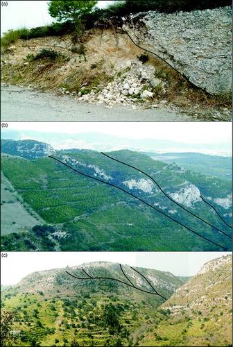
In the southern portion of the Tellaro Basin, the Messinian-Pliocene syn-tectonic deposits are affected by contractional structures, which are represented by folds and imbricated thrust fans that are almost parallel to the eastern border fault ((c)). A different generation of N80° folds (see p-axis diagram in Main Map) affected the Lower Pleistocene calcarenites deposited in the Noto area, at the southern termination of the eastern border fault. These contractional structures as well as the fault segments of the shear zone are concealed by the Middle Pleistocene marine terraces (CitationCatalano, De Guidi, Monaco, Tortorici, & Tortorici, 2008b).
6. Tectonic evolution of the Tellaro Basin and Conclusions
The geological map of the Tellaro River Valley provides an updated description of the main post-Tortonian tectonic features that have controlled the fragmentation of the Hyblean Foreland, with the separation between the Ragusa and Siracusa Plateaus, during the late stages of the tectonic bulging of the area. The present flower geometry reconstructed across the Tellaro River Valley (see geological sections in the Main Map), coherent with the prevalent left-lateral kinematics measured on fault planes, is the result of a polyphase tectonic evolution of the transition zone between the two plateaus. A former extensional stage (Messinian to Middle Pliocene in age) is suggested by the development of low-angle SW-dipping border faults, on the Siracusa side of the depression, faced by antithetic high-angle NE-dipping segments, on the Ragusa side. The tectonic inversion of these border faults, from extensional to trascurrent, that nucleated the flower structure is highlighted by the coincident contractional deformation of the basin infilling and the overall relief inversion that can be appreciated between the Tellaro Basin area and the adjacent margin of the Ragusa Plateau (see geological sections in the Main Map). This is also emphasized by the present position of the river that migrated away from the depocenter of the Tellaro Basin, towards the margin of the Ragusa Plateau. The final stage of the deformation within the Tellaro Basin consists of gentle folding of the Lower-Middle Quaternary deposits, coherent with the active NW-SE-oriented Nubia-Eurasia convergence (CitationHollenstein et al., 2003; CitationMusumeci, Patanè, Scarfì, & Gresta, 2005; CitationRagg, Grasso, & Muller, 1999).
In conclusion, the new map of the Tellaro River Valley constrains the existence of major NW-SE-oriented shear zones, bordering a Messinian-Pliocene basin, that have played the role of main regional geological discontinuities, in the post-Tortonian tectonic evolution of the Hyblean Foreland. During this period, the shear zones accommodated in fact the relative motions between the Ragusa and Siracusa domains of the Hyblean Plateau, with dynamics and kinematics, changing in the time from extensional to left-lateral, that suggests a local transient rotation of the axis of compression, apart from the regional one. The restoration of the active NW-SE compression in the region of the Tellaro Basin coincides with the end of the left-lateral motions along the border fault zones. Nevertheless, the Late Quaternary growing of folds strongly suggests to dedicate further investigations to test the possible role of the major NW-SE-oriented fault segments also in the seismotectonic picture of the region that is one of the most active seismogenic area of the Mediterranean.
Main Map: Geological Mapo f the Tellaro River Valley (Hyblean Foreland, Southeastern Sicily, Italy)
Download PDF (15.4 MB)Software
The geological map has been digitized using ESRI ArcGIS 10.2 software, on the base of a georeferenced original hand-coloured geological map. The geological sections, the stratigraphic columns, the structural sketch map, the stereoplots and the legend have been assembled using CorelDraw X4 software.
Related Research Data
References
- Carbone, S., Di Geronimo, I., Grasso, M., Iozzia, S., & Lentini, F. (1982). I terrazzi marini quaternari dell'area iblea (Sicilia sud-orientale). C.N.R. – Progetto finalizzato geodinamica – Sottoprogetto neotettonica. Contributi conclusivi per la realizzazione della Carta Neotettonica d'Italia. Pubbl. n. 506, pp. 1–35.
- Carbone, S., Grasso, M., & Lentini, F. (1987). Lineamenti geologici del Plateau Ibleo (Sicilia S.E.): Presentazione delle carte geologiche della Sicilia sud-orientale. Memorie Società Geologica Italiana, 38, 127–135.
- Catalano, S., De Guidi, G., Monaco, C., Tortorici, G., & Tortorici, L. (2008b). Active faulting and seismicity along the Siculo-Calabrian rift zone (Southern Italy). Tectonophysics, 453, 177–192. doi:10.1016/j.tecto.2007.05.008
- Catalano, S., De Guidi, G., Romagnoli, G., Torrisi, S., Tortorici, G., & Tortorici, L. (2008a). The migration of plate boundaries in SE Sicily: Influence on the large-scale kinematic model of the African promontory in southern Italy. Tectonophysics, 449, 41–62. doi:10.1016/j.tecto.2007.12.003
- Catalano, S., Romagnoli, G., & Tortorici, G. (2010). Kinematics and dynamics of the late quaternary rift-flank deformation in the Hyblean Plateau (SE Sicily). Tectonophysics, 486, 1–14. doi:10.1016/j.tecto.2010.01.013
- Dewey, J. F., Helman, M. L., Turco, E., Hutton, D. H. W., & Knott, S. D. (1989). Kinematics of the western Mediterranean. Geological Society, London, Special Publications, 45, 265–283. doi: 10.1144/GSL.SP.1989.045.01.15
- Di Grande, A., & Romeo, M. (1981). Caratteri-lito-biostratigrafici dei depositi messiniani nell'area iblea (Sicilia sud-orientale). Rivista italiana di paleontologia, 86(4), 855–916.
- Di Grande, A., Romeo, M., & Raimondo, W. (1982). Il Membro di Gaetanì ed il Membro di Buscemi della Formazione Palazzolo: Facies, distribuzione ed età. Bollettino Della Societa Geologica Italiana, 101, 343–372.
- Di Stefano, A. (1995). Biostratigrafia a nannofossili calcarei dei sedimenti medio-supramiocenici del settore occidentale del Plateau Ileo (Sicilia sud-orientale). Bollettino della Società Paleontologica Italiana, 34, 147–162.
- Ghisetti, F., & Vezzani, L. (1980). The structural features of the Hyblean Plateau and the Mount Judica area (South-Eastern Sicily): A microtectonic contribution to the deformational history of the Calabrian Arc. Bollettino Della Societa Geologica Italiana, 99, 55–102.
- Grasso, M., & Lentini, F. (1982). Sedimentary and tectonic evolution of the eastern Hyblean Plateau (Southeast Sicily) during Late Cretaceous to Quaternary time. Paleogeography, Paleoclimatology, Palaeoecology, 39, 261–280. doi: 10.1016/0031-0182(82)90025-6
- Grasso, M., Lentini, F., & Pedley, H. M. (1982). Late Tortonian-lower Messinian (Miocene) palaeogeography of SE Sicily: Informations from two new formations of the Sortino Group. Sedimentary Geology, 32, 279–300. doi: 10.1016/0037-0738(82)90041-0
- Grasso, M., Pedley, H. M., Maniscalco, R., & Ruggieri, R. (2000). Geological context and explanatory notes of the ‘Carta Geologica del settore centro-meridionale dell'Altopiano Ibleo’. Memorie Società Geologica Italiana, 55, 45–52.
- Grasso, M., & Reuther, C. D. (1988). The western margin of the Hyblean Plateau: A neotectonic transform system on the SE Sicilian foreland. Annates Tectonicae., 2(2), 107–120.
- Hollenstein, Ch., Kahle, H.-G., Geiger, A., Jenny, S., Geos, S., & Giardini, D. (2003). New GPS constraints on the Africa-Europe plate boundary zone in southern Italy. Geophysical Research Letters, 30(18), 1935, doi:10.1029/2003GL017554
- Lentini, F., Carbone, S., & Catalano, S. (1994). Main structural domains of the central mediterranean region and their Neogene tectonic evolution.Bollettino di Geofisica Teorica e Applicata, 36, 141–144.
- Musumeci, C., Patanè, D., Scarfì, L., & Gresta, S. (2005). Stress directions and shear-wave anisotropy: Observations from local earthquakes in Southeastern Sicily, Italy. Bulletin of the Seismological Society of America, 95(4), 1359–1374. doi: 10.1785/0120040108
- Musumeci, G. (1959). Rilevamento geologico delle tavolette ‘Noto, Noto Antica e Avola’ (F. 277, IV). Bollettino del Servizio Geologico d'Italia, 81(2–3), 371–402.
- Patacca, E., Scandone, P., Giunta, G., & Liguori, V. (1979). Mesozoic paleotectonic evolution of the Ragusa Zone (Southeastern Sicily). Geologica Romana, 18, 331–369.
- Pedley, H. M. (1981). Sedimentology and palaeoenvironment of the southeast Sicilian Tertiary platform carbonates. Sedimentary Geology, 28, 273–291. doi: 10.1016/0037-0738(81)90050-6
- Pedley, H. M., Cugno, G., & Grasso, M. (1992). Gravity slide and resedimentation processes in a Miocene carbonate ramp, Hyblean Plateau, southeastern Sicily. Sedimentary Geology, 79, 189–202. doi: 10.1016/0037-0738(92)90011-F
- Pedley, H. M., Grasso, M., Maniscalco, R., Bencke, B., Di Stefano, A., Giuffrida, S., & Sturiale, G. (2001). The sedimentology and Palaeoenvironment of quaternary temperate carbonates and their distribution around the northern Hyblean Mountains (SE Sicily).Bollettino Della Societa Geologica Italiana, 121, 233–255.
- Pedley, M., Grasso, M., Maniscalco, R., & Esu, D. (2007). The Monte Carrubba formation (Messinian, Sicily) and its correlatives: New light on basin-wide processes controlling sediment and biota distributions during the Palaeomediterranean–Mediterranean transition. Palaeogeography, Palaeoclimatology, Palaeoecology, 253, 363–384. doi:10.1016/j.palaeo.2007.06.009
- Ragg, S., Grasso, M., & Muller, B. (1999). Patterns of tectonic stress in Sicily from borehole breakout observations and finite element modeling. Tectonics, 18, 669–685. doi: 10.1029/1999TC900010
- Rigo, M., & Barberi, F. (1959). Stratigrafia pratica applicata in Sicilia.Bollettino del Servizio Geologico d'Italia, 80, 1–98.
- Romeo, M., & Sciuto, F. (1987). Stratigrafia micropaleontologica delle successioni mioceniche dell'alta valle del Fiume Tellaro (Sicilia sud-orientale).Memorie Società Geologica Italiana, 38, 137–154.
- Roure, F., Howel, D. G., Muller, C., & Moretti, I. (1990). Late Cenozoic subduction complex of Sicily. Journal of Structural Geology, 12, 259–266. doi: 10.1016/0191-8141(90)90009-N