
Abstract
The central Southern Alps retrobelt was built trough a polyphase tectonic evolution that developed in the hangingwall of the SE-directed Alpine Tethys subduction. In the northern sector of the central Southern Alps the earliest stages of shortening resulted in the inversion of structures inherited from the Permian and Triassic rifting phases, together with southward thrusting and large-scale folding. In the San Marco Pass area (N Italy) the Variscan basement overrides the Permian-Triassic sedimentary cover along regional thrusts. Here the E-W trending Orobic Thrust joins the NE-SE Porcile Thrust. Initial thrusting phases formed greenschist facies mylonites in the basement and S-verging folds in the sedimentary covers. The Porcile line, a feature likely inherited from the Permian extension, was re-activated as a steep mylonite shear zone. Fault activity continued at brittle conditions: cataclastic shear zones overprinted the mylonites. During this phase, shortening was preferentially accommodated along the Orobic Thrust. A final transpressive re-activation observed along both thrusts is linked to the Oligocene activity of the Insubric Fault.
1. Introduction
The central Southern Alps (cSA, ) represent the retrobelt of the north-vergent part of the Alps formed since the Cretaceous in response to the E- to SE-directed subduction of the Alpine Tethys beneath the northern margin of the Africa-Adria plate. The precollisional development of the cSA belt has been reconstructed on the base of both direct evidence, such as fault-rock dating and thermochronology (CitationD'Adda et al., 2011; CitationZanchetta, D'Adda, Zanchi, Barberini, & Villa, 2011; CitationZanchetta, Malusà, & Zanchi, 2013) and indirect stratigraphic evidence (e.g. CitationDoglioni & Bosellini, 1987).
The oldest Alpine structures of the cSA are located in the northern part ( and ) where the Variscan basement is stacked southward along major regional thrusts on the Permian-Triassic succession belonging to the sedimentary cover of the cSA (CitationCarminati & Siletto, 2005; CitationLaubscher, 1985; CitationSchönborn, 1992). Early Alpine deformation was here associated with folding and greenschist facies mylonites in the basement, together with S- to SE-vergent folding in the sedimentary cover in the footwall of major thrust zones (CitationCarminati & Siletto, 2005; CitationSiletto, 1990, Citation1991).
Figure 1. Geological setting of the central Southern Alps. (a) Tectonic scheme. (b) Schematic cross section modified after CitationSchönborn (1992). and (c) Stratigraphic succession of the central Southern Alps after CitationBerra and Siletto (2006). Abbreviations in (a): O-A: Orobic Anticline; TC-A: Trabuchello-Cà Bianca Anticline; CE-A: Cedegolo Anticline; MA-A: Monte Alto Anticline; UC in (a): Upper Cretaceous. Abbreviations in (c): BRE: Breno Fm.; GOR: Gorno Fm.; MDB: Bruntino Marls; MEB: Calcare Metallifero Bergamasco; SGB: San Giovanni Bianco Fm.; VSB: Arenarie di Val Sabbia.
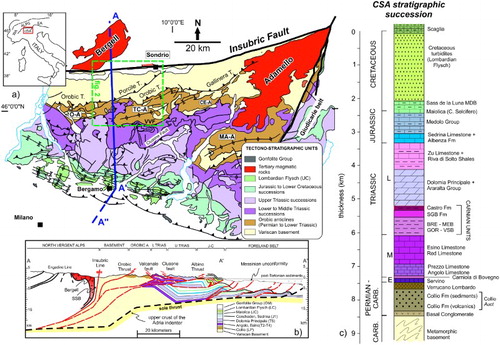
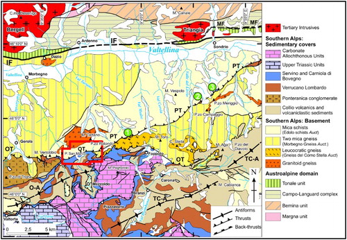
Figure 2. Detailed tectonic scheme of the central Southern Alps in the area surrounding the San Marco pass. Redrawn after CitationCasati and Gnaccolini (1967) and CitationForcella and Jadoul (2000). IF: Insubric Fault; O-A: Orobic Anticline; OT: Orobic Thrust; PT: Porcile Thrust; TC-A: Trabuchello-Cabianca Anticline. The extent of the geological-structural Main Map is highlighted in red. Numbered green circles are sites of structural analyses: data are reported in .
Structural analyses and fault rock dating (CitationMeier, 2003; CitationZanchetta et al., 2011, Citation2013) highlighted a polyphase history of such regional thrusts. They initially formed during the Late Cretaceous, in the hangingwall of the Tethyan subduction; they were later re-activated in Late Palaeocene to Middle Eocene during the ongoing Africa-Europe collision and, finally, accommodated in the cSA the dextral transpression of the Insubric Fault during the Oligocene (CitationSchmid, Aebli, Heller, & Zingg, 1989).
In several sectors of the cSA (CitationAlbini et al., 1994; CitationCarminati & Siletto, 2005) good exposures of these regional structures allow to reconstruct fault zone evolution, the relationships among different faults, and the associated deformation structures in the footwall and hangingwall blocks.
In the San Marco pass area (Lombardy, N Italy) the E-W trending Orobic Thrust ( and ) stacks the cSA basement on the Permian and Lower Triassic sedimentary cover (CitationSiletto, 1990, Citation1991). To the E of the pass ( and Main Map) the Orobic Thrust joins the Porcile Thrust, an ENE-WSW trending intra-basement shear zone along which tectonic slices of Permian and Lower Triassic sediments are preserved.
We mapped the area that comprises the junction of these two major faults in order to understand their geometrical and kinematic relationships, to identify sites for detailed structural analyses and collect samples for fault rock characterization and dating.
For a more detailed discussion of structural analyses, fault kinematics and evolution, and dating of tectonic pseudotachylytes, the readers are referred to CitationD'Adda (2010) and CitationZanchetta et al. (2011).
The geological-structural Main Map has been realized by original field mapping at 1:5000 scale and then reduced to 1:10,000 for map publication. The extent of the mapped area is about 12 km2.
Existing maps comprising the same area and adjacent ones are the Sheet 056 ‘Sondrio’ (CitationBoriani & Bini, 2012) of the new Geologica Map of Italy at 1:50,000 scale and the 1:25,000 scale map by CitationCasati and Gnaccolini (1967).
2. Geological setting and lithostratigraphy
The Orobic Thrust truncates the Porcile fault 2 km WNW of Cima dei Siltri (and ). West of this point, the Orobic Thrust trends roughly E–W and it stacks mica schists and gneisses on the Servino and the Upper Permian red conglomerates of Verrucano Lombardo ().
Figure 3. Panoramic view of the Orobic Thrust toward Passo Verrobbio, from Rifugio San Marco 2000. Mcs: mica schists; PNT: Ponteranica Conglomerates; SERV: Servino; VER: Verrucano Lombardo.
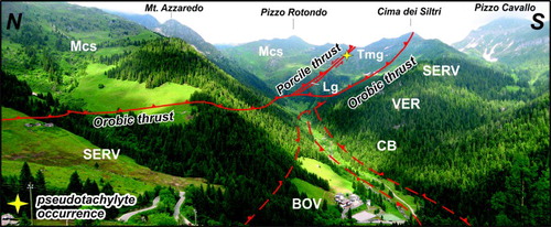
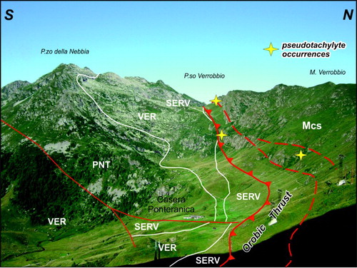
Figure 4. The Orobic-Porcile thrusts junction between Monte Azzaredo and Cima dei Siltri. The yellow star mark the occurence of pseudotachylyes along the fault zone. BOV: Carniola di Bovegno; CB: Monte Cabianca Volcanites; Mcs: mica schists; Lg: leucocratic gneiss; SERV: Servino; Tmg: two-mica gneiss; VER: Verrucano Lombardo. Arrows along the Porcile thrust indicate the late-stage sinistral transpression.
The Porcile Thrust, a high-angle reverse fault a NNW dip of ca. 60°, shows an ENE-WSW trend across the southern slopes of Valtellina. The basement unit sandwiched between these two faults consists of biotite – white mica gneisses and mica schists, with minor leucocratic gneisses, K-feldspar orthogneiss and amphibolite lenses. A distinctive feature of the Porcile Thrust is the occurrence, along the fault zone, of tectonic slices derived from Servino and Verrucano Lombardo, locally associated with thin layers (up to 7–8 m) of Carniola di Bovegno. This rocks association repeatedly occurs also E of the study zone, within tectonic slices pinched along the Gallinera Thrust () which is the eastern continuation of the Orobic Thrust.
2.1. The Variscan crystalline basement
The basement of the cSA consists of gneiss and mica schists, with minor amphibolites and metaintrusive rocks (CitationBoriani & Bini, 2012; CitationGosso et al., 2012). Several tectonometamorphic units have been distinguished chiefly on the base of their pre-Alpine evolution (CitationDi Paola et al., 2001; CitationSpalla & Gosso, 1999; CitationSpalla, Siletto, di Paola, & Gosso, 2000). Alpine metamorphism was weak and generally produced no pervasive re-crystallization of the Variscan phase assemblages. Structural analyses and metamorphic petrology highlighted the occurrence of at least two pre-Alpine syn-metamorphic phases, followed by other two compressional phase of Alpine age (CitationAlbini et al., 1994; CitationCadel, Cosi, Pennacchioni, & Spalla, 1996; CitationCarminati & Siletto, 2005; CitationMilano, Pennacchioni, & Spalla, 1988; CitationSiletto, 1991; CitationSpalla & Gosso, 1999).
2.1.1. Mica schists (Scisti di Edolo Auct.)
Mica schists represent the most widespread lithology in the map area. They are fine-grained and appear gray to dark-gray in outcrops. The mineralogy consists of white mica, quartz, biotite and plagioclase. Chloritized garnet and staurolite porphyroblasts partly substituted by sericitic aggregates have been seldom observed in the field. Apatite, tourmaline and zircon occur as accessory phases, together with various oxides. A few centimeters thick quartzite levels and quartz lenses are frequently abundant within the mica schists.
2.1.2. Two-mica gneiss
Two-mica gneiss occurs in a limited sector of the study area, north of Cima dei Siltri (Main Map), in the tectonic slice comprised between the Orobic and Porcile thrusts. It is a medium-grained paragneiss with quartz, plagioclase, biotite, muscovite and minor garnet and chlorite. It alternates with mica schists and displays transitional contacts with them. Quartz lenses and quartzitic layers are generally absent.
2.1.3. Leucocratic gneiss (Gneiss Chiari del Corno Stella Auct.)
Leucocratic gneisses form elongated lenses along the Porcile fault zone and occur along a secondary splay of the Orobic Thrust, NE of Cima dei Siltri (Main Map). They are medium to coarse-grained orthogneiss, white to light gray in outcrop, with a typical mineralogy made of quartz, albite, plagioclase, muscovite, biotite, minor chlorite and rare crystals of tourmaline. The textural characters of these rocks are almost completely overprinted by the thrust-related cataclastic deformation.
2.1.4. Granitoid gneiss (Ortogneiss del Monte Fioraro Auct.)
Medium- to coarse-grained granitoid gneisses crop out in the NW sector of the map (Main Map). They derive from intrusive bodies of Ordovician age, later metamorphosed and strongly deformed during the Varisican orogeny (CitationBoriani & Bini, 2012). They display an ‘augengneiss’ texture with eye-shaped K-feldspar porphyroclasts up to 2–3 cm in size. The gneiss consists of K-feldspar, quartz, plagioclase, muscovite, biotite, with minor garnet, titanite and chlorite.
2.1.5. Amphibolites
In the study area, amphibolites occur only as a single lense, about 2-meters wide and 10 meters long, north of Cima dei Siltri (Main Map). Amphibolites consist of amphibole, plagioclase, quartz and minor garnet, biotite and chlorite.
2.1.6. Pre-Alpine dikes
In the NW sector of the Main Map, along the margins of the Mt. Fioraro metagranidoid complex, several lenses of gray to dark-green rocks with a faintly preserved porphyritic texture occur within the granitoid gneiss. They roughly trend E-W, with sharp contacts with country rocks and are deformed by D3 folds of Alpine age (see below for details). They are dark colored, very fine-grained, with plagioclase, biotite, amphibole and minor quartz. A poorly developed foliation defined by the shape-preferred orientation of biotite and amphibole has been rarely observed. On the base of these observations, we interpret these rocks as post-Variscan intrusive dikes of basaltic to andesitic composition, already recognized in other parts of the cSA (CitationCadel et al., 1996).
2.2. The Permian-Lower Triassic sedimentary cover
In the study area the sedimentary cover of the cSA spans in age from the possibly Upper Carboniferous strata of the Basal Conglomerates, to the Anisian limestones and dolostones of the Carniola di Bovegno (CitationForcella & Jadoul, 2000; CitationGosso et al., 2012, for a summary of the cSA sedimentary cover stratigraphy in the study area).
2.2.1. Basal Conglomerate (Upper Carboniferous? – Lower Permian)
These dark green to gray breccias and sandstones were derived from the erosion of the metamorphic basement of the central Southern Alps. They crop out in the southeastern sector of the map, north of San Simone pass (Map). Clasts are up to some centimeters in size and comprise quarzites, metapelites and minor metagranitoid gneisses. The original bedding is not recognizable in the area since a N-dipping cataclastic foliation, related to the activity of the Orobic thrust, strongly overprints the original texture.
2.2.2. Monte Cabianca Volcanite (Lower Permian)
Red to brown volcanic and volcaniclastic deposits, alternating with minor sandstones and siltstones are the main lithologies forming this unit. Within the mapped area they crop out only in a small sector, east of Rifugio Madonna delle Nevi. They are the stratigraphically lowest part of a volcanic and volcaniclastic formation of Early Permian age, known in the literature as ‘Collio Formation’ (see CitationGosso et al., 2012 for references). They are the result of a widespread calcalkaline magmatism occurred during transtensional tectonics that led to the opening of fault-controlled troughs filled by continental deposits (CitationOrigoni-Giobbi, Peyronel Pagliani, & Zanchini Camerini, 1979).
2.2.3. Verrucano Lombardo (Upper Permian)
This formation consists of red to brown, fluvial continental conglomerates and breccias with lenses of red sandstones and pelites. Clasts are millimetric to centimetric and consist of quartz, red volcanites and volcanoclastites and minor metapelites. The unit crops out in the southeastern area of the Main Map. East of Rifugio Madonna delle Nevi the stratigraphic contact with the Cabianca Volcanite unit is partially preserved and little deformed. In contrast, north of the San Simone pass the unit is involved in high-angle fault systems related to thrusting along the Orobic thrust.
2.2.4. Servino (Induan-Olenekian)
Well-bedded quartz sandstones with green to light green pelites and minor yellow to green marls mainly compose this unit. It crops out in the southern sector of the map, in the footwall of the Orobic thrust. Bedding is often deformed by E-W trending folds, and cataclastic layers are common near the tectonic boundary with the overthrust metamorphic basement.
2.2.5. Carniola di Bovegno (Olenekian-Anisian)
The Carniola di Bovegno consists of yellow vacuolar dolomitic limestones and dolostones with lenses of gray to green marls and clay. Lenses of Carniola di Bovegno are usually localized along tectonic contacts and are affected by a N-dipping cataclastic foliation. In the southern sector of the Main Map the occurrence of carniòules within the Servino are indicative of tectonic repetitions with a southward direction of transport.
3. Structure
The metamorphic basement exposed in the Main Map area displays a polyphase history (CitationAlbini et al., 1994; CitationCarminati & Siletto, 2005; CitationCarminati, Siletto, & Battaglia, 1997; CitationSpalla, Carminati, Ceriani, Oliva, & Battaglia, 1999; CitationSpalla & Gosso, 1999). The oldest structural relics (D1) are chiefly preserved within quartz-rich lithologies and granitoid gneisses, whereas they have been seldom observed in mica schists and paragneiss. When visible, the shape-preferred orientation of biotite and minor white mica defines the S1 foliation in mica schists. Syn-D1 phase assemblages within metapelites contain garnet and staurolite, suggesting amphibolite facies conditions during the D1 event (CitationCadel et al., 1996; CitationCarminati & Siletto, 2005; CitationSpalla et al., 1999).
Greenschist facies metamorphism accompanied the D2 deformation event. Isoclinal folds with an associated S2 axial plane foliation are the distinctive fabric elements produced by this deformation phase. The D2 folds clearly affect and deform (CitationSiletto, 1990, Citation1991) the contacts between granitoid gneisses of Ordovician age (CitationBoriani & Bini, 2012) and the hosting metapelitic-metapsammitic basement, suggesting a Variscan age for both D1 and D2 deformation phases and associated metamorphism.
North of San Marco Pass the S2 regional foliation if folded around N- to NW-dipping fold axes () in open to medium-tight folds (D3a). Within mica-rich rocks a centimeter-scale crenulation develops (). No axial plane foliation is associated with the D3a folds. To the E of the Orobic and Porcile thrusts junction D3a fold axes gently rotate and plunge eastward (), becoming sub-parallel to the folds in the sedimentary cover. The relationships between D3a structures and the early stage of thrusting are visible along the road S of San Marco Pass. Approaching the fault zone, folds in the basement become increasingly tight and fold axes progressively rotate becoming parallel to the E-W trending greenschist mylonitic foliation that characterize the hangingwall sector of the fault zone. Re-orientation of D3a folds and their original N-S to NW-SE trending axes suggests that they are unrelated to the early stage of fault activity along the Orobic Thrust, but likely predate it.
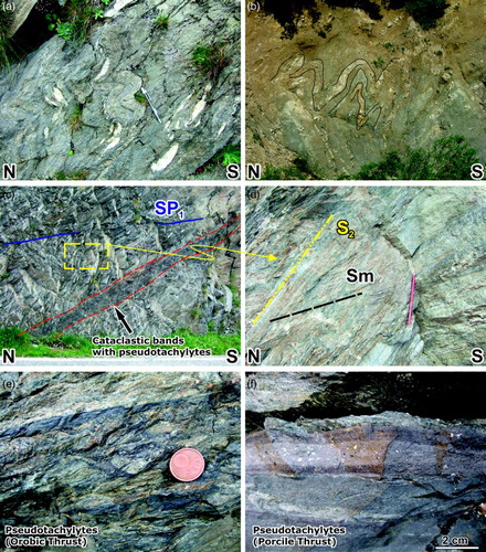
Figure 5. (a) Alpine folds in the micaschists, W of Stalla Bressano; (b) a strongly deformed slices of Servino with S-verging D3 folds, Pra del Muto; (c) the upper part of the Orobic Thrust fault zone, along the road ca. 500 m S of Passo San Marco; (d) detail of image (c), the mylonitic foliation crosscuts the regional S2 foliation in mica schists; (e) pseudotachylyte veins within cataclasites, Orobic Thrust, first hairpin turn S of Pass San Marco; and (f) a thick pseudotachylyte vein laden with clasts of quartz and plagioclase, ridge between Cima dei Siltri e Pizzo Rotondo.
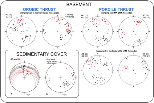
Figure 6. Sketch of the crosscutting relationships among the S2 foliation, mylonites, pseudotachylyte veins and later brittle structure.
The Orobic Thrust fault zone displays a complex architecture related to its polyphase evolution (see CitationD'Adda, 2010; CitationZanchetta et al., 2011 for details). The N- to NNW-dipping mylonitic foliation is overprinted by pseudotachylyte-bearing cataclastic shear zones and brittle shear planes (). Along the Porcile Thrust the greenschist facies mylonites display higher dip angles with respect to the Orobic Thrust mylonites (), The mylonitic foliation dips NW, following the regional orientation of the fault zones. Similar to what occurs in the Orobic Thrust fault zone also the Porcile mylonites are overprinted by cataclastic deformation associated with the generation of pseudotachylytes that indicates how fault evolution passed through a period of seismic activity. The Porcile joins the Orobic Thrust NW of Cima dei Siltri and does not continues southward. Close to the junction point, several lenses of leucocratic gneiss are pinched within the Porcile fault zone. Measured fault planes dip NNW, with a 10° to 15° clockwise rotation with respect to mylonites. Kinematic indicators along the brittle fault zone point to a mainly dip-slip motion, with a reverse sense of shear accompanied by a minor left-lateral component ().
Figure 7. Stereographic projections (equal area, lower hemisphere) of structures related to the D2 and D3 deformation phase. Discrete reverse shear planes that postdate major thrusting occur both in the sedimentary cover and within the fault zone (see ).
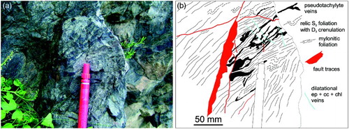
Figure 8. Stereographic projections (equal area, lower hemisphere) of fault slip data set for the Orobic (a) and Porcile and (b) thrust.
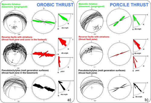
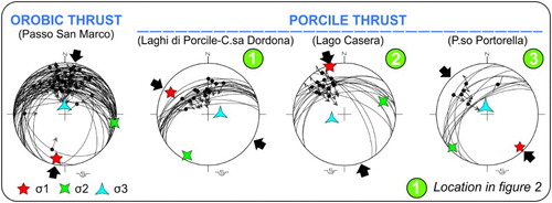
Inversion of fault data measured along the Orobic and Porcile thrusts () shows how compression was oriented roughly N-S along the Orobic Thrust and roughly NW-SE along the Porcile Thrust. The different shortening direction shown by the Porcile line is likely due to its orientation with respect to the about N-S-directed stress existing in the cSA during the early stages of Alpine deformation (CitationZanchetta et al., 2013). The occurrence of tectonic slices of Verrucano Lombardo, Servino and Carniola di Bovegno along the Porcile fault zone, together with its NE-SW orientation, suggest that it likely originated from the inversion of pre-existing regional structures, such as the normal fault of Permian age (CitationFroitzheim, Derks, Walter, & Sciunnach, 2008) that bordered the Collio basins.
Figure 9. Regional stress obtained by inversion of fault slip data (CitationAngelier, 1990). Location of measurement sites is reported in .
Reconstructions of the original shape of the Collio basin (CitationBlom & Passchier, 1997; CitationCadel et al., 1996; CitationSchönborn, 1992) proposed it was roughly oriented NE-SW to ENE-WSW, i.e. sub-parallel to the present day direction of the Porcile Thrust.
The steeper dip angles of both mylonites and reverse faults along the Porcile Thrust with respect to the Orobic Thrust, suggest that it was possibly rotated after the major thrusting phase (CitationCarminati & Siletto, 2005). Present day dip angles appear in fact far too steep for a thrust. When the Porcile Thrust reached fault lock-up angle no further thrusting occurred along it and the shortening was accommodated along the Orobic Thrust both W and E (CitationCasati & Gnaccolini, 1967) of the junction point, as suggested also from radiometric ages obtained from fault rocks (CitationZanchetta et al., 2011).
An alternative hypothesis is that the Porcile Thrust was already steep prior to Alpine shortening, retaining the original high angle of normal faults that controlled the evolution of the Collio basin. In this case, the Porcile Thrust was re-activated as a reverse fault, but, due to its high-angle dip, non significant shortening could be accommodated along it and, after the initial phase, southward thrusting occurred preferentially along the Orobic Thrust.
The Permian to Lower Triassic succession in the footwall of the Orobic thrust shows open to medium-tight E-W trending folds with a meter-scale wavelength, well developed in the terrigenous succession of Servino (). Axial plane cleavage is frequently associated with folds, especially in fine-grained sandstones and siltstones. Fold axial planes and cleavage dip N to NW with dip angles ranging between 40° and 55° (). The attitudes of folds and cleavage, together with their geometrical relationships, suggest that they formed in response of southward thrusting of the basement along the Orobic Thrust. We relate these structures to a possibly different deformation event, namely D3b, from the one that produced the N-plunging fold in the basement.
The last deformation phase recognized along the Orobic and Porcile thrusts is a strike-slip to dextral transpressive re-activation of major faults (). Reverse left-lateral structures are recognized only along the Porcile Thrust, close to the junction with the Orobic Thrusts. These are likely related to the last phase of shortening accommodated by the Orobic Thrust, when the Porcile fault zone was already too steep to be re-activated with a pure dip-slip component.
Figure 10. Oligocene (?) re-activation of fault zones in response of the dextral transpressive activity of the Insubric Fault.
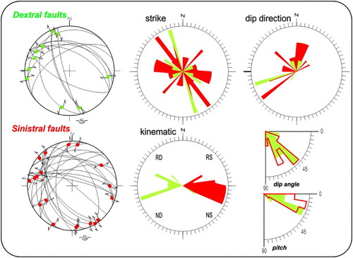
The reverse right-lateral faults measured along the Orobic Thrust crosscut all previous structure; we tentatively relate this tectonic phase, which took place at shallow crustal level, to the well-documented dextral transpressive activity of the Insubric Fault during the Oligocene (CitationSchmid et al., 1989).
4. Conclusions
The geological structural map of the San Marco Pass area and the structural data collected during field work allow constraining the geometrical and kinematic relationships between the Orobic and Porcile thrusts, two major regional structures of the central Southern Alps. Field structural analyses have shown that the earliest Alpine folding phase in the basement possibly predates the formation of mylonites along the Orobic and Porcile thrusts. The development of ductile shear zones along the two thrusts is consistent with folding and cleavage formation in the Permian and Triassic cover in the footwall. The transition from ductile (mylonites + folding in the cover) to brittle deformation (faulting and pseudotachylyte formation) along the Orobic and Porcile thrusts resulted in a strong cataclastic overprint on existing fabrics, associated with friction-induced melting of fault rocks and the formation of pseudotachylytes.
The steep dip of mylonites and reverse faults along the Porcile Thrust suggest that it was progressively rotated during and/or after the major thrusting phases, until it was too steep to sustain further shortening as later compressive deformation was accommodated by the Orobic Thrust.
The observed transpressive re-activation of the Orobic Thrust likely occurred in response of the dextral transpression that characterizes the main activity phase of the Insubric Fault.
Software
Original paper-supported field maps at 1:5000 scale were rasterized and georeferenced with ArcView version 10.0 (ESRI Inc.). Location of samples and structural data were registered as GPS coordinates with a handle GPS device (Garmin Trek cVista) and then imported in ArcView as .gpx files.
The Main Map was then digitalized in ArcView at 1:1000 to 1:2000 scale, integrating field data with aerial photographs and DTM (20 × 20 m resolution) of Regione Lombardia.
The final layout was realized with CorelDraw (v. 15.0), after importing digitalized map data from ArcView.
Stereographic projections of structural data (foliation, fold elements and lineation) have been realized with OpenStereo (Grohmann, C.H. and Campanha, G.A.C., 2010. OpenStereo: open source, cross-platform software for structural geology analysis. Presented at the AGU 2010 Fall Meeting, San Francisco, CA.). Fault slip data sets have been projected with the software of CitationAngelier (1984).
The paleo regional stress has been calculated through the inversion of fault slip data through the direct inversion method of CitationAngelier (1990).
Main Map: Geological-Structural Map of the Orobic and Porcile Thrust Junction, Central Southern Alps (In Italy)
Download PDF (4.9 MB)Acknowledgements
Financial support for field work and analyses were from the Doctoral School of Sciences of the University of Milano Bicocca and from FAR of A. Zanchi. We warmly thank A. Zanchi also for thoughtful discussions on the tectonic evolution of the Southern Alps and for suggestions on an early version of the paper. Constructive reviews by Eugenio Carminati and Niko Froitzheim helped the authors to better clarify some geological aspects of the work. The final version of the geological map greatly benefited from suggestions and observations by Chris Orton.
Related Research Data
References
- Albini, S., Battaglia, D., Bellini, G., Bigoni, E., Carminati, E., Ceriani, S., … Spalla, M. I. (1994). Alpine deformations and pre-Alpine remnants in the north-eastern Orobic Alps, Southalpine basement. In A. Montrasio & E. Sciesa (Eds.), Proceedings of Symposium “CROP-Alpi Centrali”, Quaderni di Geodinamica Alpina e Quaternaria', pp. 25–39.
- Angelier, J. (1984). Tectonic analysis of fault slip data sets. Journal of Geophysical Research, 89, 5835–5848. doi: 10.1029/JB089iB07p05835
- Angelier, J. (1990). Inversion of field data in fault tectonics to obtain the regional stress-III. A new rapid direct inversion method by analytical means. Geophysical Journal International, 103, 363–376. doi: 10.1111/j.1365-246X.1990.tb01777.x
- Berra, F., & Siletto, G. B. (2006). Controllo litologico e stratigrafico sull'assetto strutturale delle Alpi meridionali lombarde: Il ruolo degli orizzonti di scollamento. Rendiconti della Società Geologica Italiana, 2, 78–80.
- Blom, J. C., & Passchier, C. W. (1997). Structures along the Orobic thrust, Central Orobic Alps, Italy. Geologische Rundschau, 86, 627–636. doi: 10.1007/s005310050168
- Boriani, A., & Bini, A. (2012). Note Illustrative della Carta Geologica d'Italia alla scala 1:50.000 - foglio 056 ‘SONDRIO’, I.S.P.R.A. and Regione Lombardia.
- Cadel, G., Cosi, M., Pennacchioni, G., & Spalla, M. I. (1996). A new map of the Permo-Carboniferous cover and Variscan metamorphic basement in the Central Orobic Alps, Southern Alps–Italy. Memorie di Scienze Geologiche, i, 1–53.
- Carminati, E., & Siletto, G. B. (2005). The Central Southern Alps (N. Italy) paleoseismic zone: A comparison between field observations and predictions of fault mechanics. Tectonophysics, 401, 179–197. doi: 10.1016/j.tecto.2005.03.012
- Carminati, E., Siletto, G. B., & Battaglia, D. (1997). Thrust kinematics and internal deformation in basement involved foreland fold and thrust belt: The Eastern Orobic Alps case (Central Southern Alps, Northern Italy). Tectonics, 16, 259–271. doi: 10.1029/96TC03936
- Casati, P., & Gnaccolini, M. (1967). Geologia delle Alpi Orobie Occidentali. Rivista Italiana di Paleontologia e Stratigrafia, 73, 25–162.
- D'Adda, P. (2010). Eo-alpine evolution of the central Southern Alps: Insights from structural analysis and new geochronological constraints, PhD thesis, University of Milano Bicocca.
- D'Adda, P., Zanchi, A., Bergomi, M., Berra, F., Malusà, M. G., Tunesi, A., & Zanchetta, S. (2011). Polyphase thrusting and dyke emplacement in the central Southern Alps (Northern Italy). International Journal of Earth Sciences, 100, 1095–1113. doi: 10.1007/s00531-010-0586-2
- Di Paola, S., Spalla M. I., & Gosso G. (2001). New structural mapping and metamorphic evolution of the Domaso Cortafo' Zone (Southern Alps–Lake Como). Memorie di Scienze Geologiche, Padova, 53, 1–14.
- Doglioni, C., & Bosellini, A. (1987). Eoalpine and mesoalpine tectonics in the Southern Alps. Geologische Rundschau, 76, 735–754. doi: 10.1007/BF01821061
- Forcella, F., & Jadoul, F. (2000). Carta Geologica della Provincia di Bergamo a scala 1:50.000 Geological Map of the Bergamo Province, scale 1:50.000. Bergamo: Grafica Monti.
- Froitzheim, N., Derks, J. F., Walter, J. M., & Sciunnach, D. (2008). Evolution of an early Permian exextension detachment fault from synintrusive, mylonitic flow to brittle faulting (Grassi Detachment Fault, Orobic Anticline, southern Alps, Italy). Geological Society, London, Special Publications, 298, 69–82. doi: 10.1144/SP298.4
- Gosso, G., Spalla, M. I., Bini, A., Siletto, G. B., Berra, F., & Forcella, F. (2012). Note Illustrative della Carta Geologica d'Italia alla scala 1:50.000 - foglio 057 ‘MALONNO’, I.S.P.R.A. and Regione Lombardia.
- Laubscher, H. P. (1985). Large scale, thin-skinned thrusting in the Southern Alps: Kinematic models. Geological Society of America Bulletin, 96, 710–718. doi: 10.1130/0016-7606(1985)96<710:LTTITS>2.0.CO;2
- Meier, A. (2003). The Periadriatic Fault System in Valtellina (N-Italy) and the evolution of the Southwestern segment of the Eastern Alps, PhD thesis, ETH, Zürich.
- Milano, P. F., Pennacchioni, G., & Spalla, M. I. (1988). Alpine and pre-Alpine tectonics in the Central Orobic Alps (Southern Alps). Eclogae Geologicae Helvetiae, 81, 273–293.
- Origoni-Giobbi, E., Peyronel Pagliani, G., & Zanchini Camerini, R. (1979). Contributo alla conoscenza chimico-petrografica delle vulcaniti permiane affioranti tra la Val Trompia e le Valli Giudicarie. Rendiconti della Società Italiana di Mineralogia e Petrografia, 35, 277–298.
- Schmid, S., Aebli, H. R., Heller, F., & Zingg, A. (1989). The role of the Periadriatic Line in the tectonic evolution of the Alps. Geological Society, London, Special Publication, 45, 153–171. doi: 10.1144/GSL.SP.1989.045.01.08
- Schönborn, G. (1992). Alpine tectonics and kinematic models of the central Southern Alps. Memorie di Scienze Geologiche, 44, 229–393.
- Siletto, G. B. (1990). Polyphase tectonics in the Orobic basement of Passo S. Marco (Upper Val Brembana, Southern Alps, Italy). Memorie della Società Geologica Italiana, 45, 101–105.
- Siletto, G. B. (1991). Cronologia relativa dei sovrascorrimenti in aree selezionate del basamento Orobico, PhD thesis, Department of Earth Sciences, University of Milano.
- Spalla, M. I., Carminati, E., Ceriani, S., Oliva, A., & Battaglia, D. (1999). Influence of deformation partitioning and metamorphic re-equilibration on P-T path reconstruction in the pre-Alpine basement of Central Southern Alps (Northern Italy). Journal of Metamorphic Geology, 17, 319–336. doi: 10.1046/j.1525-1314.1999.00199.x
- Spalla, M. I., & Gosso, G. (1999). Pre-Alpine tectonometamorphic units in the central Southern Alps: Structural and metamorphic memory. Memorie di Scienze Geologiche, 51, 221–229.
- Spalla, M. I., Siletto, G. B., di Paola, S., & Gosso, G. (2000). The role of structural and metamorphic memory in the distinction of tectono-metamorphic units: The basement of the Como lake in the Southern Alps. Journal of Geodynamics, 30, 191–204. doi: 10.1016/S0264-3707(99)00033-2
- Zanchetta, S., D'Adda, P., Zanchi, A., Barberini, V., & Villa, I. M. (2011). Cretaceous-Eocene compressions in the central Southern Alps (N Italy) inferred from 40Ar/39Ar dating of pseudotachylytes along regional thrust faults. Journal of Geodynamics, 51, 245–263. doi: 10.1016/j.jog.2010.09.004
- Zanchetta, S., Malusà, M. G., & Zanchi, A. (2013). Pre-collisional development and Cenozoic evolution of the central Southern Alps (N Italy). Rendiconti Online della Società Geologica Italiana, 29, 194–197.