
Abstract
We present a 1:10,000 scale geological map for the south-eastern sector of the Volterra Basin (Northern Apennines, Italy), together with supporting stratigraphic-structural data. The Volterra Basin consists of a major structural depression within the Northern Apennines hinterland, NNW-SSE-oriented and filled with more than 2000 m of late Miocene-Quaternary deposits. Its south-eastern sector is classically considered as a type area for late Tortonian non-marine strata, here mapped and refined in terms of internal stratigraphy adopting a scheme of depositional and lithostratigraphic units. Stratigraphic assessments helped in redefining the character of the lower boundary of the non-marine succession, as well as in mapping a newly recognized angular unconformity. Deformation structures affecting the basin fill include blind normal faults rooted to a deep detachment, outcrop-scale transtensional faults and clusters of gentle folds. Faults and folds appear to be kinematically linked. Our structural observations largely agree with those present in the literature, supporting a model of post-orogenic crustal stretching.
1. Introduction
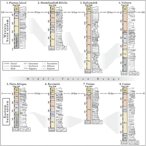
Along its coastal and central sectors, Tuscany (Northern Apennines, Italy) is featured by a set of hinterland sedimentary basins (a; CitationMartini & Sagri, 1993), the evolution of which can be traced back from the middle-late Miocene to recent times (CitationBossio et al., 1998; CitationCornamusini et al., 2011). Inland basins and offshore correlatives cover an area of more than 20,000 km2 (b), and have either been interpreted as post-orogenic/syn-rift (CitationCarmignani et al., 1994) or thrust-top (CitationBoccaletti, Bonini, Moratti, & Sani, 1999). Strong similarities are apparent in the fill of different basins throughout the hinterland, with, from the oldest (d and 2; CitationBossio et al., 1998; CitationPascucci, Merlini, & Martini, 1999): Burdigalian-Tortonian marine facies; Tortonian non-marine to lagoon facies; Messinian marine to brackish-evaporitic facies; Pliocene-Pleistocene marine to non-marine facies. Late Miocene successions are traced over an area of some 150 × 140 km (CitationCarmignani, Conti, Cornamusini, & Pirro, 2013), with type sections reported from the literature shown in . The Neogene palaeogeography of Tuscany was controlled by fluctuating sea level and differential tectonic uplift and subsidence (CitationBossio et al., 1998). Since the late Tortonian-Messinian, a major feature in the hinterland consists of the Middle Tuscan Range, a structural-morphologic high the uplift of which contributed in differentiating the stratigraphy of an eastern and a western basin system (CitationBossio, Mazzei, Salvatorini, & Sandrelli, 2002; CitationCarmignani et al., 2013; ; CitationCostantini et al., 2009).
Figure 1. Geographic and geological background of the Volterra Basin. (a) Geographic location of Tuscany, Northern Apennines, Italy, and distribution of the late Miocene deposits (gray) in the Northern Apennines hinterland and northern Tyrrhenian Sea. Black/white crossed spots indicate the location of boreholes that encountered/did not encounter Miocene facies (data in part from CitationGhelardoni et al., 1968). Mc: eastern limit of Miocene hinterland facies; MTR: Middle Tuscan Range; numbers 1–8: approximate location of the type sections in . (b) Simplified geological sketch of the study area, with depositional units and main structural features reported. (c) Chronostratigraphic framework adopted in this study, from CitationIelpi (2013).
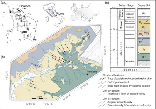
Figure 2. Schematic type sections of the late Miocene successions of the Tuscan hinterland and northern Tyrrhenian Sea, with Tortonian non-marine tracts (shaded in light gray) occurring in most basins. Locations for the sections are reported in a. Age of depositional units is as follows: late Serravallian - early Tortonian (st1), early - middle (?)/late Tortonian (tt1), middle (?)/late Tortonian (tt2), early Messinian (ms1), early - middle (?) late Messinian (ms2–3), and Zanclean (pl1). Data in part from: CitationCornamusini et al. (2014), section 1; CitationLazzarotto and Mazzanti (1976), CitationBossio et al. (1994, Citation1996, Citation1998), CitationForesi et al. (1997, Citation2000, Citation2003), CitationCostantini et al. (2002, Citation2009), CitationLazzarotto et al. (2002), and CitationIelpi (2013), sections 2–4; CitationBossio et al. (2004) and CitationCornamusini et al. (2011), section 5; CitationBenvenuti et al. (2001), CitationRook and Ghetti (1997), and CitationRook, Oms, Benvenuti, and Papini (2011), sections 6–7; CitationBossio et al. (2002), section 8.
The Volterra Basin, the subject of this study, belongs to the western basin system, and has been long considered a type location for the late Miocene of the Northern Apennines hinterland (CitationBossio, Cerri, Mazzei, Salvatorini, & Sandrelli, 1994; CitationBossio, Cerri, Mazzei, Salvatorini, & Sandrelli, 1996). The Basin consists of a major structural depression, NNW-SSE-oriented and filled with more than 2 km of deposits (d) that recorded diverse marine and non-marine stages, and yield among others a remarkable insight on the Messinian salinity crisis of the Mediterranean Sea (CitationHsü et al., 1977; CitationKrijgsman, Hilgen, Raffi, Sierro, & Wilson, 1999; CitationTesta & Lugli, 2000). The oldest non-marine portion of the basin fill is dated to the Tortonian (CitationBossio et al., 1996), its best exposure occurring along a south-eastern, SW-NE-trending belt of some 10 × 5 km in size (b).
Despite ongoing interest in Messinian-Zanclean strata of the Volterra Basin (CitationCarnevale, Longinelli, Caputo, Barbieri, & Landini, 2008; CitationRiforgiato et al., 2011), the underlying non-marine tract has largely been ignored over the last 20 years. Only recently has the depositional evolution and palaeogeography of the non-marine facies proved to be more articulated than previously thought (CitationIelpi & Cornamusini, 2012; CitationIelpi, 2013). A greater amount of basic geological information is now required for expanding upon the scientific debate on this crucial sector of the Northern Apennines. The main scope of this research is to address this deficiency, by introducing an original geological map focused on the non-marine deposits, the Main Map attached to this paper. Mapping at 1:10,000 scale was supported by stratigraphic and structural assessments on the basin fill. Our results introduce an improved stratigraphic scheme for the late Miocene succession and, through detailed geological mapping, document for the first time a previously ignored basin-scale surface of angular unconformity within the non-marine deposits. In its broader perspective, this work is intended to contribute to the general understanding of Neogene sedimentation in the Northern Apennines.
2. Methods
The south-eastern Volterra Basin is located approximately between 43° 24′ N - 11° 00′ E and 43° 21N′ - 10° 54′ E (b). The study area is located some 7 km to the south-east of the Etruscan town of Volterra, comprises the hamlet of Ponsano, and was mapped between September 2011 and August 2013. Field mapping was performed using a vector topographic-base map derived from the ‘Ponsano’ sheet (Ref. #295040), zoomed to 1:5000 scale in the field and then reported to the original 1:10,000 scale. Stratigraphic methods included sedimentologic analysis and bed-by-bed logging of natural exposures spaced 250–1000 m apart (the sedimentologic details of which are reported in CitationIelpi & Cornamusini, 2012; CitationIelpi, 2013). Prominent stratigraphic surfaces were walked directly in the field and traced in between logs.
The adopted stratigraphic scheme follows a subdivision in depositional and lithostratigraphic units (). Following previous literature, depositional units are hybrid stratigraphic units defining packages of strata broadly sharing age, sedimentology and palaeo-environmental setting (CitationBossio et al., 1998, Citation2004). Their adoption is purely pragmatic, and best fits with the stratigraphic complexity of the Northern Apennines post-orogenic hinterland. Depositional units are either bounded by basin-margin unconformities or basin-centre correlation conformities (CitationIelpi & Cornamusini, 2012), and in some cases correspond de facto to unconformity-bounded stratigraphic units (sensu CitationSalvador, 1987). Depositional units were named with two lower case letters abbreviating their age, a subscript progressive number (e.g., st1 for the oldest depositional unit, Serravallian-Tortonian in age), and are composed of informal lithostratigraphic units, coded with three-letter acronyms on the map. The latter lithostratigraphic units were named following CitationIelpi and Cornamusini (2012) and earlier literature, in order to avoid redundancy in stratigraphic nomenclature. Structural methods consisted in the evaluation of regional strike, dip and styles of deformation structures; assessment of displacement and geometry of faults and folding structures; and measurement of degree of angularity across surfaces of unconformity.
Figure 3. Comparative stratigraphic frameworks for the non-marine facies of the south-eastern Volterra Basin (highlighted in gray). The relative positions of the stratigraphic units and boundaries derive from geometric relationships, and do not represent time lines. The framework adopted in this research follows the schemes of CitationIelpi and Cornamusini (2012) and CitationIelpi (2013).
3. Stratigraphy
The stratigraphy of the study area comprises, from the bottom, an uprooted, deformed bedrock (coded bdr on the map) of early Cretaceous shale and limestone bearing ophiolite blocks (‘Palombini’ Shales, belonging to the Inner Ligurian Domain; CitationBertini, Cornamusini, Lazzarotto, & Maccantelli, 2000). Bedrock is overlain by middle-late Miocene to Quaternary deposits. In partial revision of the previous literature (CitationBossio et al., 1994, Citation1996, Citation1998), several depositional units have been recognized in the study area (c), spanning from late Serravallian to Pleistocene in age and covered in places by Holocene evolving deposits related to phenomena of slope degradation and alluvium. Depositional units are here described from the bottom and oldest, with particular emphasis of the non-marine portion of the basin fill (depositional units st1, tt1 and tt2), the internal organization of which is highlighted in . Considering the focus of this study, the Messinian to Pleistocene depositional units are briefly described together.
3.1. Depositional unit st1
Late Serravallian to early Tortonian shallow marine deposits comprise the depositional unit st1, which unconformably overlies the bedrock through a strongly angular contact. The top contact is also unconformable throughout much of the study area, but it also has characteristics of paraconformity or conformity in places (c). The depositional unit consists of a single lithostratigraphic unit, the Ponsano Sandstone (), and represents the oldest post-orogenic sedimentary event in the Northern Apennines hinterland (CitationCornamusini et al., 2011; CitationForesi et al., 2003).
3.1.1. Ponsano Sandstone
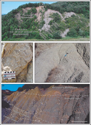
Ponsano Sandstone (pst) consists of tabular to gently lobate lithosomes of hybrid and fossiliferous, fine- to medium-grained, bioturbated sandstone (a). Marlstone and gravel is subordinate. Lobate lithosomes have less than 1 m of relief over 100 m along strike. CitationForesi, Pascucci, and Sandrelli (1997) analysed the rich fossiliferous content and reconstructed a section of at least 450 m, describing offshore-transition, shoreface and subaqueous fan-deltaic facies organized in stacked coarsening-upward successions. Lenses of coarse-grained, fan-deltaic deposits occur at the top of the unit, and have been mapped as a distinct deltaic top member (dtm), in places gradational with alluvial fan deposits of the overlying depositional unit tt1.
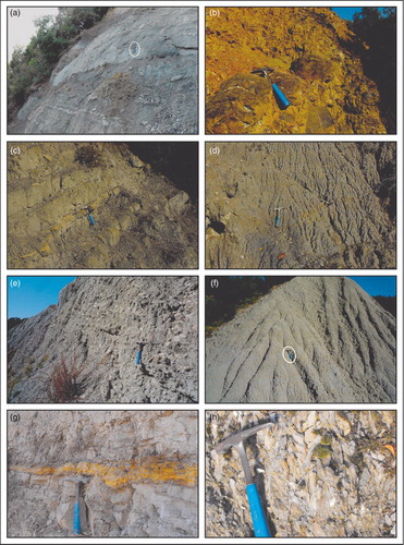
Figure 4. Outcrop expression of some of the lithostratigraphic units described, with emphasis on non-marine facies. Hammer for scale, circled in (a, f), is ca. 30 cm long. (a) Tabular to gently lobate sandstone lithosomes belong to the shoreface-dominated Ponsano Sandstone (pst), depositional unit st1. (b) Hematite-cover gravel and unsorted, coarse-grained sandstone compose lobate bodies within the alluvial Lower red beds (lrb), depositional unit tt1. (c) Thin-bedded marlstone, fine-grained sandstone and fossiliferous limestone with marine affinity occur with the shallow lacustrine-paralic Bithynia Marlstones (bml), depositional unit tt1. (d) Iron oxide-rich shale and medium-grained sandstone compose extensive sheets of the mudflat-dominated Lower shales (lsh), depositional unit tt1. (e) Fluvial gravel and unsorted coarse-grained sandstone infill incised palaeo-valleys, and compose the Upper red beds (urb), depositional unit tt2. (f) Sheet-bedded marly shale and marlstone with freshwater lacustrine to brackish-lagoon affinity compose the Melanopsis Marlstones (mml), depositional unit tt2. (g) A thin gypsum-arenite bed comprised within marlstone and shale, Lagoon shales (lgs), depositional unit ms1. (h). Close-up of a gypsum seam contained within the Messinian marine to evaporitic strata (mes) of depositional units ms2–3, a record of the late Miocene Mediterranean salinity crisis.
3.2. Depositional Unit tt1
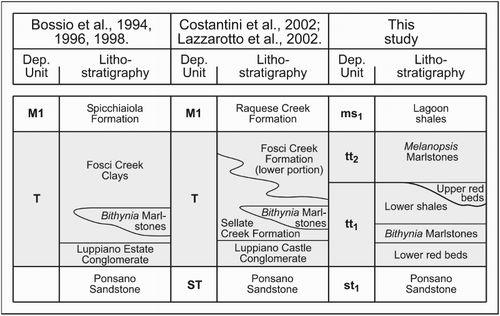
Early - middle (?)/late Tortonian non-marine to paralic deposits composes the depositional unit tt1, which lies onto the depositional unit st1 either: unconformably, with angularity in places, and up to 130 m of erosional relief over 5 km along dip; paraconformably or conformably, through slightly erosive or gradational contacts, respectively (CitationIelpi & Cornamusini, 2012). In the latter case, a superimposition of genetically related facies is observed. Despite classically considered as a widespread unconformity (CitationBossio et al., 2002; CitationLazzarotto & Sandrelli, 1977; CitationLazzarotto et al., 2002; CitationMartini, Pascucci, & Sandrelli, 1995), the local gradational nature of the depositional unit tt1 bottom was already at least in part envisaged in CitationGiannini and Tongiorgi (1959) and CitationForesi et al. (1997). The top contact is represented by an extensive truncation throughout the entire study area (), with characteristics of angularity with the overlying depositional unit tt2. Depositional unit tt1 is composed of three lithostratigraphic units, from the lowermost: Lower red beds, Bithynia Marlstones and Lower shales ().
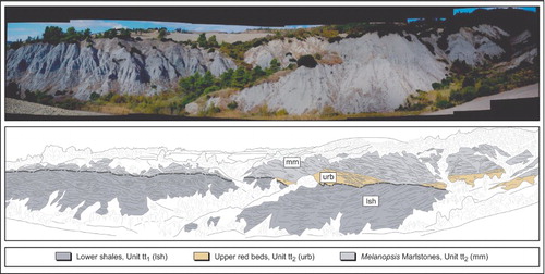
Figure 5. The spectacular badlands exposure near Spicchiaiola, in the central study area, reveals the presence of a previously unmapped surface of angular unconformity within the non-marine facies of the south-eastern Volterra Basin (depositional units tt1-tt2 boundary). The field of view is towards the east, and is ca. 1 km wide.
3.2.1. Lower red beds
Lower red beds (lrb) constitute a widespread interval in the whole post-orogenic hinterland (CitationCostantini et al., 2002, Citation2009), and are composed of hematite-coated gravel and subordinate coarse-grained sandstone (b). Deposits are overall fining-upward, 3–180 m thick, both matrix- and clast-supported, and forming lensoid bodies up to 5 m thick and 30 m wide along strike. Considering their sedimentology and barren character, CitationMartini et al. (1995) interpreted these deposits as alluvial fan and fluvial facies, the latter mapped here as a top channelised member (ctm).
3.2.2. Bithynia Marlstones
Bithynia Marlstones (bml) consist of coal-bearing, interbedded marlstones and minor medium- to fine-grained sandstone (c), classically interpreted as marginal to shallow lacustrine facies (CitationBossio et al., 1996). Fossiliferous limestone key-beds with marine-paralic affinity have been recently reported, suggesting the punctuated influence of marine waters (CitationIelpi, 2013). Bithynia Marlstones are up to 35 m thick and their internal architecture is characterized by bodies with less than 2 m of relief over 5 km along strike.
3.2.3. Lower shales
Lower shales (lsh) were treated in the literature as an undivided bulk of non-marine beds, together with the overlying deposits of Unit tt2 (‘Fosci Creek Clays’ in CitationBossio et al., 1996; ). The Lower shales consist of fines rich in freshwater fauna, medium-grained, iron oxide-rich sandstone, and channelised gravel at the top (d). CitationMartini et al. (1995) described shallow lacustrine to mudflat facies with minor distributary channels. Lower shales are 10–60 m thick, and their internal architecture is characterized by extensive sheets, traceable for up to 300 m along both strike and dip.
3.3. Depositional unit tt2
Middle (?)/late Tortonian to earliest Messinian non-marine deposits comprise the depositional unit tt2, which rests atop an unconformity displaying up to 70 m of erosional relief over 5 km along dip, and characterized by 35° to 5° of angularity from the NE-basin margin to the SW-depocentral area (). Since they are comprised within monotonous, shale-dominated successions, this unconformity was not recognized in earlier literature (CitationBossio et al., 1994, Citation1996; CitationLazzarotto et al., 2002). The top is instead flat, conformable and gradational with depositional unit ms1. Depositional unit tt2 consists of two lithostratigraphic units, from the bottom, Upper red beds and Melanopsis Marlstones ().
3.3.1. Upper red beds
Upper red beds (urb) constitute gravel-dominated, clast-supported bodies barren of fossils and floored by a composite erosional surface (e and ). These deposits were previously ranked as generic lithosomes engulfed in non-marine shale (CitationBossio et al., 1996; CitationMartini et al., 1995) but, given the importance of the underlying erosional surface, they are here proposed as a distinct lithostratigraphic unit (see diagnostic criteria of CitationHolbrook, 2001; and CitationIelpi et al., 2014). The Upper red beds constitute the fining-upward fill of four palaeo-valleys incised onto the Lower shales, up to 25 m thick and 0.8–1.5 km wide along strike.
3.3.2. Melanopsis Marlstones
Melanopsis Marlstones (mml) represent the topmost tract of the previously undivided non-marine deposits (; CitationMartini et al., 1995), and consist of tabular-bedded sheets of iron oxide-rich marly shale, marlstone, and calcareous marlstone (f). Sheets are more than 250 m wide along both strike and dip, and the thickness of the lithostratigraphic unit ranges from 10 to 120 m. The lithostratigraphic unit is floored by a well-developed hydromorphic palaeosol, thick up to 50 cm and continuous along most of the study area. The fossil content indicates the progression from a lower freshwater to an upper brackish environment (CitationBossio et al., 1996), consistent with an upward-increase in carbonate content. When close to the scoured depressions hosting the Upper red beds, a distinctive slumped bedset occurs at the base of the unit (d), and has been mapped as a separate member (Intraformational slump, slp).
Figure 6. Structural features of the study area. (a) Normal fault with a right-transtensional component, and associated drag-fold (to the right) showing the deposits of depositional unit tt1. The fault shows the north-eastern, basin-margin sector of the study area, and is one of the few fragile structures at the map scale. (b) The oblique growth of calcite fibres along the fault planes point to transtensional kinematics. (c) Recumbent, small-scale slump folds within the Melanopsis Marlstones. (d). Outcrop expression and line-drawing of a well-exposed slumped layer flooring the depositional unit tt2. The chaotic nature and the restricted thickness of the folded interval suggest gravitational deformation processes associated with tectonic destabilization.
3.4. Depositional Units ms1-3, pl1, qt1, and slope-degradation deposits
3.4.1. Lagoon shales
Early Messinian deposits compose the depositional unit ms1, consisting of the tabular-bedded Lagoon shales (lgs; shale, minor sandstone and gypsum-arenite; g) that conformably overlie the non-marine deposits. Lagoon shales are some 70 m thick, with a faunal association of benthic foraminifera and ostracods typical of brackish, lagoon environments (CitationBossio et al., 1996).
3.4.2. Messinian marine to evaporitic strata
Early to middle/late Messinian deposits compose the depositional units ms2-3 and have been collectively mapped as Messinian marine to evaporitic strata (mes), a succession that in the study area reaches up to 80 m in thickness. The two depositional units, undivided in the map, are gradational with each other and rest atop an erosional surface that scours the Lagoon shales without angularity. This heterogeneous association of deposits comprise, from the bottom: fossiliferous shale, interbedded patch-reef carbonate and gravel, gypsum and gypsum-rich shale (h), sandstone and travertine. Lower marine facies are sharply overlain by gypsum seams thought to record a Mediterranean-scale hydrologic failure (CitationKrijgsman et al., 1999; CitationTesta & Lugli, 2000), while the upper deposits record a brackish lacustrine setting with variable salinity (CitationRiforgiato et al., 2011).
3.4.3. Zanclean marine strata
Zanclean marine strata (pms) unconformably overlie Miocene deposits with angularity, and compose the depositional unit pl1. This is represented in the study area by a fining-upward succession of clast-supported gravel (sometimes with scattered boulders) and interbedded shale and medium- to fine-grained sandstone. A rich fossiliferous association indicates marine-deltaic to offshore-transition environments (CitationCostantini et al., 2002).
3.4.4. Pleistocene-Holocene alluvium and slope-degradation deposits
A late Pleistocene to Holocene coverage comprises valley-bottom alluvium, both active and terraced (al0 and al1, respectively), and belonging to the depositional unit qt1. Along the slopes, talus and colluvial debris, and active and inactive landslides have been mapped but, considering their scattered nature and current evolution, they have not been included into a depositional unit. The abundance of poorly consolidated lithotypes within the Volterra Basin favours fast weathering, and significantly contributes to the genesis and evolution of the slope-deposit coverage (CitationBertocci et al., 1995; CitationHobbs, 2000).
4. Structural features
The study area is characterized by two different structural styles. Bedrock originally belonged to an ocean-plain domain (CitationBertini et al., 2000), and shows polyphase deformation resulted from tectonic uprooting, 100 km-scale displacement, and subsequent post-orogenic collapse (CitationCarmignani, Conti, Cornamusini, & Meccheri, 2004). The Volterra Basin fill is instead considered autochthonous (CitationCostantini et al., 2002; CitationLazzarotto et al., 2002), its overall limited deformation derived from processes of crustal stretching and rifting (cf. CitationBonciani, Callegari, Conti, Cornamusini, & Carmignani, 2005; CitationPascucci et al., 1999).
Despite the attitude of the strata being somewhat dispersed in places, regional bedding in the south-eastern Volterra Basin displays NW-SE strike and gentle (∼15°) NW dip. Four classes of deformation elements occur in the study area: major blind faults not reaching the surface and imaged by seismic sections (1); outcrop-scale faults, both normal (2) and transtensional (3); and gentle, open folds (4). Seismic surveys imaged a low-angle, east-dipping detachment flooring the basin and kinematically linked to basin-centre blind, NNE-SSW-striking normal faults that propagate throughout the Miocene deposits, seemingly not cutting through the younger Pliocene strata (CitationBossio et al., 1997; CitationPascucci, 1997). The inferred traces of these blind normal faults are reported in c. Outcrop-scale fault structures are more scattered (a), and prone to have significance towards the NE, in the basin-margin portions of the study area (c). Basin fill and bedrock are separated by NW-SE-striking master normal faults, and by a NE-SW-trending transtensional faults in the eastern study area. Similarly, faults related to the basin fill have both SE-NW and, subordinately, SW-NE strike, displaying normal to transtensional kinematics and ESE-WNW direction of stretching (b). Differential displacement of some faults in the basin fill is apparent, pointing to syn-sedimentary slip. This feature is particularly evident along the normal fault to the east of Montescuro (b). While syn-sedimentary displacement is appreciable along the Miocene and Pliocene deposits, it is not clear whether outcrop-scale faults are sealed or cut through the Quaternary alluvium. Very gentle folds occur with WNW-ESE and NW-SE striking axes that gentle dip towards NNW, with a vertical to sub-vertical axial plane. Folding structures are not prominent in the field, and their inference is mainly based on changes in bedding. Significant open folds with amplitudes ranging from 50 to 200 m, become progressively gentler towards the south-western basin-central portion of the study area. Their spatial occurrence shows clustering (c), which is partly associated with increasing angularity across the depositional units tt1-tt2 boundary (CitationIelpi & Cornamusini, 2012). Tighter drag folds with vertical limbs occur locally, and are kinematically linked with normal faults (a). Small-scale recumbent and chaotic folds also occur within or nearby major slumped layers affecting the lowermost deposits of the depositional unit tt2. These latter folding structures seem to be restricted to a temporal interval comprised of the middle (?)/late Tortonian, suggesting enhanced tectonic instability of the basin margins related to the generation of the angular unconformity between depositional units tt1 and tt2 (c, d).
Overall, the shared strike and kinematic connection of fault and fold structures is consistent with the WSW-ENE-oriented extensional regime already described in earlier literature (CitationBossio et al., 1997; CitationCostantini et al., 2002; CitationCarmignani et al., 2004; CitationPascucci, 1997; CitationLazzarotto et al., 2002).
5. Conclusions
Field-geological mapping was performed on the south-eastern Volterra Basin, a crucial sector of the late Miocene Northern Apennines hinterland, and was supported by stratigraphic and structural analyses. In partial revision to the previous literature, several depositional units were recognized in the study area, spanning in age from late Serravallian to Zanclean. Depositional units are locally covered under late Pleistocene-Holocene landslides and colluvial-alluvial deposits, some of which are still evolving.
Within the non-marine portion of the basin fill, two depositional units comprise five lithostratigraphic units. The stratigraphic survey underlined the locally conformable nature of the lower boundary of the non-marine succession, and an internal, previously unmapped surface of angular truncation has been identified. The depositional evolution of the non-marine deposits is characterized by, from the oldest event: early - middle (?)/late Tortonian alluvial-fan to fluvial deposition, followed by expansion of shallow paralic lakes with marine influence, which evolved into extensive mudflats transected by distributary channels; and middle (?)/late Tortonian to earliest Messinian down-cutting and filling of fluvial palaeo-valleys, followed by the re-expansion of freshwater lakes that eventually evolved into brackish lagoons.
Finally, the structural framework of the study area is characterized by: blind normal faults only imaged by seismic sections; outcrop-scale normal and transtensional faults; and gentle folds with local vertical to recumbent chaotic limbs. These three classes of deformation structures appear kinematically connected, and the distribution of folding elements seems to have controlled the angularity across unconformities. Our structural assessment on the basin fill substantially agrees with earlier literature, suggesting a geodynamic framework dominated by crustal stretching.
Main Map: Geology of the Late Miocene South-Eastern Volterra Basin (Northern Apennines, Italy)
Download PDF (4.1 MB)Acknowledgments
The research was in part funded by the International Association of Sedimentologists Grant Scheme (2nd session, 2011). Reviewers Riccardo Bersezio of University of Milan, Thomas Pingel of Northern Illinois University, and Antonio Funedda of University of Cagliari provided useful reviews and are warmly acknowledged.
Software
Esri ArcMap 9.1 was used for implementing the topographic basemap. Macromedia Freehand MX was used for map digitization and drafting of the figures.
Related Research Data
References
- Benvenuti, M., Papini, M., & Rook, L. (2001). Mammal biochronology, UBSU and paleoenvironment evolution in a post-collisional basin: Evidence from the Late Miocene Baccinello-Cinigiano basin in southern Tuscany, Italy. Bollettino della Società Geologica Italiana, 120, 97–118.
- Bertini, G., Cornamusini, G., Lazzarotto, A., & Maccantelli, M. (2000). Stratigraphic and tectonic framework of the Ligurian Units in the Castellina M.ma Hills (southern Tuscany, Italy). Bollettino della Società Geologica Italiana, 119, 687–701.
- Bertocci, R., Canuti, P., Casagli, N., Garzonio, C. A., & Vannocci, P. (1995). Landslides on clay and shale hillslopes in Tuscany, Italy. In clay and shales slope instability. By Haneberg, W.C., Anderson, S.A., Geological Society of America. Annual Reviews in Engineering Geology, 10, 107–120.
- Boccaletti, M., Bonini, M., Moratti, G., & Sani, F. (1999). Compressive Neogene-Quaternary tectonics in the hinterland area of the Northern Apennines. Journal of Petroleum Geology, 22, 37–60.
- Bonciani, F., Callegari, I., Conti, P., Cornamusini, G., & Carmignani, L. (2005). Neogene post-collisional evolution of the internal Northern Apennines: Insights from the upper Fiora and Albegna valleys (Mt. Amiata geothermal area, southern Tuscany). Bollettino della Società Geologica Italiana, Special Volume 2005/3, 103–118.
- Bossio, A., Cerri, R., Mazzei, R., Salvatorini, G., & Sandrelli, F. (1994). The neoautochthonous succession of the Spicchiaiola-Pignano area, east of Volterra (southern Tuscany, Italy). Memoria della Società Geologica Italiana, 48, 425–430.
- Bossio, A., Cerri, R., Mazzei, R., Salvatorini, G., & Sandrelli, F. (1996). Geologia dell'area Spicchiaiola-Pignano (settore orientale del Bacino di Volterra). Bollettino della Società Geologica Italiana, 115, 393–422.
- Bossio, A., Costantini, A., Foresi, L. M., Lazzarotto, A., Mazzanti, R., Mazzei, R., Pascucci, V., Salvatorini, G., Sandrelli, F., & Terzuoli, A. (1998). Neogene-Quaternary evolution in the western side of the Northern Apennines (Italy). Memorie della Società Geologica Italiana, 52, 513–525.
- Bossio, A., Foresi, L. M., Mazzei, R., Salvatorini, G., Sandrelli, F., Bilotti, M., Colli, A., & Rossetto, R. (2004). Geology and stratigraphy of the southern sector of the Neogene Albegna River Basin (Grosseto, Tuscany, Italy). Geologica Romana, 37, 165–173.
- Bossio, A., Mazzei, R., Foresi, L. M., Pascucci, V., Salvatorini, G., & Sandrelli, F. (1997). Allostratigraphy and seismic stratigraphy of the Miocene sediments of the Spicchiaiola-Pomarance area, southern side of the Volterra Basin (Tuscany, Italy). Rivista Italiana di Stratigrafia e Paleontologia, 103, 357–368.
- Bossio, A., Mazzei, R., Salvatorini, G., & Sandrelli, F. (2002). Geologia dell'area compresa tra Siena e Poggibonsi (“Bacino del Casino”). Atti della Società Toscana di Scienze Naturali, Memorie, Serie A, 2000–2002, 69–85.
- Carmignani, L., Conti, P., Cornamusini, G., & Meccheri, M. (2004). The Internal Northern Apennines, the Northern Tyrrhenian Sea and the Sardinia-Corsica Block. In Geology of Italy. By Crescenti, U., D'Offizi, S., Merlino, S., Sacchi. L., Special Volume of the Italian Geological Society, IGC 32 Florence 2004, 59–77.
- Carmignani, L., Conti, P., Cornamusini, G., & Pirro, A. (2013). Geological Map of Tuscany. Journal of Maps, 9, 487–497.
- Carmignani, L., Decandia, F. A., Fantozzi, P. L., Lazzarotto, A., Liotta, D., & Meccheri, M. (1994). Tertiary extensional tectonics in Tuscany (Northern Apennines, Italy). Tectonophysics, 238, 295–315.
- Carnevale, G., Longinelli, A., Caputo, D., Barbieri, M., & Landini, W. (2008). Did the Mediterranean marine reflooding precede the Mio-Pliocene boundary? Paleontological and geochemical evidence from the upper Messinian sequences of Tuscany, Italy. Palaeogeography, Palaeoclimatology, Palaeoecology, 257, 81–105.
- Cornamusini, G., Foresi, L. M., Dall'Antonia, B., Bossio, A., Mazzei, R., & Salvatorini, G. (2014). The Miocene of the Pianosa Island: Key to understanding the opening of the Northern Tyrrhenian back-arc basin (Central Mediterranean). Journal of the Geological Society. doi:10.1144/0016-76492013-112.
- Cornamusini, G., Foresi, L. M., Massa, G., Bonciani, F., Callegari, I., Da Prato, S., & Ielpi, A. (2011). The Miocene succession of the Fiora Hills: Considerations about the development of the minor basins of Southern Tuscany. Italian Journal of Geosciences, 130, 404–424.
- Costantini, A., Decandia, F. A., Lazzarotto, A., Liotta, D., Mazzei, R., Pascucci, V., Salvatorini, G., & Sandrelli, F. (2009). Note Illustrative della Carta Geologica d'Italia alla scala 1:50.000, Foglio 296 Siena. Firenze, Italy: Servizio Geologico d'Italia, L.A.C.
- Costantini, A., Lazzarotto, A., Mazzanti, R., Mazzei, R., Salvatorini, G., & Sandrelli, F. (2002). Note Illustrative della Carta Geologica d'Italia alla scala 1:50.000, Foglio 285 Volterra. Firenze, Italy: Servizio Geologico d'Italia, L.A.C.
- Foresi, L. M., Cornamusini, G., Bossio, A., Ferrandini, M., Mazzei, R., Salvatorini, G., & Argenti, P. (2000). The Miocene sedimentary succession of the Pianosa island, northern Tyrrhenian Sea. Proceedings of “Evoluzione geodinamica dell'Appennino”, Foligno (Italy), 155–157.
- Foresi, L. M., Pascucci, V., & Sandrelli, F. (1997). Sedimentary and ichnofacies analysis of the epiligurian Ponsano Sandstone (northern Apennine, Tuscany, Italy). Giornale di Geologia, 59, 301–314.
- Foresi, L. M., Bambini, A. M., Mazzei, R., Piccinelli, B., & Sandrelli, F. (2003). La base dell'Arenaria di Ponsano nella sua area tipo e nella zona di Casole d'Elsa (Toscana). Atti della Società Toscana di Scienze Naturali, Memorie, Serie A, 108, 1–6.
- Ghelardoni, R., Giannini, E., & Nardi, R. (1968). Ricostruzione paleogeografica dei bacini neogenici e quaternary della bassa valle dell'Arno sulla base dei sondaggi e dei rilievi sismici. Memorie della Società Geologica Italiana, 7, 91–106.
- Giannini, E. & Tongiorgi, M. (1959). Stratigrafia neogenica Toscana 1. – L'arenaria Elveziana di Ponsano (Volterra). Bollettino della Società Geologica Italiana, 78, 83–100.
- Hobbs, P. R. N. (2000). Landslides at Volterra, Tuscany, Italy. Quarterly Journal of Engineering, Geology and Hydrology, 33, 101–103.
- Holbrook, J. (2001). Origin, genetic relationships, and stratigraphy over the continuum of fluvial channel-form bounding surfaces: An illustration from middle Cretaceous strata, southeastern Colorado. Sedimentary Geology, 144, 179–222.
- Hsü, K. J., Montadert, L., Bernoulli, D., Cita, M. B., Erickson, A., Garrison, R. E., Kidd, R. B., Mèlierés, F., Müller, C., & Wright, R. (1977). History of the Mediterranean salinity crisis. Nature, 267, 399–403.
- Ielpi, A. (2013). Frequency-reliant correlative patterns of asymmetric lacustrine-paralic sequences: A genetic approach to the late Miocene Bithynia Marlstones of the south-eastern Volterra Basin, Italy. Journal of Sedimentary Research, 83, 377–394.
- Ielpi, A., & Cornamusini, G. (2012). A progressive unconformity-bounded stratigraphic unit within extensional settings, SE Volterra Basin, Italy. Rendiconti Online della Società Geologica Italiana, 21, 1047–1049.
- Ielpi, A., Gibling, M. R., Bashforth, A. R., Lally, C., Rygel, M. C., & Al-Silwadi, S. (2014). Role of vegetation in shaping Early Pennsylvanian braided rivers: Architecture of the Boss Point Formation, Atlantic Canada. Sedimentology. doi:10.1111/sed.12109
- Krijgsman, W., Hilgen, F. J., Raffi, I., Sierro, F. S., & Wilson, D. S. (1999). Chronology, causes and progression of the Messinian salinity crisis. Nature, 400, 652–655.
- Lazzarotto, A., & Mazzanti, R. (1976). Geologia dell'Alta Val di Cecina. Bollettino della Società Geologica Italiana, 95, 1365–1480.
- Lazzarotto, A., & Sandrelli, F. (1977). Stratigrafia e assetto tettonico delle formazioni neogeniche nel Bacino del Casino (Siena). Bollettino della Società Geologica Italiana, 96, 747–762.
- Lazzarotto, A., Sandrelli, F., Foresi, L. M., Mazzei, R., Salvatorini, G., Cornamusini, G., & Pascucci, V. (2002). Note Illustrative della Carta Geologica d'Italia alla scala 1:50.000, Foglio 295 Pomarance. Firenze, Italy: Servizio Geologico d'Italia, L.A.C.
- Martini, I. P., Pascucci, V., & Sandrelli, F. (1995). Late Miocene paleogeography of the Monte Soldano area, southeastern part of the Volterra Basin, Tuscany, Italy. Rivista Italiana di Stratigrafia e Paleontologia, 101, 381–388.
- Martini, I. P., & Sagri, M. (1993). Tectono-sedimentary characteristics of Late Miocene-Quaternary extensional basins of the Northern Apennines, Italy. Earth-Science Reviews, 34, 197–233.
- Pascucci, V. (1997). Seismic comparative study of an onshore and offshore basin of Tuscan and Tuscan Shelf (Italy). Giornale di Geologia, 59, 289–300.
- Pascucci, V., Merlini, S., & Martini, I. P. (1999). Seismic stratigraphy of the Miocene-Pleistocene sedimentary basins of the Northern Tyrrhenian Sea and western Tuscany (Italy). Basin Research, 11, 337–356.
- Riforgiato, F., Foresi, L. M., Di Stefano, A., Aldinucci, M., Pelosi, N., Mazzei, R., Salvatorini, G., & Sandrelli, F. (2011). The Miocene/Pliocene boundary in the Mediterranean area: New insights from a high-resolution micropalaentological and Cyclostratigraphic study (Cava Serredi section, Central Italy). Palaeogeography, Palaeoclimatology, Palaeoecology, 305, 310–328.
- Rook, L., & Ghetti, P. (1997). Il Bacino neogenico della Velona (Toscana, Italia): Stratigrafia e primi ritrovamenti di vertebrati fossili. Bollettino della Società Geologica Italiana, 116, 335–346.
- Rook, L., Oms, O., Benvenuti, M. G., & Papini, M. (2011). Magnetostratigraphy of the Late Miocene Baccinello-Cinigiano basin (Tuscany, Italy) and the age of Oreopithecus bambolii faunal assemblage. Palaeogeography, Palaeoclimatology, Palaeoecology, 305, 286–294.
- Salvador, A. (1987). Unconformity bounded stratigraphic units. Geological Society of America, Bulletin, 98, 232–237.
- Testa, G., & Lugli, S. (2000). Gypsum-anhydrite transformations in Messinian evaporites of central Tuscany (Italy). Sedimentary Geology, 130, 249–268.