
Abstract
The presented maps provide an example of the synoptic display of multi-scale geological features characterizing the tectono-metamorphic evolution of the crystalline basement terranes in a poly-orogenic-multistadial evolutionary scenario. The petro-structural map of the eastern Aspromonte Massif (southern Calabrian Peloritani Orogen) is characterized by a nappe-like edifice composed by the superimposition of three crystalline basement tectonic units which, sharing the same Alpine-Apennine reworking, underwent a different metamorphic evolution, mostly derived from the Hercynian orogenic cycle. This geological framework is completed by the suture deposition of a Oligocene-Miocene syn-orogenic clastic formation, partly roofed by the back-thrusting of a clay-rich mélange. In order to understand the potential relationships within the complex dataset deriving from the geological investigations of this crystalline basement area, a geo-database, capable of handling multi-scale information from field-derived structural data (i.e. foliation, lineation, fold- and fault-related structures) to micro-scale derived ones (i.e. thin-section analysis, electron microscope and microprobe investigations, thermodynamic modeling outputs) has been constructed, according to the international standards using the Geo-Scientific Markup Language developed by the Commission for the Management and Application of Geo-science Information. Proposed outputs will show the relationships between field-related geological features, showing collected samples and the subsequent laboratory investigations. These are fundamental to achieving reliable results in geological contexts, such as those for reconstructing the tectono-metamorphic evolution of crystalline basement terrains.
1. Introduction
Geological mapping of crystalline basement areas requires the possibility of handling multi-scale geological data from the outcrop to the thin section-scale and beyond in order to permit the interaction between meso-structural data with micro-analytical investigations. Over the last decade the increased availability of sophisticated analytical techniques that have been routinely performed, from the Scanning Electron Microscope (SEM) and Electron Probe Micro Analyzer (EPMA) investigations through to in-situ isotopic and geochronological investigations.
This lays the groundwork for the development of a data-management system useful to permit functional data-interaction, even more so when the acquisition and/or the data-processing derive from research groups whose members are increasingly far apart.
In order to establish a more consistent ontology and vocabularies the geo-science community is interested in geological information modeling based on a structured framework of the geological domain, aimed at upgrading geospatial data mapping, especially focused on continuity and compatibility between output generated by different systems, implementing real interoperability between heterogeneous software platforms.
As a result the IUGS (International Union of Geological Sciences) has recently provided considerable resources in order to achieve a global reference model, now published as the GeoSciML (Geoscience Markup Language) (CitationLaxton et al., 2010). This standard application-schema is proposed using the UML (Unified Modeling LanguageFootnote1) (CitationBooch, 1996; CitationLlano & Pooley, 2009).
In this context GIS-based Petro-Structural Map of the eastern Aspromonte Massif crystalline basement aims to structure an example of a pluri-geothematic interactive map. This would be an intuitive tool capable offing display the relationships between field geo-structural data, an articulated system of samples and sub-samples (i.e. portions of the original sample used for different analytical purposes) useful for acquiring: (i) mineral-chemical data; (ii) geochemical data; (iii) isotopic data; (iv) geothermobarometric constraints and so on, through the sampling point location.
This data infrastructure would guarantee high-quality data storage, application of the more common interpolation techniques (e.g. Spline, IDW, Kriging) (CitationIsaaks & Srivastava, 1988), useful to integrate field related data with datasets deriving from several laboratorial analytical sessions. The proposed database infrastructure is primarily based on the last INSPIRE (Infrastructure for Spatial Information in the European Community) guidelines in terms of syntax and logical relations, integrated with the FGDC-GDS (Federal Geographic Data Committee – Geological Data Subcommittee) (http://www.fgdc.gov) map symbols. This ensures, as far as possible, the interoperability of geospatial data, useful for developing new platforms of data sharing, which can potentially develop synergies, between individual research groups.
2. Methods
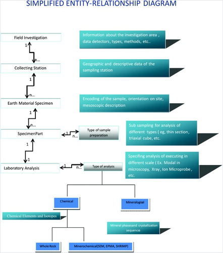
In order to manage all the information acquired during the phases of geological field investigation accompanied by laboratory analytical sessions, a new geotadabase called ‘FOS2MAN’ (From Outcrop Scale to MicroANalysis) (CitationZappalà, 2014), was developed using the GeoSciML model, in order to realize interoperability of geospatial data. The conceptual model of FOS2MAN describes the organization of the entities and their relationships including multiplicity and dependences (), looking for full interoperability among the most common geoscience data structures like PetLab (http://pet.gns.cri.nz/), MetPetDB (CitationSpear et al., 2009) and Earthchem (CitationWalker et al., 2005). FOS2MAN provides an organized scheme for detailed data acquisition aiming a self-consistent production of all the information potentially deriving, in our case study, from the crystalline basement geological survey of the eastern Aspromonte Massif.
Figure 1. FOS2MAN – Simplified diagram of the Entity-Relationship model (after CitationOrtolano & Zappala, 2012 modified). Acronym meaning: SEM: Scanning Electron Microscope; EPMA: Electron Probe Micro Analyzer; SHRIMP: Sensitive High Resolution Ion Micro Probe
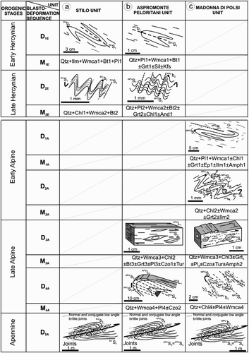
In order to organize evidence the on geological, structural and petrological features, producing a reliable reconstruction of the tectono-metamorphic evolution of this selected Alpine-Apennine sector chain of the southern peri-Mediterranean realm, the specific sequence of the blasto-deformational relationships have been reconstructed, integrating field-related data with petrographic and mineral chemical investigations (mineral abbreviations after CitationSiivola & Schmid, 2007). Particular attention is focused on the reconstruction of the tectono-metamorphic evolution of the two lowermost crystalline basement units, which underwent polyorogenic – multistadial evolution (CitationCirrincione et al., 2008a).
The sequence of foliations, lineations and fold related structures, as well as identified deformational events (potentially) accompanied by metamorphic ones, followed the customary time-related concept, where the eldest recognizable planar structural fabric without any evidence of sedimentary origin is indicated with the letter ‘S'followed by the subscript 1,2,3; the linear ones by the letter ‘L'followed by the same subscript sequence, as well as for the sequence of the folding axis ‘b'and for the deformational ‘D'or metamorphic event ‘M’, subscripted by the same progressive numeric sequence. To avoid confusion between structural sequences specifically observed within a single tectono-metamorphic unit, the specific structural symbol (i.e. S, L or b) were preceded by the apex of a unit's acronym.
Finally, reported paragenetic equilibria follow the same time-related concept for those minerals clearly linked with a specific metamorphic event. The mineral chemical compositions of these equilibria have been used to constrain the PT evolution of the two lowermost outcropping crystalline basement units already calculated in CitationCirrincione et al. (2008a), by means of thermodynamic modeling via PT pseudosection calculation (CitationConnolly & Petrini, 2002).
The above description has resulted in a clear data structure for managing the multiscale features of the available geological data. A detailed hierarchical criterion, useful for managing the general and particular aspects of the field and laboratorial geological investigations, have been followed, including any typical elements of the metamorphic domain, sampling data storage, handle sampling description and characterization, analytical chemistry from bulk analysis to microstructural and mineral-chemical observation.
In this view, during the production of FOS2MAN our attention has been particularly focused on addressing parental relationships existing between the sampling site, as the single outcrop framed within a ‘geological unit’, the earth material sampled from the site or the sample collection, the reduction in subsample and the part to be analyzed, with each one treated with a specific method or analytical process ().
Figure 2. FOS2MAN – Conceptual model of the Entity-Relationship (after CitationOrtolano & Zappala, 2012 modified)
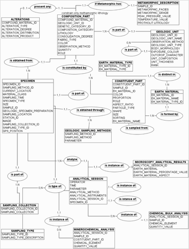
The graphical representation of the structural-geological data refers to a model proposed by the FGDC-GDS (http://www.fgdc.gov). Such a decision was taken that, whilst the INSPIRE model is representative for European geosciences data sharing, it is less refined and sometimes lacking in several aspects (e.g. specific structural-geological symbolization such as faults, foliations, lineations, cleavages, folds and joints symbols). Geo-structural symbolization in INSPIRE is relatively poor at representing the various aspects of geo-structural investigations, beginning from mesoscale derived information and, even more so for those related to the domain of microanalysis.
More specifically geological features, such as those used to describe the entity ‘fault’, can be less or more specified with information derived from the feature. For example, the entity fault can be generally specified as: generic, vertical, sub-vertical, or high-angle; or unknown or unspecified orientation or sense of slip. The above generic characterization can be then be detailed as an entity ‘fault’ among ten types of faults, such as ‘Low-angle fault’, ‘Reverse fault’, Rotational or scissor fault, etc. In each case there are other rules to specify the identity, the certainty or location accuracy. By means of the combination of the above mentioned attributes, it is then possible to choose a specific symbol that represents a synthesis of all of them, identifying each single specific case.
For ‘Foliations’, it's possible to use generic foliation terms or, better, define any kind of primary foliation or secondary one, specifying where it is ‘vertical metamorphic’ or ‘tectonic foliation’ and if it appears showing strike or less. Using a specific symbol, the author can detail directly a mylonitic foliation or a horizontal eutaxitic one, providing the user a wide range of information, already clearly defined from the simple observation of the used symbols, coded according to international standards.
For ‘Lineations’ there are a lot of different ways to detail their origin and other geo-structural meanings such us stretching-, intersection- or mineral-lineation, just to mention a few.
Furthermore, as data within the database can potentially be acquired from different sources, it is noted to the left of each item. This work aims to highlight the uncertainty of the data through graphical representation (CitationBalestro et al., 2010, Citation2013).
Following the above mentioned concepts, two different outputs have been developed.
The first one (Map 1) provides a classic geological map 1:25,000 scale, supplemented with a detailed geological setting and four geological cross-sections. This first map has as a topographic base map, part of sheets 602 (first and second quadrant) and 603 (third and fourth quadrant) of the 1:25,000 scale topographic map of the military Italian geographic institute (IGM – Istituto Geografico Militare), projected according to WGS 84 / UTM zone 33N. The grid is in meters from the equator and latitude and longitude (from the Greenwich meridian), respectively.
The second cartographic output highlights the main structural features as well as the whole-rock- and mineral-chemistry of representative samples for the two lowermost crystalline basement units, depicted as a simplified geological map at 1:25,000 scale, using contour lines as a topographic base. Structural data were used to interpolate the average attitude and inclination of the mylonitic foliations as well as of the stretching lineations from about 500 structural stations, accompanied by stereoplots. Whole-rock and mineral-chemical data were used instead as input to derive the PT constraints calculated via thermodynamic modeling after CitationCirrincione et al. (2008a).
3. Geological setting
The study area is located in the eastern part of the Aspromonte Massif, a nappe-like structure consisting of three stacked crystalline basement units located in the southern part of the Calabrian Peloritani Orogen (CPO) () (Map 1). This is a relic fragment of the original southern European Variscides presently involved within the thin-skinned Apeninne thrust system, developed during the later stages of the Alpine orogenic cycle.
Figure 3. Synthesis of geological setting (a) Areal distribution of Alpine belt in the central Mediterranean realm; (b) Geological sketch map of Calabrian Peloritani Orogen (CPO) (modified after CitationAngì et al. 2010; CitationCirrincione et al., 2011). (c) Geological sketch map of the Aspromonte Massif (after CitationPezzino et al., 1990, Citation2008; CitationOrtolano et al., 2005; CitationFazio et al., 2008).
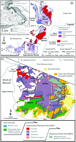
In this scenario, the crystalline basement units which constitute the backbone of the CPO are the result of a poly-orogenic multi-stage history (CitationBarbera et al., 2011; CitationCella et al., 2004; CitationCirrincione et al., 2008a) which has led to the formation of the present-day composite terrane (CitationCirrincione et al., 2010), composed of Variscan, or possibly older, sub-terranes (e.g. CitationCritelli, 1999; CitationCirrincione et al., 2005; CitationCritelli et al., 2011, Citation2013; CitationDe Gregorio et al., 2003; CitationFerla, 2000; CitationFiannacca et al., 2013; CitationMicheletti et al., 2007; CitationPezzino et al., 2008; CitationPerri et al., 2011; CitationPerri et al., 2013; CitationWilliams et al., 2012). The present-day lateral juxtaposition of these differently evolved sub-terranes were essentially due to the activation of an early deep seated strike-slip tectonics (CitationOrtolano et al., 2013), which accompanied the following Alpine-Apennine large-scale stacking activity, leading to the joining of originally separated crystalline basement domains. This work has the aim of expanding evidence of the specific structural and petrological features of the crystalline basement units outcropping in the eastern sector of the Aspromonte Massif for an area of about 135 Km2 (c) (Map 1).
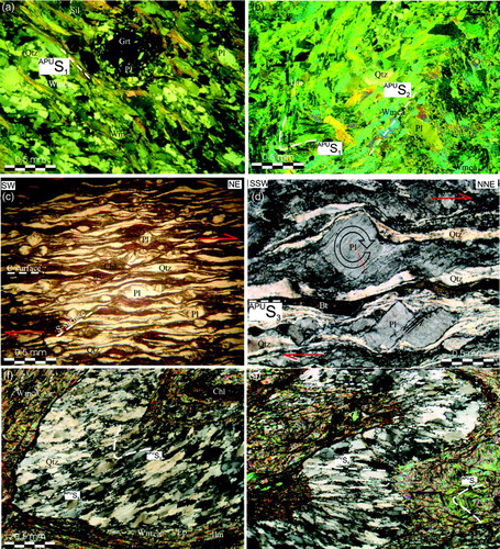
In particular, focus is on the uppermost unit of the thrust edifice of the Aspromonte Massif represented by the Stilo Unit (SU) (CitationCrisci et al., 1982; CitationFazio et al., 2012; CitationGraeßner & Schenk, 1999). In the mapped area, it outcrops as sporadic klippen and consists of very low-grade Hercynian metapelites (a). The SU lies in brittle tectonic contact over the Aspromonte-Peloritani Unit (APU), which is made up of amphibolite facies Paeleozoic rocks with late to post-Hercynian peraluminous intrusive bodies, locally overprinted by Alpine age metamorphism, developed along a deep-seated shearing zone at about 25–30 Ma (CitationBonardi et al., 1987; CitationBonardi et al., 2008; CitationCirrincione et al., 2009; CitationCirrincione et al., 2010) (b). This event, characterized by the evolution of a thick mylonitic horizon (CitationOrtolano, Cirrincione, & Pezzino, 2005), thrusted the APU onto the lowermost outcropping metapelite unit, which marks the beginning of the joint structural and metamorphic history of these two units. Before this event, the APU preserved clear relics of a metamorphic history, characterized by a prograde low pressure gradient evolution, peaking at low pressure (LP) high temperature (HT) conditions, ascribable to the later stages of the Hercynian orogenic cycle (CitationCirrincione et al., 2008a). By contrast, the lowermost unit, surfacing along several underlying low- to medium-grade tectonic windows: (a) the Cardeto window (CitationFazio et al., 2008); (b) the Madonna di Polsi window (CitationPezzino et al., 1990); (c) the Samo-Africo window (CitationMessina et al., 1992), seems to be characterized by a complete Alpine reworking (CitationHeymes et al., 2010) or to be exclusively affected by complete Alpine metamorphic cycle peaking at relatively HP conditions (CitationCirrincione et al., 2008a; CitationOrtolano et al., 2005; CitationPezzino et al., 2008), in view of the subtle identification of clear metamorphic relics ascribable to the previously detected orogenic events (c). According to this last view, this unit, named the Madonna di Polsi Unit (MPU) by CitationPezzino et al. (2008), can be framed within the southern CPO geodynamic scenario as a prevalent metapelite sequence, differently affected by an early Alpine evolution along an HP geothermal gradient (CitationCirrincione et al., 2008b). As a consequence of this proposed model, the comparison between Aspromonte Massif and Peloritani Mountains nappe-like edifices (CitationCirrincione et al., 1999; CitationCirrincione et al., 2012) was facilitated, contributing to our understanding of the location of this orogenic sector in the wider geodynamic puzzle of the western Mediterranean realm (e.g. CitationCritelli et al., 2008; CitationPerrone et al., 2006; CitationPerri et al., 2011, Citation2013; CitationZaghloul et al., 2010).
Figure 4. General mesoscopic features of the outcropping units (a) Klippen of phyllite of the Stilo Unit partially covered, in basal unconformity, by arenaceous levels of the Stilo-Capo D'Orlando Formation (SCOF); (a’) particular of the SU phyllite with widespread presence of quartz-rich isoclinals hinge depicting the SUS1 surface; (b) mylonitic leucocratic gneiss of the Aspromonte Peloritani Unit with kinematic indicator consistent with a top to NE sense of shear in the present-day geographic coordinates; (d) SCC’ mylonitic fabric in garnet-muscovite schist of the Madonna di Polsi Unit consistent with a top to NE sense of shear; (d) Particular of the stratigraphic basal alternance of the SCOF sequence passing from relatively thin levels of phyllite-rich clasts to relatively thick arenaceous levels.
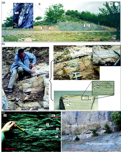
The study area is also characterized by the wide presence of the syn- to late-tectonic deposition of the silicic-clatic terrigeneous sequence named the Stilo-Capo D'Orlando Formation (SCOF) (CitationCavazza et al., 1997), locally suturing the contact between the APU and SU (d). The tectono-stratigraphic evolution of this sequence of the CPO southern sector terminates in this area with the back-thrusting (CitationOgniben, 1960, CitationTripodi et al., 2013) or re-sedimentation (CitationCavazza & Barone 2010; CitationCritelli et al., 2013), of a clay-rich mélange (i.e. the Varicolori Clays).
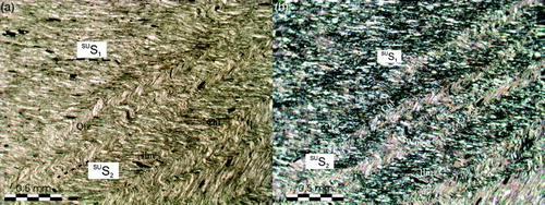
4. Structural and stratigraphic features
Structural investigations, synthetically summarized in , highlights that the Stilo Unit (a) underwent a mono-orogenic metamorphic cycle of Variscan age, characterized by a first stage of isoclinal folding deformation (SUD1) with formation of a pervasive axial plane schistosity (SUS1) (a’) clearly followed by a sub-millimeter sized micro-crenulation, leading to the formation of a pervasive axial culmination lineation (SUb2) (a). In the mapped area the SU is sandwiched between the overlying suturing of the SCOF, locally highlighted by the presence of rich-phyllite cataclastic mélanges, probably linked with a tectonic replacement of the original stratigraphic basal discordance (d), and the underlying APU. Also in this case this last tectonic contact is marked by a cataclastic horizon with no evidence of any relic of more deep-seated deformational structures.
Figure 5. Sequence of the blasto-deformation events of the metamorphic basement units of the studied area: (a) Stilo Unit; (b) Aspromonte Peloritani Unit; (c) Madonna di Polsi Unit (see text for the meaning of the acronyms)
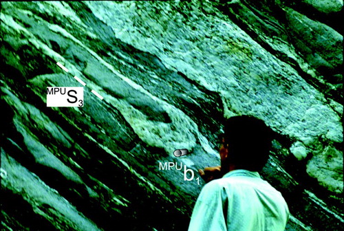
By contrast, the contact between the two lowermost tectonic units (i.e. APU and MPU), although also characterized by the presence of a relatively thick cataclastic horizon, shows clear evidence of a share weak to strong pervasive mylonitic foliation (CitationOrtolano et al., 2005). This deformational stage permits only rarely the preservation of the pre-mylonitic structures, presently observable at the micro-scale such as in the APU rock-types. It is rarely detected at the outcrop scale in the MPU rocks where, the first recognizable deformational event (MPUD1), characterized by the formation of an isoclinal fold axial plane foliation (MPUS1), is demonstrated by quartz-rich fold hinge relics within phyllite layers (). Occasionally a new subsequent surface (MPUS2) is also recorded, as a result of a millimeter wave-lengthned folding event (MPUD2) leading to the formation of a crenulation cleavage rarely evolving to a real schistosity (c).
Figure 6. Relic of isoclinals hinge within mylonitic layers in amphibole schist of the Madonna di Polsi Unit (Aposcipo river).
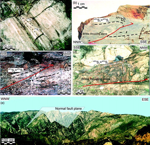
The subsequent deformational stage led to the formation of the share pervasive mylonitic foliation, APUS3, and MPUS3, for APU and MPU rocks, respectively, which also developed to a pervasive stretching lineation averagely trending SW-NE, with kinematic indicators consistent with a top to NE sense of shear in the present-day geographic coordinates (b and c and b and c). Mylonitic foliation evolves to an isoclinal folding deformation (b and c and a), suggesting that the two units underwent a similar deep-seated event, before being exhumed along a join brittle tectonic contact preceded by the formation of asymmetric folds, producing prevalent centimeter to decameter up to hectometer sized SSE-SE verging tectonic structures, accompanied by secondary conjugate NNW-NW verging ones (a–c and b–d) (Map 2). The activity of these two last deformational events have produced the folding of the original mylonitic layers, contributing to produce an anomalous thickening of the original mylonitic zone as well as repetition of the original contact, already locally preserved in some places (Map 1). This compressional tectonic activity is often accompanied by the activation of brittle strike-slip tectonics probably as re-activated relics of the early Alpine deep-seated strike-slip tectonics presently rarely preserved within the CPO (CitationOrtolano et al., 2013). This last tectonics led to the formation of fault system mainly oriented NW-SE and characterized both by right- or left-sided kinematism. In the mapped area, these structures are well preserved by the presence of part of the Bovalino-Bagnara strike-slip fault (CitationDel Ben et al., 2008), observable along the Buonamico river (Maps 1 and 2).
Figure 7. (a) Post-mylonitic isoclinal folding in laminated leucocratic gneiss (APU); (b), (c), (d) Fractal distribution of thrusting activity from centimeter to meter sized ramp and flat structures; (e) Triangular facets delineating normal fault planes along the southern slope of Monte Perre (Map 1).
The top of the nappe-like structure of the crystalline basement resulted in covering by the suturing activity of the Oligocene-Miocene SCOF, characterized by a conglomerate horizon gradually passing to thick arenaceous levels (d), evolving in turn to widely distributed pelite ones. Finally, in the eastern sector of the mapped areas, it is possible to recognizes, relatively thinned levels of Varicolori clays, interpreted as the result of the back thrusting activity of the clays of the original Sicilide basin (CitationOgniben, 1960; CitationTripodi et al., 2013).
The following detected tectonic activity terminates with the activation of a normal faulting system that marks the switch from a compressional to an extensional regime (CitationCirrincione et al., 2008b). This last deformational system is delineated by the presence of widespread high-angled joint systems, spanning from decimeter-sized fracture cleavage to kilometer size Horst and Graben structures (e), all of these averagely oriented WNW-ESE and WSW-ENE, following the formation of the main seismogenic structural systems (Map 2) (CitationMorelli et al., 2011, ITHACA Project).
5. Microstructural and Petrological Features
Microstructural and petrological analyses permitted integration of field investigations allowing reconstruction of the sequence of the blasto-deformational relationships of the outcropping crystalline basement units (), allowing us to constrain the evolution of the single unit in the frame of the present-day joint geological scenario.
5.1. Madonna di Polsi unit
The MPU rock-types outcropping in the study area are mainly constituted from south to the north by chlorite-muscovite schists (Qtz + Wmca + Chl + Pl ± Ep ± Ttn), muscovite-epidote schists (Qtz + Wmca + Ep + Pl ± Bt ± Chl ± Grt), muscovite-amphibole schists (Qtz + Wmca + Amph + Pl ± Bt ± Chl ± Ep ± Grt ± Ttn ± Rt) and muscovite-garnet schists (Qtz + Wmca + Pl + Grt ± Bt ± Chl ± Ep ± Ttn ± Rt), subordinately accompanied by calc-schist (Cc + Qtz + Wmca + Flog + Ab ± Ttn ± Ep ± opaques).
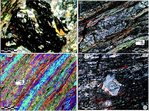
The evolution from the MPUD1 to MPUD2 deformational event is linked to the prograde metamorphic trajectory (MPUM1–MPUM2) characterized by a PT path ranging from 0.95 to 1.35 GPa for T from 400° to 560 °C, constrained by means of thermodynamic modeling of selected garnet-muscovite bearing schist, which allowed the better rocks to constrain the PT history of the unit in view of the presence of well preserved compositionally zoned pre-mylonitic garnet porphyroclast (XSps0.23-0.05, XGrs0.38-0.07, XAlm0.74-0.43, XPyr0.15-0.02) (Map 2) (CitationCirrincione et al., 2008a). This is indeed characterized by a complex system of inclusion trails highlighted by the alignment of ilmenite, epidote, chlorite and white mica with a moderate to high-phengite content (i.e. 3.04 to 3.35 Si a.p.f.u. – atom per formula unit) (a) (Map 2). The subsequent shear event (MPUD3) produced a pervasive mylonitic foliation MPUS3 and a stretching lineation MPUL1 (Maps 1 and 2) locally accompanied by the formation of syn-tectonic intrafolial asymmetrical folds, S-C and S-C-C’ fabrics as well as oblique foliation depicted by the alignment of quartz re-crystallized micrograins within pseudomorphosed ribbon-like quartz levels (b–d). Syn-mylonitic metamorphism (MPUM3), constrained by means of the widespread distributed syn-kinematic paragenetic equilibria (i.e. Qtz + Wmca3 + Chl3 ± Grt3 ± Pl3 ± Czo ± Tur ± Amph2), well demonstrated within the pressure shadows of the pre-kinematic garnet/feldspar porhyroclasts (d), retrogradely ranging from 560 to 480°C and from 0.95 to 0.50 GPa (Map 2). A fourth deformational stage (MPUD4) caused asymmetrical to isoclinal folding of the MPUS3 mylonitic foliation, rarely producing a new foliation surface (MPUS4).
Figure 8. Petrographical features of the Madonna di Polsi Unit (a) Inclusion trails within garnet porphyroclast of the MPU (nicols +); (b)Intrafoliar folds within mylonitic levels (MPU) (nicols +); (c) Oblique foliation given by the preferential elongation of new forming quartz grains within pseudomorphosed ribbon-like quartz level (MPU) (nicols + with quartz wedge); (d) Mylonitic micaschist with σ-type plagioclase porphyroclast and SC structure consistent with a top to NE sense of shear (MPU) (nicols +).
5.2. Aspromonte Peloritani unit
The main rock-types which constitute the APU are mainly represented by paragneiss and micaschist (Qtz + Pl + Bt + Wmca ± Sill + Kfs ± Grt ± And) and by augen gneiss (Qz + Pl + Kfs + Bt ± Ms), weakly to strongly mylonitic leucogneiss (Qtz + Pl + Wmca ± Kfs ± Bt), amphibolites and amphibole gneiss (Amph + Pl + Qtz + Bt ± Ttn ± Ep). A rare, unmappable, intrusion of weakly peraluminous trondhjemites (Qtz + Pl +Bt ± Kfs ± Wmca ±Sill) and strongly peraluminous leuco-granodiorites and granites (Qtz + Pl + Kfs + Wmca + Bt ± Sill ± And ± Crd) of late-Hercynian age, also occur (CitationFiannacca et al., 2005; CitationFiannacca et al., 2008; CitationRottura et al., 1990) .
The first relic deformational event (APUD1), linked to an early isoclinal folding, produced the oldest identifiable metamorphic surface (APUS1), dated to 330 Ma (CitationBonardi et al., 1987), (b and a). This stage is characterized by relic mineralogical assemblages consisting of quartz, andesine (Pl1), almandine garnet (with relatively low grossular and high spessartine contents) (Grt1), sillimanite, biotite (Bt1), muscovite s.s (Wmca1) ± K-feldspar. The microcrenulation of APUS1 represents the subsequent deformation phase (APUD2), locally producing a APUS2 schistosity (b and b), given by the aligned growth of Qtz+Pl2+Wmca2±Bt2±Grt2±Chl1±And1.
Figure 9. Petrographical features of the Aspromonte-Peloritani Unit (a) axial planar schistosity (APUS1) highlighted by Qtz + Pl1 + Bt1 + Wmca1 + Grt1 + Sill assemblage (nicols +); (b) Incipient crenulation schistosity (APUS2) developing in lepidoblastic levels of the sillimanite bearing paragneiss (APU) (nicols +); (c) Mylonitic paragneiss of the APU with SC structure consistent with a top to NE sense of shear (nicols +); (d) Mylonitic leucogneiss of the APU with δ-type and antithetic book-shelf-sliding structure consistent with a top to NNE sense of shear (nicols +); (e), (f) Post-mylonitic isoclinals folding with formation of new axial plane foliation (APUS4) (nicols +).
The following recognized mylonitic shearing stage (APUD3), developed along a deep-seated compressional shear zone (CitationOrtolano et al., 2005), coincide with the same mylonitic event (e.g. MPUD3) observed for the MPU (b and c). This last deformational stage gave rise to a pervasive overprint, which locally replaced the pre-existing foliations, producing a weak to strong grain size reduction (CitationCirrincione et al., 2009, Citation2010) (b and c and d). During this last stage a new mineralogical assemblage characterized by quartz, albite (Pl3), low phengite white mica (Wmca3), clinozoisite, ilmenite, chlorite, tourmaline (Tur1) and biotite (Bt3), occurs, where the iso-oriented micas layers depict the weakly to strongly pervasive mylonitic foliation (APUS3) and, on the foliation surface, the quartz ribbon-like layers delineate the stretching lineation (APUL1). A post-mylonitic deformational stage (APUD4) produces an isoclinal folding of the previous fabric with the formation of a new axial plane foliation (APUS4) parallel with the previously detected mylonitic one along which re-crystallize plagioclase (Pl4), white mica (Wmca4)and clinozoisite (b, a and e and f).
The PT range of the relic Variscan tectono-metamorphic evolution, constrained by means of the observed paragenetic sequence of the first sample, varies from 0.56±0.05 GPa at 570°±10°C to peak at conditions of 0.63 GPa for a temperature of 710°C (Map 2) (CitationCirrincione et al., 2008a). These conditions are in agreement with the occurrence of relic sillimanite in equilibrium with biotite inclusions within plagioclase cores. The following recognized paragenetic equilibria (i.e. Qtz + Pl2 + Wmca3 ± Bt2 ± Grt2 ± Chl1 ± And1) permitted depiction of an evolution consistent with a retrograde Variscan-type metamorphism, characterized by P of 0.25 GPa at T of 540°C (CitationCirrincione et al., 2008a; CitationOrtolano et al., 2005), probably linked to a late Variscan widespread episode of hydration under decreasing temperatures caused by the massive emplacement of metaluminous to strongly peraluminous late-Variscan granitoids at about 300 Ma (CitationAppel et al., 2011; CitationFiannacca et al., 2008; CitationRottura et al., 1990).
Finally, a subsequent late Alpine shearing event has been recognized, highlighted by a clear detectable retrograde mineral paragenesis (Qtz+Bt3+Wmca3+Chl2+± Grt3±Pl3±Tur) which allows the PT conditions for the mylonitic overprint to be constrained at a pressure of 0.38±0.14 GPa for a temperature of 475°±25°C (Map 2).
5.3. Stilo unit
The main recognized deformational events recognized in the rock-types of the Stilo Unit can be entirely ascribable to the Variscan orogeny (CitationCrisci et al., 1982; CitationFazio et al., 2012) where, the sedimentary surface, appears at mesoscopic scale as isoclinally folded quartz layers, leading to the formation of a new axial plane foliation (SUS1) accompanied by a widespread recognizable fold axis (SUb1) (a’). The syn-SUS1 assemblage (Qtz+Ilm+Wmca1+Bt1+Pl1) is partly replaced by minerals such as chlorite (Chl1), white mica (Wmca2) and biotite (Bt2) locally growing along a weakly to strongly pervasive crenulation cleavage foliation (SUS2) (a and a and b), which creates an associated microfold hinge lineation (SUb2).
Figure 10. Petrographical features of the Stilo Unit (a) (nicols +), (b) (nicols =) Incipient crenulation schistosity (SUS2) due to the micro-folding of the (SUS1) surface.
6. Conclusion
Result from the presented GIS-based infrastructure was the construction of two different outputs, which present a variety of aspects for each structural and petrological feature characterizing the mapping activity in crystalline basement areas. All the potential multi-scale information has been included, ranging from an inspection site up to the different outputs of laboratory analyses, as well as the related metadata acquisition criteria. This will allow the potential to include many more items of information from the sampling activity, including those referring to the laboratory analytical stages.
The first output is a classic geological map at 1:25,000 scale using, as topographic basemap, the current 1:25,000 scale map of the Italian Military Geographic Institute, together with four original geological cross-sections.
The second output is the result of the interpolation of structural data derived from ∼500 structural stations, mainly located in the two lowermost metamorphic units (i.e. the Madonnna di Polsi and Aspromonte Peloritani units). This derives the present-day trend of the late Oligocene-early Miocene mylonitic structural features, related to the early Alpine evolutionary stage of this original southern European block. The structural outline is accompanied by the petrological features of ∼200 analyzed samples with the aim of highlighting the whole-rock- and mineral-chemistry of selected representative samples accompanied by the PT constraints derived from the thermodynamic modeling of further samples. This is useful for completing the reconstruction of the tectono-metamorphic evolution of the two lowermost crystalline basement units of the area, as representative of pre- to late- Alpine History of this original southern European block.
Software
The geological maps were compiled using ESRI ArcGis 10.2 version and refined using Corel Draw 12. Stereonet plots were produced using Stereonet (CitationAllmendinger, 2011)
Main Map: Petro-Structural Map of the Eastern Aspromonte Massif - Map 1: General Geological Outlines
Download PDF (22.3 MB)Acknowledgements
Gianluca Vignaroli, Salvatore Critelli and Heike Apps are acknowledged for their detailed and helpful reviews, which significantly contributed to improve the work. Mario Pagano and Roberto Visalli are also acknowledged for assistance during data entry.
Notes
1. It is a diagrammatic graph-based semi-formal language for specifying, visualizing, constructing, and documenting the artifacts of an information system, allows to model any domain of application also in multi-disciplinary contexts.
Related Research Data
References
- Angì, G., Cirrincione, R., Fazio, E., Fiannacca, P., Ortolano, G., & Pezzino, A. (2010). Metamorphic evolution of preserved Variscan upper crust in the alpine calabria-peloritani orogen (southern Italy): Structural and petrological constraints from the Serre Massif metapelites. Lithos, 115, 237–262.
- Allmendiger, R. (2011) Stereonet 7 for windows Retrieved February 10, 2014, from http://www.geo.cornell.edu/geology/faculty/RWA/programs/stereonet-7-for-windows.html
- Appel, P., Cirrincione, R., Fiannacca, P., & Pezzino, A. (2011). Age constraints on late paleozoic evolution of continental crust from electron microprobe dating of monazite in the Peloritani mountains (southern Italy): Another example of resetting of monazite ages in high-grade rocks. Int. J. Earth Sci. (Geol Rundsch), 100, 107–123.
- Balestro, G., Piana, F., De Donatis, M., & Bruciatelli, L. (2010). Representation and transfer of geological knowledge in IT-supported projects. Italian Journal of Geosciences, 129(3), 441–449. doi: 10.3301/IJG.2009.14
- Balestro, G., Piana, F., Fioraso, G., Perrone, G., & Tallone, S. (2013). Sharing data and interpretations of geological maps via standardised metadata and geoportals. Italian Journal of Geosciences, 132(2), 254–262. doi: 10.3301/IJG.2012.35
- Barbera, G., Critelli, S., & Mazzoleni, P. (2011). Petrology and geochemistry of cretaceous sedimentary rocks of the Monte Soro unit (Sicily, Italy): Constraints on weathering, diagenesis and provenance. Journal of Geology, 119, 51–68.
- Bonardi, G., Compagnoni, R., Del Moro, A., Macaione, E., Messina, A., & Perrone, V. (2008). Rb–Sr age constraints on the Alpine metamorphic overprint in the Aspromonte Nappe (Calabria–Peloritani Composite Terrane, southern Italy). Boll. Soc. Geol. It., 127, 173–190.
- Bonardi, G., Compagnoni, R., Del Moro, A., Messina, A., & Perrone, V. (1987). Riequilibrazioni tettonico-metamorfiche Alpine dell'Unità dell'Aspromonte, Calabria Meridionale. Rend. SIMP, 42, 301.
- Booch, G. (1996). Unified modeling language. Performance Computing/Unix Review, 14(13), 41–48.
- Cavazza, W., & Barone, M. (2010). Large-scale sedimentary recycling of tectonic mélange in a forearc setting: The ionian basin (Oligocene-Quaternary, southern Italy). Bulletin of the Geological Society of America, 122(11–12), 1932–1949.
- Cavazza, W., Blenkinsop, J., Decelles, P. G., Patterson, R. T., & Reinhardt, E. G. (1997). Stratigrafia e sedimentologia della sequenza sedimentaria oligocenico-quaternaria del bacino calabro-ionico. Boll. Soc.Geol. It., 116, 51–77.
- Cella, F., Cirrincione, R., Critelli, S., Fedi, M., Mazzoleni, P., Pezzino, A., … Rapolla, A. (2004). Gravity modelling in fold-thrust belts: An example from the Peloritani Moutains and the Southern Tyrrhenian Sea (Southern Italy). International Geology Review, 46, 1042–1050.
- Cirrincione, R., Atzori, P., & Pezzino, A. (1999). Sub-greenschist facies assemblages of metabasites from south-eastern Peloritani range (NE-Sicily). Mineralogy and Petrology, 67(3–4), 193–212.
- Cirrincione, R., De Vuono, E., Fazio, E., Fiannacca, P., Ortolano, G., Pezzino, A., & Punturo, R. (2010). The composite framework of the southern sector of the Calabria Peloritani Orogen. Rendiconti Online Societa Geologica Italiana, 11(1), 93–94.
- Cirrincione, R., Fazio, E., Fiannacca, P., Ortolano, G., Pezzino, A., & Punturo, R. (2008a) Petrological and microstructural constraints for orogenetic exhumation modelling of HP rocks: The example of southern Calabria Peloritani Orogen (Western Mediterranean). In GeoMod, Third International Geomodelling Conference, Firenze, 22–24 September 2008. Bollettino Geofisica Teorica e Applicata, 49(2), 141–146.
- Cirrincione, R., Fazio, E., Fiannacca, P., Ortolano, G., Pezzino, A., & Punturo, R. (2008b). Petrological and microstructural constraints for orogenetic exhumation modelling of HP rocks: The example of southern Calabria Peloritani Orogen (Western Mediterranean). Bollettino di Geofisica Teorica ed Applicata, 49(2), 141–146.
- Cirrincione, R., Fazio, E., Fiannacca, P., Ortolano, G., & Punturo, R. (2009). Microstructural investigation of naturally deformed leucogneiss from an Alpine shear zone (Southern Calabria – Italy). Pure and Applied Geophysics, 166, 995–1010. doi 10.1007/s00024-009-0483
- Cirrincione, R., Fazio, E., Heilbronner, R., Kern, H., Mengel, K., Ortolano, G., … Punturo, R. (2010). Microstructure and elastic anisotropy of naturally deformed leucogneiss from a shear zone in Montalto (southern Calabria, Italy). In M. I. Spalla, A. M. Marotta, & G. Gosso (Eds.), Advances in Interpretation of Geological Processes (Vol. 332, pp. 49–68). Geological Society, London, Special Publications. doi: 10.1144/SP332.4
- Cirrincione, R., Fazio, E., Ortolano, G., Pezzino, A., & Punturo, R. (2012). Fault-related rocks: deciphering the structural – Metamorphic evolution of an accretionary wedge in a collisional belt, NE Sicily. International Geology Review, 54(8), 940–956.
- Cirrincione, R., Fiannacca, P., Lo Giudice, A., & Pezzino, A. (2005). Evidence of early Palaeozoic continental rifting from mafic metavolcanics of southern Peloritani Mountains (North-Eastern Sicily, Italy). Ofioliti, 30, 15–25.
- Connolly, J. A. D., & Petrini, K. (2002). An automated strategy for calculation of phase diagram sections and retrieval of rock properties as a function of physical conditions. Journal of Metamorphic Geology, 20, 697–708.
- Crisci, G. M., Donati, G., Messina, A., Russo, S., & Perrone, V. (1982). L'Unità superiore dell'Aspromonte. Studio geologico e petrografica. Rend. S.I.M.P., 38(3), 989–1014.
- Critelli, S. (1999). The interplay of lithospheric flexure and thrust accomodation in forming stratigraphic sequences in the southern Apennines foreland basin system, Italy. Memorie dell'Accademia Nazionale dei Lincei, IV fascicolo, 10, 257–326.
- Critelli, S., Mongelli, G., Perri, F., Martin-Algarra, A., Martin-Martin, M., Perrone, V., … Zaghloul, M. N. (2008). Sedimentary evolution of the middle triassic -lower jurassic continental redbeds from Western-central mediterranean Alpine Chains based on geochemical, mineralogical and petrographical tools. Journal of Geology, 116, 375–386.
- Critelli, S., Muto, F., Tripodi, V., & Perri, F. (2011). Relationships between lithospheric flexure, thrust tectonics and stratigraphic sequences in foreland setting: The Southern Apennines foreland basin system, Italy. In U. Schattner (Eds.), Tectonics 2 chapter 6 (pp. 121–170). Intech Open Access Publisher. [ISBN 979-953-307-199-1].
- Critelli, S., Muto, F., Tripodi, V., & Perri, F. (2013). Link between thrust tectonics and sedimentation processes of stratigraphic sequences from the southern Apennines foreland basin system, Italy. Rendiconti Online Soc. Geol. It., 25, 21–42.
- De Gregorio, S., Rotolo, S. G., & Villa, I. M. (2003). Geochronology of the medium to high-grade metamorphic units of the Peloritani Mts. Sicily International Journal of Earth Sciences, 92, 852–872.
- Del Ben, A., Barnaba, C., & Taboga, A. (2008). Strike-slip systems as the main tectonic features in the Plio-quaternary kinematics of the Calabrian Arc. Mar Geophys Res, 29, 1–12.
- Fazio, E., Casini, L., Cirrincione, R., Massonne, H. J., & Pezzino, A. (2012). P-T estimates for the metamorphic rocks of the Stilo Unit (Aspromomte Massif, Calabria) and correlations with analogue Sardianian Variscan crystalline complexes. Abstract volume ‘VAriscan 2012 Congress’, Sassari.
- Fazio, E., Cirrincione, R., & Pezzino, A. (2008). Estimating P-T conditions of Alpine-type metamorphism using multistage garnet in the tectonic windows of the Cardeto area (southern Aspromonte Massif, Calabria). Mineralogy and Petrology, 93, 111–142.
- Ferla, P. (2000). A model of continental crustal evolution in the geological history of the Peloritani Mountains (Sicily). Memorie della Società Geologica Italiana, 55, 87–93.
- Fiannacca, P., Brotzu, P., Cirrincione, R., Mazzoleni, P., & Pezzino, A. (2005). Alkali metasomatism as a process for trondhjemite genesis: evidence from Aspromonte Unit, north-eastern Peloritani, Sicily. Mineral. Petrol., 84, 19–45.
- Fiannacca, P., Williams, I. S., Cirrincione, R., & Pezzino, A. (2008). Crustal contributions to late hercynian peraluminous magmatism in the Southern Calabria Peloritani Orogen, Southern Italy: Petrogenetic Inferences and the Gondwana Connection. J. Petrol., 49, 1497–1514.
- Fiannacca, P., Williams, I. S., Cirrincione, R., & Pezzino, A. (2013). The augen gneisses of the Peloritani Mountains (NE Sicily): Granitoid magma production during rapid evolution of the northern Gondwana margin at the end of the Precambrian. Gondwana Research, 23(2), 782–796.
- Graeßner, T., & Schenk, V. (1999). Low-pressure metamorphism of Palaeozoic pelites in the Aspromonte, southern Calabria: constraints for the thermal evolution in the Calabrian crustal cross-section during the Variscan orogeny. Journal of Metamorphic Geology, 17(2), 157–172.
- Herron, M. M. (1988). Geochemical classification of terrigenous sands and shales from core or log data. Journal of Sedimentary Petrology, 58, 820–829.
- Heymes, T., Monié, P., Arnaud, N., Pêcher, A., Bouillin, J.-P., & Compagnoni, R. (2010). Alpine tectonics in the Calabrian–Peloritan belt (southern Italy): New 40Ar/39Ar data in the Aspromonte Massif area. Lithos, 114, 451–472.
- Isaaks, E. H., & Srivastava, R. M. (1988). Spatial continuity measures for probabilistic and deterministic geostatistics. Mathematical Geology, 2(4), 313–341.
- Laxton, J. A., Serrano, J.-J. B., & Tellez-Arenas, A. (2010). Geological applications using geospatial standards – an example from OneGeology-Europe and GeoSciML. International Journal of Digital Earth, 3(1), 31–49.
- Llano, M. T., & Pooley, R. (2009). UML specification and correction of object-oriented anti-atterns 4th International Conference on Software Engineering Advances, ICSEA 2009, Includes SEDES 2009: Simposio para Estudantes de Doutoramento em Engenharia de Software, art. no. 5298450, 39–44.
- Messina, A., Compagnoni, R., De Francesco, A. M., & Russo, S. (1992). Alpine metamorphic overprint in the crystalline basement of the Aspromonte Unit (Calabrian Peloritan Arc – southern Italy): IGCP, 276, Newsletter, 5, Siena, 353–379.
- Micheletti, F., Barbey, P., Fornelli, A., Piccarreta, G., & Deloule, E. (2007). Latest precambrian to early Cambrian U–Pb zircon ages of augen gneisses from Calabria (Italy), with inference to the Alboran microplate in the evolution of the peri-Gondwana terranes. International Journal of Earth Sciences, 96, 843–860.
- Morelli, D., Cuppari, A., Colizza, E., & Fanucci, F. (2011). Geomorphic setting and geohazard-related features along the Ionian Calabrian margin between Capo Spartivento and Capo Rizzuto (Italy). Mar Geophys Res, 32, 139–149.
- Ogniben, L. (1960). Nota illustrativa dello schema geologico della Sicilia nord-orientale. Riv. Min. Sic., 64–65, 183–212.
- Ortolano, G., Cirrincione, R., & Pezzino, A. (2005). P-T evolution of alpine metamorphism in the southern Aspromonte Massif (Calabria – Italy). Schweiz. Mineral. Petrogr. Mitt., 85(1), 31–56.
- Ortolano, G., Cirrincione, R., Pezzino, A., & Puliatti, G. (2013). Geo-Petro-Structural study of the Palmi shear zone: Kinematic and rheological implications. Rendiconti Online Societa Geologica Italiana, 29, 126–129.
- Ortolano, G., & Zappala, L. (2012). Management and deployment of rock-analysis data from thin section. To field-scale Rendiconti Online Societa Geologica Italiana, 21(PART 1), 726–728.
- Perri, F., Critelli, S., Martin-Algarra, A., Martin-Martin, M., Perrone, V., Mongelli, G., & Zattin, M. (2013). Triassic redbeds in the Malaguide complex (Betic Cordillera – Spain): Petrography, geochemistry and geodynamic implications. Earth Science Reviews, 117, 1–28.
- Perri, F., Critelli, S., Mongelli, G., & Cullers, R. L. (2011). Sedimentary evolution of the Mesozoic continental redbeds using geochemical and mineralogical tools: the case of Upper Triassic to Lowermost Jurassic Monte di Gioiosa mudstones (Sicily, southern Italy). International Journal of Earth Sciences, 100, 1569–1587.
- Perrone, V., Martin-Algarra, A., Critelli, S., Decandia, F. A., D'errico, M., Estevez, A., … Zaghloul, N. M. (2006). ‘Verrucano'and ‘Pseudoverrucano’ in the central-western Mediterranean Alpine chains. In A. Chalouan & G. Moratti (Eds.), Geology and active tectonics of the Western mediterranean region and North Africa (pp. 1–43). Geological Society of London Special Publication 262.
- Pezzino, A., Angi', G., Cirrincione, R., De Vuono, E., Fazio, E., Fiannacca, P., … Punturo, R. (2008). Alpine metamorphism in the Aspromonte Massif: Implications for a new framework for the southern sector of the Calabria-Peloritani Orogen (Italy). International Geology Review, 50, 423–441.
- Pezzino, A., Pannucci, S., Puglisi, G., Atzori, P., Ioppolo, S., & Lo Giudice, A. (1990). Geometry and metamorphic environment of the contact between the Aspromonte – Peloritani Unit (Upper Unit) and Madonna dei Polsi Unit (Lower Unit) in the central Aspromonte area (Calabria). Boll. Soc. Geol. It., 109, 455–469.
- Roser, B. P., & Korsh, R. J. (1986). Determination of tectonic Setting of sandstone-mudstone suites using SiO2 content and K2O/Na2O ratio. Journal of Geology, 94, 635–650.
- Rottura, A., Bargossi, G. M., Caironi, V., Del Moro, A., Maccarrone, E., Macera, P., … Poli, P. (1990). Petrogenesis of contrasting Hercynian granitoids from the Calabrian Arc, southern Italy. Lithos, 24, 97–119.
- Siivola, J., & Schmid, R. A. (2007). List of mineral abbreviations. In D. Fettes & J. Desmons (Eds.), Metamorphic rocks—a classification and glossary of terms (pp. 93–110). Cambridge: Cambridge University Press.
- Spear, F. S., Hallett, B., Pyle, J. M., Adali, S., Szymanski, B. K., Waters, A., … Buletti, H. (2009). IMetPetDB: A database for metamorphic geochemistry. Geochemistry Geophysics Geosystems, 10(12), Q12005.
- Tripodi, V., Muto, F., & Critelli, S. (2013). Structural style and tectono-stratigraphic evolution of the Neogene–Quaternary Siderno Basin, southern Calabrian Arc, Italy. International Geology Review, 55(4), 468–481.
- Walker, J. D., Lehnert, K. A., Hofmann, A. W., Sarbas, B., & Carlson, R. W. (2005). EarthChem: International collaboration for solid earth geochemistry in geoinformatics. American Geophysical Union, Fall Meeting 2005, abstract #IN44A-03.
- Williams, I. S., Fiannacca, P., Cirrincione, R., & Pezzino, A. (2012). Peri-Gondwanan origin and early geodynamic history of NE Sicily: A zircon tale from the basement of the Peloritani. Mountains Gondwana Research, 22(3–4), 855–865.
- Zaghloul, M. N., Critelli, S., Mongelli, G., Perri, F., Perrone, V., Tucker, M., … Ventimiglia, C. (2010). Depositional systems, composition and geochemistry of Triassic rifted-continental margin redbeds of Internal Rif Chain, Morocco. Sedimentology, 57, 312–350.
- Zappalà, L. (2014). Analisi ed implementazione di metodi geomatici per l'elaborazione di dati geopetrologici: Interoperabilità, Geostatistica e Classificazione di immagini a raggi X (Ph.D. thesis). Available next to the Earth Science Section of Department of Biological, Geological and Environmental Science (Catania University) – 167 pp.