
Abstract
The Mount Avic massif consists of serpentinized peridotite exposed in the southern Aosta valley (Northwestern Alps), covering an area of ca. 180 km2. The 1:10,000 scale geological map is located in the southern portion of the massif, where serpentinite is in contact with ophiolitic rocks pertaining to the Piemonte Zone, which represents the fossil Mesozoic Tethyan ocean. Southwards, ophiolites are overthrusted by the continental-derived Austroalpine Mont Glacier unit. Serpentinite consists of antigorite, magnetite, and coarse grained Ti-clinohumite, olivine, and diopside, which are reminiscent of the original mantle texture. Rodingitic mafic dykes are intruded within serpentinite; other mafic rocks, consisting of (not rodingitized) metagabbro and metabasalt with relict eclogitic minerals, occur as tectonic slices associated with serpentinite, calcschist and sulphide-rich epidosite. The map gives detailed and updated information on the structure and lithostratigraphy of the Mount Avic ophiolites, providing an insight to the mantle-crust transition of the Tethyan oceanic lithosphere.
1. Introduction
The Main Map shows ophiolites cropping out at the Mount Avic massif in the southern Aosta Valley (Western Italian Alps, ). The petrology and geochemistry of the ophiolites of the Western Alps have been widely investigated (e.g. CitationAngiboust & Agard, 2010; CitationBaldelli, Dal Piaz, & Lombardo, 1985; CitationBallevre & Merle, 1993; CitationBearth, 1967; CitationBenciolini, Lombardo, & Martin, 1988; CitationBucher, Fazis, Capitani, & Grapes, 2005; CitationCastelli, 1985; CitationDal Piaz, 1999; CitationDal Piaz & Ernst, 1978; CitationBaldelli, Dal Piaz, & Lombardo, 1985; CitationDal Piaz, Martinotti, & Hunziker, 1972; CitationFrezzotti, Selverstone, Sharp, & Compagnoni, 2011; CitationErnst & Dal Piaz, 1978; CitationGroppo, Beltrando, & Compagnoni, 2009; CitationLapen et al., 2003; CitationMartin & Kienast, 1987; CitationMartin & Tartarotti, 1989; CitationMartin, Rebay, Kienast, & Mével, 2008; CitationMichard, Goffé, Chopin, & Henry, 1996; CitationRebay & Powell, 2012; CitationReinecke, 1998; CitationTartarotti, Martin, & Polino, 1986; CitationTartarotti & Caucia, 1993; CitationTumiati et al., 2005; CitationTumiati, Martin, & Godard, 2010; CitationZanoni, Rebay, Bernardoni, & Spalla, 2012), but an integrated structural and petrological analysis of this area was needed to improve the reconstruction of the evolution of the Mesozoic Tethyan oceanic realm and to better understand the relationships between crustal- and mantle- related rocks. The purpose of this work is to define and correlate relict crustal and mantle interaction before and during the Alpine reworking thanks to the structural and metamorphic resources deduced by structural and lithostratigraphic mapping, data sampling, and analysis. The results are summarized using a lithostratigraphic and structural map constructed at a 1:10,000 scale, four sets of cross-sections that assist in visualizing the 3D structure, and structural attitude diagrams of the principal brittle as well as ductile geological structures mapped in the area. Details of the mineralogy are also summarized in the legend and symbols are used to highlight the fabric development.
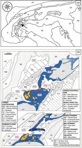
Figure 1. Geographic location and tectonic map of the study area. (a) Tectonic map of the Alps (modified after CitationDal Piaz, Bistacchi, & Massironi, 2003). The arrow indicates the study area. Western (WA) and Eastern (EA) Austroalpine domain; P: Pennidic domain with ophiolites (Oph); Pk: Prealpine klippen; Helvetic-Dauphinois (H-D) domain; Molasse foredeep (M); Jura belt (J); Southern Alps (SA); Pannonian Basin (PB); European (EF) and Po Valley-Adriatic (PA) forelands; Dinaric (DI) and Apenninic (AP) thrust-and-fold belts. (B) Tectonic map (above) and block diagram (below) of the Aosta valley and surrounding areas (modified after CitationDal Piaz et al., 2001). Achronims of tectonic units are explained in the insets.
2. Geological setting
2.1. Western Alps ophiolites
The Western Alps ophiolites are remnants of the oceanic lithosphere and its sedimentary cover, flooring the Mesozoic Tethys ocean which opened between the European and the African passive margins in early Jurassic (CitationStampfli, Marcoux, & Baud, 1991), and are now sutured within the Alpine collisional belt (e.g. CitationDewey, Pitman, Ryan, & Bonnin, 1973; CitationLaubscher, 1971; CitationPolino, Dal Piaz, & Gosso, 1990; see review in CitationMartin, Tartarotti, & Dal Piaz, 1994). They pertain to the Piemonte zone grouping the ophiolitic remnants of the Jurassic Piemonte-Ligurian ocean, which was part of the Western Tethys. The Piemonte zone consists of two main tectonic units, i.e., the Zermatt-Saas and the Combin units, which were defined in Switzerland (CitationBearth, 1967) and then extended to other sectors of the Western Alps (CitationBallevre & Merle, 1993; CitationDal Piaz, 1999; CitationDal Piaz & Ernst, 1978; CitationMichard et al., 1996).
The geological map presented in this paper is located in the southern Aosta Valley (Northwestern Alps, to the south of the Aosta-Ranzola fault system; ) and comprises metamorphic ophiolites, which are comparable to the Zermatt-Saas unit. This unit consists of serpentinite, Fe-Ti- and Mg-metagabbro, metabasalt, covered by metasedimentary rocks showing a dominant early Alpine metamorphic imprint under eclogite-blueschist-facies conditions, partially retrogressed under greenschists facies conditions (e.g. CitationBearth, 1967; CitationBucher et al., 2005; CitationDal Piaz & Ernst, 1978; CitationDal Piaz et al., 1972; CitationErnst & Dal Piaz, 1978; CitationReinecke, 1998; CitationZanoni et al., 2012). Ultra-high pressure conditions for the Alpine metamorphism have been recognized only in oceanic metasediments of the Zermatt-Saas unit in the Valtournanche area (CitationFrezzotti et al., 2011; CitationGroppo et al., 2009; CitationLapen et al., 2003; CitationReinecke, 1998).
The ophiolites cropping out in the southern Aosta Valley are dominated by mantle-derived (now serpentinized) peridotites, intruded by metagabbro and rodingitic dykes; mafic rocks, metatrondjemite, and metasediment comprising metaradiolarite, marble, and flysch-type calcschist occur in minor amounts (CitationMartin & Tartarotti, 1989; CitationNovo, Accotto, Nervo, & Pognante, 1989; CitationTartarotti et al., 1986). Sulphide- and Mn-rich ore deposits are associated with eclogitic to blueschists-facies metabasalt and metasediment exposed in the St. Marcel valley ophiolites (CitationMartin et al., 2008; CitationMartin & Tartarotti 1986; CitationRebay & Powell, 2012; CitationTartarotti & Caucia, 1993; CitationTumiati et al., 2005, Citation2010). These ophiolites show a dominant early Alpine subduction-related metamorphic imprint under eclogite-blueschist-facies conditions, variously retrogressed under greenschists facies conditions (CitationAngiboust & Agard, 2010; CitationBaldelli, Dal Piaz, & Lombardo, 1985; CitationBenciolini et al., 1988; CitationCastelli, 1985; CitationDal Piaz et al., 2001 and refs. therein; CitationMartin & Kienast, 1987; CitationMartin & Tartarotti, 1989; CitationTartarotti & Caucia, 1993).
The ophiolites of the southern Aosta Valley are overthrust by slices of continental crust (i.e. the Mount Emilius, Glacier-Rafray, Tour Ponton, and Acque Rosse tectonic units; see ) attributed to the paleo-African Austroalpine domain (CitationDal Piaz et al., 2001; CitationDal Piaz, Lombardo, & Gosso, 1983; CitationPaganelli, Compagnoni, Nervo, & Tallone, 1994), and showing a comparable Alpine metamorphic evolution (CitationDal Piaz et al., 2001). The geological map here presented mainly comprises serpentinite, metagabbro, and rodingitic dykes overthrust by crustal ophiolitic rocks exposed in the Mount Avic area which are in tectonic contact with the Mt. Glacier Austroalpine klippe ( and ).
2.2. The Mount Avic ophiolite
The ophiolites exposed in the southern Aosta Valley are dominated by a huge (ca. 180 Km2) serpentinite massif bordered by the Fenis-Clavalitè Valley to the West, and by the lower and mid Aosta Valley to the North and East (). Mount Avic is the summit of this massif, reaching an altitude of ca. 3007 m. Serpentinite derives from original mantle peridotites, as suggested by the occurrence of coarse-grained olivine (showing round-shaped and intensely fractured centimetric crystals with intracrystalline deformation attested by the presence of subgrains as well as smaller rounded new grains), Ti-clinohumite, and clinopyroxene, which are reminiscent of original oceanic mantle (CitationFontana, Panseri, & Tartarotti, 2008), and now consisting of antigorite, magnetite, ± chlorite, ± amphibole, ± clinopyroxene, ± Ti-clinohumite, ± olivine (CitationFontana et al., 2008; CitationTartarotti & Martin, 1991). Serpentinite is intruded by Mg-Cr-rich metagabbro (now in tectonic contact with serpentinite) and rodingitic dykes bordered by chloriteschist (CitationPanseri, Fontana, & Tartarotti, 2008). Serpentinite is often mantled by thick ophycarbonate (CitationDriesner, 1993), or serpentinitic breccias (CitationTartarotti, Benciolini, & Monopoli, 1998). The crustal section of the ophiolites in the Mount Avic area crop out along the borders of the serpentinite massif and are better exposed in the nearby Fenis-Clavalitè and St. Marcel valleys (). In these valleys, ophiolites are represented by eclogitic Fe-Ti- and Mg-metagabbro, gabbro-derived metarkose, garnet-bearing glaucophanite rich in pseudomorphed lawsonite and including eclogite boudins, garnet-chloritoid-chloriteschist, and minor talcschist (CitationKrutow-Mozgawa, 1988; CitationMartin et al., 2008; CitationMartin & Tartarotti, 1989; CitationTartarotti, 1988). Estimation of the peak P-T conditions for the St. Marcel valley eclogite provides T = 550–600°C and P = 2.1 - 0.3 Gpa (CitationMartin et al., 2008). These P-T values are lower than those obtained in the Zermatt-Saas s.s. ophiolites which retain HP to UHP conditions for the subduction-related metamorphic peak (see above). Oceanic metasediment associated with ophiolites mostly occurs in the St. Marcel and Champorcher valleys (), and consists of deep sea Mn-Fe-rich metachert, marble and calcschist (CitationTartarotti et al., 1986). The geological map here presented (∼22 km2) was realized in the southern part of the Mount Avic massif where serpentinite is in contact with ophiolitic crustal rocks (mafic rocks and metasediment), in turn overthrusted by the Austroalpine continental crust-derived Mount Glacier klippe (CitationNervo & Polino, 1976).
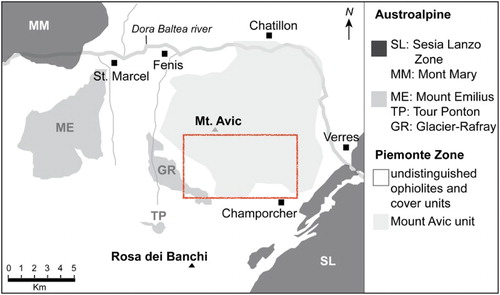
Figure 2. Tectonic map of the southern Aosta valley (modified after CitationNervo & Polino, 1976) with the location of the Mount Avic massif and of the Main Map (red square).
2.3. Lithostratigraphy and structure of the Mount Avic ophiolite
The Mount Avic ophiolite is dominated by serpentinite that consists of massive or foliated to mylonitic rocks with a characteristic ochre- to reddish-brown-coloured coating due to weathering. They are made up of antigorite (>90 vol.%), magnetite (up to mm-sized), Ti-clinohumite, diopside, olivine, chlorite, and amphibole (). Serpentinite encloses rodingitic dykes (up to 2 m-thick and several metres long) bordered by magnetite-rich chloriteschist (), this latter occurring also as isolated layers or lenses inside serpentinite. Various types of rodingite were recognized in the rodingitic dykes (see also CitationPanseri et al., 2008): (a) garnet-rodingitic dyke mainly consisting of garnet (up to 80 vol.%; mainly grossular) and chlorite (20–50 vol.%), with variable amounts of vesuvianite (0–50 vol. %), diopside (0–30 vol.%), magnetite, and rarely titanite, epidote, clinozoisite, and ilmenite; (b) vesuvianite-rodingitic dyke consisting of vesuvianite (50–95 vol.%), chlorite (5–45 vol.%), ± diopside (up to 15 vol.%), ± garnet (often concentrated in veins); (c) pyroxene-epidote dyke consisting of diopside (25–45 vol.%), clinozoisite-zoisite (20–60 vol.%) and chlorite (15–35 vol.%); (d) pyroxene dyke composed by abundant coarse-grained diopside and a small amount of chlorite (less than 5 vol.%). Rodingitic dykes, here exposed, have been interpreted as deriving from seafloor as well as Alpine metamorphism and metasomatic reactions (CitationPanseri et al., 2008). Other metasomatic rocks were observed at the contact between serpentinite and mafic rocks; these reactions zones (to the east of Gran Lac; see the geological map) are marked by reddish-coloured m-sized layers (>50 vol.% Ca-garnet), and green-coloured layers (>50 vol.% epidote). Several bodies of metamorphosed mafic rocks (not rodingitized), ranging from few metres to few hundreds of metres in size, occur as pods inside serpentinite. These rocks are metagabbro, metabasalt, and epidosite. Metagabbro is characterized by coarse-grained flaser tecxture grading to prasinite rich in Ca-amphibole, albite, chlorie, Cr-rich mica, and sulfides. Other mafic rocks rich in Na-amphibole, albite, epidote, and white mica may preserve relict eclogitic minerals (almandine, omphacite, and rutile). Several meters-thick layers of epidosite are infolded within metagabbro in the Lac de Medzove area (western side of the map). Such rocks are characterized by rusty colours and consist of epidote, albite, diopside, amphibole, sulphides, and magnetite. Epidosite layers can be interpreted as the result of hydrothermal fluid circulation within oceanic gabbro. Metasediment is represented by calcschist consisting of white mica, calcite, albite, garnet, and epidote. Metasediment is mainly associated with metagabbro and metabasalt.
Figure 3. Outcrop views in the Mount Avic serpentinite massif. a) foliated serpentinite with serpentine, magnetite, and Ti-clinohumite aligned along the S2 foliation, crenulated by D3 phase (north of Lac Blanc: coord. 389760, 5056352 UTM Z32, ED50). b) Boudinaged rodingitic dyke (rod-dyke) intruded within serpentinite (east of Cote Mouton: coord. 391316, 5056543 UTM Z32, ED50). Dykes are wrapped by chloritic blackwall (chl). c) Outcrop overview with folded rodingitic dykes within foliated serpentinite (east of Cote Mouton: coord. 391300, 5056560 UTM Z32, ED50). d) Close-up of S1 foliated marked by Ti-clinohumite and olivine in sheared serpentinite (north of Lac Blanc: coord. 389760, 5056352 UTM Z32, ED50).
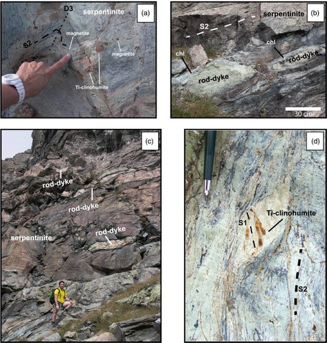
The Main Map is characterized by a regional main ep-amphibolite to greenschist facies foliation S2. S2 foliation is marked by Ca- and Ca-Na- amphibole and chlorite ± epidote in metagabbro, and metabasalt, and by antigorite ± Ca-amphibole ± Ti-clinohumite ± chlorite + magnetite in serpentinite (CitationFontana, 2005). Mafic rocks locally show high pressure S1 foliation marked by garnet + omphacite + rutile and glaucophane (often replaced by winchite and barroisite; CitationFontana, 2005). However S1 is rarely observable to the naked-eye. In serpentinite the S1 foliation is locally visible at the outcrop scale and defined by millimetric-thick ribbons truncated by S2 and consisting of coarse grained clinopyroxene, olivine, Ti-clinohumite, magnetite ± antigorite (see (d); see also CitationFontana et al., 2008 and refers. therein). Olivine, Ti-clinohumite, and clinopyroxene have been attributed by CitationFontana et al. (2008) to original mantle peridotites.
After D1 and D2 deformation phases (responsible to the formation of S1 and S2, respectively), other two folding phases (D3 and D4), which do not generate recrystallization, are recognizable in the Main Map. D3 generally produces metric chevron folds, and locally crenulates the preexisting S2 without developing a new foliation or crystallization of new minerals D4 locally produces metric kink folds with NE-SW trending and steeply dipping axial planes.
Ductile phases are followed by at least four brittle phases, responsible for the development of fractures and faults with E-W, NE-SW, N-S, and NW-SE trends, that are consistent with the regional scale patterns of tectonic lineaments (Aosta-Ranzola-Col de Joux fault, Ospizio Sottile fault, and Simplon fault).
2.4. Quaternary deposits
The Quaternary deposits cover an extensive part of the Main Map. Quaternary deposits are represented on the map as follows: Debris flow and rockfail talus (with rocks up to decimetric), or Boulders (noticeable landslide bodies and detrital fans have been also represented); undistinguished glacial deposits; fluvial deposits; peat bog areas.
3. Method
The map covers an area of roughly 22 km2 and was originally mapped at distinct scales: 1:5000 scale for the portion to the west of the Gran Lac (west of 387855; x coordinate UTM Z32, ED50); 1:10,000 for the portion to the east of the Grand Lac (east of 387855; x coordinate UTM Z32, ED50); and 1:2000 in the Lac de Leser area. The map is here represented at 1:10,000 scale. The topographic map has been vectorialized from the raster version of the Carta Tecnica Regionale (CTR) Valle d'Aosta at the 1:10,000 scale (Tiff files: 86543R, 8658R, 9054R, 9058R, 9454R, 9458R). Original data are stored in a Geographic Information System (GIS) database (coordinate zone 32N, datum ED50, EPSG 23032) and include lithological, petrological, and structural data collected in three Master's Degree theses (CitationBuscemi, 2003; CitationFontana, 2005; CitationPanseri, 2004) and during consecutive studies (CitationFontana et al., 2008; CitationPanseri et al., 2008). A new study concerning the evidence of oceanic mantle exhumation in the Mount Avic ophiolite is still in progress.
The Geological cross-sections have been hand performed and digitalized using a vector graphics editor.
Structural data interpretation is based on geometrical analysis (equal-area lower-hemisphere stereographic projections). D2 (schistogenic), D3, and D4 ductile deformation phases, and four generations of faults and fractures have been plotted. S1 schisotgenic phase is transposed and only locally preserved (see paragraph 1.2).
The final map layout, built by a vector graphics editor, includes the geologic map, a geographic map (CitationRyan et al., 2009), a tectonic sketch map, four representative geological cross-sections, and stereographic projections of the observed structural data.
4. Conclusions
The detailed field mapping between the Fenis-Clavalitè Valley and the lower and mid Aosta Valley area gives extended and updated information on the lithostratigraphy and structure of the Mount Avic ophiolites. The structural relationships between oceanic mantle (serpentinite; mainly exposed on the eastern portion of the map) and crust (metagabbro, metabasite, and calcshist; mainly on the western portion of the map), together with seafloor metamorphism and metasomatic-derived rocks (epidosite and rodingite) cropping out in this area provide an insight to the mantle-crust transition of the Tethyan oceanic lithosphere.
Software
All mapping data have been stored and managed using the open source GIS QGIS 1.9 (CitationQGIS Development Team, 2013). The Geological cross-sections have been digitalized using the open source vector graphics editor Inkscape 0.48 (CitationInkscape Team, 2012). Structural data analysis has been performed using the open source computer software Openstereo (CitationGrohmann & Campanha, 2010). Final map layout has been built using the commercial computer software Adobe® Illustrator® CS6 (CitationAdobe Systems, 2012).
Geological map of the Mount Avic massif (Western Alps Ophiolites)
Download PDF (30.4 MB)Acknowledgments
Funding for this research was provided by P.U.R. grants from the ‘Università degli Studi di Milano’ and grants from ‘Dote ricerca: FSE, Regione Lombardia’. The authors are grateful to Ente Parco Naturale del Mont Avic for logistic supports. We thank John Abraham, Gisella Rebay, and Laura Federico for their valuable comments, which helped to considerably improve the quality of the manuscript.
Related Research Data
References
- Adobe Systems. (2012). Illustrator®. Adobe®. Retrieved from http://www.adobe.com
- Angiboust, S., & Agard, P. (2010). Initial water budget: The key to detaching large volumes of eclogitized oceanic crust along the subduction channel? Lithos, 120(3–4), 453–474. doi:10.1016/j.lithos.2010.09.007
- Baldelli, C., Dal Piaz, G. V., & Lombardo, B. (1985). Ophiolite eclogites from Verres, Val d'Aosta, Western Alps, Italy. Chemical Geology, 50(1–3), 87–98. doi:10.1016/0009–2541(85)90113–5
- Ballevre, M., & Merle, O. (1993). The combin fault: Compressional reactivation of a late cretaceous-early tertiary detachment fault in the Western Alps. In Schweizerische Mineralogische und Petrographische Mitteilungen (Vol. 73, pp. 205–227).
- Bearth, P. P. (1967). Die ophiolithe der zone Von Zermatt-Saas fee. Bern: Kümmerly & Frey.
- Benciolini, L., Lombardo, B., & Martin, S. (1988). Mineral chemistry and Fe/Mg exchange geothermometry of ferrogabbro-derived eclogites from the Northwestern Alps. N Jahrb Mineral Abh, 159, 199–222.
- Bucher, K., Fazis, Y., de Capitani, C., & Grapes, R. (2005). Blueschists, eclogites, and decompression assemblages of the Zermatt-Saas ophiolite: High-pressure metamorphism of subducted Tethys lithosphere. American Mineralogist, 90(5–6), 821–835. doi:10.2138/am.2005.1718
- Buscemi, S. (2003). Le epidositi e i metagabbri ofiolitici del settore meridionale del Monte Avic (Valle d'Aosta): Studio geologico-strutturale e geochimico (Master's Thesis). Università degli Studi di Milano, Milano, Italy.
- Castelli, D. (1985). La Falda Piemontese alla base del margine sudoccidentale del lembo dell'Emilius, media Valle d'Aosta. Ofioliti, 10(1), 19–34.
- Dal Piaz, G. V. (1999). The Austroalpine-Piedmont nappe stack and the puzzle of Alpine Tethys. Memorie di Scienze Geologiche, 51(1), 155–176.
- Dal Piaz, G. V., Bistacchi, A., & Massironi, M. (2003). Geological outline of the Alps. Episodes, 26(3), 175–180.
- Dal Piaz, G. V., Cortiana, G., Moro, A. D., Martin, S., Pennacchioni, G., & Tartarotti, P. (2001). Tertiary age and paleostructural inferences of the eclogitic imprint in the Austroalpine outliers and Zermatt–Saas ophiolite, western Alps. International Journal of Earth Sciences, 90(3), 668–684. doi:10.1007/s005310000177
- Dal Piaz, G. V., & Ernst, W. G. (1978). Areal geology and petrology of eclogites and associated metabasites of the Piemonte ophiolite nappe, breuil—st. Jacques area, Italian Western Alps. Tectonophysics, 51(1–2), 99–126. doi:10.1016/0040–1951(78)90053–7
- Dal Piaz, G. V., Lombardo, B., & Gosso, G. (1983). Metamorphic evolution of the Mt. Emilius klippe, Dent Blanche nappe, western Alps. Am. J. Sci. A, 283, 438–458.
- Dal Piaz, G. V., Martinotti, G., & Hunziker, J. C. (1972). La Zona Sesia-Lanzo e l'evoluzione tettonico-metamorfica delle Alpi nordoccidentali interne. Pisa: Arti Grafiche Pacini Mariotti.
- Dewey, J. F., Pitman, W. C., Ryan, W. B. F., & Bonnin, J. (1973). Plate Tectonics and the Evolution of the Alpine System. Geological Society of America Bulletin, 84(10), 3137–3180. doi:10.1130/0016–7606(1973)84<3137:PTATEO>2.0.CO;2
- Driesner, T. (1993). Aspects of petrographical, structural and stable isotope geochemical evolution of ophicarbonate breccias from ocean floor to subduction and uplift: An example from Chatillon, Middle Aosta Valley, Italian Alps. Schweizerische Mineralogische und Petrographische Mitteilungen, 73(1), 69–84.
- Ernst, W. G., & Dal Piaz, G. V. (1978). Mineral parageneses of eclogitic rocks and related mafic schists of the Piemonte ophiolite nappe, Breuil-St. Jacques area, Italian Western Alps. Am. Mineral, 63(7–8), 621–640.
- Fontana, E. (2005). Evoluzione oceanica e alpina delle serpentiniti del massiccio del Monte Avic (Valle d'Aosta) (Master's Thesis). Università degli Studi di Milano, Milano, Italy.
- Fontana, E., Panseri, M., & Tartarotti, P. (2008). Oceanic relict textures in the Mount Avic serpentinites, Western Alps. Ofioliti, 33(2), 105–118.
- Frezzotti, M. L., Selverstone, J., Sharp, Z. D., & Compagnoni, R. (2011). Carbonate dissolution during subduction revealed by diamond-bearing rocks from the Alps. Nature Geoscience, 4(10), 703–706. doi:10.1038/ngeo1246
- Grohmann, C. H., & Campanha, G. A. (2010). Open stereo: Open source, cross-platform software for structural geology analysis. AGU Fall Meeting Abstracts, IN31C-06.
- Groppo, C., Beltrando, M., & Compagnoni, R. (2009). The P–T path of the ultra-high pressure Lago Di Cignana and adjoining high-pressure meta-ophiolitic units: Insights into the evolution of the subducting Tethyan slab. Journal of Metamorphic Geology, 27(3), 207–231. doi:10.1111/j.1525–1314.2009.00814.x
- Inkscape Team. (2012). Inkscape. Retrieved from http://www.inkscape.org
- Krutow-Mozgawa, A. (1988). Métamorphisme dans les sédiments riches en fer ou magnesium de la couverture des ophiolites piémontaises (mine de Servette, Val d'Aoste) [Metamorphism in the piedmontese ophiolite cover sediment iron and magnesium enriched (mine de Servette, Val d'Aoste)]. (Thèse de 3ème cycle). Université Pierre et Marie Curie, Paris VI, Paris.
- Lapen, T. J., Johnson, C. M., Baumgartner, L. P., Mahlen, N. J., Beard, B. L., & Amato, J. M. (2003). Burial rates during prograde metamorphism of an ultra-high-pressure terrane: An example from Lago di Cignana, western Alps, Italy. Earth and Planetary Science Letters, 215(1–2), 57–72. doi:10.1016/S0012–821X(03)00455–2
- Laubscher, H. P. (1971). The large-scale kinematics of the western Alps and the northern Apennines and its palinspastic implications. American Journal of Science, 271(3), 193–226. doi:10.2475/ajs.271.3.193
- Martin, S., & Kienast, J. R. (1987). The HP-LT manganiferous quartzites of Praborna, Piemonte ophiolite nappe, Italian western Alps. Schweizerische Mineralogische und Petrographische Mitteilungen, 67(3), 339–360.
- Martin, S., Rebay, G., Kienast, J.-R., & Mével, C. (2008). An eclogitised oceanic palaeo-hydrothermal field from the St. Marcel Valley (Italian Western Alps). Ofioliti, 33(1), 49–63.
- Martin, S., & Tartarotti, P. (1986). Geological setting of the Servette-Chuc sulphide glaucophanites, Italian Western Alps. Ofioliti, 11(3), 356–359.
- Martin, S., & Tartarotti, P. (1989). Polyphase HP metamorphism in the ophiolitic glaucophanites of the lower St. Marcel Valley (Aosta, Italy). Ofioliti, 14(3), 135–156.
- Martin, S., Tartarotti, P., & Dal Piaz, G. V. (1994). Alpine ophiolites: A review. Boll. Geof. Teorica Appl, 36, 175–220.
- Michard, A., Goffé, B., Chopin, C., & Henry, C. (1996). Did the Western Alps develop through an Oman-type stage? The geotectonic setting of high-pressure metamorphism in two contrasting Tethyan transects. Eclogae Geologicae Helvetiae, 89(1), 43–80.
- Nervo, R., & Polino, R. (1976). Un lembo di cristallino Dent Blanche alla Torre Ponton (Valle d'Aosta). Bollettino della Societa Geologica Italiana, 95(3–4), 647–657.
- Novo, M., Accotto, S., Nervo, R., & Pognante, U. (1989). Jadeite$\pm$quartz bearing metatrondjemites from the Mt. Nero ophiolitic eclogites, Champorcher valley (western Alps). Ofioliti, 14(1/2), 57–62.
- Paganelli, E., Compagnoni, R., Nervo, R., & Tallone, S. (1994). Il lembo Austroalpino di Eaux Rousses e le sue relazioni con la Zona Ofiolitica Piemontese nell'alta Valle di Cogne, Valle d'Aosta meridionale. Atti convegno Alpi-Appennino, Peveragno, 14, 335–348.
- Panseri, M. (2004). Le rodingiti del Massiccio Serpentinitico del Monte Avic (Valle d'Aosta meridionale): Evidenze dell'evoluzione oceanica e alpina della Zona Ofiolitica Piemontese (Master's Thesis). Università degli Studi di Milano, Milano, Italy.
- Panseri, M., Fontana, E., & Tartarotti, P. (2008). Evolution of rodingitic dykes: Metasomatism and metamorphism in the Mount Avic serpentinites (Alpine Ophiolites, southern Aosta Valley). Ofioliti, 33(2), 165–185.
- Polino, R., Dal Piaz, G. V., & Gosso, G. (1990). Tectonic erosion at the Adria margin and accretionary processes for the Cretaceous orogeny of the Alps. In Mémoires de la Société géologique de France (Vol. 156, pp. 345–367). Presentato al Deep structure of the Alps. Conference, Société géologique de France.
- QGIS Development Team. (2013). Quantum GIS. Retrieved from http://qgis.osgeo.org/
- Rebay, G., & Powell, R. (2012). Eclogite-facies sea-floor hydrothermally-altered rocks: Calculated phase equilibria for an example from the Western Alps at Servette. Ofioliti, 37(1), 55–63.
- Reinecke, T. (1998). Prograde high- to ultrahigh-pressure metamorphism and exhumation of oceanic sediments at Lago di Cignana, Zermatt-Saas Zone, western Alps. Lithos, 42(3–4), 147–189. doi:10.1016/S0024–4937(97)00041–8
- Ryan, W. B. F., Carbotte, S. M., Coplan, J. O., O'Hara, S., Melkonian, A., Arko, R., … Zemsky, R. (2009). Global multi-resolution topography synthesis. Geochemistry, Geophysics, Geosystems, 10(3), n/a–n/a. doi:10.1029/2008GC002332
- Stampfli, G., Marcoux, J., & Baud, A. (1991). Tethyan margins in space and time. Palaeogeography, Palaeoclimatology, Palaeoecology, 87(1–4), 373–409. doi:10.1016/0031–0182(91)90142-E
- Tartarotti, P. (1988). Le ofioliti piemontesi nella media e bassa Valle di St. Marcel (Aosta) (Master's thesis). Università degli Studi di Padova, Padova, Italy.
- Tartarotti, P., Benciolini, L., & Monopoli, B. (1998). Brecce serpentinitiche nel massiccio ultrabasico del Monte Avic (Falda ofiolitica piemontese): Possibili evidenze di erosione sottomarina. Atti Tic Sc Terra, 7, 73–86.
- Tartarotti, P., & Caucia, F. (1993). Coexisting cummingtonite–sodic amphibole pair in metaquartzites from the ophiolite's sedimentary cover (St Marcel Valley, Italian Western Alps): A X-ray structure refinement and petrology study. N. Jahr. Mineral, 165(3), 223–243.
- Tartarotti, P., & Martin, S. (1991). Ultramafic rocks in the Mount Avic eclogitic ophiolites, Italian western Alps. Terra Abstracts, 3, 96–96.
- Tartarotti, P., Martin, S., & Polino, R. (1986). Geological data about the ophiolitic sequences in the St. Marcel Valley (Aosta Valley). Ofioliti, 11(3), 343–346.
- Tumiati, S., Casartelli, P., Mambretti, A., Martin, S., Frizzo, P., & Rottoli, M. (2005). The ancient mine of Servette (Saint-Marcel, Val d'Aosta, Western Italian Alps): A mineralogical, metallurgical and charcoal analysis of furnace slags. Archaeometry, 47(2), 317–340. doi:10.1111/j.1475–4754.2005.00204.x
- Tumiati, S., Martin, S., & Godard, G. (2010). Hydrothermal origin of manganese in the high-pressure ophiolite metasediments of Praborna ore deposit (Aosta Valley, Western Alps). European Journal of Mineralogy, 22(4), 577–594. doi:10.1127/0935–1221/2010/0022–2035
- Zanoni, D., Rebay, G., Bernardoni, J., & Spalla, M. I. (2012). Using multiscale structural analysis to infer high-/ultrahigh-pressure assemblages in subducted rodingites of the Zermatt-Saas Zone at Valtournanche, Italy. Journal of the Virtual Explorer, 41. doi:10.3809/jvirtex.2011.00290