
Abstract
This study presents a geometric and structural analysis of curvilinear sheath folds exposed in blueschist rocks of the Ligurian Alps. Field data are presented in a geological map of the structural synthesis with related geological sections (at the 1:10,000 scale) that illustrate the relationships and evolution of large-scale, sheath folds within metamorphic rocks. We based our analyses on the geometric parameters of more than 40 minor folds, as shape (hinge-Lm1 angle, main axial plane/S1 angle, interlimb angle and hinge curvature), asymmetry, fold hinge/stretching lineation obliquity and structural facing pattern. The summary of the whole data depicts a coherent 3D structure showing several orders of minor folds. Sense of asymmetry of minor folds and stratigraphic order has been used to reconstruct a reliable large-scale structure, and to define the sheath fold shape.
1. Introduction
Geological and structural mapping is a fundamental tool to reconstruct the three-dimensional structure of highly deformed terrains. The relationships among stratigraphy, deformation and metamorphic transformation are efficiently synthesized in geological maps (e.g. in the Ligurian Briançonnais: CitationBrizio et al., 1983; CitationCarminati & Gosso, 2000; CitationMenardi-Noguera, 1988) and a structural synthesis, coherently to the size of the investigated structures (i.e. scale of mapping). Modern mapping of rocks deformed under low-to-medium metamorphic grade includes the description of the meso- and microscopic fabrics, the geometry of folds and faults, shear zones characterization, and the collection of several parameters such as the attitude of foliations, lineation, fold axes, etc. More severe P-T conditions request the description of successive meso- and microscopic fabrics in the form of superposed foliation traces marked by evolving mineral associations (e.g. CitationDelleani, Iole Spalla, Castelli, & Gosso, 2013; CitationRoda & Zucali, 2011).
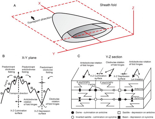
However, in the case of fold structures characterized by highly curvilinear hinge line – i.e. the sheath folds – this approach lacks in defining a reliable, three-dimensional structure. Sheath folds display more than 90° of hinge-line curvature. They may form under different deformation regimes, including general or constriction shear, but are common in non-coaxial deformation dominated by simple shear (see CitationAlsop & Holdsworth, 2006 for a review). At the early stage of deformation, the fold hinges are at high-angle with respect to the transport direction while the stretching lineations are parallel to the same; as deformation increases, the incremental rotation of fold hinges strengthens their curvilinear shape and causes a reversal in the fold hinge/lineation relation with opposing senses on the two limbs of a single folds. It derives that the two limbs of the fold (viewed on the X–Y plane from above) are characterized by clockwise and anticlockwise rotations, which are testified by the minor folds developing along the limb themselves (). Three geometric parameters should be used to describe and map these minor folds: the asymmetry (S, M, Z), the fold facing and the fold hinge/stretching lineation obliquity (CitationAlsop & Holdsworth, 1999, Citation2004; CitationHoldsworth, 1988). The recognition and the systematic collection on the field of these parameters is the unique tool to define the spatial extension of the major folds.
Figure 1. (A) Three-dimensional sketch of a simple sheath fold. (B) Plan of foliation surface (X-Y) showing a schematic pattern of minor folds associated with the major structure. The trace of axial planes, fold facing directions, relationships between the attitudes of fold hinge/stretching lineation and the trace of depressions and culminations with respect the transport direction are indicated. (C) Schematic diagram (Y-Z section view) showing the reversals in facing, minor fold obliquity and asymmetry (S-Z folds) associated with the relative position of axial surfaces and culmination/depression surfaces (modified from CitationAlsop & Holdsworth, 1999).
In this paper, we present a wide collection of geometric data from minor sheath folds that characterize the blueschist facies Bormida Unit of the Briançonnais in the Ligurian Alps (. CitationSeno, Dallagiovanna, Gaggero, Felletti, & Pellegrini, 2010). These data have been summarized in a geological map (Main Map), a structural sketch, relative cross-sections and stereo plots. The reconstructed geometrical framework allows us to define the three-dimensional structure of a major sheath fold forming the Bormida Unit.
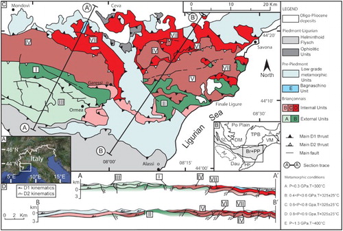
Figure 2. (A) Relief map of the study area. (B) Regional structural sketch highlighting the location of the palaeogeographic domains of the Ligurian Alps. A - Apennines; Ar - Argentera; Br - Briançonnais; Dau - Dauphinois; DM - Dora-Maira; HF - Helminthoid Flysch; PP - Pre-Piedmont; SL - Schistes Lustrés; TPB - Tertiary Piedmont Basin; VM - Voltri Massif. (C) Structural map of the Ligurian Alps. Roman numbers indicate the Briançonnais units: I - Internal Ormea; II - Monte Carmo; III - External Ormea; IV - Mallare; V - Settepani; VI - Bormida; VII - Pamparato-Murialdo. (D) Regional sections.
2. Methods
The Bormida Unit is characterized by easily distinguishable lithologies and the displaying of a variety of minor structures, which offer the rare opportunity to map the geological boundaries with a good confidence, and to collect a great amount of structural data. Moreover, geometric parameters of more than 40 minor folds have been collected and measured.
The field data have been represented in a geological map (Main Map) and a structural sketch both at the 1:10,000 scale. The topographic base map is the ‘Carta Tecnica Regionale Regione Liguria’, scale 1:10,000. The geological map displays the outcrops distribution of the lithologies and the main structural data, such as the trace of thrusts and faults, the attitude of foliations and the plunge of the stretching lineations (indicated by mineral aggregates). All rocks are described and mapped on the basis of their mineral composition and classified in correlation with previous fieldwork performed in the study area (CitationSeno et al., 2010). The relative chronology of the two recognized metamorphic foliations (i.e. S1 and S2) is inferred from the classic overlapping structural correlation criteria, both at meso- and microscopic scale. The interpretative map derives from the integration of all stratigraphic and structural data.
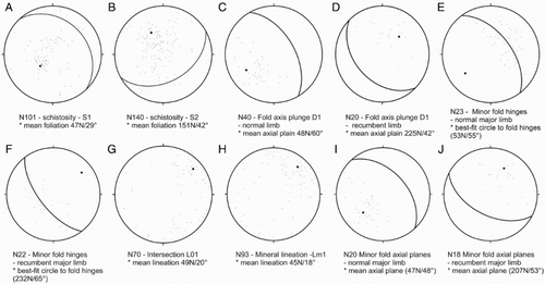
The structural synthesis contains complementary information about the spatial trend of the minor sheath folds. These data are: (1) trace of axial planes, (2) fold facing directions, (3) relationships between the attitude of fold hinge/lineation, and (4) trace of depressions and culminations. All of these data are synoptically represented of the three parameters collected during the fieldwork. The first parameter is the asymmetry, conventionally described as the long-limb/short-limb relationships (Z, S and M folds; ). The systematic mapping of these asymmetries defines the fold axial traces (CitationAlsop & Holdsworth, 1999). The change in sense of minor fold asymmetry along the strike of the axial plane and the associated schistosity is a crucial indicator of the spatial development of syn- or antiformal folds. Relationships between stratigraphy and geometry define not only the further distinction between synclines and anticlines, but also on the fold facing. Fold facing is defined as the direction, normal to the fold hinge, along the fold axial plane, and toward the younger beds (CitationHoldsworth, 1988). Because of the sheath folds are characterized by highly curvilinear hinges, the fold facing pattern results in a wide arc of directions, strictly related to their position within the fold (). In our structural sketch we show the main directions of fold facing respect to the trace of the axial planes.
As a third parameter to define the sheath fold structure, we use the angular relationship between the fold hinge and stretching lineations, which is described as clockwise or anticlockwise (when viewed on the axial, X-Y, plane from above; CitationAlsop & Holdsworth, 2006; ). As a consequence, the sheath folds have been distinguished on the basis of their symmetry or asymmetry with respect two orthogonal mirror planes centered along X-Y axial surface and X-Z medial surface (culmination/depression) which bisects the fold nose (CitationAlsop & Holdsworth, 2004). Curvilinear folds are thus classified into the structural sketch in either synform-depression or antiform-culmination closing structures which are bisected by the mineral/stretching lineation (Lm1; ).
The collection of these parameters allows one to distinguish the three-dimensional spatial distribution of the minor folds along the limbs of the major sheath fold. The integration of these data resulted thus into two interpretative sections across the major sheath fold constituting the Bormida Unit.
3. Geological setting
The Ligurian Alps form an E-W-oriented mountain chain located at the junction between two arched orogenic belts: the Western Alps and the Apennines (CitationMaino, Decarlis, Felletti, & Seno, 2013; CitationVanossi et al., 1986; ). They are formed by a series of imbricated tectonic units derived from three adjacent paleogeographical domains. The Briançonnais and Prepiedmont domains represent the European continent and its margin, respectively, while the Piedmont-Ligurian is comprised of the oceanic crust (CitationDecarlis, Dallagiovanna, Lualdi, Maino, & Seno, 2013; ). As a consequence of the convergence and subsequent collision of the European and Adria plates, during the Eocene/Early Oligocene times, these rocks experienced a poliphase deformation history comparable with other sector of the Western alps (e.g. CitationCarminati et al., 1998; CitationGidon, 1972; CitationPlatt & Lister, 1985): a pro-thrusting phase (D1, SW-vergent), and an ensuing back-thrusting phase (D2, NE-vergent) (CitationBonini, Dallagiovanna, & Seno, 2010; CitationSeno, 1992; CitationSeno, Dallagiovanna, & Vanossi, 1998, Citation2003, Citation2005). These deformation phases are associated with a mix of metamorphic and non-metamorphic slices juxtaposed tectonically along thrusts exhumed from the subduction channel or the orogenic wedge (peak-metamorphic conditions are listed in ).
Subsequent Oligo-Miocene deformation phases (D3-D5) are characterized by trantensional/transpressional fault systems (CitationMaino, Dallagiovanna, Dobson 2012; CitationMaino et al., 2013).
In this work we focus on the Bormida Unit, which is a relative small nape belonging to the inner Briançonnais domain (). It shows a very reduced Late Permian-Cretaceous stratigraphic succession (CitationSeno et al., 2010) characterized by HP/LT blueschist facies metamorphism associated with the development of an early (S1) schistosity (related to the D1 phase). A second metamorphic foliation (S2, D2-related) occurred under greenschist facies metamorphism.
4. Stratigraphy and metamorphism
4.1. Lithologic types
The Bormida Unit consists of Late Permian high-K alkaline rhyolites (Melogno Porphyroids -Lithozone D) and conglomerates (Monte Pianosa Formation), Early Triassic quartzite (Ponte di Nava Quartzites), Jurassic limestone (Val Tanarello Formation) and Late Cretaceous calcareous schist (Caprauna Formation). The formational names derive from the Italian Geological Map covering the study area (Foglio 228 – Cairo Montenotte, CitationSeno et al., 2010).
The D Lithozone is massive, green colored rhyolites with high modal K-feldspar within a glassy groundmass. It is pervasively schistose and the ignimbritic textures are hardly recognizable; it reaches up to 300 m in thickness, in some places eroded by the overlying Verrucano. Fine-to-medium grained (0.5–5 mm) K-feldspar phenoclasts prevail over quartz. Biotite is rare, but there is abundant ilmenite, zircon and apatite. The groundmass is green due to secondary phengite. Ankerite nodules, probably corresponding to present-day caliches, most likely mark pristine paleosoils. These rhyolites are dated to 258.5±2.8 Ma (U-Pb zircon dating, CitationDallagiovanna, Gaggero, Maino, Seno, & Tiepolo, 2009). They are truncated by an eroded surface at the base of the lowermost Permian conglomerates (Monte Pianosa Formation). These last (classically referred as ‘Briançonnais Verrucano’, CitationVanossi et al., 1986) are constituted by polygenic well-rounded conglomerates and embedded green and violet schists grading to Early Triassic quartzites (Ponte di Nava Quartzite) characterized by coarse-grained gray quartzarenites. The total thickness of conglomerates and Verrucano varies from 40 to 90 m (CitationDecarlis et al., 2013). These Late Permian-Early Triassic molasse is covered by well-bedded light gray limestone of the Late Permian Val Tanarello Formation for a total thickness up to 100 m. It results that the Middle Triassic-Middle Jurassic succession is completely absent, highlighting a wide sedimentary gap typical of the inner sector of the Briançonnais domain (CitationDecarlis et al., 2013). The stratigraphic succession ends with the Late Cretaceous emipelagic limestone of the Caprauna Fromation, known in all the Western Alps with the term of ‘Calcschistes planctoniques’ (e.g. CitationVanossi et al., 1986).
The other units exposed in the study area are the Mallare Unit, which includes Variscan basement and fluvial-lacustrine deposits (CitationMaino, Dallagiovanna, Gaggero, Seno, & Tiepolo, 2012), the Pamparato-Murialdo Unit – made of Early Permian ignimbrites and alluvial sediments – and the Settepani Unit consisting of only Permian volcanites (CitationSeno et al., 2010).
4.2. Petrographic features of the Bormida unit
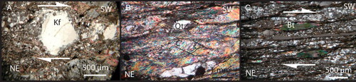
The Late Permian-Mesozoic rocks of the Bormida unit are affected by two main metamorphic foliations. The most suitable lithologies for the petrographic analysis are the Late Permian volcanites (Melogno Porphyroids -Lithozone D). The rhyolites show S1-lying paragenesis characterized by Albite + Na- amphibole + Na-Ca clinopyroxen + Pumpellyite + Chlorite + Titanite assemblages. The S2 foliation is characterized by albite + chlorite aggregates which are the result of the destabilization of the Na amphibole. These data, integrated with the studies carried out in neighboring units (CitationDallagiovanna, Seno, & Vanossi, 1997), indicate that the D1 event developed under HP/LT conditions (P ≈ 0.9 GPa and T= 325±25 °C) associated with a blueschist facies, while the D2 event recorded decompression under greenschist facies (P<0.55 GPa and T= 325±25 °C).
5. Structure of the Bormida unit
The detailed geological mapping of the study area shows a thrust surface coupling the Pamparato-Murialdo meta-sediments and volcanites onto the Late Permian-Mesozoic rocks of the Bormida Unit. Kinematic indicators of thrust fault zones show outward (SW) transport direction, typical of all the D1 in the Ligurian Alps (CitationBonini et al., 2010; CitationDallagiovanna et al., 1997; CitationSeno et al., 2003).
To the South, the Settepani Unit overlies both the Pamparato-Murialdo and Bormida units through over thrusts faults with an inward-directed transport (∼N) associated with the S2 foliation. The Mallare Unit holds the deepest and geometrically lower position. Both the pro- and back-thrusts cut the folded structures recognized in the Bormida succession ().
The structure of the Bormida unit is dominated by tight to isoclinal folds that can be observed at all scales and in all lithologies (). A well-developed axial plane schistosity (S1) is associated with folding. S1 foliation steeply dips mainly toward NE (). Mainly NE-plunging (and minor SW-plunging) stretching lineations (Lm1; indicated by mineral aggregates) are defined by quartz pebbles in the conglomerates or by elongated k-feldspars in the rhyolites. All over the mapped area, Lm1 are slightly deflected by later deformational events as indicated by the dispersion of poles (). The relationship between D1 folds and thrusts appears to be diachronic. The thrust surfaces, in fact, cut the folds () suggesting that the thrusting event (D1t) followed the folding phase (D1f). A second generation of folds appear as open to tight folds, with NE-plunging axes. The associated foliation (S2, mainly SE-dipping; ) is characterized by fracture cleavage in limestone and strain-slip cleavage in the volcanites and conglomerates. In the calcareous schists the S1 foliation is completely transposed onto the S2 planes.
Figure 3. D1 cat-eye-sheath fold within Jurassic limestones and Cretaceous schists. The Pamparato-Murialdo basal thrust surface cuts the fold.
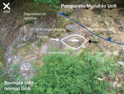
Figure 4. Cat-eye-sheath fold within Late Permian Rhyolites (Melogno Porphyroids – D Lithozone).
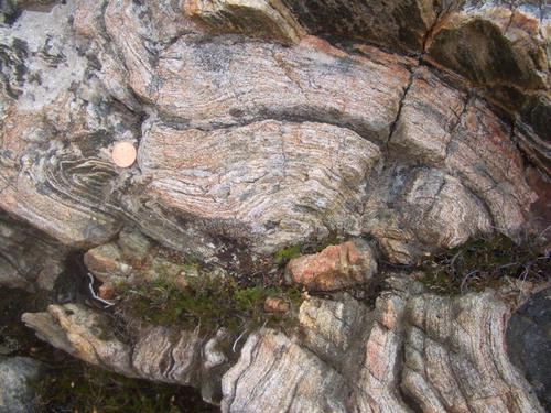
Figure 5. Detail (plane view) of the closure of a cat-eye-sheath fold within Late Permian Rhyolites (Melogno Porphyroids – D Lithozone).
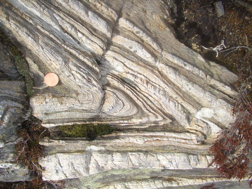
Figure 6. Stereographic projections (Schmidt equal area diagrams) of the main spatial attributed collected in the fieldwork. N indicate the number of measurements. The mean great circle and the relative pole are shown with a tick line and point, respectively.
More than 40 minor D1 folds mapped in the Bormida unit can be classified as sheath folds on the basis of their geometrical features. They display hinges at low angles with the shear direction (hinge-Lm1 angle = θ = ∼30°), fold axial planes and the associated hinge-girdle planes sub-parallel to the foliation (main axial plane/S1 angle = ω = ∼14°), together with extremely tight interlimb angles (α = ∼12°). In sectional view (x-z plain; , 3–5), folds with pronounced curving hinge lines (hinge curvature = δ > 160°) are marked by eye-fold closures. In general, the geometrical features of the Bormida folds depict a fold shape typical of mature sheath folds. Most of the recognized minor folds show a typical tubular shape (CitationSkjernaa, 1989) with an interlimb angle (α) < 20° and a x/y ratio > 1.
The structural synthesis shows the trace of major synclines and anticlines derived from the integration of the field-data collected for each minor fold. The parameters are: the orientation of minor fold hinges relative to the adjacent Lm1 mineral/stretching lineations, the direction of fold facing and the position of the S, M and Z minor folds (). For the purposes of structural analysis, curvilinear folds are simply classified into either N-E (synform-depression) or S-W (antiform-culmination) closing structures which are typically bisected by the SW trending stretching lineation (Lm1). Moreover, the younging direction is derived from the stratigraphy. Thus, the folds are further differentiated as anticlines and synclines. Along the X-Z surface, the anticlinal-antiform and synclinal-synform are in the normal limb, whereas the anticlinal-synform and synclinal-antiform lie on the recumbent fold. The collected data are synthetically reported in the structural synthesis, where the Bormida unit resulted divided into two parts: a south-western portion characterized by a normal limb geometry and a north-eastern sector, characterized by a recumbent fold geometry. In the normal limb, the fold hinges collectively define a well-developed fold hinge girdle, plunging toward the NE, which extends over an arc of ∼140°, parallel to the associated mean axial plane. The same geometry is present for the recumbent fold, but with opposite orientation (SW). The normal limb preserves a tectonically, advanced position respect to the recumbent limb.
The three-dimensional interpretation of the sheath folds characterizing this unit is shown into two cross-section parallel (A-A’) and perpendicular (B-B’) to the tectonic transport direction.
The main NE-SW direction of the Lm1 is in agreement with the regional SW-vergence of the D1 structures (CitationBonini et al., 2010). Several kinematic indicators within the multi-scale shear zones (S-C and S-C’ systems, δ and σ structures around rotated porphyroblastes and mica-fish; ) indicate a constant ‘top to the SW’ sense of shearing with an apparently dominating simple shear component of the D1 deformation (CitationPasschier & Trouw, 1995). However, strain analysis and numerical simulation (CitationMenardi Noguera, 1988; CitationSeno et al., 1998) in sheath folds of neighboring Briançonnais units (Armettaand Mallare units) indicate that the generation of curvilinear sheath folds occurred at lower values of shear strain (γ<2) with respect simple shear regime, which needs γ values ≥ 5. A value of γ < 2 was obtained from the sheath folds in the Armetta and Mallare units, which indicates a general non-coaxial flow associated with a regional component of pure shear. Prolate finite strain associated with apparent constriction are recorded in the noses of these kilometric sheath folds while the limbs are marked by oblate strain indicative of apparent flattening. The style of deformation and strain regime derived from the strain analysis from these Briançonnais units are in agreement with our geometrical parameters and the cats-eye shape shown by the sheath folds in the Bormida Unit. These data suggest that the basic observation of sigma/delta-type objects is not a reliable indicator of exclusive simple shear regime.
Figure 7. Microstructures. (A) δ structure around a rotated K-felspar porphyroblast; (B) S-C’ systems and δ structures around quartz porphyroblastes; (C) biotite mica-fish. All these microstructures indicate a dextral (‘top to SW’) sense of shearing.
The deformation style of the Ligurian Briançonnais described in this work is comparable to other areas distributed in the Western Alps, such as structures observed in the Vanoise massif (Dent Parrachée nappe; CitationDe Roo & Lister, 1987; CitationPlatt & Lister, 1985), CitationMonte Rosa nappe (Lacassin and Mattauer, 1985) and Corsica (CitationHarris, 1985), confirming the occurrence of recurrent deformation pattern along all the Alpine orogenic belt.
6. Conclusion
The whole of geological features and geometrical measurements collected during a detailed fieldwork in the Briançonnais Bormida Unit have been synthetically reported into a geological map and a structural sketch (1:10,000 scale). Geological maps and sections have been the main tool to define the structure of the study area associated with the development of sheath folds. A variety of lithologies and a good exposition of minor folds allowed to investigate the relationships between stratigraphy and deformation and to derive a realistic geological interpretation of the area. Finally, our study presents an application of the structural mapping technique developed by CitationAlsop and Holdsworth (1999), CitationAlsop and Holdsworth (2004), CitationAlsop and Holdsworth (2006) and CitationAlsop and Carreras (2007) in areas where sheath folds are dominant. Although applied by these Authors in some places around the word (e.g. Spain, Ireland and Scotland), such methodology and the derived cartographic representation has been rarely performed, especially in the Alps.
Software
The geological map was compiled using ARCGIS 10.0 (ESRI) and refined using Adobe Illustrator. Sections were constructed using Adobe Illustrator. Stereonet plots were computed using Stereonet (CitationAllmendinger, 2011).
Large sheath folds in the Briançonnais of the Ligurian Alps reconstructed by analysis of minor structures and stratigraphic mapping
Download PDF (4.4 MB)Acknowledgement
The research was supported by Italian 1:50.000 Geological Mapping (CARG – Regione Liguria Project, University of Pavia) grants.
Related Research Data
References
- Allmendinger, R. (2011) Stereonet 8 for Windows [Online]. Retrieved from: http://www.geo.cornell.edu/geology/faculty/RWA/programs/stereonet.html
- Alsop, G. I., & Carreras, J. (2007). The structural evolution of sheath folds: A case study from Cap de Creus. Journal of Structural Geology, 29, 1915–1930. doi: 10.1016/j.jsg.2007.09.010
- Alsop, G. I., & Holdsworth, R. E. (1999). Vergence and facing patterns in large-scale sheath folds. Journal of Structural Geology, 21, 1335–1349. doi: 10.1016/S0191-8141(99)00099-1
- Alsop, G. I., & Holdsworth, R. E. (2004). The geometry and topology of natural sheath folds: a new tool for structural analysis. Journal of Structural Geology, 26, 1561–1589. doi: 10.1016/j.jsg.2004.01.009
- Alsop, G. I., & Holdsworth, R. E. (2006). Sheath folds as discriminators of bulk strain type. Journal of Structural Geology, 28, 1588–1606. doi: 10.1016/j.jsg.2006.05.005
- Bonini, L., Dallagiovanna, G., & Seno, S. (2010). The role of pre-existing faults in the structural evolution of thrust systems: Insights from the Ligurian Alps (Italy). Tectonophysics, 480(1–4), 73–87. doi: 10.1016/j.tecto.2009.09.021
- Brizio, D., Deregibus, C., Eusebio, A., Gallo, M., Gosso, G., Rattalino, E. Rossi, F., Tosetto, S., & Oxilia, M. (1983). Guida all'escursione: i rapporti tra la zona Brianzonese Ligure e il Flysch a Elmintoidi, Massiccio del Marguareis (Limone Piemonte–Certosa di Pesio, Cuneo, 14/15 Settembre 1983). Memorie della Società Geologica Italiana, 26, 579–595.
- Carminati, E., & Gosso, G. (2000). Structural map of a Ligurian Briançonnais cover nappe (Conca delle Carsene, Monte Marguareis, Ligurian Alps, Italy) and explanatory notes. Mem. Sci. Geol. Padova, 52, 93–99.
- Carminati, E., Wortel, M. J. R., Spakman, W., & Sabadini, R. (1998). The role of slab detachment processes in the opening of the western-central Mediterranean basins: Some geological and geophysical evidence. Earth and Planetary Scinces Letters, 160 (3–4), 651–665.
- Dallagiovanna, G., Gaggero, L., Maino, M., Seno, S., & Tiepolo, M. (2009). U-Pb zircon ages for post-Variscan volcanism in the Ligurian Alps (Northern Italy). Journal of the Geological Society, London, 166, 1–14. doi: 10.1144/0016-76492008-027
- Dallagiovanna, G., Seno, S., & Vanossi, M. (1997). An example of the Alpine structural evolution of the Penninic zone in the Ligurian Alps: Tectonics of the Barbassiria area. Eclogae geol. Helv., 90, 337–344.
- Decarlis, A., Dallagiovanna, G., Lualdi, A., Maino, M., & Seno, S. (2013). Stratigraphic evolution in the Ligurian Alps between Variscan heritages and the Alpine Tethys opening: A review. Earth-Science Reviews, 125, 43–68. doi: 10.1016/j.earscirev.2013.07.001
- Delleani, F., Iole Spalla, M., Castelli, D., & Gosso, G. (2013). A new petro-structural map of the Monte Mucrone metagranitoids (Sesia-Lanzo Zone, Western Alps). Journal of Maps, 9(3), 410–424. doi: 10.1080/17445647.2013.800004
- De Roo, J. A., & Lister, G. S. (1987). Deformation of a thrust complex in the Col de la Vanoise, Vanoise Massif, French Alps. Geological Society of America Bulletin, 98(4), 388–39. doi: 10.1130/0016-7606(1987)98<388:DOATCI>2.0.CO;2
- Gidon, M. (1972). Les chaînons briançonnais et subbriançonnais de la rive gauche de la Stura entre le Val de l'Arma (province de Cuneo Italie). Géologie Alpine, 48, 87–120.
- Harris, L. (1985). Progressive and polyphase deformation of the Schistes Lustré in Cap Corse, Alpine Corsica. Journal of Structural Geology, 7, 637–650. doi: 10.1016/0191-8141(85)90140-3
- Holdsworth, R. E. (1988). The stereographic analysis of facing. Journal of Structural Geology, 10, 219–223. doi: 10.1016/0191-8141(88)90119-8
- Lacassin, R., & Mattauer, M. (1985). Kilometre-scale sheath fold at Mattmark and implications for transport direction in the Alps. Nature, 315, 739–742. doi: 10.1038/315739a0
- Maino, M., Dallagiovanna, G., Dobson, K. J., Gaggero, L., Persano, C., Seno, S., & Stuart, F. M. (2012). Testing models of orogen exhumation using zircon (U-Th)/He thermochronology: Insight from the Ligurian Alps, Northern Italy. Tectonophysics, 560–561, 84–93. doi: 10.1016/j.tecto.2012.06.045
- Maino, M., Dallagiovanna, G., Gaggero, L., Seno, S., & Tiepolo, M. (2012). U-Pb zircon geochronological and petrographic constraints on late to post-collisional Variscan magmatism and metamorphism in the Ligurian Alps, Italy. Geological Journal, 47(6), 632–652. doi: 10.1002/gj.2421
- Maino, M., Decarlis, A., Felletti, F., & Seno, S. (2013). Tectono-sedimentary evolution of the Tertiary Piedmont Basin (NW Italy) within the Oligo-Miocene central Mediterranean geodynamics. Tectonics, 32(3), 593–619. doi: 10.1002/tect.20047
- Menardi-Noguera, A. (1988). Structural evolution of a Brianconnais cover nappe, the Caprauna-Armetta unit (Ligurian Alps, Italy). Journal of Structural Geology, 10, 625–637. doi: 10.1016/0191-8141(88)90028-4
- Passchier, C. W., & Trouw, R. A. J. (1995). Microtectonics, 2nd ed. Heidelberg: Springer Verlag. 366 pp.
- Platt, J. P., & Lister, G. S. (1985). Structural evolution of a nappe complex, southern Vanoise Massif. French Pennine Alps. Journal of Structural Geology, 7, 145–160. doi: 10.1016/0191-8141(85)90128-2
- Roda, M., & Zucali, M. (2011). Tectono-metamorphic map of the Mont Morion Permian metaintrusives (Mont Morion—Mont Collon—Matterhorn Complex, Dent Blanche Unit). Valpelline—Western Italian Alps, Journal of Maps, 7(1), 519–535.
- Seno, S. (1992). Finite strain and deformation within the Briançonnais Castelvecchio-Cerisola nappe of the Ligurian Alps, Italy. Journal of Structural Geology, 14, 825–838. doi: 10.1016/0191-8141(92)90043-V
- Seno, S., Dallagiovanna, G., Gaggero, L., Felletti, F., & Pellegrini, L. (2010). Cairo Montenotte - 228 Sheet, Geological Map of Italy, 1:50.000 scale, ISPRA, Rome, Italy. Retrieved from http://www.isprambiente.gov.it/Media/carg/228_CAIRO_MONTENOTTE/Foglio.html
- Seno, S., Dallagiovanna, G., & Vanossi, M. (1998). From finite strain data to strain history: a model for a sector of the Ligurian Alps, Italy. Journal of Structural Geology, 20(5), 573–585. doi: 10.1016/S0191-8141(97)00104-1
- Seno, S., Dallagiovanna, G., & Vanossi, M. (2003). Palaeogeography and thrust development in the Penninic domain of the Western Alpine chain: Examples from the Ligurian Alps. Bollettino della Societa Geologica Italiana, 122(2), 223–232.
- Seno, S., Dallagiovanna, G., & Vanossi, M. (2005). A kinematic evolution model for the Penninic sector of the central Ligurian Alps. International Journal of Earth Sciences, 94, 114–129. doi: 10.1007/s00531-004-0444-1
- Skjernaa, L. (1989). Tubular folds and sheath folds: definitions and conceptual models for their development, with examples from the Grapesvare area northern Sweden. Journal of Structural Geology, 11, 689–703. doi: 10.1016/0191-8141(89)90005-9
- Vanossi, M., Cortesogno, L., Galbiati, B., Messiga, B., Piccardo, G. B., & Vannucci, R. (1986). Geologia delle Alpi Liguri: dati, problemi, ipotesi. Memorie della Società Geologica Italiana, 28, 5–75.