
Abstract
The External Ligurian and Epiligurian Units in the Northern Apennines of Italy are tectonically juxtaposed with the Tertiary Piedmont Basin along the Villalvernia – Varzi Line, which represents a regional scale fault zone, E-striking. Our map, at the 1:20,000 scale, describes the tectono-stratigraphic evolution of this sector that resulted from multistage faulting along that fault zone. Four main tectonic stages are defined on the basis of the crosscutting relationships between mapped faults and stratigraphic unconformities: late Priabonian – Rupelian, Chattian – early Miocene, late Serravallian – Tortonian, and late Messinian – early Pliocene. Our results demonstrate that since the late Burdigalian, the Villalvernia – Varzi Line was sealed by the gravitational emplacement of a chaotic rock body. The deposition of the late Serravallian – early Messinian succession is controlled by NW-striking strike-slip faults that crosscut to the west the Villalvernia – Varzi Line. Extensional tectonics related to regional scale N-dipping tilting characterized the late Messinian – early Pliocene time interval.
1. Introduction
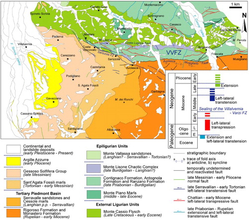
The Villalvernia – Varzi Line () is an E-striking and steeply dipping regional fault zone, separating the External Ligurian Units and Epiligurian Units of the Northern Apennines, to the North, from the Tertiary Piedmont Basin, to the South. It has controlled the early Oligocene – Miocene tectono-sedimentary evolution of this area (e.g. CitationBoni, 1961; CitationDi Giulio & Galbiati, 1995; CitationFelletti, 2002; CitationGelati, Bruzzi, Catasta, & Cattaneo, 1974; CitationGhibaudo, Clari, & Perello, 1985; CitationMosca, Polino, Rogledi, & Rossi, 2010; CitationMutti et al., 1995), and played also a significant role in the westward-indentation of the Adria microplate (i.e. part of the African plate) with the Western Alpine belt (see also CitationCastellarin, 1994; CitationLaubscher et al., 1992; CitationMosca et al., 2010 and reference therein). Moreover, the sector South of the Villalvernia-Varzi Line (i.e. the Borbera Grue zone of the Tertiary Piedmont Basin) represents one of the few seismic sectors of the Piedmont Region in NW Italy as shown by recent seismic events (CitationINGV, 2007) that caused significant damage to local population and facilities (e.g. 4,6 MI event of Sant'Agata Fossili in Spring 2003; see CitationINGV, 2007).
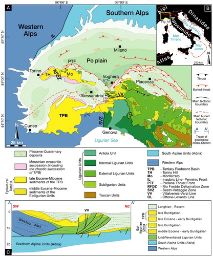
Figure 1. Structural sketch map (A) of northwestern Italy (modified from CitationBigi, Cosentino, Parotto, Sartori, & Scandone, 1983; CitationCodegone et al., 2012; CitationMosca et al., 2010). (B) Location of (A) (modified from CitationVezzani, Festa, & Ghisetti, 2010) and (C) Regional-scale geological cross-section showing the buried structure of the Villalvernia – Varzi Line (location in (A); modified from CitationMosca et al., 2010).
Therefore, a detailed geological mapping of this regional tectonic ‘Line’ is of societal significance and important to better understand the tectono-stratigraphic evolution of the Northern Apennines and Tertiary Piedmont Basin. The existing geological cartography mainly consists of regional scale maps (e.g. CitationBoccaletti, 1982; CitationBoni, 1969a, Citation1969b; CitationCerrina Feroni, Ottria, Martinelli, & Martelli, 2002) and of only few detailed maps that cover either parts of this area (e.g. CitationCavanna et al., 1989; CitationVercesi et al., in press) or are limited to the Tertiary Piedmont Basin units to the South of the Villalvernia – Varzi Line (CitationGhibaudo et al., 1985; CitationMarroni et al., in press).
We present a new geological map, at the 1:20,000 scale (see Main Map), of the central and western sector of the Villalvernia-Varzi Line (between Scrivia and Curone valleys). The studied sector is crucial for better understanding the multistage tectonic evolution of this ‘Line’ and its geological control on the Oligocene – Miocene tectono-sedimentary evolution in this area located in between the Northern Apennines and the Tertiary Piedmont Basin.
2. Methods
The geological map was created given data collection over an eight-year period (2006–2013) of field-work at the 1:10,000 scale and accompanying detailed stratigraphic and structural analyses. The definition of the complex structural setting of the sector was defined through the mapping of the crosscutting relationships between main thrust faults and tectonically driven stratigraphic unconformities that are documented in the attached geological map at 1:20,000 scale (see Main Map), using the topographic map ‘CTR – Carta Tecnica Regionale, Regione Piemonte’.
The map was ultimately created using the methodological cartographic and representative criteria from the CARG Project (Project of Geological Cartography), at the 1:50,000 scale (see CitationPasquarè et al., 1992a, Citation1992b). Cartography of pre-Quaternary sedimentary substratum is based on lithostratigraphic criteria (see CitationGermani, Angiolini, & Cita, 2003; CitationPasquarè et al., 1992a, Citation1992b), which differentiate lithostratigraphic units and unconformity surfaces, bounding different synthems. Faults characterized by multistage reactivation have been represented according to the observed kinematics of the main displacement.
3. Regional setting
The Northern Apennines () record the complex evolution from the Late Cretaceous subduction phase to the Cenozoic continental collision between the European plate and the Adria microplate (Africa plate), and subsequent intra-continental deformations (e.g. CitationCavazza, Roure, & Ziegler, 2004; CitationCoward & Dietrich, 1989; CitationElter, Grasso, Parotto, & Vezzani, 2003; CitationFesta, Dilek, Codegone, Cavagna, & Pini, 2013; CitationMarroni, Meneghini, & Pandolfi, 2010). Since the middle-late Eocene, episutural (i.e. Tertiary Piedmont Basin) and wedge-top (i.e. Epiligurian Units) basins were developed to the South and North of the E-striking proto-Villalvernia – Varzi Line (), respectively (e.g. CitationBiella et al., 1997; CitationMutti et al., 1995; CitationRicci Lucchi, 1986). The episutural Tertiary Piedmont Basin ((A)) consists of a late Eocene – late Messinian succession and is unconformably deposited on both Alpine metamorphic rocks and Apennine Ligurian units (see ‘Ligurian knot’ of CitationLaubscher et al., 1992; CitationSchumacher & Laubscher, 1996; see also CitationBiella, Gelati, Lozej, Rosisi, & Tabacco, 1988, Citation1997; CitationCastellarin, 1994; CitationFesta et al., 2005, Citation2009, 2013; CitationLaubscher et al., 1992; CitationMosca et al., 2010; CitationMutti et al., 1995; CitationPiana, 2000; CitationRoure, Bergerat, Damotte, Mugnier, & Polino, 1996). It is subdivided in the Tertiary Piedmont Basin s.s. (sensu stricto) to the South (i.e. Langhe, Alto Monferrato and Borbera-Grue), and the Monferrato –Torino Hill to the North. The wedge-top basins of the Epiligurian Units (piggy-back basin sensu CitationOri & Friend, 1984), middle Eocene – late Miocene in age, unconformably overlain the External Ligurian Units of Northern Apennines (e.g. CitationMutti et al., 1995; CitationRicci Lucchi, 1986; CitationRicci Lucchi & Ori, 1985).
On the opposite sides of the Villalvernia – Varzi Line (), the stratigraphic successions started to differentiate from the middle – late Rupelian (CitationDi Giulio & Galbiati, 1995; CitationGelati et al., 1974; CitationMosca et al., 2010; CitationMutti et al., 1995), temporally constraining early tectonics. Left-lateral movements, proposed to continue up to the Pliocene time (CitationGelati et al., 1974; CitationGelati & Vercesi, 1994), were related to the role of transfer fault taken by the Villalvernia – Varzi Line to the NW-ward translation of the Adria microplate as a consequence of the Oligocene – early Miocene opening of the Ligurian – Provencal Basin and the rotation of the Sardinian – Corse Block (CitationLaubscher, 1991; CitationMaino, Decarlis, Felletti, & Seno, 2013). CitationCerrina Feroni et al. (2002) suggested the presence of a major dextral transpressive kinematics that acted as controlling factor on the migration of the Northern Apennines. Geological and structural evidences of contractional (CitationElter & Pertusati, 1973; CitationVan der Heide, 1941) and vertical offsets (e.g. CitationPanini, Fioroni, & Fregni, 2006) confirmed the complex polygenic tectonic activity of the Villalvernia – Varzi Line. In addition, although neo-tectonic activity is documented along the NE-striking faults in the Tertiary Piedmont Basin, however, no geological evidences occur for post- late Messinian – Pliocene activity along the main E- striking fault segment of the ‘Line’ (CitationCattaneo, Eva, & Merlanti, 1986; CitationMantelli & Vercesi, 2000).
4. Data
The stratigraphic successions of the External Ligurian and Epiligurian units, the Tertiary Piedmont Basin, and the continental deposits (Section 4.1), and tectonic setting of the mapped sector (Section 4.2) are described in the following subsections.
4.1. Stratigraphy
4.1.1. External Ligurian Units and Epiligurian Units
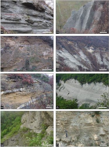
The stratigraphic succession () is characterized by the unconformable deposition of the middle Eocene – middle Miocene succession of the Epligurian Units onto the Monte Cassio Flysch (External Ligurian Units), Late Cretaceous – early Eocene (?) in age. The latter (‘Calcari di Zebedassi’ of CitationBoni, 1969a, Citation1969b) consists of very poorly exposed clayey marls, alternating with highly disrupted beds of carbonate-rich calcareous-marly turbidites, decimeters to meters thick ((A and B)).
Figure 2. Stratigraphic cross-section showing the relationships between the Tertiary Piedmont Basin (modified from CitationGhibaudo et al., 1985) and the Northern Apennines (External Ligurian Units and Epiligurian Units) successions across the Villalvernia – Varzi Line (see text for details).
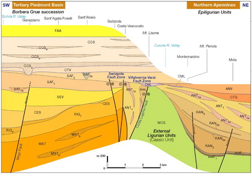
Figure 3. Stratigraphic succession of the External Ligurian Units (A–B) and Epiligurian Units (C–H): (A) Alternating calcareous turbidites, in decimeters to one meters thick beds, and gray clay of the Monte Cassio Flysch (Cassio Unit of the External Ligurian Units; close to Cosola) (B) Close-up of the calcareous turbidites of (A), showing typical ichnofossil traces. (C) Alternating whitish and reddish clayey-marl of the ‘Varicolored Mb’. of the Monte Piano marls (close to Ramella). (D) Detail of microconglomerates of the Val Pessola Mb. (Ranzano Formation), sourced from denudation of ophiolitic-derived Ligurian Units (Casasco). Hammer for scale. (E) Grayish pelite of the Varano de’ Melegari Mb., alternating with decimeters thick beds of arenite (Ranzano Formation; North of Montegioco). (F) Matrix-supported conglomerate, with clast derived from denudation of External Ligurian Units, characterizing the basal part of the Varano de’ Melagari Mb. (Ranzano Formation; West of Montegioco). (G) Panoramic view of the clayey marl of the Antognola Formation (ANT), hosting two main olistostromes (‘Polygenetic argillaceous breccias’; ANT1a) sourced from gravitational dismemberment of ‘basal complexes’ of the External Ligurian Units and Eocene – early Oligocene succession of the Epiligurian Units (see also (B)). Note that in the uppermost olistostrome (ANT1a), blocks occur only in the upper part (dated to uppermost late Oligocene), few meters below the unconformity that bounds at the base the Monte Vallassa sandstones (AMV), Serravallian in age (SW of Monte Penola). (H) Whitish calcareous marl of the Contignaco Formation (North of Lavasello).
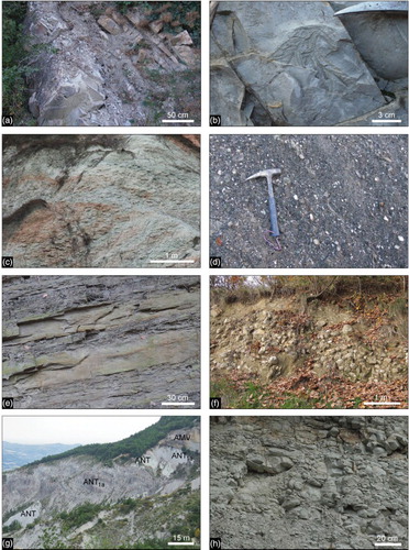
The hemipelagic Monte Piano marls (CitationMarchesi, 1961; CitationPieri, 1961) of middle-late Eocene in age represent the stratigraphic base of the Epiligurian Units ((C)). They are overlain with an unconformity surface, by the shallow water sediments of the Ranzano Formation (late Eocene – early Oligocene), which locally are deposited directly on the Monte Cassio Flysch. The Ranzano Formation consists of two members (Val Pessola Mb of late Prabonian – early Rupelian age, and Varano de’ Melegari Mb. of Rupelian age, see CitationMartelli, Cibin, Di Giulio, & Catanzariti, 1998), that differ on the lithic content. Lithics present in the Val Pessola Mb. derive from the denudation of ophiolite-rich Ligurian units and associated erosional sediments ((D)), whereas the lithic content of the Varano de’ Melegari Mb ((E and F)) is related to the Helmintoid Flysch of the External Ligurian Units (e.g. CitationDi Giulio, 1990; CitationMartelli et al., 1998; CitationMutti et al., 1995). The Ranzano Formation grades upward to slope fine-grained hemipelagic deposits of the Antognola Formation (early Oligocene – Aquitanian; see (G)). The latter Formation is interfingered by lenticular bodies of polygenetic argillaceous breccias (‘Complesso caotico pluriformazionale’ CitationGelati et al., 1974; see 4(A and B); see also CitationFesta, Ogata, Pini, Dilek, & Codegone, 2014), that show a block-in-matrix fabric (olistostromes sensu CitationPini, 1999 or ‘epi-nappe sedimentary mélanges’ sensu CitationFesta, Dilek, Pini, Codegone, & Ogata, 2012; CitationFesta, Pini, Dilek, & Codegone, 2010). The polygenetic breccias result from submarine mud/debris flow processes that involve cohesive and heterogeneous material ((A and B)) sourced from exhumed External Ligurian and Epiligurian Units (see also CitationCodegone, Festa, Dilek, & Pini, 2012; CitationFesta & Codegone, 2013). To the east of the studied area, older olistostromes are interfingered in early Oligocene marls (see CitationPanini, Fioroni, & Fregni, 2013). The siliceous marl of the Contignaco Formation (‘Tripoli di Contignaco’, CitationMarchesi, 1961; CitationPieri, 1961; ‘Marne di Monte Lumello’, CitationBoni, 1969b), Burdigalian in age, follows upward the Antognola Formation ((H)).
Figure 4. Stratigraphic succession of the Epiligurian Units: (A) Block-in-matrix fabric of the ‘Polygenetic argillaceous breccias’ (ANT1a) olistostromes, interbedded within the Antognola Formation (SW of Monte Penola). (B) Close-up of a block of the Val Pessola Mb. of the Ranzano Formantion (RAN2) embedded within the matrix of the ‘Polygenetic argillaceous breccias’ (SW of Monte Penola). Hammer for scale. (C, D) Block-in-matrix fabric of the Monte Lisone Chaotic Complex, with tabular to irregular shaped blocks of graysh marly-limestone and yellowish calcarenite randomly distributed within a brecciated marly matrix (Monte Lisone). Hammer for scale in (C). (E) Well-bedded yellowish sand and fossiliferous sandstone, in decimeters thick beds, of the Monte Vallassa sandstone (WSW of Monte Penola) and (F) Close-up of fossiliferous sandstone of the Monte Vallassa sandstone, showing rodolites of red algae and reworked fragments of lamellibranchies (W of Monte Penola).
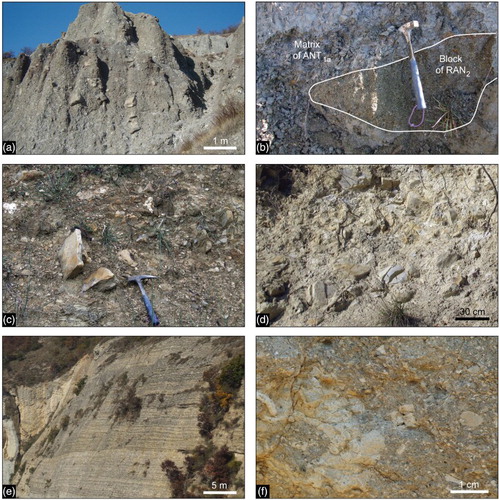
A third chaotic rock body of late Burdigalian – Langhian(?) age, with tabular to irregular shaped blocks mainly of Helmintoid Flysch embedded in a marly matrix (Mt. Lisone Chaotic Complex, (C and D)), rests unconformably on both the Monte Cassio Flysch and Antognola Formation. Locally, it reworks portions of the polygenetic argillaceous breccias. It is followed unconformably by the shallow and coarse shelf deposits of the Monte Vallassa sandstones (CitationGelati & Vercesi, 1994) of the Bismantova Group, Langhian(?) – Serravallian – Tortonian (?) in age ((E and F)). The Monte Lisone Chaotic Complex, here described for the first time, seals the E-striking fault that bounds to the north the Villalvernia – Varzi Line (see Main Map).
4.1.2. Tertiary Piedmont Basin
The stratigraphic succession () of this sector of the Tertiary Piedmont Basin (i.e. Borbera – Grue zone sensu CitationGelati & Gnaccolini, 1988) is characterized by a regressive – transgressive trend (CitationGelati & Gnaccolini, 1988; CitationGhibaudo et al., 1985; CitationMarroni et al., 2010), starting with the Monastero Formation (sensu CitationBellinzona, Boni, Braga, & Marchetti, 1971; CitationGhibaudo et al., 1985) of Rupelian age ((A)). It represents a slope base turbiditic deposition with local occurrence of residual deposits emplaced by voluminous fluxes (CitationMarroni et al., in press), and followed by the Rigoroso Formation (sensu CitationAndreoni, Galbiati, Maccabruni, & Vercesi, 1981; CitationGhibaudo et al., 1985) of Rupelian – Aquitanian age. The latter formation consists of two members, separated by a sharp erosional surface, and corresponds to a submarine fan (upper member; (C)) deposited on a slope-to-basin (lower member; (B)) succession (CitationAndreoni et al., 1981; CitationGalbiati, 1976; CitationGhibaudo et al., 1985). The Rigoroso Formation is followed by the outer shelf deposits of the Cessole Formation (Cessole marls of CitationBellinzona et al., 1971) of Langhian age ((D)), which are bounded at the base by an unconformity surface outlined by a discontinuous horizon of sandstone and conglomerate (CitationAndreoni et al., 1981; CitationDi Napoli Alliata, 1953; CitationGelati, 1977; CitationGhibaudo et al., 1985; CitationLabesse, 1966; CitationVervloet, 1966). The inner shelf deposits of the Serravalle Formation (Serravallian) follow upward ((E)) and pass unconformably to outer shelf sandstone and siltstone (lower member) and slope marls (upper member) of the Sant'Agata Fossili marls ((F)), Tortonian-to-early Messinan in age. The upper member of the Sant'Agata Fossili marls is truncated by a lenticular body of channelized conglomerates (Sant'Alosio conglomerates) of early Messinian age (see also CitationGhibaudo et al., 1985). The uppermost part of the Tertiary Piedmont Basin succession is characterized by the unconformable deposition of the chaotic succession of the Valle Versa Chaotic Complex (sensu CitationDela Pierre, Piana, Fioraso, & Boano, 2003; see (G)) of post-evaporitic late Messinian age, which is followed by fan-delta deposits of the Cassano Spinola conglomerates ((H)), late Messinian in age (see also CitationGhibaudo et al., 1985), and by the lower Pliocene Argille Azzurre.
Figure 5. Stratigraphic succession of the Tertiary Piedmont Basin: (A) Fine-to-medium-grained sandstone, in decimeters to one meter thick beds, of the Monastero Formation (SE of Frascata). (B) Grayish marl and silty marl in decimeters thick beds of the Rigoroso Formation (Ramero inferiore). (C) Brownish massive sandstone, characterizing the upper member (RIG1) of the Rigoroso Formation (WSW of Poggio Maggiore). (D) Well bedded whitish siltstone and sandstone of the Cessole Formation, interbedded upward by yellowish sandstone (NE of Monte Provinera). (E) Alternating yellowish sandstone and grayish cemented sandstone in decimeters thick beds of the Serravalle Formation (WNW of San Vito). (F) Alternating whitish sandstone and siltstone in decimeters thick beds of the lower member of the Sant'Agata Fossili marls, dissected by a slump scar (black arrow; see CitationClari & Ghibaudo, 1979 for major details) (East of Sant'Alosio). (G) Stratigraphic contact between the Valle Versa Chaotic Complex of late Messinian age, here represented by a reworked huge block of selenitic gypsum (CTVgs), and the upper pelitic member of the Sant'Agata Fossili marls (SAF2), Tortonian – early Messinian in age (Ripa dello Zolfo, North of Castellania). (H) Pelite and siltstone, alternating with decimetes thick beds of sandstone and microconglomerate of the Cassano Spinola conglomerates (SE of Cassano Spinola).
4.1.3. Continental deposits
The Quaternary succession is represented by terraced fluvial deposits distributed along the Scrivia, Grue and Curone valleys, right tributaries of the Po River. Based on morphostratigraphic criteria (CitationGelati et al., 2010), seven units, grouped in three synthems, have been distinguished: from the oldest to youngest the Piandendice Synthem (upper part of Lower Pleistocene – Middle Pleistocene?), the Merana Synthem (upper Pleistocene) and the Cairo Montenotte Synthem (uppermost part of the Upper Pleistocene – Present). Deposits are made up mostly of clast-supported gravels and sandy gravels, crudely bedded, mantled by a decimeter to meter thick (3–4 m) overbank deposits made up of sands and silts with planar to wavy lamination or massive. In the absence of precise chronological data available for the continental succession included in the mapped area, the ages of the terraced succession have been derived from adjacent area of the Tertiary Piedmont Basin (the Bormida Valley) where a comparable and correlable fluvial succession has been previously mapped (CitationBellino et al., in press; CitationGelati et al., 2010).
Deposits referred to the Piandendice Synthem form broad terraces separated from the adjacent units by an impressive scarp up to 75 m high, which corresponds to the western edge of the Borbera Grue domain. Instead younger units are separated from each other by erosional scarps a few meters high (2–15 m). Along the Scrivia Valley, between Serravalle (to the South) and Tortona (to the North) a gradual downstream convergence of terraces can be observed, similarly to the fluvial terraces of the Bormida Valley, 15 km West of the Scrivia River. Such configuration can be interpreted as a result of differential exumation (active from Gelasian onward) involving the Tertiary Piedmont Basin, accompanied by the progressive northward shifting of the margin of the Alessandria Basin (CitationBellino et al., in press) progressively downcutted by the drainage system.
4.2. Tectonic setting
The tectonic setting of the External Ligurian and Epiligurian Units of Northern Apennines (section 4.2.1), and of the Tertiary Piedmont Basin (section 4.2.3), separated by the fault zone associated with the Villalvernia – Varzi Line (Villavernia – Varzi Fault zone hereafter, see Section 4.2.2), are described in the following sections (see Main Map).
4.2.1. The Northern Apennines
Different tectonic settings characterize the External Ligurian Units and Epiligurian Units (see Geological Map). The Late Cretaceous Monte Cassio Flysch (External Ligurian Units) depicts a roughly E-to ESE-dipping monocline, with local open folds with NE-to ENE-striking fold axis. Close to the Villalvernia – Varzi Line, bedding is gradually rotated to E-W direction and aligned with the northernmost fault bounding this fault zone. The overlaying Epiligurian succession shows a regular monocline, NE-dipping, mainly consisting of the Ranzano Formation that is locally bounded at the base by the Monte Piano marls (see Cross-section 1). This monocline corresponds to the southwestern limb of a regional scale syncline with the northeastern limb exposed North of the mapped sector. Two main fault sets (NE-SW and E-W-to WNW-ESE directed) dissect the Epiligurian succession. The NE-striking normal faults seems to have controlled the deposition of the Ranzano Formation as suggested by the decrease in thickness both toward WNW and ESE of both the Val Pessola Mb. and Varano de’ Melagri Mb. The former shows a lenticular shape with the maximum thickness observed in the sector between Scrimignano and Curone Valley (see Main Map). The W-to-WNW-striking faults define hundreds of meters fault zones, consisting of different anastomosed transpressive fault segments. They control the rotation of the bedding which, close to these faults, is sub-vertical -to overturned (e.g. North of Casasco in the Main Map) and is aligned to the same faults. At the mesoscale, the W-to WNW-striking faults crosscut the NE-striking faults and locally reactivates the NE-verging contractional faults.
4.2.2. The Villavernia – Varzi Fault Zone
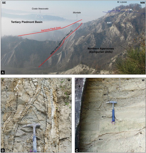
It corresponds to an E-striking fault zone, up to one kilometer wide, which depicts an asymmetric flower structure in cross-section (see Main Map and Cross-sections 1 and 2). It is bounded by two main faults (the Costa Lugrina Fault, to the North, and the Avolasca-Musigliano Fault, to the South), tens of kilometers long, that show the same orientation of the main fault zone and are connected each other by a complex system of WNW-and ENE-striking subvertical minor faults. The latters show anastomosed geometry with isolated sub-vertical tectonic slices, hundreds of meters to kilometers long that mainly involve the Ranzano and Antognola Formations. The E-striking Costa Lugrina Fault, which juxtaposes the Villalvernia –Varzi Fault Zone to the External Ligurian Units, is unconformably sealed by the Mt. Lisone Chaotic Complex of Late Burdigalian – Langhian(?) age. Differently, the E-striking Avolasca – Musigliano Fault, which juxtaposes the Villalvernia – Varzi Fault Zone with the Tertiary Piedmont Basin succession (i.e. Monastero and Rigoroso Formations), dissects with mainly extensional components small outcrops of the Mt. Lisone Chaotic Complex (i.e. SW of Brignano). Mesostructural data show left-lateral movement along the Villalvernia – Varzi Fault Zone affecting the Rupelian – early Miocene succession below the unconformity at the base of the Mt. Lisone Chaotic Complex) that is, in turn, crosscut to the West by a NW-striking fault zone (Sarizzola Fault Zone; see below Section 4.2.3.; see also (A)).
Figure 6. (A) Panoramic view of the tectonic juxtaposition of the Northern Apennines (Epiligurian Units) and Tertiary Piedmont Basin close to Costa Vescovato. Here, the western prolongation of the Villalvernia – Varzi Fault Zone, E-striking, is crosscut by the NW-striking Sarizzola Fault Zone. The Monte Lisone Chaotic Complex (late Burdigalian – Langhian?; CML) rests unconformably onto the Antognola Formation (ANT), Rupelian – Aquitanian in age. (B) N-striking transtensional faults, locally showing a ‘tulip’ flower structure, dissect the upper member of the Sant'Agata Fossili marl (South of Giusulana). Hammer for scale. (C) N-striking extensional fault dissecting the Cassano Spinola conglomerates (Albergo locality, SW of Cassano Spinola). Hammer for scale.
4.2.3. The Tertiary Piedmont Basin
South of the Villalvernia – Varzi Fault Zone, the Tertiary Piedmont Basin is characterized by a regular NW-dipping Oligocene – Pliocene monocline that is bounded to NW by the NW-striking Sarizzola Fault zone (see Main Map and (A)). The latter crosscuts the western prolongation of the Villalvernia – Varzi Fault Zone and corresponds to a pluri-kilometers long fault zone (up to hundreds of meters wide) developed between Avolasca and Costa Vescovato – Montale. It consists of different anastomosed faults, isolating sub-vertical lenses of both Tertiary Piedmont Basin succession and External Ligurian and Epiligurian Units. Mesostructural analyses show left-lateral movements that decrease in the degree of the displacement toward NW where the fault zone shows a horse-tail termination. In this sector, the upper member of the Sant'Agata Fossili marls (Tortonian – early Messinian) lies unconformably on both the Tertiary Piedmont Basin succession and External Ligurian Units. It is worth noting that the NW-striking Sarizzola Fault Zone is parallel to the Vargo Fault of CitationGhibaudo et al. (1985), located to the South of the mapped sector, that acted in the same time interval (i.e. Tortonian). The channelized body of the Sant'Alosio conglomerate (upper member of Sant'Agata Fossili marls) is NW-aligned, suggesting a tectonically driven sedimentary deposition.
The NW-dipping monocline of the Tertiary Piedmont Basin succession shows a gradual decrease in dip (from 30° to 10°) toward WNW and from older to younger sediments (see Main Map). The different lithostratigraphic units decrease in thickness toward NE, showing their minimum close to the Villalvernia – Varzi Fault Zone (see Cross-sections n. 1 and ) with local pinch-out terminations (i.e. the arenitic member of the Monastero Formation). The Langhian – Serravallian succession gradually closes toward the Sarizzola Fault Zone with bedding rotation up to the alignment to the same fault zone. Bedding rotation and alignment to the NW-striking fault zone is also recorded within the Sant'Agata Fossili marls (Tortonian – early Messinian) and gradually decreased with the deposition of the Valle Versa Chaotic Complex of late Messinian age (see Main Map).
Minor N-striking normal faults ((A and B)), hundreds of meters long, dissect different terms of the Tertiary Piedmont Basin succession up to the Cassano Spinola conglomerates (late Messinian). Non-mappable, N-striking faults also dissect the lower Pliocene Argille Azzurre.
5. Conclusions
Our geological map describes in detail the sector of tectonic juxtaposition between the Northern Apennines and Tertiary Piedmont Basin that occurs along the Villalvernia – Varzi Fault Zone. The crosscutting relationships between mapped faults and stratigraphic unconformities allow the definition of four main tectonic stages that occurred sequentially from the late Eocene to the early Pliocene ():
Late Priabonian – Rupelian: although minor WNW-to E-striking transtensional faults were developed along the proto-Villalvernia – Varzi Fault Zone, the NE-striking extensional faults dominated during this tectonic stage. The latter controlled the drowning of the late Eocene – early Oligocene shelf – to slope sediments of the Ranzano Formation as indicated by both the WNW-ESE and N-S change in thickness. The Monastero Formation and the Varano de’ Melegari Mb. of the Ranzano formation differentiated from each other, according to their different depositional settings. This is in agreement with the ‘infra-Rupelian motion of the Villalvernia – Varzi line’ which generated submarine relief dividing, for the first time, the Eastern Tertiary Piedmont Basin from the coeval sediments of the Epiliguirian Units (CitationCavanna et al., 1989; CitationDi Giulio & Galbiati, 1995; CitationFelletti, 2002). At regional scale, this stage is related to the opening of the Balearic Sea that affected the Ligurian realm (Ligurian phase II of CitationMutti et al., 1995; Faulting stage A of CitationFesta et al., 2005, Citation2013; CitationPiana, 2000 in Torino Hill and Monferrato).
Chattian – early Miocene: the late Priabonian – Rupelian extensional regime was inverted to a compressional regime that accompanied the deposition of the Rigoroso and Antognola Formations. The E-striking Villalvernia – Varzi Fault Zone developed by the interlacing of WNW-striking left-lateral tranpressive faults and it acquired an asymmetric flower structure geometry in cross-section. The submarine high formed during Rupelian time (see CitationCavanna et al., 1989; CitationDi Giulio & Galbiati, 1995) was reactivated in the sector of the Tertiary Piedmont Basin by left-lateral transpressive movements along the Villalvernia – Varzi line as suggested, to the East of the studied sector, by the onlap deposition of Aquitanian turbidides (i.e. Castagnola Formation in CitationCavanna et al., 1989) onto the folded Oligocene succession (see also CitationFelletti, 2002, Citation2004; CitationIbbeken, 1978). The resultant axis of the Aquitanian basin was oriented parallel to the Villalvernia – Varzi line (CitationCavanna et al., 1989; CitationFelletti, 2002). Gravitational instability on the Apenninic side of the fault zone is recorded by the emplacement of different olistostromes sourced by the denudation of the External Ligurian and Epiligurian Units (see also CitationFesta et al., 2014). At regional scale, this stage is related to the northern migration of the Apenninic thrust front (Ligurian Phase III of CitationMutti et al., 1995, see also CitationGhibaudo et al., 1985; Faulting stage B of CitationFesta et al., 2005, Citation2013; CitationPiana, 2000 in Torino Hill and Monferrato), and to the anticlockwise rotation of the Tertiary Piedmont Basin s.s. that was accommodated by the strike-slip movements along the Villalvernia – Varzi Fault Zone. This tectonic stage was sealed by the unconformable deposition of the Mt. Lisone Chaotic Complex (late Burdigalian – Langhian?), which sealed the northernmost bounding fault of the Villalvernia – Varzi Fault zone, and of the Monte Vallassa sandstones (Langhian? – Serravallian – Tortonian?).
late Serravallian –Tortonian: during this tectonic stage, the NW-striking Sarizzola Fault Zone crosscut with transtensional left-lateral movements the Villalvernia –Varzi Fault Zone. The deposition of the outer shelf-to slope deposits of the Sant'Agata Fossili marls marked a regional drowning of the basins whose internal physiography was apparently controlled by the NW-striking faults as suggested by the same orientation of the channelized deposits of the Sant'Alosio conglomerates (see also the Tortonian activity of the Vargo Fault described by CitationGhibaudo et al., 1985 to the South of the mapped sector). At regional scale, this deformational stage is well consistent with the transpressional stress regime controlling the overall subsidence of the Tertiary Piedmont Basin as associated with the convergence of the Apennines and Southern Alps thrust systems (e.g. CitationMaino et al., 2013; CitationMosca et al., 2010). The anticlockwise rotation of the Tertiary Piedmont Basin continued during this stage, as shown by the rotation of the bedding surfaces of the early-to-late Miocene succession and by their alignment to the NW-striking Sarizzola Fault Zone. This tectonic stage was sealed by the uncoformable deposition of the late Messinian Valle Versa Chaotic Complex.
late Messinian – early Pliocene: a N-dipping regional tilting, probably controlled by a regional N-S shortening, possibly related to the Northward movement of the Apenninic frontal thrust (see, e.g. CitationMosca et al., 2010; CitationFesta, 2011), occurred during this tectonic stage. The tilting caused the gravitational emplacement of sub-marine mass-transport deposits, forming the Valle Versa Chaotic Complex (CitationDela Pierre, Festa, & Irace, 2007; CitationDela Pierre, Martire, Natalicchio, Clari, & Petrea, 2010; CitationFesta, 2011). Extensional tectonics, mainly controlled by N-striking faults, continued up to early Pliocene time, as suggested by the occurrence of mesoscale faults in the Argille Azzurre.
Figure 7. Structural sketch of the studied sector, showing the crosscutting relationships between different faulting stages (indicated with different colors). These relationships allow defining four tectonic stages as summarized in the time column in the right part of the figure (see text for a complete explanation).
Software
The geological map was digitized using Esri ArcView 3.1 and then edited with Adobe Illustrator 10. This latter has also been used for the drawing of the geological sections and for the arrangement of the illustrations in this paper.
TJOM_959569_supplemental_material.pdf.pdf
Download PDF (8.7 MB)Acknowledgements
We thank G. Codegone, G. Ghibaudo and L. Papani for passionate discussions on the geology of the studied sector and we would like to express our sincere thanks to the Guest Editor M. Zucali, and the three Referees (J.L. Alonso, F. Felletti, and J.E. Carrell) for their constructive and thorough reviews and useful comments, from which we have benefited greatly in revising both our manuscript and geological map. We are indebted and very grateful to M. Dadone who kindly and accurately processed the samples for paleontological analyses. Special thanks to F. Forlati and M. Morelli (ARPA Piemonte) for supporting the research project. Research has been supported by ‘ARPA Piemonte’, ‘ex 60%–2012’ (Università degli Studi di Torino, grants to A. Festa), the Italian Ministry of University and Research (Cofin-PRIN 2010/2011, grants n. 2010AZR98L_002 – G.A. Pini, to A. Festa), and ‘ex 60%–2012’ (Università degli Studi di Torino, grants to A. Festa).
Related Research Data
References
- Andreoni, G., Galbiati, B., Maccabruni, A., & Vercesi, P. L. (1981). Stratigrafia e paleogeografia dei depositi oligocenici superiori – miocenici inferiori nell'estremità orientale del Bacino Ligure piemontese. Rivista Italiana di Paleontologia e Stratigrafia, 87, 245–281.
- Bellino, L., Irace, A., D'Atri, A., Varrone, D., Piana, F., Cadoppi, P., … Fioraso, G. (in press). Carta Geologica d'Italia alla scala 1:50.000, Foglio 194 Acqui Terme. ISPRA – Istituto Superiore per la Protezione e la Ricerca Ambientale.
- Bellinzona, G., Boni, A., Braga, G., & Marchetti, G. (1971). Note illustrative della Carta Geologica d'Italia in scala 1:100.000 Foglio 71 Voghera. Servizio Geologico d'Italia, Roma, 1–121.
- Biella, G., Gelati, R., Lozej, A., Rosisi, P. M., & Tabacco, I. (1988). Sezioni geologiche nella zona limite Alpi occidentali–Appennino settentrionale ottenute da dati geofisici. Rendiconti della Società Geologica Italiana, 11, 287–292.
- Biella, G., Polino, R., de Franco, R., Rossi, P. M., Clari, P., Corsi, A., & Gelati, R. (1997). The crustal structure of the Western Po Plain: Reconstruction from integrated geological and seismic data. Terra Nova, 9, 28–31. doi: 10.1046/j.1365-3121.1997.d01-5.x
- Bigi, G., Cosentino, D., Parotto, M., Sartori, R., & Scandone, P. (1983). Structural Model of Italy: Geodynamic project, C.N.R., S.El.Ca. Firenze, scale 1:500,000, 9 sheets.
- Boccaletti, M. (1982). Carta Strutturale dell'Appennino settentrionale. C.N.R., Progetto Finalizzato geodinamica, Sottoprogetto 5 – Modello Strutturale, pubblicazione n.429. S.El.Ca. Firenze, scale 1:250,000, 3 sheets.
- Boni, A. (1961). Per la Geologia dell'Appennino settentrionale a W della Linea La Spezia – Piacenza. Atti dell'Istituto Geologico dell'Università di Pavia, 12, 63–196.
- Boni, A. (1969a). Carta Geologica d'Italia a scala 1:100.000. Foglio 70 Alessandria. Servizio Geologico d'Italia, Stab. L. Salomone, Roma.
- Boni, A. (1969b). Carta Geologica d'Italia a scala 1:100.000. Foglio 71 Voghera. Servizio Geologico d'Italia, Stab. L. Salomone, Roma.
- Castellarin, A. (1994). Strutturazione eo-mesoalpina dell'Appennino Settentrionale attorno al ‘nodo ligure’. In R. Capozzi & A. Castellarin (Eds.), Studi preliminari all'acquisizione dati del profilo CROP 1-1A La Spezia – Alpi orientali (pp. 99–108). Studi Geologici Camerti, Volume Speciale 1992/2, Appendice.
- Cattaneo, M., Eva, C., & Merlanti, F. (1986). Alcune considerazioni sulla sismicità dell'Appennino Nord-Occidentale. Memorie descrittive della Carta Geologica d’ Italia, 35, 36–68.
- Cavanna, F., Di Giulio, A., Galbiati, B., Mosna, S., Perotti, C. R., & Pieri, M. (1989). Carta geologica dell'estremità orientale del Bacino Terziario Ligure-Piemontese. Atti Ticinensi di Scienze della Terra, 32, 1 sheet.
- Cavazza, W., Roure, F., & Ziegler, P. A. (2004). The mediterranean area and the surrounding regions: Active processes, remnants of former Tethyan oceans and related thrust belts. In W. Cavazza, F. Roure, W. Spakman, G. M. Stampfl, & P. A. Ziegler (Eds.), The TRANSMED atlas: The mediterranean region from crust to mantle (pp. 1–29). Berlin: Springer.
- Cerrina Feroni, A., Ottria, G., Martinelli, P., & Martelli, L. (2002). Carta geologico-strutturale dell'Appennino emiliano – romagnolo alla scala 1:250.000. Regione Emilia Romagna, C.N.R., Ed. S.EL.CA. Firenze.
- Clari, P., & Ghibaudo, G. (1979). Multiple slump scars in the Tortonian type area (Piedmont Basin, northwestern Italy). Sedimentology, 26(5), 719–730. doi: 10.1111/j.1365-3091.1979.tb00939.x
- Codegone, G., Festa, A., Dilek, Y., & Pini, G. A. (2012). Small-scale Polygenetic mélanges in the Ligurian accretionary complex, Northern Apennines, Italy, and the role of shale diapirism in superposed mélange evolution in orogenic belts. In Y. Dilek, A. Festa, Y. Ogawa, & G. A. Pini (Eds.), Chaos and Geodynamics: Mélanges, Mélange-forming Processes and Their Significance in the Geological Record. Tectonophysics, 568–569 (pp. 170–184).
- Coward, M. P., & Dietrich, D. (1989). Alpine tectonics – An overview. In M. P. Coward, D. Dietrich, & R. G. Park (Eds.), Alpine tectonics (Vol. 45, pp. 1–29). Geological Society of London Special Publication.
- Dela Pierre, F., Festa, A., & Irace, A. (2007). Interaction of tectonic, sedimentary and diapiric processes in the origin of chaotic sediments: An example from the Messinian of the Torino Hill (Tertiary Piedmont Basin, NW Italy). Geological Society of America Bulletin, 119(9/10), 1107–1119. doi: 10.1130/B26072.1
- Dela Pierre, F., Martire, L., Natalicchio, M., Clari, P., & Petrea, C. (2010). Authigenic carbonates in Upper Miocene sediments of the Tertiary Piedmont Basin (NW Italy): Vestiges of an ancient gas hydrate stability zone? Geological Society of America Bulletin, 122, 994–1010. doi: 10.1130/B30026.1
- Dela Pierre, F., Piana, F., Fioraso, G., & Boano, P. (2003). Note Illustrative della Carta Geologica d'Italia alla scala 1:50.000. Foglio 157 ‘Trino’. Servizio Geologico d'Italia – ARPA Piemonte, 1–147.
- Di Giulio, A. (1990). Litostratigrafia e petrografia della successione eo-oligocenica del Bacino Terziario Ligure-Piemontese, nell'area compresa tra le valli Grue e Curone (provincia di Alessandria, Italia settentrionale). Bollettino della Società Geologica Italiana, 109, 279–298.
- Di Giulio, A., & Galbiati, B. (1995). Interaction between tectonics and deposition into an episutural basin in the Alps-Apennines knot. In R. Polino & R. Sacchi (Eds.), Atti del Convegno sul tema ‘Rapporti tra Alpi e Appennino’ e guida alle escursioni (pp. 113–128). Roma: Accademia Nazionale delle Scienze detta dei XL, Scritti e Documenti.
- Di Napoli Alliata, E. (1953). Microfaune della parte superiore della serie oligocenica del Monte San Vito e del Rio Mazzapiedi – Castellania (Tortona – Alessandria). Rivista Italiana di Paleontologia e Stratigrafia, Memorie, 6, 25–98.
- Elter, P., Grasso, M., Parotto, M., & Vezzani, L. (2003). Structural setting of the Apennine – Maghrebian thrust belt. Episodes. International Journal of Geosciences, 26(3), 205–211.
- Elter, P., & Pertusati, P. C. (1973). Considerazioni sul limite Alpi-Appennino e sulle relazioni con l'arco delle Alpi occidentali. Memorie della Società Geologica Italiana, 12, 359–375.
- Felletti, F. (2002). Complex bedding gemometries and facies associations of the turbiditic fill of a confined basin in a transpressive setting (Castagnola Fm., Tertiary Piedmont Basin, NW Italy). Sedimentology, 49, 645–667. doi: 10.1046/j.1365-3091.2002.00467.x
- Felletti, F. (2004). Statistical modelling and validation of correlation in turbidites: An example from the Tertiary Piedmont Basin (Castangola Fm., Northern Italy). Marine and Petroleum Geology, 21, 23–39. doi: 10.1016/j.marpetgeo.2003.11.006
- Festa, A. (2011). Tectonic, sedimentary, and diapiric formation of the Messinian melange: Tertiary Piedmont Basin (northwestern Italy). In J. Wakabayashi & Y. Dilek (Eds.), Melanges: Processes of formation and societal significance (Vol. 480, pp. 215–232). Geological Society of America Special Paper. doi: 10.1130/2011.2480(10)
- Festa, A., & Codegone, G. (2013). Geological map of the external ligurian units in western Monferrato (Tertiary Piedmont Basin, NW Italy). Journal of Maps, 9(1), 84–97. doi:10.1080/17445647.2012.757711, including a geological map at 1:10,000 scale.
- Festa, A., Dela Pierre, F., Irace, A., Piana, F., Fioraso, G., Lucchesi, S., … Forno, M. G. (2009). Note Illustrative della Carta Geologica d'Italia alla scala 1:50,000. Foglio 156 ‘Torino Est’. ISPRA, Istituto Superiore per la Protezione e la Ricerca Ambientale, Litografia Geda, Nichelino, 1–143.
- Festa, A., Dilek, Y., Codegone, G., Cavagna, S., & Pini, G. A. (2013). Structural anatomy of the Ligurian accretionary wedge (Monferrato, NW-Italy), and evolution of superposed Mélanges. Geological Society of America Bulletin, 125(9/10), 1580–1598. doi: 10.1130/B30847.1
- Festa, A., Dilek, Y., Pini, G. A., Codegone, G., & Ogata, K. (2012). Mechanisms and processes of stratal disruption and mixing in the development of mélanges and broken formations: Redefining and classifying mélanges. In Y. Dilek, A. Festa, Y. Ogawa, & G. A. Pini (Eds.), Chaos and Geodynamics: Mélanges, Mélange-forming Processes and Their Significance in the Geological Record. Tectonophysics, 568–569 (pp. 7–24).
- Festa, A., Ogata, K., Pini, G. A., Dilek, Y., & Codegone, G. (2014). Late Oligocene – early Miocene olistostromes (sedimentary mélanges) as tectono-stratigraphic constraints to the geodynamic evolution of the exhumed Ligurian accretionary complex (Northern Apennines, NW Italy). International Geology Review, in press. doi: 10.1080/00206814.2014.931260
- Festa, A., Piana, F., Dela Pierre, F., Malusà, M. G., Mosca, P., & Polino, R. (2005). Oligocene-Neogene kinematic constraints in the retroforeland basin of the Northwestern Alps. Rendiconti della Società Geologica Italiana (nuova serie), 1, 107–108.
- Festa, A., Pini, G. A., Dilek, Y., & Codegone, G. (2010). Mélanges and mélange-forming processes: A historical overview and new concepts. In Y. Dilek (Ed.), Alpine Concept in Geology. International Geology Review, 52(10–12), 1040–1105. doi:10.1080/00206810903557704
- Galbiati, B. (1976). La successione oligo-miocenica tra Rigoroso e Carrosio (Bacino ligure – piemontese). Atti dell'Istituto Geologico dell'Università di Pavia, 26, 30–48.
- Gelati, R. (1977). La successione eo-oligocenica di Garbagna (Alessandria) al margine orientale del Bacino Terziario Ligure Piemontese. Rivista Italiana di Paleontologia, 83, 103–136.
- Gelati, R., Bruzzi, D., Catasta, G., & Cattaneo, P. C. (1974). Evoluzione stratigrafico – strutturale nell'Appennino vogherese a nord-est della Val Staffora. Rivista Italiana di Paleontologia e Stratigrafia, 80(3), 479–514.
- Gelati, R., & Gnaccolini, M. (1988). Sequenze de posizionali in un bacino episuturale, nella zona di raccordo tra Alpi ed Appennino settentrionale. Atti Ticinensi di Scienze della Terra, 31, 340–350.
- Gelati, R., Gnaccolini, M., Polino, R., Mosca, P., Piana, F., Morelli, M., & Fioraso, G. (2010). Note illustrative della Carta Geologica d'Italia alla scala 1:50.000. Foglio 211 ‘Dego’. ISPRA – Istituto Superiore per la Protezione e la Ricerca Ambientale, Roma, 124 pp.
- Gelati, R., & Vercesi, P. L. (1994). Itinerario N° 3. Da Voghera a Tortona (Km 120). Geologia delle Valli Staffora, Curone, Grue: le Successioni Epiliguri a nord della Linea Villalvernia – Varzi. Guide Geologiche Regionali S.G.I., N° 6, BE-MA Editrice, 157–174.
- Germani, D., Angiolini, L., & Cita, M. B. (2003). Guida Italiana alla Classificazione e alla Terminologia Stratigrafica. APAT – Dipartimento Difesa del Suolo. Quaderni Serie III, 9, 155 pp.
- Ghibaudo, G., Clari, P., & Perello, M. (1985). Litostratigrafia, sedimentologia ed evoluzione tettonico sedimentaria dei depositi miocenici del margine sud-orientale del Bacino terziario Ligure – Piemontese. Bollettino della Società Geologica Italiana, 104, 349–397.
- Ibbeken, H. (1978). The Nivione structure: Contemporaneous tectonics and sedimentation between the Ligurian and Tuscan Orogenies. Int. Comm. Geodyn. Sci. Report, 38, 274–275.
- INGV. (2007). Catalogo dei terremoti recenti in Italia. www.ingv.it
- Labesse, B. (1966). Etude des terrains éocènes et oligocènes du basin liguro – piémontais dans la region de San Sebastiano Curone – Varzi (Apennin septentrional). Bulletin de la Société Géologique de France, Paris, serie VII, 8(7), 954–966.
- Laubscher, H. (1991). The arc of western Alps today. Eclogae Geologicae Helvetiae, 84, 631–659.
- Laubscher, H., Biella, G. C., Cassinis, R., Gelati, R., Lozej, A., Scarascia, S., & Tabacco, I. (1992). The collisional knot in Liguria. Geologische Rundschau, 81(2), 275–289. doi: 10.1007/BF01828598
- Maino, M., Decarlis, A., Felletti, F., & Seno, S. (2013). Tectono-sedimentary evolution of the Tertiary Piedmont Basin (NW Italy) within the Oligo-Miocene central Mediterranean geodynamics. Tectonics, 32, 593–619. doi: 10.1002/tect.20047
- Mantelli, L., & Vercesi, P. L. (2000). Evoluzione morfostrutturale recente del pedeappennino vogherese – tortonese. Atti Ticinensi di Scienze della Terra, 41, 49–58.
- Marchesi, R. (1961). Serie Stratigrafica di Monte Piano. Bollettino della Società Geologica Italiana, 80(1), 70–77.
- Marroni, M., Meneghini, F., & Pandolfi, L. (2010). Anatomy of the Ligure-Piemontese subduction system: Evidence from Late Cretaceous–middle Eocene convergent margin deposits in the Northern Apennines, Italy. International Geology Review, 52, 1160–1192. doi: 10.1080/00206810903545493
- Marroni, M., Ottria, G., Pandolfi, L., Catanzariti, R., Bernardeschi, A., Papani, L., … Taini, A. (in press). Carta Geologica d'Italia alla scala 1:50,000. Foglio 196 ‘Cabella Ligure’. ISPRA, Istituto Superiore per la Protezione e la Ricerca Ambientale,1 sheet at 1:50,000 scale.
- Martelli, L., Cibin, U., Di Giulio, A., & Catanzariti, R. (1998). Litostratigrafia della Formazione di Ranzano (Priaboniano-Rupeliano, Appennino Settentrionale e Bacino Terziario Piemontese). Bollettino della Società Geologica Italiana, 117, 151–185.
- Mosca, P., Polino, R., Rogledi, S., & Rossi, M. (2010). New data for the kinematic interpretation of the Alps–Apennines junction (Northwestern Italy). International Journal of Earth Sciences, 99(4), 833–849. doi: 10.1007/s00531-009-0428-2
- Mutti, E., Papani, L., Di Biase, D., Davoli, D., Mora, S., Segadelli, S., & Tinterri, R. (1995). Il Bacino Terziario Epimesoalpino e le sue implicazioni sui rapporti tra Alpi ed Appennino. Memorie di Scienze Geologiche di Padova, 47, 217–244.
- Ori, G. G., & Friend, P. F. (1984). Sedimentary basins formed and carried piggy-back on active thrust sheets. Geology, 12, 475–478.
- Panini, F., Fioroni, C., & Fregni, P. (2006). Geologia dell'area di Varzi (Appennino vogherese): Note preliminari. Atti Ticinensi di Scienze della Terra, 45(2004), 43–59.
- Panini, F., Fioroni, C., & Fregni, P. (2013). Le Brecce argillose di Musigliano (Appennino Vogherese – Tortonese): Dati stratigrafici preliminari. Rendiconti online della Società Geologica Italiana, 26, 21–31.
- Pasquarè, G., Abbate, E., Bosi, C., Castiglioni, G. B., Merenda, L., Mutti, E., … Sassi, F. P. (1992a). Carta Geologica d'Italia – 1:50.000. Guida al Rilevamento. Servizio Geologico Nazionale. Quaderni serie III. Vol. 1, 203 pp.
- Pasquarè, G., Abbate, E., Castiglioni, G. B., Merenda, L., Mutti, E., Ortolani, F., … Sassi, F. P. (1992b). Guida al rilevamento e all'informatizzazione della Carta Geologica d'Italia alla scala 1:50,000. Quaderni del Servizio Geologico Nazionale, serie III, 1, 203.
- Piana, F. (2000). Structural setting of Western Monferrato (Alps-Apennines junction zone, NW Italy). Tectonics, 19, 943–960. doi: 10.1029/2000TC900013
- Pieri, M. (1961). Nota introduttiva al rilevamento del versante appenninico padano eseguito nel 1955–1959 dai geologi dell'Agip Mineraria, con carta geologica alla scala 1:100.000. Bollettino della Società Geologica Italiana, Roma, 80(1), 3–34.
- Pini, G. A. (1999). Tectonosomes and olistostromes in the Argille Scagliose of the northern Apennines, Italy. Geological Society of America Special Paper, 335, 1–73.
- Ricci Lucchi, F. (1986). The Oligocene to recent foreland basin of the northern Appennines. In P. A. Allen & P. Homewood (Eds.), Foreland basins (pp. 105–139). Freiburg: International Association of Sedimentologists Special Publication 8, Blackwell.
- Ricci Lucchi, F., & Ori, G. G. (1985). Field excursion D: Syn-orogenic deposits of a migrating basin system in the NW Adriatic foreland. In P. Allen (Ed.), Foreland basins, excursion guidebook (pp. 137–176). Freiburg: International Association of Sedimentologists Special Publication, Blackwell.
- Roure, F., Bergerat, F., Damotte, B., Mugnier, J. L., & Polino, R. (1996). The ECORS-CROP alpine seismic traverse. Bulletin de la Societé Géologique de France, 170, 1–113.
- Schumacher, M. E., & Laubscher, H. P. (1996). 3D crustal architecture of the Alps–Apennines join – a new view on seismic data. Tectonophysics, 260, 349–363. doi: 10.1016/0040-1951(96)00046-7
- Van der Heide, S. (1941). De Geologie van het gebied tusschen Scrivia en Staffora, ten N van de lijn: Isola del Cantone-Monte Giarolo-Santa Margherita di Bobbio. Leidse Geologische Mededelingen, 12, 87–170.
- Vercesi, P. L., Falletti, P., Pasquini, C., Perotti, C., Tucci, G., & Papani, L. (in press). Carta Geologica d'Italia alla scala 1:50,000. Foglio 178 ‘Voghera’. ISPRA, Istituto Superiore per la Protezione e la Ricerca Ambientale,1 sheet at 1:50,000 scale.
- Vervloet, C. C. (1966). Stratigraphical and micropaleontological data on the Tertiary of southern Piemont (Northern Italy). Schotanus and Jens Editors, Utrecht, 1–64.
- Vezzani, L., Festa, A., & Ghisetti, F. (2010). Geology and Tectonic evolution of the Central-Southern Apennines, Italy: Geol. Soc. Am. Spec. Pap. 469, 58, accompanying by a CD-ROM including the ‘Geological-Structural Map of the Central-Southern Apennines (Italy)’ at 1:250.000 scale, Sheets 1 and 2. doi: 10.1130/2010.2469