
Abstract
We present a 1:30,000 geological map resulting from detailed geostructural surveys carried out along the Italian segment of the design corridor for the Brenner Pass railway base tunnel (BBT), extending from Fortezza (Italy) to Innsbruck (Austria). The map covers the southern part of the Austroalpine-Penninic collisional wedge, the Periadriatic Fault System, associated Oligocene igneous bodies (Periadriatic magmatism) and part of the Southalpine basement. The Penninic Zone in the western Tauern Window is represented by the double domal structure of the Europe-derived Tux and Venediger-Zillertal basement and cover nappe system, capped by the ophiolitic Glockner nappe. The overlying Austroalpine nappe system is here represented by the polymetamorphic Merano-Mules basement and minor cover sheets. The Southern Alps domain includes the Bressanone Granite and pre-granite quartz-phyllites. Four Alpine ductile deformation phases have been recognized, followed by ductile-brittle shear zones, and finally brittle deformations along faults with extensional and strike-slip kinematics. The Quaternary is characterized by glacial deposits, large gravitational mass movements and landslides.
1. Introduction
The railway connection between Italy and Austria will be greatly improved by the new “high velocity and high capacity” base tunnel of the Brenner Pass (BBT: Brenner Basistunnel), extending for 57 km from Fortezza (Franzenfeste, Italy) to Innsbruck (Austria). The tunnel was designed, and is presently being drilled by the European company BBT-SE, on behalf of and co-funded by the European Union together with the Italian and Austrian governments (see www.bbt-se.com for further details).
The geological and structural study of the Italian side of the design corridor was carried out by the Consorzio Ferrara Ricerche (CFR) of the Ferrara University, whereas the Geological Survey of Austria (GBA) and Innsbruck University (UIBK) covered the Austrian side (CitationGruppo di Ricerca BBT, 2006). The Italian segment of the corridor extends eastwards from the Isarco (Eisach) valley to the Valles (Vals), Fundres (Pfunders), and Vizze (Pfitsch) valleys. It was studied in the 2000–2001 and 2004–2005 by geological mapping at the 1:10,000 to 1:5000 scale, integrated by about 3000 structural stations. The Italian working group was coordinated by Giorgio V. Dal Piaz and composed by the authors of the present paper. The field survey has been integrated with remote sensing analysis on aerial and satellite images aimed at both, better fault mapping, and identification of large gravitational mass movements. Fieldwork was also integrated by petrographic, XRD, and microstructural analyses, and more than 250 km of cross-sections have been elaborated.
The geological Main Map at the 1:30,000 scale presented here covers the entire Italian part of the BBT corridor (about 360 km2). It is a synthetic derivative from detailed maps and geostructural studies listed above, later integrated by additional surveys along the Periadriatic Fault System in the Mules and Valles valleys performed in a new project funded by the University of Padova (CitationBistacchi, Massironi, & Menegon, 2010).
Preliminary results have been published in the last years: partial map of the Fortezza-Vizze transect (CitationBistacchi, Dal Piaz, Dal Piaz, Massironi, Monopoli, & Schiavo, 2004); gravitational mass movements in the Giogo di Trens ridge (CitationMassironi, Bistacchi, Dal Piaz, Monopoli, & Schiavo, 2003); development of a 3D geological model of the Italian sector of the BBT corridor (CitationBistacchi, Massironi, Dal Piaz, Dal Piaz, Monopoli, Schiavo, & Toffolon, et al., 2007); 3D characterization of the Pusteria and Sprechenstein fault zones (CitationBistacchi et al., 2010).
The 1:30,000 geological map presented here covers (i) the tectonic boundary between the Penninic Zone at the south-western edge of the Tauern window and the overlying Austroalpine nappe system (shortly Austroalpine); (ii) the Periadriatic Fault System, with the associated Oligocene sheet-like intrusion of the Mules Lamella; (iii) the retro-wedge crystalline basement of the Adria-vergent Southern Alps (shortly Southalpine). The map also includes: (i) a 1:30,000 north-south cross-section, roughly following the Italian segment of the BBT tunnel; (ii) a tectonic sketch-map of the western Tauern window and surrounding Austroalpine and Southalpine units (Inset 1), also shown as ; iii) four cross-sections of the Penninic nappe stack along the right slope of the upper Vizze Valley (Inset 2 A-B), across the Vizze-Fundres ridge (Inset 3 C-D), and in the Southalpine basement close Fortezza (Inset 4). The principal goal of this map is to make available to the scientific community a modern representation of the regional geology of the area, with particular regard to the previously unknown post-nappe fault systems and their kinematics.
This contribution is dedicated to the memory of our dear friend and colleague Alessio Schiavo, who suddenly passed away on 11th October 2012.
2. Geological outline
The mapped area and surroundings ( and ) include two main structural domains with contrasting tectonic and metamorphic features: the Austroalpine-Penninic collisional wedge and the Southalpine basement (CitationBigi, Castellarin, Coli, Dal Piaz, Sartori, Scandone, & Vai, 1990; CitationBistacchi et al., 2004; CitationCastellarin, Nicolich, Fantoni, Cantelli, Sella, & Selli, 2006; CitationDal Piaz, 2010; CitationDal Piaz, Bistacchi, & Massironi, 2003; CitationFrisch, Dunkl, & Kuhlemann, 2000; CitationKummerow, Kind, Oncken, Giese, Ryberg, Wylegalla, Scherbaum, & TRANSALP Working Group, 2004; CitationKurz, Neubauer, Genser, & Dachs, 1998; CitationLammerer, Gebrande, Lüschen, & Vesela, 2008; CitationLammerer & Weger, 1998; CitationLüschen et al., 2004; CitationSchmid, Scharf, Handy, & Rosenberg, 2013). The former is characterized by a generally pervasive Alpine reworking through subduction-related blueschist and/or Barrovian greenschist to amphibolite facies metamorphism (CitationOberhänsli, Bousquet, Engi, Goffé, Gosso, Handy, et al., 2004, and refs. therein) and polyphase ductile to brittle deformations (CitationBistacchi et al., 2010, and refs. therein). The Southalpine preserves the igneous and metamorphic fabrics of Permian and older basement rocks, since the Alpine reworking was limited to faulting and related brittle deformations. We describe these units from the bottom up and from north to south, as listed in the map's legend.
Figure 1. Tectonic sketch-map of the Penninic Western Tauern window and surrounding Austroalpine and Southalpine units, 1:450,000 scale. Europe-vergent Austroalpine-Penninic collisional wedge, from the bottom up: Austroalpine nappe system: (1) Steinach and Blaser nappes, (2a) Permian-Mesozoic metasediments of Oetztal nappe, (2b) Oetztal and Texel basement units, (2c) Monteneve complex; (3) Mules-Merano basement complex; (4) Innsbruck quartz-phyllitic basement unit; Penninic nappe system: (5) Ophiolitic Glockner nappe, 6) Europe-derived Tux (TU) and Venediger-Zillertal (VE) nappe system: (6a) adherent Permian-Mesozoic metasediments and decollement cover sheets, (6b) Early Permian metagranitoids (Zentralgneis) and minor pre-granitic basement. Adria-vergent Southern Alps: (7) Bressanone (Brixen) and other Permian granitoids, (8) Early Paleozoic Southalpine basement. Post-collisional Oligocene igneous bodies, Periadriatic magmatism: (9) Rensen pluton, Mules Lamella and its south-western extension. Principal Oligocene-Neogene fault systems: (a) Periadriatic fault, between inner Austroalpine, or Mules Lamella, and Southalpine basement; (b) Defereggen-Anterselva-Vals fault (DAV); (c) Giovo fault; (d) right-lateral Sprechenstein-Mules fault; (e) Brenner normal fault; (f) Silltal fault. Box: location of 1:30,000 geological map.
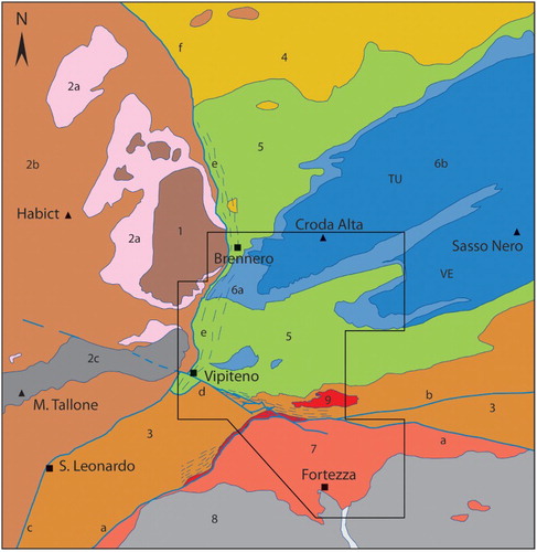
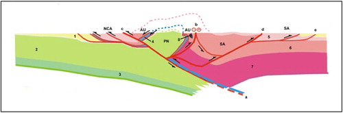
Figure 2. Lithospheric structure of the Eastern Alps along the TRANSALP deep seismic profile: indentation model (CitationCastellarin et al., 2006, modified). (1) Post-collisional outer and inner molasse basins. European lower plate: (2) upper crust and Penninic nappe system (PN) of Tauern Window, (3) lower crust. Oceanic remnants: (4) Ophiolitic Glockner nappe. Adriatic upper plate: Austroalpine Northern Calcareous Alps (NCA) and mainly basement units (AU), Southern Alps (SA): (5) Mesozoic sediments; (6) upper crystalline crust, (7) lower crust. Oligocene igneous bodies: (8) Vedrette di Ries (Rieserferner) pluton. Principal ductile to brittle shear zones and faults: (a) Sub-Tauern ramp, (b) Periadriatic fault, (c) Inntal fault, (d) Valsugana reverse fault, (e) Southalpine frontal thrust. Not to scale.
2.1. Penninic zone
2.1.1. Tux and Venediger-Zillertal nappes
The lowermost tectonic units exposed in the core of the western Tauern Window () are the Penninic Tux and Venediger-Zillertal basement and cover nappes (Zentralgneis and Untereschieferhülle in fixistic Austrian literature), both derived from the European passive continental margin (CitationBistacchi et al., 2004; CitationDal Piaz, 1934; CitationDe Vecchi, & Baggio, 1982; CitationFrisch, 1975, Citation1980; CitationLammerer et al., 2008; CitationRockenschaub et al., 2011). These tectono-metamorphic units display a double domal structure (, north-south cross-section) with fold hinges gently dipping to the west, where they disappear below the Glockner nappe and are crosscut at depth by the Brenner normal fault (CitationBehrmann, 1988; CitationSelverstone, 1988). The basement consists of metagranitoids from Permian protoliths and minor polymetamorphic paraschists (CitationBianchi, 1934; CitationCesare, Rubatto, Hermann, & Barzi, 2002, and refs. therein). The adherent to decollement cover units (CitationBrandner, Reiter, & Töchterle, 2008; CitationFrisch, 1975, Citation1980; CitationRockenschaub et al., 2011) include the siliciclastic, carbonate and evaporitic sequences of the Permian-Triassic Aigerbach Fm ( A-B), dark quartzitic schists with kyanite sheaves (Lower Jurassic?), quartzites and arenaceous marbles (Dogger?), the Hochstegen Marble (Upper Jurassic), and the clastic Kaserer Fm (Cretaceous?).
Figure 3. Tectonic map (A) and block diagram (B, looking west) of Vizze and surrounding areas, modified from CitationDe Vecchi, & Baggio, 1982; (A) Northern (Tux) and Southern (Venediger-Zillertal) antiformal nappe systems: basement (1) and cover (2) units; Ophiolitic Glockner nappe (3); Austroalpine basement unit west of Isarco (4). (B) Tux and Venediger-Zillertal basement (1) and cover units (1.1); Ophiolitic Glockner nappe (2); Austroalpine (3) and Matrei zone (3.1).
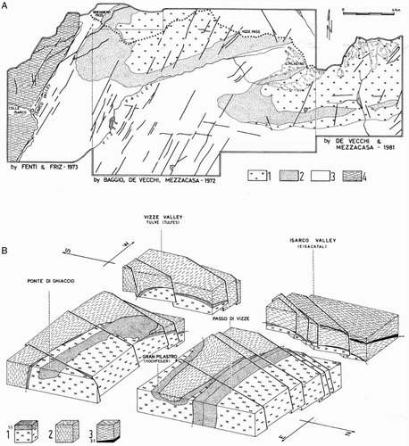
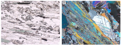
Figure 4. Microphotographs of contrasting metasediments of Aigerbach Fm from Vizze Valley subsurface. (A) Siliciclastic schist with light kyanite (hight relief prisms), bluish chloritoid, white mica and green chlorite, parallel Nicols. (B) Plurimillimetric anhydrite crystals in a dolomite-quartz-phlogopite-chlorite-bearing schist, crossed Nicols.
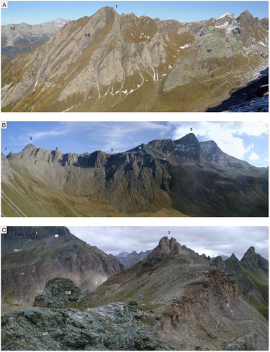
The northern (Tux, Inset 1 A-B) and southern (Venediger-Zillertal, Inset 2 C-D) nappe antiforms are separated by a synform/shear zone (Greiner shear zone Auct., and ), which includes a Late Paleozoic-Eotriassic sequence of siliciclastic-pelitic schists, albitic gneiss, metaconglomerates and slices of serpentinized peridotite (CitationBaggio, De Vecchi, & Mezzacasa, 1982; CitationBehrmann & Frisch, 1990; CitationDe Vecchi & Baggio, 1982). Similar sequences, indicated as the Tulver-Senges unit, reappear in the southern antiform between the lower Vizze and Senges valleys, in two tectonic windows within the Glockner nappe, just below exotic bodies of Triassic carbonates (CitationBistacchi et al., 2004). The substratum of the Tulver-Senges unit is not known yet since it has not been reached by BBT boreholes and the explorative tunnel. Hence, it has been tentatively reconstructed in the north-south profile by projecting of the supposedly laterally continuous core of gneissic granitoids exposed in the Gran Pilastro (Hochfeiler) massif and Fundres Valley, 15 km to the east ((A) and 5(B)).
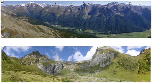
Figure 5. (A) Panoramic view of the Penninic nappe stack along the left slope of high Vizze Valley from Spina del Lupo (Wolfendorn): (i) Tux (TU) and Venediger-Zillertal (VE) basement core (Zentralgneis); (ii) Pfitscher Pass-Hochfeiler unit (GR, Greiner Auct.); (iii) Ophiolitic Glockner nappe (GL). (1) Passo di Vizze, (2) Gran Pilastro (Hochfeiler), (3) San Giacomo (St Jakob), (4) Punta Rossa (Rotes Beil), (5) Felbe, (6) Cima Grava (Grabspitz), (7) Piazza (Platz), (8) Croda della Porta (Torwand), (9) Picco della Croce (Kreuzspitze), (10) Fossa (Fussendross), (11) Monte Grande (Grossbergspitz), (12) Cima di Piambello (Ebengrubenspitz), (13) Cima del Lago (Kramerspitz). (B) Inner flank of the southern nappe antiform in high Fundres Valley, from the bottom up: (i) Venediger-Zillertal granitic gneiss (VE, Zentralgneis); (ii) adherent Hochstegen Marble (HO) at high-angle inclined towards observer; (iii) arenaceous-arkosic gneiss and two-micas gneiss of Pfitscher Pass-Hochfeiler unit (GR, Greiner Auct.). (1) Punta di Dan (Dannelspitz), (2) Picco del Sasso (Magsteinwipfel).
2.1.2. Glockner nappe
The overlying Glockner nappe (Obereschieferhülle Auct.) is derived from the closure of the South-Penninic (CitationBigi et al., 1990; CitationFrisch, 1975) or North-Penninic (CitationSchmid et al., 2013) oceanic branches of the Mesozoic western Tethys (discussed by CitationDal Piaz, 2010). It consists of thick sequences of carbonatic and terrigenous metasediments (Bündnerschiefer, calcschists) with interbeddings of tholeiitic metabasalts from submarine lava flows and sills (CitationDe Vecchi, 1989; CitationDe Vecchi & Baggio, 1982; CitationFrisch, 1980), minor serpentinites, talcschists, ophicalcitic breccias, and scarce massive to mylonitic metagabbros ((A)–6(C)) (CitationBistacchi et al., 2004).
Figure 6. (A) Right side of Montegrande (Grossberg) Valley, Glockner nappe: big lens of serpentinite (SP) inside carbonatic calcschists (CS). (1) M. Grande (Grossbergspitz), (2) Rif. Vipiteno (Sterzing Hütte). (B) South-eastern face of watershed ridge between Valles and Vizze valleys: carbonatic to pelitic calcschists and minor metaophiolites of Glockner nappe. (1) Passo di Fundres (Pfunderer Joch), (2) Cima di Rena (Sandturm), (3) Forcella di Rena (Sandjoch), (4) Metaophiolites, details in Figure C, (5) Picco della Croce. (C) Detail of Forcella di Rena with mylonitic serpentinites (SP) and metagabbro (GB) inside calcschists deformed by D2 isoclinal recumbent folds. (1) Cima Grava, (2) Passo di Fundres, (3) Cima di Rena.
Most metasediments are carbonate-rich calcschists. They include numerous interbeddings of pure and arenaceous grey marbles, minor phyllites and biotite-garnet schists. Saccharoid and arenaceous marbles with chromium-rich mica can be recognized in the Valles Valley, Selvaggio Lake, and south of Mt. Piambello. A terrigenous group, represented by two-micas ± carbonate quartzitic schists, alternating with quartzites, dark phyllites and garnet micaschists, is interbedded with the prevailing carbonate schists. Primary turbiditic sedimentary features are still visible in these rocks despite the Alpine reworking (CitationFrisch, 1978, Citation1980). The Glockner nappe is locally underlain or subdivided into sub-nappes by boudinaged horizons of exotic dolostones, cargneules, arenaceous marbles and siliciclastic deposits (CitationFrisch, 1980; CitationLammerer, Schmidt, & Stadler, 1981) deriving from the European continental-margin or from extensional allochthons trapped in the ocean (CitationBistacchi et al., 2004).
2.2. Austroalpine
The overlying Austroalpine nappe system outcropping south of the western Tauern Window ( and ) is represented by the polymetamorphic Merano-Mules complex and minor remnants of its Permian-Triassic metasedimentary cover (CitationBaggio et al., 1969; CitationBistacchi et al., 2004; CitationBorsi, Del Moro, Sassi, & Zirpoli, 1978; CitationBrandner et al., 2008; CitationFritz, Krenn, & Kurz, 2003; CitationSassi, Zanferrari, Zirpoli, Borsi, & Del Moro, 1974; CitationSpiess, Cesare, Mazzoli, Sassi, & Sassi, 2010). The basement extends from the Sprechenstein Castle to the Mules Lamella (tectonic contact) and the Valles Valley, where it is intruded and thermally metamorphosed by the Oligocene Rensen Pluton. It consists of (i) fine-grained paragneiss (plagioclase, quartz, biotite, muscovite ± garnet), (ii) banded gneiss with multiple thin beds of quartzites, pegmatites, old marbles and bodies of metagranitoids to augengneiss, and (iii) amphibolites with local gabbro relics (Senges Valley). The older amphibolite-facies fabric is relatively well preserved in lenticular low-strain domains mantled by strongly deformed and retrogressed Alpine tectonites (low grade phyllonites, mylonites and cataclastic fault rocks), becoming dominant along major tectonic lines and particularly along the Periadriatic System (CitationBistacchi et al., 2004, Citation2010).
The Permian-Mesozoic metasedimentary cover is represented by a kilometric body exposed in the lower Mules valley and few strongly deformed slices in the middle and upper part of the same valley. The siliciclastic basal sequence consists of quartzitic beds grading to metaconglomerates (Permian-Eotriassic). The overlying dolomitic sequence includes the Reichenall Beds (Anisian), Alberg Fm (Ladinian-Carnian), and Raibl Group (Carnian).
The outcrops of Austroalpine basement included in the western border of our map, on the left side of the Isarco River, north of Vipiteno, belong to the Ötztal complex (CitationBigi et al., 1990; CitationBrandner et al., 2008), and are representative of the hanging wall of the low-angle Brenner normal fault.
2.3. Oligocene igneous bodies
The Oligocene Periadriatic magmatism (CitationBigi et al., 1990; CitationExner, 1976; CitationDal Piaz, Del Moro, Martin, & Venturelli, 1988; CitationRosenberg, 2004) is represented in our map (from north to south) by few dacitic-andesitic dykes (CitationMancktelow, Stöckli, Grollimund, Müller, Fügenschuh, Viola, Seward, & Villa, 2001; CitationScolari & Zirpoli, 1972), the western part of the Rensen Pluton (CitationBellieni, Cavazzini, Fioretti, Peccerillo, & Poli, 1991; CitationBorsi et al., 1978; CitationFritz et al., 2003; CitationMüller, Prosser, Mancktelow, Villa, Kelley, Viola, & Aerli, 2001), and the Mules Lamella (CitationBaggio et al., 1969; CitationBistacchi et al., 2004) (). The E-W-trending, subvertical to high-angle Oligocene dykes are unconformably emplaced within both the Austroalpine basement and calcschists of the Glockner nappe, near their backfolded tectonic contact (): these relationships point out that the prominent antiformal doming of the Austroalpine-Penninic nappe stack (CitationCastellarin et al., 2006; CitationLammerer et al., 2008; CitationLüschen, E., Lammerer, B., Gebrande, H., Millahn, K., Nicolich, R., & TRANSALP Working Group, 2004) and related backfolding were already developed in the Oligocene (CitationBistacchi et al., 2004), and that they are not a Miocene feature (as e.g. in CitationFügenschuh, Seward, & Mancktelow, 1997; CitationSchmid et al., 2013).
The Rensen pluton is composed of massive to foliated granodiorite and minor tonalite, and developed a discrete contact aureole in the surrounding Austroalpine micaschists and marbles. The Mules Lamella consists of massive to foliated and cataclastic tonalite and minor diorite-gabbro bodies. It displays a subvertical attitude and is bounded by tectonic lines of the Periadriatic system. A primary intrusive contact of the western extension of the Mules Lamella into the Merano-Mules basement is locally preserved along the right slope of the Isarco valley, confirming that the Mules Lamella is not the border zone of the Southalpine Bressanone granite (CitationBaggio et al., 1969), and that it was independently emplaced in the inner Austroalpine domain (CitationBistacchi et al., 2004).
2.4. Southern Alps
The retro-wedge crystalline basement of the Adria-vergent Southern Alps (CitationCastellarin et al., 2006; CitationCuffaro, Riguzzi, Scrocca, Antonioli, Carminati, Livani, & Doglioni, 2010; CitationSpiess et al., 2010) is represented in the mapped area by the Permian Bressanone Granite (CitationDel Moro & Visonà, 1982), minor gabbros (Inset 4) and some roofing quartz-phyllites, the latter showing Variscan greenschist facies metamorphism (CitationBaggio et al., 1969). To the north the pluton is bounded by the North-Giudicarie and Pusteria lines of the Periadriatic System, whereas to the south the basement is overlain by Permo-Mesozoic cover units of the Dolomites (not included in our map).
3. Tectonic evolution
We describe the main structural features in the Tauern Window, from older to younger ones. Since these structures developed during the Alpine collision and subsequent exhumation, brittle lower-temperature structures systematically post-date the ductile syn-metamorphic ones. The large-scale ductile structures represented in the geological cross-section are the result of at least four deformation phases (D1 to D4).
D1 is associated with a S1 metamorphic foliation just preserved in low-strain domains (generally hinge zones) with respect to younger deformations. The L1 stretching lineation dips to the west at 30–40° (in contrast with sub-horizontal L2). In the Aigerbach Fm, S1 is marked by quartz-chlorite-chloritoid-kyanite ((A)), indicating relatively high-pressure conditions, not detected in other units if we exclude the pseudomorphs after lawsonite in the metabasalt pods to the north of the Gran Pilastro (CitationSelverstone, 1988). No large-scale D1 structures are known.
The regionally dominant foliation S2 is characterized by amphibolite to high-T greenschist facies mineral assemblages (CitationDe Vecchi & Baggio, 1982; CitationMorteani & Raase, 1974; CitationOberhänsli et al., 2004); the L2 stretching lineation is east-west subhorizontal and it is marked by biotite-kyanite and/or hornblende. D2 folds are generally isoclinal, have east-west subhorizontal axes and axial surfaces that were folded during D3. Large-scale D2 structures are common. In the European cover units and ophiolitic Glockner nappe, older fabrics were almost completely reworked and transposed during D2. However, in the stiffer Tux and Venediger-Zillertal gneissic core a composite D1-D2 fabric prevails, with a S1 foliation reworked by D2 mylonites and penetrative shear bands.
A static recrystallization phase developed between D2 and D3, evidenced by the growth of characteristic Garbenschiefer (coarse-grained sheaf-like aggregates of hornblende or kyanite in silvery micaschists, paragneiss, and amphibolites).
D3 is represented by open to tight folds at all scales, with asymmetric “S” and “Z” geometry on opposed limbs. Fold axes are east-west subhorizontal and axial surfaces dip at intermediate to high angles towards the north, resulting in type-III (CitationRamsay, 1962) interference patterns with S2 folds. The S3/L3 foliation and stretching lineation are pervasively developed only in the Greiner synformal shear zone, interposed between the basement-cored Tux and Venediger-Zillertal antiforms. S3 and L3 are characterized by low-T greenschist facies mineral assemblages, and cracking or micro-boudinage of higher temperature phases.
D4 is responsible for the final backfolding of the southern part of the Tauern window ( and north-south profile). This deformation is particularly localized in the southern margin of the window, at the boundary between the Glockner and Austroalpine nappes, which is characterized by a large-scale D4 shear zone with east-west subhorizontal stretching lineation and a sinistral kinematics. Based on similar metamorphic conditions and kinematics, D4 could be tentatively associated to the only penetrative Alpine deformation developed in the Austroalpine, represented by the large-scale Defereggen-Anterselva-Valles (DAV) shear zone (CitationDal Piaz, 1934; CitationMancktelow et al., 2001; ). In any case the sinistral D4 fabrics predate the Oligocene dacitic-andesitic dykes cited above (e.g. outcrops at Malga Fana; CitationScolari & Zirpoli, 1972).
The regional-scale exhumation of the Tauern window associated to the extensional activity of the Brenner Fault Zone (CitationBehrmann, 1988; CitationBistacchi, Massironi, Menegon, Bolognesi, & Donghi, 2012; CitationMassironi, Bistacchi, & Menegon, 2011; CitationSelverstone, 1988) resulted in cooling of the Penninic units and transition from ductile to brittle deformations. This is evidenced by a penetrative west-dipping, top-down SC fabric developed in the ridge between Vipiteno and Spina del Lupo, corresponding to the footwall of the Brenner Line, which is hidden by Quaternary deposits in the Isarco valley (small outcrops around Vipiteno and the Brenner Pass).
To the east of the Brenner Fault Zone, several high-angle brittle faults have been mapped, showing a normal-sinistral kinematics compatible with the final stage of the east-west extension associated with the Brenner Fault Zone. As already evidenced by CitationDe Vecchi, & Baggio, 1982, , these normal faults preferentially dip to the west, developing a megascopic staircase structure where deeper structural levels (e.g. the southern nappe antiform) are progressively revealed to the east.
East-west extension along the north-south Brenner Line is kinematically compatible with the dextral kinematics observed along the Periadriatic Fault System. This is composed, in the map area (), by the Pusteria (Pustertal) and Sprechenstein-Mules Fault Zones (CitationBistacchi et al., 2004, Citation2010). The Pusteria Fault is the most important brittle feature in the area, and separates the Austroalpine (or the Mules Lamella) from the Southern Alps. It is an almost vertical fault zone, some hundred metres thick, characterized in the core zone by green cataclasites (cemented by hydrothermal quartz and epidote) and black ultracataclasites (extremely fine-grained quartz and plagioclase clasts within a clayey matrix). The offset cannot be precisely measured, but it could be in the order of several km (e.g. CitationFrisch et al., 2000).
The WNW-ESE, NNE-dipping Sprechenstein-Mules Fault offsets the Pusteria Fault and connects it with the Brenner Line near Vipiteno (CitationBistacchi et al., 2004, Citation2010, ). This fault is characterized by an array of contractional jogs, which can be reconstructed in details since they offset the Mules Lamella and the Permian-Mesozoic cover units (CitationBistacchi et al., 2010). The Sprechenstein-Mules Fault shows a 1.5 km dextral-reverse net slip.
Finally, the Bressanone granite is crosscut by a multitude of fault systems with different kinematics. This is not surprising because it was deformed during continental rifting and represented the innermost buttress of the Southern Alps for a very long time, during the whole Alpine orogeny. Unfortunately, due to the absence of diagnostic features, it is not possible to attribute these structures to meaningful tectonic phases and their specific role remains uncertain.
4. Quaternary deposits and geomorphology
The tectonic setting and evolution have strongly influenced the shape and topography of the mapped area, resulting in a marked morphological difference across the Periadriatic Fault System: the Austroalpine-Penninic nappe stack to the north is characterized by high reliefs and active erosive processes ( and ); in contrast the Bressanone granite to the south is a plateau mainly covered by glacial deposits.
The Quaternary is dominated by glacial, periglacial and gravitational deposits, with thick alluvial sediments only along the Isarco, Vizze ((A)) and Valles valleys. Glacial deposits span from the Late Glacial Maximum to the Younger Dryas (CitationAstori & Venturini, 2011, details and refs. therein), whereas the Little Ice Age moraines are limited to the base of the highest peaks bordering the Vizze and other valleys ( and ). Periglacial deposits like rock-glaciers and/or debris-covered glaciers are common just in the right slope of the Vizze valley between the Wolfendorn and the Hoe Wand ((B)).
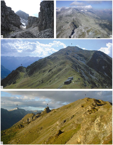
Figure 7. Gravitational slope and bilateral ridge deformations in Vizze Valley. (A) Deep and large trench within Mesozoic metasediments of Tux antiform north-east of Spina del Lupo (Wolfendorn). (B) View of the same trench from Spina del Lupo. (C) Bilateral gravitational morpho-structures of Glockner nappe calcschists of Giogo di Trens (Höllenkragen), south facing. (1) Giogo di Trens, (2) Passo di Trens (Trenser Joch), (3) Jagerjöchl.( D) Deformed summit and western hillside of Cima del Cavo, north-east of Passo di Trens. (1) Cima Stella, (2) Cima del Cavo, (3) Spina del Lupo.
Gravitational deposits mainly include talus slopes and cones, and rock-falls. Amongst the mixed gravitational-alluvial deposits, ubiquitous along the main valleys, the debris flows running towards the Isarco valley within the deep fault-related incisions in the Bressanone granite are worth mentioning for their relevance and hazard.
Glacial, fluvio-glacial, alluvial-lacustrine, and gravitational deposits are particularly interesting in the middle Vizze Valley ((A)), which was occluded by a huge rockfall detached from the Cima del Cavo (Avenes palaeo-landslide, CitationBistacchi et al., 2004), and afterwards recorded two glacial-interglacial episodes (CitationAstori & Venturini, 2011).
The geometrical relationships between foliations, faults and slopes are of primary relevance for Deep Seated Gravitational Slope Deformations (DSGSD) and large-scale mass-movements (CitationBistacchi et al., 2004; CitationMassironi et al., 2003). The right slope of the high Vizze valley, shaped in the granitic gneiss along the southern sub-vertical limb of the Tux antiform, is affected by lateral spreading and mega-toppling processes (Inset 2 A). Further to the west, along the Spina del Lupo ridge, the cover metasediments of the Tux hinge are cut by gigantic trenches ((A) and 7(B)), whereas the underlying southern slope displays sackung-type DSGSDs, where it encounters the subvertical contact with these metasediments. Conversely, the more articulated left slope in the middle and lower Vizze Valley ((A)) obliquely intersect the Venediger-Zillertal antiform and for a relevant part follows a NNE-SSW fault. The interplay between these two structures and the slope results in complex gravitational deformations involving the entire ridge Monte Casaclusa-Giogo di Trens-Cima del Cavo (CitationBistacchi et al., 2004; CitationMassironi et al., 2003). The southernmost sector (Monte Casaclusa-Giogo di Trens, (C)) is deformed by active lateral spreading acting on the subvertical foliation of the Venediger-Zillertal antiform back-limb; the middle sector (Giogo di Trens-Cima Stella, (D)) with gently dipping foliation in the hinge zone, is characterized by a sackung-type DSGSD; finally at Cima del Cavo the interaction of faults with the steeply north-dipping foliation generated the huge Avenes palaeo-rockfall. Important DSGSDs developed also from the Monte Casaclusa-Giogo di Trens ridge towards the Isarco valley where rock-slide deposits have been documented.
5. Discussion and conclusion
This mapping project, carried out on a very large area (360 km2), surveyed at a very detailed scale (1:10,000-1:5000) and accompanied by systematic structural analysis, attains original results on (i) the Alpine structural setting of the Austroalpine-Penninic wedge, Southalpine basement and polyphase tectonic evolution at the regional scale, and (ii) the relationships between the structural features of bedrock and gravitational slope deformations.
Considering the tectonic evolution of the western Tauern Window, we have unravelled the relative chronology of ductile deformations, constraining the end of the last ductile deformation in the Oligocene (in agreement with CitationMancktelow et al., 2001), and reconstructed the post-Oligocene fault network, including the Periadriatic System.
5.1. Software
The geological dataset was implemented within Esri ArcGIS using additional database management software developed in-house using in Visual Basic (Db_collector; mdb file format). The latter was used to integrate within a single database all information collected at specific measurement stations. The geometric primitives and alphanumeric attributes of interest for map production were extracted as a shp file from the Esri geodatabase. These features were imported into the Adobe Illustrator with MAPublisher. Adobe Illustrator was used for the final cartographic layout.
Geological map of the Brenner Pass-Fortezza transet, Italian eastern Alps (Scale 1:30,000)
Download PDF (40.3 MB)Geological map of the Brenner Pass-Fortezza transet, Italian eastern Alps (Scale 1:30,000)
Download PDF (19.6 MB)Acknowledgements
We acknowledge BBT-SE for funding the field and laboratory work of the CFR project, providing the topographic maps and authorization to publish our scientific results. E. Fontana, B.J. Kronenfeld, P. Scandone are acknowledged for their careful reviews. Irene Vigni is thanked for her technical assistance.
Related Research Data
References
- Astori, A., & Venturini, C. (2011). Evoluzione quaternaria della media Val di Vizze-Pfitschtal (Vipiteno, Bz – Alpi Aurine). Gortania, 32, 63–92.
- Baggio, P., Bosellini, A., De Vecchi, Gp. et al. (1969). Carta Geologica d'Italia 1:100.000, F. 1-4, Passo del Brennero-Bressanone e Note illustrative. Serv. Geol. It., 1–120.
- Baggio, P., De Vecchi, Gp., & Mezzacasa, G. (1982). Carta geologica 1:25.000 media ed alta Valle di Vizze e regioni vicine (Alto Adige). CNR Padova, in De Vecchi & Baggio, 1982.
- Behrmann, J. H. (1988). Crustal-scale extension in a convergent orogen: The Sterzing-Steinach mylonite zone in the Eastern Alps. Geodynamica Acta, 2, 63–73.
- Behrmann, J., & Frisch, W. (1990). Sinistral ductile shearing associated with metamorphic decompression in the Tauern Window, Eastern Alps. Jahrbuch der Geologisches Bundes-Anstalt, 133, 135–146.
- Bellieni, G., Cavazzini, G., Fioretti, A. M., Peccerillo, A., & Poli, G. (1991). Geochemical and isotopic evidence for crystal fractionation, AFC and crustal anatexis in the genesis of the Rensen plutonic complex (Eastern Alps, Italy). Chemical Geology, 92, 21–43. doi: 10.1016/0009-2541(91)90048-V
- Bianchi, A. (1934). Studi petrografici sull'Alto Adige orientale e regioni limitrofe. Mem. Istituto Geologia Univ. Padova, 10, 1–240.
- Bigi, G., Castellarin, A., Coli, M., Dal Piaz, G. V., Sartori, R., Scandone, P., & Vai, G. B. (1990). Structural model of Italy scale 1:500.000, sheet 1. C.N.R., Progetto Finalizzato Geodinamica, SELCA Firenze.
- Bistacchi, A., Dal Piaz, G. V., Dal Piaz, G., Massironi, M., Monopoli, B., & Schiavo, A. (2004). Carta geologica e note illustrative del transetto Val di Vizze-Fortezza (Alpi orientali). Memorie Scienze Geologiche, 55(2003), 169–188.
- Bistacchi, A., Massironi, M., Dal Piaz, G. V., Dal Piaz, G., Monopoli, B., Schiavo, A., & Toffolon, G. (2007). 3D fold and fault reconstruction with an uncertainty model: An example from an Alpine tunnel case study. Computers & Geosciences, 1–19. doi:10.1016/j.cageo.2007.04.002
- Bistacchi, A., Massironi, M., & Menegon, L. (2010). Three-dimensional characterization of a crustal-scale fault zone: The Pusteria and Sprechenstein fault system (Eastern Alps). J. Structural Geology, 32, 2022–2041. doi:10.1016/j.jsg.2010.06.003
- Bistacchi, A., Massironi, M., Menegon, L., Bolognesi, F., & Donghi, V. (2012). On the nucleation of non-Andersonian faults along phyllosilicate-rich mylonite belts. Geological Society Special Publication, 367(1), 185–199. doi:10.1144/SP367.13
- Borsi, S., Del Moro, A., Sassi, F. P., & Zirpoli, G. (1978). On the age of the periadriatic rensen massif (Eastern Alps). N. Jb. Geol. Pal. Mh., 5, 267–272.
- Brandner, R., Reiter, F., & Töchterle, A. (2008). Ueberblick zu den ergebnissen der geologischen Vorerkundung für den Brenner-Basistunnel. GeoAlp, 5, 165–174.
- Castellarin, A., Nicolich, R., Fantoni, R., Cantelli, L., Sella, M., & Selli, L. (2006). Structure of the lithosphere beneath the Eastern Alps (southern sector of the TRANSALP transect). Tectonophysics, 414, 259–282. doi:10.1016/j.tecto.2005.10.013
- Cesare, B., Rubatto, D., Hermann, J., & Barzi, L. (2002). Evidence for late carboniferous subduction-type magmatism in mafic-ultramafic cumulates from SW Tauern Window (Eastern Alps). Contribution Mineral Petrology, 142, 449–464. doi:10.1007/s004100100302
- Cuffaro, M., Riguzzi, F., Scrocca, D., Antonioli, F., Carminati, E., Livani, M., & Doglioni, C. (2010). On the geodynamics of the northern Adriatic plate. Rend. Fis. Acc. Lincei, 21, suppl. 1, S253–S279. doi:10.1007/s12210-010-0098-9
- Dal Piaz, Gb. (1934). Studi geologici sull'Alto Adige orientale e regioni limitrofe. Mem. Istituto Geologia Univ. Padova, 10, 245.
- Dal Piaz, G. V. (2010). The Italian Alps: A journey across two centuries of Alpine geology. In M. Beltrando, A. Peccerillo, M. Mattei, S. Conticelli & C. Doglioni (Eds.), The geology of Italy: Tectonics and life along plate margins. Journal of the Virtual Explorer, electronic edition, 36/8, 1–108. doi:10.3809/jvirtex.2010.00234.
- Dal Piaz, G. V., Bistacchi, A., & Massironi, M. (2003). Geological outline of the Alps. Episodes, 26/3, 175–180.
- Dal Piaz, G. V., Del Moro, A., Martin, S., & Venturelli, G. (1988). Post-collisional magmatism in the Ortler-Cevedale massif (Northern Italy). Jahrbuch der Geologisches Bundes-Anstalt, 131, 533–551.
- Del Moro, A., & Visonà, D. (1982). The epiplutonic Hercynian complex of Bressanone (Brixen, Eastern Alps, Italy). Petrologic and radiometric data. N. Jb. Min. Abh., 145, 66–85.
- De Vecchi, Gp. (1989). Metaophiolite suite in the South-Western Tauern Window (Italian sector), Geochemistry and geological setting. Memorie Scienze Geologiche, 41, 51–59.
- De Vecchi, Gp., & Baggio, P. (1982). The Pennine zone of the Vizze region in the western Tauern window (Italian eastern Alps). Boll. Società Geologica Italiana, 101, 89–116.
- Exner, Ch. (1976). Die geologische Position der Magmatite des Periadriatischen Lineaments. Verh. Geologisches Bundes-Anstalt, 1976, 3–64.
- Frisch, W. (1975). Die stratigraphisch-tektonische Gliederung der Schieferhülle und die Entwicklung des penninischen Raumes in Westlichen Tauernfenster (Gebiet Brenner-Gerlopass). Mitt. öesterr. geol. Ges., 66–67, 9–20.
- Frisch, W. (1978). A plate tectonics model of the Eastern Alps. In H. Closs, D. Roeder & K. Schmidt (Eds.), Alps Apennines Hellenides. Inter-Union Comm. Geodynamics, Sci. Report, 38, 167–172.
- Frisch, W. (1980). Post-Hercynian formations of the western Tauern window: Sedimentological features, depositional environment, and age. Mitt. österr. geol. Ges., 71–72, 49–63.
- Frisch, W., Dunkl, I., & Kuhlemann, J. (2000). Post-collisional orogen parallel large-scale extension in the Eastern Alps. Tectonophysics, 327, 239–265. doi: 10.1016/S0040-1951(00)00204-3
- Fritz, H., Krenn, K., & Kurz, W. (2003). Tectonics, metamorphism and magma generation between Periadriatic lineament and Tauern window (Vals valley, close to Transalp traverse). 5th Workshop of Alpine Geological Studies, Field trip guide E6, Geol. Pal. Mitt. Innsbruck, 26, 61–69.
- Fügenschuh, B., Seward, D., & Mancktelow, N. S. (1997). Exhumation in a convergent orogen: The western Tauern window. Terra Nova, 9, 213–217. doi:10.1111/j.1365-3121.1997.tb00015.x
- Gruppo di Ricerca BBT. (2006). Rapporto Definitivo D0104, Cartografia geologico-strutturale e studi geologici complementari. Consorzio Ferrara Ricerche (CFR), Geologische Bundesanstalt (GBA), Universität Innsbruck (UIBK), unpublished report to BBT-SE, May 31th 2006, 1116 p. and maps.
- Kummerow, J., Kind, R., Oncken, O., Giese, P., Ryberg, T., Wylegalla, K., Scherbaum, F., & TRANSALP Working Group. (2004). A natural and controlled profile through the Eastern Alps: TRANSALP. Earth and Planetary Science Letters, 225, 115–129. doi:10.1016/j.epsl.2004.05.040
- Kurz, W., Neubauer, F., Genser, J., & Dachs, E. (1998). Alpine geodynamic evolution of passive and active continental margin sequences in the Tauern Window (Eastern Alps, Austria, Italy): A review. Geol. Rundschau, 87, 225–242. doi: 10.1007/s005310050204
- Lammerer, B., Gebrande, H., Lüschen, E., & Vesela, P. (2008). A crustal-scale cross-section through the Tauern Window (eastern Alps) from geophysical and geological data. Geological Society of London special publications, 298, 219–229. doi:10.1144/SP298.11
- Lammerer, B., Schmidt, K., & Stadler, R. (1981). Zur Stratigraphie und Genese der penninisches Gesteinen des Südwestlichen Tauernfenster. N. Jb. Geol. Pal. Mh., 11, 678–696.
- Lammerer, B., & Weger, M. (1998). Footwall uplift in an orogenic wedge: The Tauern Window in the Eastern Alps of Europe. Tectonophysics, 285, 213–230. doi: 10.1016/S0040-1951(97)00272-2
- Lüschen, E., Lammerer, B., Gebrande, H., Millahn, K., Nicolich, R., & TRANSALP Working Group. (2004). Orogenic structure of the Eastern Alps, Europe, from TRANSALP deep seismic reflection profile. Tectonophysics, 388, 85–102. doi:10.1016/j.tecto.2004.07.024
- Mancktelow, N., Stöckli, D. F., Grollimund, B., Müller, W., Fügenschuh, B., Viola, G., Seward, D., & Villa, I. M. (2001). The DAV line and Periadriatic fault system in the Eastern Alps south of the Tauern window. International Journal of Earth Sciences, 90, 593–622. doi:10.1007/s005310000190
- Massironi, M., Bistacchi, A., Dal Piaz, G. V., Monopoli, B., & Schiavo, A. (2003). Structural control on mass-movement evolution: A case study from the Vizze Valley, Italian Eastern Alps. Eclogae Geol. Helv., 96, 85–98.
- Massironi, M., Bistacchi, A., & Menegon, L. (2011). Misoriented faults in exhumed metamorphic complexes: Rule or exception? Earth and Planetary Science Letters, 307(1–2), 233–239. doi:10.1016/j.epsl.2011.04.041
- Morteani, G., & Raase, P. (1974). Metamorphic plagioclase crystallization and zones of equal anorthite content in epidote-bearing, amphibole-free rocks of the western Tauernfenster (Eastern Alps). Lithos, 7, 101–111. doi: 10.1016/0024-4937(74)90023-1
- Müller, W., Prosser, G., Mancktelow, N., Villa, I., Kelley, S., Viola, G., & Aerli, F. (2001). Geochronological constraints on the evolution of the Periadriatic Fault system (Alps). International Journal of Earth Sciences, 90, 623–653. doi:10.1007/s005310000187
- Oberhänsli, R., Bousquet, R., Engi, M., Goffé, B., Gosso, G., Handy, M., et al. (2004). Metamorphic structure of the Alps. Paris, Commission for the Geological Map of the World.
- Ramsay, J. G. (1962). Interference patterns produced by the superposition of folds of similar type. Journal of Geology, 70(4) 466–481. doi: 10.1086/626837
- Rockenschaub, M. et al. (2011). Geologische Karte der Republik Oesterreich 1:50.000, 175 Sterzing. Geologische Bundesanstalt, Wien.
- Rosenberg, C. L. (2004). Shear zones and magma ascent: A model based on a review of the Tertiary magmatism in the Alps. Tectonics, 23, 1–21. doi:10.1029/2003TC001526
- Sassi, F. P., Zanferrari, A., Zirpoli, G., Borsi, S., & Del Moro, A. (1974). The Austrides to the south of the Tauern window and the Periadriatic lineament between Mules and Mauthen. N. Jb. Geol. Pal. Mh., 7, 421–435.
- Schmid, S. M., Scharf, A., Handy, M. R., & Rosenberg, C. L. (2013). The Tauern Window (Eastern Alps, Austria): A new tectonic map, with cross-sections and a tectonometamorphic synthesis. Swiss Journal Geosciences, 106, 1–32. doi:10.1007/s00015-013-0123-y
- Scolari, A., & Zirpoli, G. (1972). Filoni tardoalpini metamorfici negli scisti austridici e pennidici della Val di Valles (Alto Adige). Memorie Istituti Geologia e Mineralogia dell'Università di Padova, 29, 1–32.
- Selverstone, J. (1988). Evidence for east-west crustal extension in the Eastern Alps: Implications for the unroofing history of the Tauern window. Tectonics, 7, 87–105. doi:10.1029/TC007i001p00087
- Spiess, R., Cesare, B., Mazzoli, C., Sassi, R., & Sassi, F. P. (2010). The crystalline basement of the Adria microplate in the eastern Alps: A review of the palaeostructural evolution from the Neoproterozoic to the Cenozoic. Rend. Fis. Acc. Lincei, 21(Suppl. 1), 31–50. doi:10.1007/s12210-010-0100-6