
Abstract
This paper presents the outcomes of a geomorphological investigation carried out along the coasts of the island of Malta and provides a detailed classification of the Maltese coastline based on the identification and definition of specific coastal geomorphotypes. The results of field surveys, supported by air-photo interpretation, have led to the production of a coastal geomorphological map at 1:30,000 scale which outlines the processes and related deposits and landforms. The latter are the result of the complex interplay of structural, gravitational, coastal and karst processes. Moreover, radiocarbon dates of marine organisms encrusted on boulders mapped along the NE coast are presented.
1. Introduction
The coastline of the island of Malta is 196 km long and dominated by vertical cliffs, indented bays, cliffy coves and inlets developed on limestone formations (CitationFurlani, Pappalardo, Gomez-Pujol, & Chelli, 2014). Maltese coasts were first described and classified by CitationPaskoff and Sanlaville (1978) and by CitationMagri (2006) and recently revised by CitationSaid and Schembri (2010).
This work offers a detailed classification of the coastal landscape through the classification of coastal geomorphotypes, which are defined by specific topographical, lithostructural and geomorphological features. It presents a 1:30,000 geomorphological map of the coastal areas. The map extends up to 500–1000 m inland in order to represent landforms and deposits derived from marine, karst, fluvial and gravitational processes.
2. Structural and geological setting of the island of Malta
The Maltese archipelago is a group of central Mediterranean Islands located about 96 km from Sicily and 290 km from North Africa, at a latitude of 35°48′28″ to 36°05′00″ North and a longitude of 14°11′04″ to 14°34′37″ East. They are situated on a shallow shelf, the Malta-Ragusa Rise, part of the submarine ridge which extends from the Ragusa peninsula (Sicily), southwards to the North African coasts of Tunisia and Libya. The total area is 316 km² with the largest island Malta (246 km²) having the administrative capital, Valletta. The other islands, Gozo (67 km²) and Comino (3 km²), together with a small number of uninhabited islets and rocks complete the archipelago. The Island of Malta lies in the Sicily Channel, which was affected during the Neogene-Quaternary (CitationDart, Bosence, & Mcclay, 1993; CitationFinetti, 1984) by continental rifting. It produced extensive structures, such as the Pantelleria, Malta and Linosa tectonic depressions, which are controlled by NW-SE normal faults ((a)).
Figure 1. (a) Geodynamical setting redrawn from CitationGalea (2007) on a SRTM map (http://srtm.csi.cgiar.org); (b) Geological map of Malta (redrawn from CitationOED, 1993).
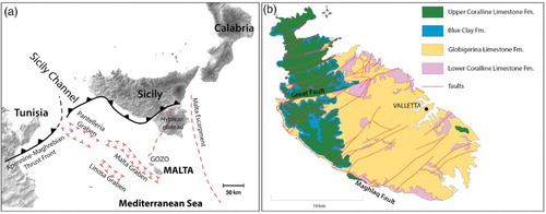
The tectonic setting of Malta is characterized by two graben systems. The oldest, ENE-WSW oriented, has been active since the early Miocene and caused the development of a horst and graben system, which is characterized by alternating highlands and lowlands (CitationAlexander, 1988).
The above-mentioned tectonic structures are crossed by faults belonging to the Pantelleria Rift, NW-SE oriented, which developed during the late Miocene and early Pliocene (CitationReuther & Eisbacher, 1985). The Neogene-Quaternary uplift caused by the Pantelleria Rift is responsible for the emergence and subsequent tilting towards the NNE of the island (CitationAlexander, 1988), with a resulting downlift of its eastern flanks. This tectonic development – with relatively higher topography and steep coasts along the western side of Malta and low-lying coasts along the eastern side – also influenced the hydrological catchment of the islands during the pluvial Quaternary period with fluvial channels draining heavily from a WSW to NNE direction, inducing more intense fluvio-coastal erosion in the eastern part and the removal of large volumes of the stratigraphic sequence in the lower topographic regions.
Malta is formed by sedimentary rocks, deposited in shallow marine conditions between the late Oligocene and Miocene (CitationPedley, Clarke, & Galea, 2002; CitationPedley, House, & Waugh, 1976; (b)). The bedding is mainly horizontal or sub-horizontal.
The stratigraphic sequence starts with the Lower Coralline Limestone Formation (Upper Oligocene: Chattian, thickness: 140 m), which is characterized by bioclastic, bedded, grey limestones. It is followed by the soft and yellowish Globigerina Limestone Formation (late Oligocene – middle Miocene: late Chattian – Langhian, thickness: 20–207 m, CitationBaldassini, Mazzei, Foresi, Riforgiato, & Salvatorini, 2013; CitationGiannelli & Salvatorini, 1972) which is composed of massive fine-grained biomicrites. The sequence continues with the Blue Clay Formation (middle Miocene: late Langhian – early Tortonian, thickness: 20–75 m), mostly formed by alternating layers of dark-grey and pale-grey marls. The upper part of the sequence is made up of the Upper Coralline Limestone Formation (Upper Miocene: late Tortonian – early Messinian, thickness: 10–170 m), which is similar to the oldest carbonate unit (CitationPedley et al., 1976). Pockets of fluvial Quaternary deposits consisting of continental sequences are also present, mainly concentrated along the coastal sectors of the island as valley loams, breccias or fossiliferous deposits (CitationTrenchmann, 1938) or as thin near-surface deposits, such as red soils and colluvial sediments (CitationPedley, 2011).
3. Methods
A detailed-scale geomorphological analysis allowed for the identification, classification and spatial distribution of coastal landforms of Malta Island. It is the result of 1:10,000 scale field survey supported by the interpretation of tens of 1:4000 scale photos taken from a low-flying aircraft in 2008. The north-western part of the island has previously been studied during field surveys aiming at landslide recognition and detailed geomorphological mapping (CitationDevoto et al., 2012, Citation2013; CitationMagri, Mantovani, Pasuto, & Soldati, 2008; CitationMantovani et al., 2013). The work has been extended to the whole coastline, up to about 500 to 1000 m inland, to classify and map the rocky coasts and their geomorphological features (CitationBiolchi, 2013).
The resulting map of the Maltese costal sector consists of two main sections (Main Map):
the main geomorphological map draped over a Digital Terrain Model (DTM) and related legend (centre and left slice of the map);
a sketch map with the distribution of coastal geomorphotypes and the location of the storm wave/tsunami deposits (upper right side of the map) with a grey-scale slope map used as background.
Field surveys and air-photo interpretation allowed integration and refinement of the lithological and structural features of the previous geological maps (CitationOil Exploration Directorate, 1993). Field mapping and symbolization followed convention according to the guidelines of the Geological Survey of Italy (CitationGruppo di Lavoro per la Cartografia Geomorfologica, 1994) and conforming to the geomorphological map produced by CitationDevoto et al. (2012). More precisely, the raster shown on the map is a hillshade generated from the DTM, which was derived from high-resolution aerial laser scan (ALS) data.
Radiocarbon dates were calculated by the Centre for Dating and Diagnostics (CEDAD) of the University of Salento on samples collected on three boulders surveyed on the NE coast.
4. Results
4.1. The geomorphotypes of the Maltese coasts
Following CitationPaskoff and Sanlaville (1978) and CitationSaid and Schembri (2010), the rocky coastline of Malta has been classified in seven coastal geomorphotypes, which are characterized by peculiar topographical, lithostructural and geomorphological features:
Plunging cliff: vertical or sub-vertical cliff descending into a considerable depth far below low-tide level without any development of shore platform or ramp (CitationSunamura, 1992) ((a));
Sloping coast: low-lying rocky coast with slope dips ranging between 5° and 45° ((b));
Shore platform: from horizontal to sub-horizontal rock surface (0–5°) produced along a shore by the action of marine processes (wave erosion, biogeochemical dissolution and other weathering processes) and the retreat of a cliff in the intertidal zone (CitationTrenhaile, 1987) ((c)). Shore platforms can be observed at the intertidal level or 5–10 m above sea level. The latter developed on bedding planes, following their slope, they are never submerged but are affected by wave action and marine spray. Their shape corresponds to shore platform type B (CitationSunamura, 1992). Usually, a deeply carved abrasional notch occurs at mean sea level;
Screes: this scenery is locally called rdum (CitationSaid & Schembri, 2010) and is characterized by extensive slope-failure deposits, which are located between coastline and karst plateaus. Landslide accumulations cover the clayey terrains and consist of chaotic and heterogeneous blocks moved mainly by extremely slow-moving landslides such as rock spreads and block slides (CitationDevoto et al., 2012; (d));
Cliffs: vertical or sub-vertical steep slope descending to the sea with a concave shaped ramp ((e));
Pocket beach: sand, gravel or pebble deposits in the inner portions of bays and inlets ((f));
Built-up coast: intensely urbanized coast. The landscape is significantly modified by human activities ((g)).
Figure 2. Coastal geomorphotypes: (a) plunging cliff (Dingli Cliff, western coast); (b) sloping coast (Ahrax Point, NE coast); (c) shore platform (St. Peter's Pool, southern coast); (d) scree (Il-Majjistral Park, western coast); (e) cliff (Ras Il-Pellegrin, western coast); (f) pocket beach (Paradise Bay, NW coast); (g) built-up coast (Valletta).
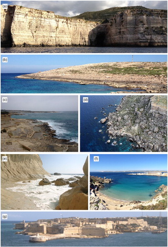
While plunging cliffs and sloping coasts are typical of the resistant Lower and Upper Coralline Limestone formations, shore platforms and cliffs have been shaped on the relatively soft Globigerina Limestone Formation. Screes are observed only in the northern and north-western sectors, where landslides are dominant. Pocket beaches are commonly found along the main bays of the northern sector.
4.2. The geomorphological map
4.2.1. Structural elements and landforms
The geomorphologcal landscape of Malta is strongly influenced by the structural setting of the area (CitationPaskoff & Sanlaville, 1978). The WSW-ENE-oriented horst-graben system, which has developed in the northern and the western sectors of Malta, controls the location of the lowlands (grabens) and headlands (horsts). The main discontinuity is the Great Faults system, which crosses the island from west to east. The Great Faults system starts on the western coast, at Fomm ir-Rih Bay, where the throw is up to 100 m ((a)) and runs through the island reaching the eastern coast, at Madliena ((b)), albeit at relatively lower elevations due to its NNE tilting.
Figure 3. Tectonic landforms: (a) Great Fault plane at Fomm Ir-Rih Bay in the western coast; (b) Great Fault plane at Bahar ic-Caghaq in the eastern coast; (c) Maghlaq fault plane at Ghar Lapsi in the western coast.
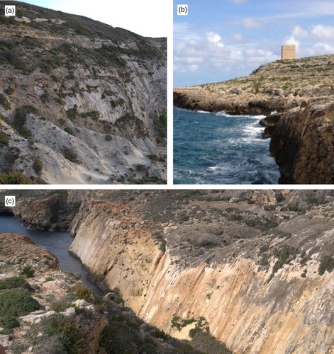
The second system, NW-SE oriented, is related to the Pantelleria Rift and can be recognized in the south-western coast, at Ghar Lapsi, where the Maghlaq Fault occurs ((c)). The fault plane outcrops for more than 2 km along the coastline with a maximum throw of 210 m (CitationBonson, Childs, Walsh, Shopfer, & Carboni, 2007).
4.2.2. Coastal landforms and deposits
The western and south-western coasts generally consist of either Lower or Upper Coralline Limestone and are dominated by plunging cliffs up to 70 m-high. In contrast, the low resistant Globigerina Limestone Formation (mean lowering rates up to 9.16 mm/yr; CitationMicallef & Williams, 2009), which is predominantly along the eastern and south-eastern coasts, favoured the development of extended shore platforms.
Pocket beaches are rare and mainly occur on the northern part of Malta and are occupied by sandy deposits. Marine gorges mainly occur in the western side of Malta, commonly associated with steep discontinuities enlarged by marine processes ((a)). The coastal scenery is characterized by many stacks, arches and sea caves ((b)–4(e)), mainly along the western coast.
Figure 4. Coastal features: (a) marine gorge at Ras Ir-Raheb; (b) stack at Delimara; (c) arch at the entrance of Blue Grotto; (d) marine cave at Ras Ir-Raheb cut in Lower Coralline Limestones; (e) marine cave at Ras Il-Pellegrin cut in Globigerina Limestones; (f) present day tidal notch at Dingli Cliff.
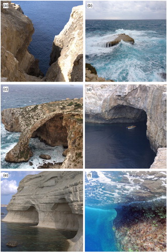
A well-carved tidal notch was surveyed ((f)) at the mean sea level, as previously observed by CitationFurlani et al. (2013).
4.2.2.1. Storm-wave/tsunami deposits
In various parts of the low-lying coasts of the eastern and north-eastern sector of Malta, imbricated boulder deposits can be noticed, ranging from a few decimetres to metres in size (CitationFurlani, Biolchi, Devoto, Saliba, & Scicchitano, 2011; CitationMottershead, Bray, Soar, & Farres, 2014, (a)). The occurrence of encrusted marine shells and bioforms on the boulders proves their marine origin. The deposit located between Armier Bay and Ahrax Point ((b)) has been studied in detail by CitationFurlani et al. (2011) and CitationBiolchi et al. (2013). Radiocarbon datings were performed on three samples of Serpulids (Serpulid polychaetes) ((d)), as shown in , and suggest a combined action of storm and tsunami waves.
Figure 5. (a) Location of the boulder deposits; (b, c) the boulders between Armier Bay and Ahrax Point; (d) Serpulids.
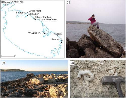
Table 1. Size of the boulders and 14C AMS datings of serpulids performed by the CeDaD Laboratory (Centro di Datazione e Diagnosica) of the University of Salento, Brindisi, Itay; the samples were calibrated using the program Calib 5 (Stuiver, Reimer, & Reimer, Citation2005).
A comparison between dates reported in , the tsunami catalogue (CitationTinti, Maramai, & Graziani, 2004) and the historical Maltese chronicles (CitationGalea, 2007) indicates that the deposition of the boulder AB2 could be related to the 1693 earthquake, which was recorded along the eastern coast of Sicily and on the island of Malta (CitationScicchitano, Monaco, & Tortorici, 2007). The boulder AB3 could be related to the 1169 earthquake, while the boulder AB1 is likely to be related to a storm event in recent times (CitationBiolchi et al., 2013).
4.2.4. Fluvial landforms and deposits
The dense joint system and karstification of limestone prevent the development of a permanent superficial drainage pattern on the limestone plateaus (CitationDevoto et al., 2012) and surface running water is scarce because of the morphoclimatic and lithological conditions. Ancient fluvial remodelling is identified by a series of erosion features, such as small valleys and fluvial scarps. At present, heterometric deposits, composed mainly of sands and silts, are moved by ephemeral streams from plateaus.
Seepage water percolating through the limestone plateaus and rainfall are conveyed along incised channels, forming gullies in the marly and clayey slopes.
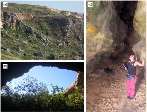
4.2.5. Karst landforms
Karst features are well developed on the limestone plateaus (CitationSaliba, 2008). Sinkholes have been defined according to their diameter: less than or greater than 100 m. All the surveyed sinkholes are characterized by a flat bottom and their genesis is usually caused by the collapse of cave roofs (CitationSoldati, Tonelli, & Galve, 2013; (a) and 6(b)). However, large coastal caves are rare and poorly developed ((c)); therefore not all circular bays may be attributed to a collapsed sinkhole origin. Along the south-eastern coast, specifically at Xrobb l-Ghagin, two large rounded bays (Hofret il-Kbira and Hofret iz-Zghira) can be observed. CitationSoldati et al. (2013) suggest that their evolution is mostly linked to differential erosion caused by geological structure rather than sinkhole collapse.
Figure 6. Karst features: (a) sinkhole at Ghadira Bay; (b) sinkhole originated by cave roof collapse in the Marfa Ridge promontory; (c) cave developed on a cliff located in the south-western coast.
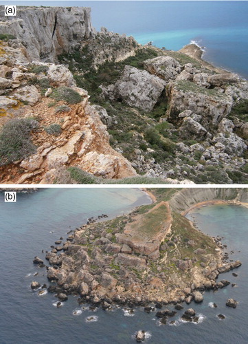
4.2.6. Gravity-induced landforms and deposits
Landslides are widespread in the northern sector of Malta (CitationDevoto et al., 2013). The geological setting favours the development of extensive block slides and rock spreads ((a) and 7(b)). Rock spreads affect limestone plateaus favoured by vertical discontinuities, whose persistence may exceed 200 m in length (CitationDevoto, 2013). The lateral extension of rock masses often evolves into block slides and may be accompanied by rockfalls and rock topples. Block sliding can be favoured by moistening of the clay slopes, which are also affected by earth flows and earth slides (CitationDykes, 2002).
Figure 7. Rock spreads and block slides: (a) Marfa Ridge; (b) Il-Qarraba (Courtesy of Ten. Col. M. Marchetti).
Based on Cruden and Varnes’ classification (Citation1996), CitationDevoto et al. (2012) produced a detailed inventory of landslides as part of recently established research including long-term monitoring of rock spreads and block slides (CitationMagri et al., 2008; CitationMantovani et al., 2013; CitationSoldati, Maquaire, Zezere, Piacentini, & Lissak, 2011).
Considering the survey's purpose and the medium-scale map output, all landslide deposits were generally mapped as ‘area affected by landslides’.
4.2.7. Anthropogenic landforms
The eastern and southern sectors of Malta are intensely urbanized. With a history of human occupancy (by Phoenicians, Carthagians, Romans, Arabs, Normans, knights of St. John, French, British) of approximately 7000 years, the island of Malta has an intense and diverse use of coastal land use ranging from towns, villages, recreational areas, harbours, military land use and industrial and servicing areas. These land uses have all been grouped and mapped as ‘built-up area’. Quarries, dumping sites and salt-pans have been plotted with appropriate symbols.
5. Conclusions
This paper and related maps provide the classification and spatial distribution of the coastal landforms of the island of Malta. Particular attention has been devoted to the representation of coastal features, which are strongly influenced by the tectonic setting and the lithological characteristics of outcropping rocks.
The output is a 1:30,000 geomorphological map of the Maltese coastal sector. In addition, a 1:100,000 map of the coastal geomorphotypes, which displays the geometric and topographic features of the coast, including the location of large boulder deposits occurring in the north-eastern and eastern coasts of Malta are provided.
Moreover, this paper provides the preliminary results of the analyses carried out on a large boulder deposit in the NE coast of Malta, where a combined action of tsunami and extreme storm waves can be hypothesized as responsible for the detachment, movement and deposition of large rocky boulders.
Software
The map was produced using Esri ArcGIS and Adobe IllustratorCS6 was used for preparing the layout.
MAP OF THE COASTAL LANDFORMS OF MALTA 1:30.000
Download PDF (23.7 MB)Acknowledgements
The field activities were partially funded by a project of the EUR-OPA Major Hazard Agreement of the Council of Europe (Responsible: M. Soldati). The Authors are grateful to ‘AquaBioTech Group’ for providing access to high-resolution LiDAR data, to Franco Cucchi and Chiara Boccali of the University of Trieste and to Mariacristina Prampolini of the University of Modena and Reggio Emilia.
References
- Alexander, D. (1988). A review of the physical geography of Malta and its significance for tectonic geomorphology. Quaternary Science Review, 7, 41–53.
- Baldassini, N., Mazzei, R., Foresi, L. M., Riforgiato, F., & Salvatorini, G. (2013). Calcareous plankton bio-chronostartigraphy of the Maltese Lower Globigerina Limestone member. Acta Geologica Polonica, 63(1), 105–135.
- Biolchi, S. (2013). Morphoneotectonic investigations in coastal areas: The case studies of the NE Adriatic Sea and the Maltese Island (PhD thesis). University of Modena and Reggio Emilia, Modena.
- Biolchi, S., Furlani, S., Antonioli, F., Schicchitano, G., Cucchi, F., Drap, P., … Saliba, D. (2013, August 26–31). Large boulders accumulation along the NE Maltese coast: Stormwaves or tsunami event? 8th IAG International Conference on Geomorphology, Paris (France).
- Bonson, C. G., Childs, C., Walsh, J. J., Shopfer, M. P. J., & Carboni, V. (2007). Geometric and kinematic controls on the internal structure of a large normal fault in massive limestones: The Maghlaq Fault, Malta. Journal of Structural Geology, 29, 336–354.
- Cruden, D. M., & Varnes, D. J. (1996). Landslide types and processes. In A. K. Turner & R. L. Schuster (Eds.), Landslides, investigation and mitigation ( Vol. Special Report 247, pp. 36–75). Washington, DC: National Academy Press.
- Dart, C. J., Bosence, D. W. J., & Mcclay, K. R. (1993). Stratigraphy and structure of the Maltese Graben system. Journal of the Geological Society, 150, 1153–1166.
- Devoto, S. (2013). Cartografia, monitoraggio e modellizzazione di frane lungo la costa nord-occidentale dell'isola di Malta (PhD thesis). University of Modena and Reggio Emilia, Modena.
- Devoto, S., Biolchi, S., Bruschi, V. M., Furlani, S., Mantovani, M., Piacentini, D., … Soldati, M. (2012). Geomorphological map of the NW coast of the Island of Malta (Mediterranean Sea). Journal of Maps, 8(1), 33–40.
- Devoto, S., Biolchi, S., Bruschi, V. M., González-Díez, A., Mantovani, M., Pasuto, A., … Soldati, M. (2013). Landslides along the north-west coast of the Island of Malta. In C. Margottini, P. Canuti, & K. Sassa (Eds.), Landslide science and practice, volume 1: Landslide inventory and susceptibility and Hazard zoning (pp. 57–64). Heidelberg: Springer.
- Dykes, A. P. (2002). Mass movements and conservations management in Malta. Journal of Environmental Management, 66, 77–89.
- Finetti, I. R. (1984). Geophysical study of the sicily channel rift zone. Bollettino di Geofisica Teorica ed Applicata, 26, 3–28.
- Furlani, S., Antonioli, F., Biolchi, S., Gambin, T., Gauci, R., Lo Presti, V., … Sulli, A. (2013). Holocene sea level change in Malta. Quaternary International, 288, 146–157.
- Furlani, S., Biolchi, S., Devoto, S., Saliba, D., & Scicchitano, G. (2011). Large boulder along the NE Maltese coast: tsunami or storm wave deposits? Journal of Coastal Research, 61, 470–470.
- Furlani, S., Pappalardo, M., Gomez-Pujol, L., & Chelli, A. (2014). The rock coast of the mediterranean and black seas. In D. M. Kennedy, W. J. Stephenson, & L. Naylor (Eds.), Rock coast geomorphology: A global synthesis (Vol. 40, pp. 89–122). Avon: Geological Society Memoirs, published by Geological Society Publishing House.
- Galea, P. (2007). Seismic history of the Maltese Islands and considerations on seismic risk. Annals of Geophysics, 50(6), 725–740.
- Giannelli, L., & Salvatorini, G. (1972). I Foraminiferi planctonici dei sedimenti terziari dell'Arcipelago Maltese. Biostratigrafia del ‘Globigerina Limestone’. I. Atti della Società Toscana di Scienze Naturali, Memorie Serie A, 79, 49–74.
- Gruppo di Lavoro per la Cartografia Geomorfologica. (1994). Carta geomorfologica d'Italia 1:50.000 – Guida al rilevamento. Quaderni SGN, serie III, 4, 42. Retrieved November 4, 2012, from http://www.isprambiente.gov.it/contentfiles/00004000/4048-quad4.zip
- Magri, O. (2006). A geological and Geomorphological review of the Maltese Islands with special reference to the coastal zone. Territoris, 6, 7–26.
- Magri, O., Mantovani, M., Pasuto, A., & Soldati, M. (2008). Geomorphological investigation and monitoring of lateral spreading along the north-west coast of Malta. Geografia Fisica e Dinamica Quaternaria, 31(2), 171–180.
- Mantovani, M., Devoto, S., Forte, E., Mocnik, A., Pasuto, A., Piacentini, D., & Soldati, M. (2013). A multidisciplinary approach for rock spreading and block sliding investigation in the north-western coast of Malta. Landslides, 10, 611–622.
- Micallef, A., & Williams, A. T. (2009). Shore platform denudation measurements along the Maltese coastline. Journ. of Coastal Research, Special Issue, 56, 737–741.
- Mottershead, D., Bray, M., Soar, P., & Farres, P. J. (2014). Extreme waves events in the central Mediterranean: Geomorphic evidence of tsunami on the Maltese Islands. Zeitschrift fűr Geomorphologie, 58, 385–411.
- Oil Exploration Directorate. (1993). Geological map of the Maltese Islands. Valletta: Office of the Prime Minister.
- Paskoff, R., & Sanlaville, P. (1978). Observations géomorphologiques sur le cotes de l'archipel maltais. Zeitschrift fűr Geomorphologie, 22, 310–328.
- Pedley, M. (2011). The Calabrian Stage, Pleistocene highstand in Malta: A new marker for unravelling the Late Neogene and Quaternary history of the islands. Journal of the Geological Society, 168(4), 913–926.
- Pedley, H. M., Clarke, M. H., & Galea, P. (2002). Limestone isles in a crystal sea, the geology of the Maltese Islands. Malta: PEG Ltd.
- Pedley, H. M., House, M. R., & Waugh, B. (1976). The geology of Malta and Gozo. Proceedings of the Geologists' Association, 87, 325–341.
- Reuther, C. D., & Eisbacher, G. H. (1985). Pantelleria Rift crustal extension in a convergent intraplate setting. Geologische Rundschau, 74(3), 585–597.
- Said, G., & Schembri, J. (2010). Malta. In E. C. F. Bird (Ed.), Encyclopedia of the world's coastal landforms – Volume 1 (pp. 751–759). Dordrecht: Springer Science+Business Media B.V.
- Saliba, D. (2008). Cave formations and processes in Malta (BA thesis). University of Malta, Msida.
- Scicchitano, G., Monaco, C., & Tortorici, L. (2007). Large boulder deposits by tsunami waves along the Ionian coast of south-eastern Sicily (Italy). Marine Geology, 238, 75–91.
- Soldati, M., Maquaire, O., Zezere, J. L., Piacentini, D., & Lissak, C. (2011). Coastline at risk: Methods for multi-Hazard assessment. Journal of Coastal Research, 61, 335–339.
- Soldati, M., Tonelli, C., & Galve, J. P. (2013). Geomorphological evolution of palaeosinkhole features in the Maltese Archipelago (Mediterranean Sea). Geografia Fisica e Dinamica Quaternaria, 36, 189–198.
- Stuiver, M., Reimer, P. J., & Reimer, R. (2005). Calib radiocarbon calibration, execute version 5.0.2 html. Retrieved December 1, 2012 from http://calib.qub.ac.uk/calib/
- Sunamura, T. (1992). Geomorphology of Rocky coasts (Vol. 302). New York: Wiley and Sons.
- Tinti, S., Maramai, A., & Graziani, L. (2004). The new catalogue of Italian tsunamis. Nat. Hazards, 33, 439–465.
- Trenchmann, C. T. (1938). Quaternary conditions in Malta. Geological Magazine, 75(1), 1–26.
- Trenhaile, A. S. (1987). The geomorphology of rocky coasts. Oxford: Clarendon Press.