
Abstract
New detailed maps of two key areas of the Southalpine basement unravel the superposition of pre-Alpine deformation stages associated with different metamorphic imprints, and distinguish Alpine thrust and fold structures involving basement and Permian-Mesozoic sedimentary cover. Basement rocks consist of metasediments (micaschists, quartzites and paragneisses) and metagranitoids and cover rocks comprise Permian volcanics and sediments. The boundaries between two tectono-metamorphic units have been distinguished at the map scale, thanks to the integrated use of structural and petrological analyses, on the basis of foliation trajectories supported by metamorphic assemblages. Two different pre-Alpine metamorphic evolutions characterise a basement portion that seemingly appears as a monotonous sequence dominantly affected by a greenschist-facies imprint. The volcano-sedimentary sequence of Permian age has been used as the time marker that separates Alpine from pre-Alpine superposed structures; Alpine deformation consists of two superposed groups of structures, the first of which is locally associated with a very low-grade metamorphic imprint and related at the regional scale to a south-verging thrust system.
1. Introduction
The aim of field mapping of metamorphic basement of orogenic belts is the individuation of tectonic units that requires, in addition to the classical structural and lithostratigraphic tools useful to unravel, for example, basement–cover relationships, to decipher the deformation–metamorphism relationships at the regional scale. Such an investigation is useful to discriminate basement portions that underwent different structural and metamorphic histories and therefore representing separated tectono-metamorphic units (= TMUs; e.g. CitationSpalla, Siletto, Di Paola, & Gosso, 2000; CitationZucali, Spalla, & Gosso, 2002). The evolution of analytical tools for correlation methods in orogenic belts (CitationHobbs, Means, & Williams, 1976; CitationLardeaux & Spalla, 1990; CitationPasschier, Myers, & Kröner, 1990; CitationRoda & Zucali 2008; CitationSpalla, Zucali, Di Paola, & Gosso, 2005; CitationTurner & Weiss, 1963; CitationWilliams, 1985) highlights that the more effective approach to infer an accurate tectonic and metamorphic evolution in polydeformed terrains is the contemporaneous regional correlation of meso- and micro-structures and the associated metamorphic phase assemblages. Detailed structural mapping that validates the sequence of superposed structural and metamorphic imprints at the regional scale must support an accurate correlation. This integrated petrological and structural analysis generates high-precision Pressure–Temperature–relative time of deformation evolutions (P–T–d–t paths), that, in the central part of the Southalpine domain, highlighted adjacent portions of the pre-Alpine basement, recording structural and metamorphic imprints related to contrasted and diachronous tectonic histories (CitationSpalla & Gosso, 1999; CitationSpalla et al., 2014). These contrasted records have been inferred within single lithostratigraphic units, making necessary the distinction of tectonic units on the basis of their structural and metamorphic memory (TMUs). In spite of the accurate definition of the P–T–d–t histories, boundaries between TMUs are only locally precisely mapped and the two maps presented here regard a region where contrasted P–T–d–t evolution has been inferred. The integrated use of petrographic and multi-scale structural analysis can reveal the geometry of the tectonic boundary and shed light on the structural level of tectonic units coupling. The two maps presented in this contribution were made in key areas of the easternmost sector of the Orobic Alps, where different P–T–d–t evolutions have been inferred in rocks attributed to the same lithostratigraphic unit (CitationSpalla & Gosso, 1999; CitationSpalla, Carminati, Ceriani, Oliva, & Battaglia, 1999). Here, the occurrence of Permian cover rocks allows the separation of structures affecting exclusively the pre-Permian basement, and therefore developed during the pre-Alpine evolution, from structures affecting both the basement and the sedimentary cover, and therefore of Alpine age (CitationAlbini et al., 1994; CitationGosso et al., 2012; CitationSpalla et al., 1999).
2. Geological setting
The two maps have been realised in the Eastern end of the Orobic Alps, representing the central portion of the Southalpine Domain () that is separated from the axial portion of the Alpine belt (Penninic and Austroalpine domain) by the Periadric Lineament. The Variscan metamorphic basement mainly constitutes its northern portion, whereas Upper Palaeozoic to Tertiary cover dominates the southern part.
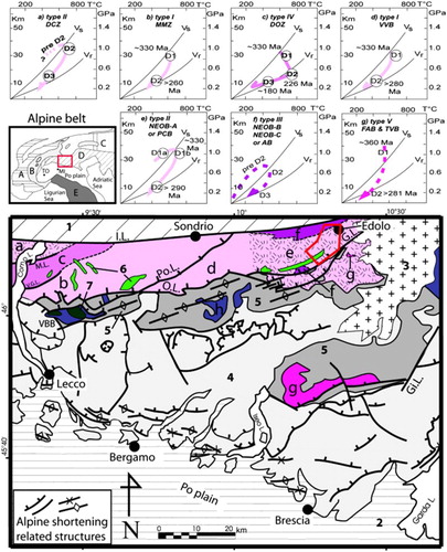
Figure 1. Tectonic map of the Central Southern Alps with different tectonic and metamorphic evolutions recorded in the Variscan basement (redrawn after CitationGosso et al., 2012; CitationSpalla & Gosso 1999; CitationSpalla et al., 2009; CitationZanoni et al., 2010). Legend: 1 = Penninic and Austroalpine domain, and Bergell intrusive stock; 2 = Po Plain; 3 = Adamello pluton; 4 = post-Permian sedimentary cover; 5 = Permian–Upper Carboniferous sediments (a) Western Orobic Basin; (b) Eastern Orobic Basin; (c) Val Trompia Basin); 6 = Variscan metagranitoids; 7 = Permian–Carboniferous granitoids. Pink/violet colours indicate the metamorphic basement, greens indicate prealpine intrusives and greys, the covers. Different tones of pink colour indicate different tectonometamorphic units in the Southalpine basement as distinguished on the basis of their PT-paths (see hereafter); violet indicates portions of undifferentiated metamorphic basement. Main tectonic lines: P.L., Periadric Lineament; G.L., Gallinera Line; M.L., Musso Line; V.G.L., Lugano–Val Grande Line; Po.L., Porcile Line; O.L., Orobic Line; VBB – Val Biandino Basement; Gi.L., Giudicarie Line. P–T paths related to different TMUs: (a) DCZ = Domaso Cortafò Zone; (b) MMZ = Monte Muggio Zone; (c) DOZ = Dervio Olgiasca Zone; (d) VVB = Val Vedello basement; (e) NEOB-A or PCB = North East Orobic basement – type A or Passo Cavalcafiche basement; (f) NEOB-B, NEOB-C or AB = North East Orobic basement – type B, North East Orobic basement – type C or Aprica Basement; (g) FAB and TVB = Forno d'Allione and Tre Valli Bresciane basement; (h) undifferentiated metamorphic basement. Qualitative or semi-quantitative P–T paths are marked by dashed line and quantitative P–T paths are marked by solid line; Vs and Vr denote stable and relaxed geotherms, respectively (CitationEngland & Thompson, 1984). Alpine belt structural domains: A = Helvetic; B = Penninic; C = Austroalpine; D = Southalpine.
The Southern Alps architecture results from crustal thickening, involving a shallow portion of the Variscan metamorphic basement and the Palaeozoic to Tertiary volcano-sedimentary sequences, developed during Alpine convergence (CitationBrack, 1983; CitationCassinis et al., 1986; CitationCastellarin, 1979; CitationCastellarin et al., 1992; CitationDoglioni & Bosellini, 1987; CitationGaetani & Jadoul, 1979; CitationLaubscher, 1985; CitationSchönborn, 1992) from Late Cretaceous to Tertiary and that generated a thick-skin south-verging thrust system (Figure A in the Main Map). The main ENE-WSW tectonic boundaries are cut by the Tertiary Adamello intrusion, dated between 42 and 35 Ma (CitationCallegari & Brack, 2002; CitationDel Moro, Pardini, Quercioli, Villa, & Callegari, 1983; CitationMayer et al., 2003; CitationSchaltegger et al., 2009; CitationSchoene et al., 2012), and by the associated dyke swarms (CitationBrack, 1981, Citation1983; CitationCassinis & Castellarin, 1988; CitationD'Adda et al., 2011; CitationFantoni et al., 1999). Alpine structures have been recently interpreted as the effect of a convergent lithosphere dynamics inducing gravitational effects at the shallowest structural level (CitationCarminati & Siletto, 1997; CitationCarminati, Siletto, & Battaglia, 1997 and refs. therein).
The detailed structural analysis at the boundary between Permian cover and Variscan metamorphic basement in the central Orobic Alps allowed the distinction of Alpine and pre-Alpine structures and the individuation of N50 striking extensional faults, bounding Permian basins (CitationCadel, Cosi, Pennacchioni, & Spalla, 1996; CitationCassinis et al., 1986; CitationMilano, Pennacchioni, & Spalla, 1988).
The Pre-Alpine structural evolution, consisting of at least two superposed deformation stages, is accompanied by polyphase metamorphic histories mainly recorded during a retrograde P–T evolution (CitationBertotti, Siletto, & Spalla, 1993; CitationDiella, Spalla, & Tunesi, 1992; CitationGosso, Siletto, & Spalla, 1997; CitationGosso et al., 2012; CitationMilano et al., 1988; CitationSpalla & Gosso, 1999; CitationSpalla et al., 1999; CitationSpalla, Zanoni, Gosso, & Zucali, 2009; CitationZanoni, Spalla, & Gosso, 2010). Structural and metamorphic evolutions inferred in different portions of Southalpine Orobic basement allow the individuation of five different types () of TMUs (CitationSpalla et al., 2014 and refs. therein), but tectonic contacts are accurately traced only locally. Type I consists of metamorphic rocks displaying an evolution from amphibolite- to greenschist-facies conditions, indicating the exhumation of deep-seated continental crust from nearly 30 km depth; type II metamorphic rocks preserve part of a P–T prograde evolution pre-dating an amphibolite-facies, and successively a greenschist-facies imprint similar to those characterising type I; type III consists of metapelites transformed exclusively under greenschist-facies conditions, in which black phyllites containing Silurian-Ordovician microfossils have been described (CitationGansser & Pantic, 1988); type IV includes metamorphic rocks characterised by the transition from amphibolite- to Permian-Mesozoic amphibolite/granulite-facies conditions of low pressure, followed by a isobaric T-decrease up to greenschist-facies conditions; finally, type V consists of continental crust that escaped the Barrovian metamorphic imprint related to the Variscan collision and it is characterised by a sequence of two syn-metamorphic deformation phases developed under epidote–amphibolite and greenschist-facies conditions (CitationSpalla et al., 2009 and refs. therein).
Such contrasted tectonic and metamorphic histories account for a complex pre-Alpine geodynamic evolution (CitationDiella et al., 1992; CitationSiletto, Spalla, Tunesi, Lardeaux, & Colombo, 1993; CitationZanoni et al., 2010) responsible for: (i) the tectonic thickening consequent to the Variscan subduction and collision; (ii) late orogenic extension; and (iii) lithospheric continental thinning postdating the Variscan gravitational evolution and heralding the Jurassic oceanisation (CitationMarotta, Spalla & Gosso 2009).
3. Mapping technique and software
The maps represent the lithological associations and the regional grid of overprinting foliations, associated with the indications of the metamorphic environment in which they developed. The chosen representation allows the visualisation of different episodes of the thermomechanical evolution through the use of different symbols and colours. Following methods used in mineral prospections (CitationJohnson & Duncan, 1992) and already used in metamorphic terrains in the Alps (CitationBaletti, Zanoni, Spalla, & Gosso 2012; CitationDelleani, Spalla, Castelli, & Gosso, 2013; CitationDi Paola & Spalla, 2004; CitationSpalla et al., 2000; CitationZucali et al., 2002), it is therefore possible to recognise tectonic contacts, even when they are partially obliterated, sutured and polydeformed, individuating also the structural level at which coupling between tectonic units took place, thanks to the information on the metamorphic environment of fabrics development.
In summary, such kind of mapping represents an integrated report of the field and laboratory analytical work carried out in order to reconstruct the relationships between finite deformation field, metamorphic evolution and different lithological settings. The relative chronology of overprinting planar fabrics is shown on the maps by the number of dots along trajectory traces for Variscan structures; D3 Alpine trajectories are represented by solid black lines. Mineral assemblages related to successive fabrics in each rock type are added in the legend, and represent the basic elements used to identify the metamorphic environment in which the successive fabric groups developed (indicated by differently coloured trajectories). In this way, information regarding the relative chronology of structural imprints and the metamorphic environment in which they developed is synthesised and spatially located.
The geographical location and a tectonic map (with a related legend) introduce the main maps at a 1:10,000 scale with a related legend. The projection coordinate system is UTM ED50. The map presents a synthesis of the whole data set on a redrawn original topographic base (the Technical Regional Topography, provided by the Lombardia Regional Administration). The geological cross-sections are shown in two perpendicular sets of panels to give, together with a block-diagram, a 3D visualisation. Stereographic projections summarise the structural data represented on the maps. Structural data analysis was performed using the computer software stereonet (CitationCardozo & Allmendinger, 2013). Final map layout and geological cross-sections have been drawn using the commercial computer software Adobe Illustrator.
4. Structural and petrographic data
Multiscale structural analysis, performed since the end of 1980s in central Southern Alps, allowed the separation of Alpine tectonic history from the pre-Alpine, which affected exclusively the metamorphic basement rocks. In a recent synthesis of the field and laboratory data, CitationGosso et al. (2012) individuated three TMUs at the eastern end of the Orobic Alps, on the basis of their thermal and deformational histories (Figure A in the Main Map). The two maps presented in this contribution (Map A and Map B in the Main Map) have been carried out in a region where two TMUs crop out, namely Passo Cavalcafiche and Aprica TMU, corresponding to NEOB-A and NEOB-B/C described by CitationSpalla et al. (2009), ().
4.1. Lithotypes
Basement rocks belonging to the two tectonic units were grouped in the ‘Edolo Micaschists’ ‘informal formation’ of the ancient literature (CitationSalomon, 1901), which consists of metapelites, with lenses of quartzites and minor marbles. The only distinguishing lithological character of Passo Cavalcafiche TMU is the occurrence of widespread metagranitoids ( and ) and minor amphibolites ((a)), lacking in the Aprica TMU ((b) and 3(c)). Layers of grey-pink quartzites, with thin layers of white mica and chlorite and biotite and garnet relics, with at places gradational transition to the enclosing rocks, and fine-grained plagioclase-white mica and quartz paragneisses ((d)) are interlayered in the generally chlorite-rich micaschists, containing diffused relics of biotite and only locally of garnet, which can occur concentrated in thin layers ((a)–(c)). Metagranitoids ((d)) are mainly chlorite and white mica-bearing flaser gneisses, locally with a discrete lineation marked by elongated aggregates of quartz and feldspars. Relics of red-brown biotite and of minor garnet are still saved by diffused chlorite growth ((e) and 3(f)). Igneous textures and mafic inclusions are only locally preserved. Finally, minor white mica- and chlorite-bearing amphibolite with relics of garnet, rutile and titanite occurs in up to metric lenses and bands.
Figure 2. Meso- and outcrop-scale structures observed in the area, foliations are distinguished by different number of dots: S1 – one dot; S2 – two dots; S3 – three dots. (a) Interference figures between D1 and D2 and later D3 folding in micaschists, Passo Cavalcafiche TMU. Camera cap diameter is 52 mm. (b) Quartzite layer transposed in the micaschists by S2 foliation, the hinge preserving S1 foliation. D3 chevron folds affect S2 in the lower part of the figure, Passo Cavalcafiche TMU. Coin diameter is 2 cm. (c) S1, S2 and D3 structures preserved at outcrop scale in a quartzite-micaschist multilayer, north of Passo Salina, Passo Cavalcafiche TMU. Hammer head is 10 cm horizontally. (d) Klippen of Permian volcanics foliated by S3, in contact with S3 foliation (band between dotted lines in figure), through a cataclastic band with gneiss affected by S2 sub-vertical foliation, near Palone del Torsolazzo, Passo Cavalcafiche TMU. Person at the lower left corner is 1.70 m tall. (e) S3 foliation in sediments. Camera cap diameter is 52 mm.
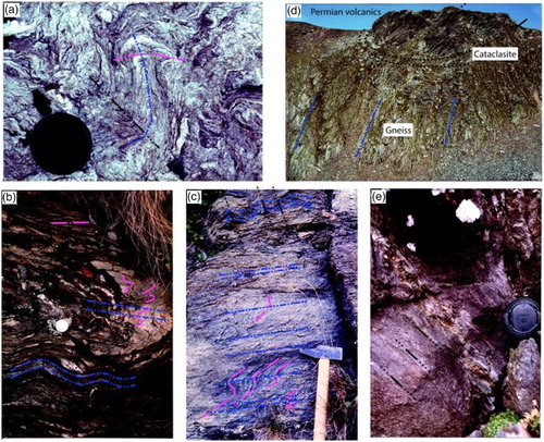
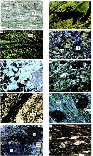
Figure 3. Microstructures and mineral assemblages characterising different lithologies. Aprica TMU: (a) Amphibolite – S2 foliation defined by amphibole (amp), plagioclase (pl), biotite (bt) and opaques (op), long side of the image is 1.5 cm. Aprica TMU; (b) Foliated phyllonite, S2 is defined by fine-grained mica (wm), long side of the image is 5 mm; (c) D2 crenulation cleavage in fine-grained garnet (g) bearing metapelite. Note relic D1 in some of the lithons, long side of the image is 7 mm. Passo Cavalcafiche TMU; (d) Paragneiss with porphyroclasts of plagioclase and white mica transversal to the S2 foliation defined by mica-rich layers, in which D3 kink-folds are recognisable (upper left part of the image), long side of the image is 15 mm; (e) Ortogneiss – Biotite (partially substituted by chlorite) and garnet in S2 foliation defined by the alignment of quartz-feldspar (q + fs) rich layers, long side of the image is 15 mm; (f) Retrogressed gneiss – S2 foliation with garnet porphyroblasts enveloped by chlorite (chl) and quartz-albite (q + ab) lithons parallel to the foliation. Biotite is here completely substituted by chlorite, long side of the image is 15 mm; (g) Zoned tourmaline (green mineral) rich layers folded by D3 folds, long side of the image is 10 mm; (h) Micaschist – garnets enveloped by S2 foliation defined by alternating mica-rich and quartz-feldspar rich millimetre layers, and by the preferred orientation of white mica, long side of the image is 20 mm; (i) Gneiss – Feldspar (fs) and garnet porphyroblasts with inclusions of white mica. In the upper left corner, S2 defined by white mica iso-orientation is kinked by F3 folds. Garnet is partially substituted by chlorite along fractures, long side of the image is 15 mm; (j) Mylonitic mica-rich layers in cataclastic bands with quartz (q) porphyroclasts and asymmetric pressure shadows; long side of the image is 6 mm.
Permian cover rocks occur as small tectonic slices pinched in basement rocks, finely foliated and consisting of volcaniclastic deposits, conglomerates, sandstones and siltstones ((d) and (2e)) probably belonging to Verrucano Lombardo and Collio Formations (CitationGosso et al., 2012). Sandstones and siltones are very deformed and consist of a fine-grained sericitic matrix with a few quartz- feldspar and albite clasts. Some quartz clasts have gulf structures, indicating a volcaniclastic origin. Conglomerates have angular quartz and basement rocks clasts. Tourmalinites have been detected as levels in the sedimentary cover (Palone del Torsolazzo on map A) or as deformed lenses, crosscut by quartz veins, at the boundary between micaschists and metagranitoids (Val Moranda, Monte Palone on map A, (g)). Different types of early and late dykes occur: the first type is coarse-grained, characterised by plagioclase, biotite, pyroxene, amphibole and opaques. Mafic minerals are partially to completely substituted by chlorite, and minor carbonates are observed at places. These dykes are sometimes affected by D3 foliation. The second group of fine-grained porphyric dykes contains plagioclase and amphibole, crosscuts the Alpine structures and may show chilled margins and flow textures, normally with metric thickness, and intrudes both the basement and cover rocks.
5. Structures
In the following, the results of multiscale structural analysis are separately described for each inferred deformation stage: they were obtained by a synthesis of fieldwork results and microstructural analyses performed on samples representing the same relative age groups of structures in different rock types. Deformation–metamorphism relationships for the pre-Alpine syn-metamorphic structures in metapelites are reported in ; orientations of all described successive groups of structures are shown in two synoptic tables on Schmidt projections, lower hemisphere, associated with the two maps (A and B) in the Main Map.
Table 1. Sequence of assemblages in the two tectonometamorphic units (rows) supporting the superposed fabrics (columns).
5.1. D1 and pre-D2
In the Passo Cavalcafiche TMU, D1 structures are mainly small, rootles, isoclinal folds preserved in the less deformed domains of S2, especially where micaschists have abundant quartz layers ((b) and 2(c)). Polyphase relict foliations in S2 microlithons with chloritoid-bearing or staurolite-bearing assemblages have been described in adjacent areas (CitationSpalla et al., 1999), as synchronous with D1a and D1b, respectively. Staurolite relics detected in this area only at Piz Tri (North of Lago Lungo in map A) occur as isolated porphyroclasts, due to a more pervasive greenschist facies re-equilibration related to D2, making difficult the attribution to a specific ancient fabric, and therefore they are interpreted simply as pre-D2 remnants. S1 is defined by the shape preferred orientation (SPO) of biotite and white mica and garnet is mainly preserved in the microlithons. Garnet and biotite may occur in contact with rational boundaries, suggesting textural equilibrium during D1 ((e)). Well-preserved garnets have an internal foliation marked by opaque and quartz trails ((h)). Rutile, opaque minerals, plagioclase, apatite and rare epidote and tourmaline occur in quartz- feldspar-rich domains of S1 together with garnet, biotite and white mica. Where lithological markers such as metagranitoid layers are found, D1 folds are well preserved and recognisable at the meso- and mega-scales, with hinges that reach hundreds of metres in metagranitoids (E of M. Faeto, map B and block diagram). In metagranitoids, the S1 is marked by biotite and white mica SPO, garnet porphyroblasts predate S2 and relict K-feldspar porphyroclasts are wrapped by S1 ((i)).
In quartzites of the Aprica TMU D1 folds are well preserved as hundred metre scale structures ((b) and 4(b) in the Main Map) and generally, in micaschists or phyllites, D1 structures consist of small, rootles, isoclinal folds preserved in the less deformed domains of S2. The mineral assemblage associated with S1 is muscovite, plagioclase, quartz, opaque minerals, biotite, chlorite, ± garnet, suggesting greenschist-facies conditions ((b) and 3(c)). In phyllites from this unit, relics of palynomorphs and marine microplankton of Ordovician-Silurian age have been detected (CitationGansser & Pantic, 1988).
5.2. D2
In both TMUs, D2 folds are isoclinal, with thickened hinges and attenuated limbs ((b)). S2, which is mainly defined by SPO of chlorite and white mica, is the most pervasive fabric element at the regional scale and is steeply dipping to the NNW. It consists of a well-differentiated crenulation cleavage often evolved up to a continuous foliation ((a, c, f, g)). Biotite, which is usually aligned along S1, has lobate margins and is overgrown by chlorite and new white mica along the (001) cleavage, where it has been rotated parallel to S2, or replaced by sagenitic chlorite ((e)). Garnet is wrapped by S2 and variably replaced by chlorite ((h) and 3(i)). Biotite and white mica porphyroclasts ((d)) show internal deformation and are partly replaced by chlorite and a second generation of fine-grained white mica along (001). Sphene and albite porphyroclasts including garnet, quartz, white mica, tourmaline and opaque minerals are syn-kinematic with S2. In micaschists, S2 locally becomes mylonitic, and is then enriched in chlorite, graphite and carbonates, giving rise to a black phyllonite. These mylonitic horizons, similar to those described as old folded mylonites by CitationLardelli (1981), are associated with anastomosed mm to cm thick quartz and carbonate veins, widespread in the metapelites of Aprica TMU and abundant at the contact with the Passo Cavalcafiche TMU. In metagranitoids, S2 is marked by chlorite and white mica films, sometimes comprising new green-biotite, alternate to quartz-albite rich domains containing garnet relicts that are partially to totally replaced by chlorite ((i)). In D2 mylonites, a fine-grained aggregate of chlorite and white mica is interlayered with ribbon quartz, and only feldspars and garnet porphyroclasts are locally preserved. Mylonitic bands are concentrated at the boundaries with micaschists where the mylonitic bands together with D1 and D2 superposed rootless folds are responsible for the gradational transition between these two rocks (near Passo Salina and further to the south in map A). Overprinting of D2 on D1 folds ((b)) gives rise to type 3 interference patterns (CitationRamsay, 1967).
5.3. D3
This group of structures are comprehensive of meso- to mega-scale kink bands in metagranitoids (South of Passo Salina) and chevron folds in micaschists and quartzite. The interlimb angle of the kinks is 40°–60° and the axial plane steeply dips towards NNW (with a maximum at 340°/70°–80°). In metapelites and metagranitoids, D3 microtextures are micro chevron folds or crenulations. Chlorite and opaque minerals are concentrated in D3 microfold hinges. Overprint of D3 on previous folds generates types 2 and 3 interference patterns. D3 folds affect Permian cover rocks, exposed in the southernmost sector of map A ((d)), and correspond to the regional southverging Alpine fold and thrust system (CitationAlbini et al., 1994). In the sedimentary rocks, D3 folds are open to isoclinal, with steep axial planes. S3 is a differentiated foliation ((e)), with a few mm- to some cm-spacing, and defined by SPO of opaque minerals, fine-grained carbonates and sheet silicates. Detrital quartz, feldspar and white mica show internal deformation and lobate margins and are re-oriented parallel to S3; elongated pebbles in conglomerates are flattened and aligned parallel to S3, acidic volcanic pebbles being distinctively more flattened than quartz ones. The D3 thrusts are evidenced by up to 300 m wide and up to few km long synforms of sedimentary rocks, locally boudinaged along cataclastic zones (SW portion of Map A, south of Palone del Torsolazzo). Folds are associated with thrusts, and the cover-basement contacts may be either primary or tectonic, being folded and thrust together.
5.4. D4
The last group of structures consists of cataclastic bands and subhorizontal shear planes ranging from 330/30 to 040/30, characterised by top to SE shear sense, both in the basement and in the cover rocks ((j)), and which crenulate the S3 foliation when present. The shear planes are especially evident in the cover rocks. Open folds or gentle waving of pre-existing structures also occurs, and a crenulation cleavage rarely develops in the sedimentary rocks (see also CitationGosso et al., 2012). Folds and shear planes both belong to the D4 structures and could represent a different deformation stage or a late incremental stage of D3.
6. Summary and conclusive remarks
The representation technique used to illustrate results of the integrated structural and petrographic analysis here performed makes very effective the immediate perception of the distribution in space of the deformation history record by means of the superposed grid of foliations and the associated succession of mineral assemblages.
The inferred structural and metamorphic evolutions indicate that four generations of superposed folds affected this portion of Southalpine domain at the easternmost end of the Orobic Alps. The earlier two (D1 and D2) are syn-metamorphic. They affect exclusively the basement rocks and are responsible for the geometry of the lithological boundaries in the Variscan metamorphic basement. The two late groups of structures (D3 and D4), deforming together the Permian cover and the Variscan basement, developed during Alpine convergence, and consist of a grid of thrusts separating the pre-Alpine structural framework into detached slices.
Style of deformation, coherence of fabric orientation and of metamorphic assemblages allow to correlate the greenschist D2 structures of the two mapped TMUs and to relate them, at the regional scale, with the greenschist D2 structures described in surrounding areas (CitationGosso et al., 2012 and refs. therein). D2 structures actually affect also the boundary between Passo Cavalcafiche and Aprica TMUs that during D1 recorded different metamorphic imprints. Relationships between metamorphic assemblages and pre-D2 structures indicate that in Passo Cavalcafiche TMU, D1 developed under amphibolite-facies conditions, following an earlier epidote amphibolite-facies imprint, and that a retrograde Pressure–Temperature (PT) evolution accompanied the transition to the syn-D2 greenschist-facies retrogression. On the contrary, no traces of amphibolite-facies imprints have been detected in the Aprica TMU, where both D1 and D2 structures developed under greenschist facies conditions. The few relicts pre-dating the greenschist facies re-equilibrations are Silurian-Ordovician microfossils. The Aprica TMU therefore represents a more superficial Variscan tectonic unit, coupled with Passo Cavalcafiche TMU at shallow crustal level, during the exhumation of the latter, under greenschist facies conditions, as coherently represented in these detailed structural and metamorphic maps.
Maps of superposed syn-metamorphic structures of the Alpine and pre-Alpine convergent cycles in the Southalpine basement of the Orobic Alps (Northern Italy)
Download PDF (3.4 MB)Acknowledgements
Fieldwork was carried out by GR and MM and supervised by MIS and GBS. Guido Gosso is thanked for fruitful discussions. Rosolino Cirrincione, Matti Peljo and Stefano Zanchetta are thanked for careful review and good suggestions.
Funding
Funding by PRIN 2011 is gratefully acknowledged.
Related Research Data
References
- Albini, S., Battaglia, D., Bellini, G., Bigoni, E., Carminati, E., Ceriani, S., & Gosso, G. (1994). Alpine deformations and pre-Alpine remnants in the north-eastern Orobic Alps, Southalpine. Quaderni di Geodinamica Alpina e Quaternaria, 2, 25–39.
- Baletti, L., Zanoni, D., Spalla, M. I., & Gosso, G. (2012). Structural and petrographic map of the Sassa gabbro complex (Dent Blanche nappe, Austroalpine tectonic system, Western Alps, Italy). Journal of Maps, 8(4), 413–430. Retrieved from http://dx.doi.org/10.1080/17445647.2012.745678
- Bertotti, G., Siletto, G. B., & Spalla, M. I. (1993). Deformation and metamorphism associated with crustal rifting, Permian to Liassic evolution of the Lake Lugano-Lake Como area (Southern Alps). Tectonophysics, 226, 271–284. doi:10.1016/0040–1951(93)90122-Z
- Brack, P. (1981). Structures in the southwestern border of the Adamello intrusion (Alpi Bresciane). Schweizerische Mineralogische und Petrographische Mitteilungen, 61, 37–50.
- Brack, P. (1983). Multiple intrusions; examples from the Adamello Batholith (Italy) and their significance on the mechanisms of intrusion. Memorie della Sociertà Geologica Italiana, 26, 145–157.
- Cadel, G., Cosi, M., Pennacchioni, G., & Spalla, M. I. (1996). A new map of the Permo-Carboniferous cover and Variscan metamorphic basement in the Central Southern Alps – Italy. Structural and stratigraphic data. Memorie di Scienze Geologiche Padova, 48, 1–53.
- Callegari, E., & Brack, P. (2002). Geological map of the tertiary Adamello batholith (Northern Italy). Explanatory notes and legend. Memorie di Scienze Geologiche, 54, 19–49.
- Cardozo, N., & Allmendinger, R. W. (2013). Spherical projections with OSX Stereonet. Computers & Geosciences, 51, 193–205. doi:10.1016/j.cageo.2012.07.021
- Carminati, E., & Siletto, G. B. (1997). The effects of brittle-plastic transitions in basement-involved foreland belts: The Central Southern Alps case (N Italy). Tectonophysics, 280, 107–123. doi:http://dx.doi.org/10.1016/S0040–1951(97)00135–2
- Carminati, E., Siletto, G. B., & Battaglia, D. (1997). Thrust kinematics and internal deformation in basement-involved fold and thrust belts: The eastern Orobic Alps case (Central Southern Alps, Northern Italy). Tectonics, 16(2), 259–271. doi:10.1029/96TC03936
- Cassinis, G., & Castellarin, A. (1988). Il significato delle linee della Gallinera e delle Giudicarie Sud nella geologia dell'Adamello e zone circostanti. Atti Ticinensi di Scienze della Terra, 31, 446–462.
- Cassinis, G., Dal Piaz, G. V., Eusebio, A., Gosso, G., Martinotti, G., Massari, M., & Zerbato, M. (1986). Report on a structural and sedimentological analysis in the Uranium province of the Orobic Alps, Italy. Uranium, 2, 241–260.
- Castellarin, A. (1979). Il problema dei raccorciamenti crostali nel Sudalpino. Rendiconti della Società Geologica Italiana, 1, 21–23.
- Castellarin, A., Cantelli, L., Fesce, A. M., Mercier, J. L., Picotti, V., Pini, G. A., & Selli, L. (1992). Alpine compressional tectonics in the Southern Alps. Relationships with the N-Appennines. Annales Tectonicae, 6, 62–94.
- D'Adda, P., Zanchi, A., Bergomi, M., Berra, F., Malusà, M. G., & Tunesi, A. (2011). Polyphase thrusting and dyke emplacement in the central Southern Alps. International Journal of Earth Sciences, 100, 1095–1113. doi:10.1007/s00531–010–0586–2
- Delleani, F., Spalla, M. I., Castelli, D., & Gosso, G. (2013). A new petro-structural map of the Monte Mucrone metagranitoids (Sesia-Lanzo Zone, Western Alps). Journal of Maps, 9, 410–424. doi:10.1080/17445647.2013.800004
- Del Moro, A., Pardini, G., Quercioli, C., Villa, I. M., & Callegari, E. (1983). Rb/Sr and K/Ar chronology of Adamello granitoids, Southern Alps. Memorie della Società Geologica Italiana, 26, 285–299.
- Diella, V., Spalla, M. I., & Tunesi, A. (1992). Contrasted thermomechanical evolutions in the Southalpine metamorphic basement of the Orobic Alps (Central Alps, Italy). Journal of Metamorphic Geology, 10, 203–219. doi:10.1111/j.1525–1314.1992.tb00079.x
- Di Paola, S., & Spalla, M. I. (2004). Maps of foliation trajectories and metamorphic imprints: A tool to individuate tectono-metamorphic units in the Southalpine metamorphic basement. In G. Pasquarè, C. Venturini, & G. Groppelli (Eds.), Mapping Geology in Italy, A.P.A.T. (2006) (Vol. 1, pp. 305–312). Roma: APAT.
- Doglioni, C., & Bosellini, A. (1987). Eoalpine and Mesoalpine tectonics in the Southern Alps. Geologische Rundschau, 76, 735–754.
- England, P. C., & Thompson, A. B. (1984). Pressure–temperature-time paths of regional metamorphism I. Heat transfer during the evolution of regions of thickened continental crust. Journal of Petrology, 25, 894–928. doi:10.1093/petrology/25.4.894
- Fantoni, R., Bersezio, R., Forcella, F., Gorla, L., Mosconi, A., & Picotti, V. (1999). New dating of the tertiary magmatic products of the central Southern Alps, bearings on the interpretation of the Alpine tectonic history. Memorie di Scienze Geologiche, 51(1), 47–61.
- Gaetani, M., & Jadoul, F. (1979). The structure of the Bergamasc Alps. Rendiconti Atti Accademia Nazionale dei Lincei, Serie, VIII(5), 411–416.
- Gansser, A., & Pantic, N. (1988). Prealpine events along the Eastern Insubric Line (Tonale Line, Northern Italy). Eclogae Geologicae Helvetiae, 81, 567–77.
- Gosso, G., Siletto, G. B., & Spalla, M. I. (1997). H-T/L-P metamorphism and structures in the South-Alpine basement near Lake Como, Orobic Alps; intracontinental imprints of the Permo-Triassic rifting. Ofioliti, 22, 133–145.
- Gosso, G., Spalla, M. I., Siletto, G. B., Berra, F., Bini, A., & Forcella, F. (2012). Note illustrative della Carta Geologica d'Italia alla scala 1:50.000. Foglio 057 – Malonno. I.S.P.R.A. 01/2012, Regione Lombardia, 1–220.
- Hobbs, B. E., Means, W. D., & Williams, P. F. (1976). An outline of structural geology. New York, NY: Wiley.
- Johnson, S. E., & Duncan, A. C. (1992). Fault identification in complexly deformed schist terrains, examples from the USA and Australia. Tectonophysics, 216, 291–308. doi:http://dx.doi.org/10.1016/0040–1951(92)90402-R
- Lardelli, T. (1981). Die Tonalelinie im unteren Veltlin (Ph.D. thesis). Zuerich: ETH.
- Lardeaux, J. M., & Spalla, M. I. (1990). Tectonic significance of P–T–t paths in metamorphic rocks: Examples from ancient and modern orogenic belts. Memorie della Società Geologica Italiana, 45, 51–69.
- Laubscher, H. P. (1985). Large-scale, thin-skinned thrusting in the Sothern Alps: Kinematic models. Geological Society of America Bulletin, 96, 710–718. doi:10.1130/0016–7606(1985)96
- Marotta, A. M., Spalla, M. I., & Gosso, G. (2009). Upper and lower crustal evolution during lithospheric extension: Numerical modelling and natural footprints from the European Alps. Geological Society of London, Special Publications, 321, 33–72. doi:10.1144/SP321.3
- Mayer, A., Cortiana, G., Dal Piaz, G. V., Deloule, E., De Pieri, R., & Jobstraibizer, P. (2003). U-Pb single zircon ages of the Adamello batholith, Southern Alps. Memorie di Scienze Geologiche Padova, 55, 151–167.
- Milano, P. F., Pennacchioni, G., & Spalla, M. I. (1988). Alpine and pre-Alpine tectonics in the Central Orobic Alps (Southern Alps). Eclogae Geologicae Helvetiae, 81, 273–293.
- Passchier, C. W., Myers, J. S., & Kröner, A. (1990). Field geology of high-grade gneiss terrains. Berlin: Springer Verlag. doi:10.1007/978–3–642–76013–6.
- Ramsay, J. G. (1967). Folding and fracturing of rocks. New York, NY: McGraw-Hill.
- Roda, M., & Zucali, M. (2008). Meso and microstructural evolution of the Mont Morion metaintrusive complex (Dent-Blanche nappe, Austroalpine domain, Valpelline, Western Italian Alps). Bollettino della Società Geologica Italiana (Italian Journal of Geoscience), 127, 1–19.
- Salomon, W. (1901). Ueber neue geologische Aufnahmen der oestlichen Haelfte der Adamellogruppe. Sitzungsberichte der Königlich-Preußische Akademie der Wissenschaften zu Berlin, 1, 170–185.
- Schaltegger, U., Brack, P. B., Ovtcharova, M., Peytcheva, I., Schoene, B., Stracke, A., & Bargossi, G. M. (2009). Zircon U, Pb, Th, and Hf isotopes record up to 700 kyrs of magma fractionation and crystallization in a composite pluton (Adamello batholith, N Italy). Earth and Planetary Science Letters, 286, 208–218. doi:10.1016/j.epsl.2009.06.028
- Schoene, B., Schaltegger, U., Brack, P., Latkoczy, C., Stracke, A., & Gunther, D. (2012). Rates of magma differentiation and emplacement in a ballooning pluton recorded by U–Pb TIMS-TEA, Adamello batholith, Italy. Earth and Planetary Science Letters, 355–356, 162–173. doi:10.1016/j.epsl.2012.08.019
- Schönborn, G. (1992). Alpine tectonics and kinematic models of the Central Southern Alps. Memorie di Scienze Geologiche Padova, 44, 229–393.
- Siletto, G. B., Spalla, M. I., Tunesi, A., Lardeaux, J. M., & Colombo, A. (1993). Pre-Alpine structural and metamorphic histories in the Orobic Southern Alps, Italy. In J. F. v. Raumer & F. Neubauer (Eds.), Pre-mesozoic geology in the Alps (pp. 585–598). Heidelberg: Springer-Verlag.
- Spalla, M. I., Carminati, E., Ceriani, S., Oliva, A., & Battaglia, D. (1999). P–T path reconstruction in the pre-Alpine basement of central Southern Alps (Northern Italy). Journal of Metamorphic Geology, 17, 319–336. doi:10.1046/j.1525–1314.1999.00199.x
- Spalla, M. I., & Gosso, G. (1999). Pre-Alpine tectono-metamorphic units in the central Southern Alps: Structural and metamorphic memory. Memorie di Scienze Geologiche Padova, 51, 221–229.
- Spalla, M. I., Siletto, G. B., Di Paola, S., & Gosso, G. (2000). The role of structural and metamorphic memory in the distinction of tectono-metamorphic units: The basement of the Como Lake in the Southern Alps. Journal of Geodynamics, 30, 191–204. doi:10.1016/S0264–3707(99)00033–2
- Spalla, M. I., Zanoni, D., Gosso, G., & Zucali, M. (2009). Extending the geologic memory of a Permian conglomerate of the Southern Alps by pebble P–T estimates. International Journal of Earth Sciences, 98, 203–226. doi:10.1007/s00531–007–0241–8
- Spalla, M. I., Zanoni, D., Marotta, A. M., Rebay, G., Roda, M., Zucali, M., & Gosso, G. (2014). The transition from Variscan collision to continental break-up in the Alps: Advice from the comparison between natural data and numerical model predictions. Geological Society of London, Special Publication, 405. http://dx.doi.org/10.1144/SP405.11
- Spalla, M. I., Zucali, M., Di Paola, S., & Gosso, G. (2005). A critical assessment of the tectono-thermal memory of rocks and definition of tectono-metamorphic units: Evidence from fabric and degree of metamorphic transformations. Geological Society of London, Special Publication, 243, 227–247. doi:0.1144/GSL.SP.2005.243.01.16
- Turner, F. J., & Weiss, L. E. (1963). Structural analysis of metamorphic tectonites. New York, NY: McGraw-Hill.
- Williams, P. F. (1985). Multiply deformed terrains - problems of correlation. Journal of Structural Geology, 7, 269–280. doi:10.1016/0191–8141(85)90035–5
- Zanoni, D., Spalla, M. I., & Gosso, G. (2010). Vestiges of lost tectonic units in conglomerate pebbles? A test in Permian sequences of the Southalpine Orobic Alps. Geological Magazine, 147, 98–122. doi:10.1017/S0016756809990252
- Zucali, M., Spalla, M. I., & Gosso, G. (2002). Fabric evolution and reaction rate as correlation tool: The example of the Eclogitic Micaschists complex in the Sesia-Lanzo Zone (Monte Mucrone – Monte Mars, Western Alps Italy). Schweizerische Mineralogische und Petrographische Mitteilungen, 82, 429–454.