
Abstract
Here, we show the bathymetric map of Ischia Island and its offshore area (Naples Bay, Italy), an active volcanic complex in the NW sector of Naples Bay. The map presented here is based on full seafloor coverage, carried out by merging multibeam swath bathymetric data acquired from several projects using different equipment, single beam echo-sounder data and topographic data, with a final grid cell size of 20 × 20 metres. The obtained Digital Terrain Model allows a full view of the main morphological units, and may help future geomorphologic and geologic interpretations of the study area. Several previously unknown morphologic highs of the seafloor are mapped and named, in honour of the main researchers and/or events which characterized the recent history of Ischia Island.
1. Introduction
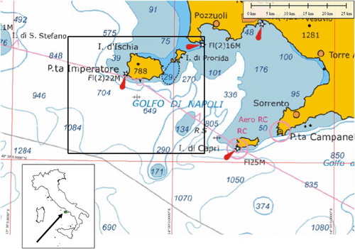
Ischia Island is an active volcanic complex in the NW sector of Naples Bay (). The island represents the emerged section of a wider volcanic ridge, characterized by a complex morphology resulting from the interplay of constructional-monogenetic cones, sedimentary processes, gravitational instability and tectonics.
Figure 1. Location map of the study area.
The first underwater exploration around the island started in 1998 as part of a regional reconnaissance survey aimed at studying gravity instabilities around the selected volcanic islands in the Tyrrhenian Sea (CitationChiocci et al., 1998). The 1998 survey highlighted the instability of the southern slope of the island, and was followed by several marine investigations, carried out over the last 10 years by the IAMC – CNR of Naples (with Gruppo Nazionale per la Vulcanologia), that demonstrated the existence of a diffuse instability around most of the volcanic complex (CitationAiello, Marsella, & Passaro, 2009, Citation2012; Citationde Alteriis et al., 2010; Citationde Alteriis, Tonielli, Passaro, & de Lauro, 2006; Citationde Alteriis & Violante, 2009; CitationBudillon, Violante, & e De Lauro, 2003; CitationChiocci & de Alteriis, 2006; CitationViolante et al., 2003). Similar to the inland setting, the Ischia offshore area is characterized by the occurrence of monogenetic edifices, frequently emplaced by subaqueous explosive eruptions, aligned along a NE-SW system of faults that link the south-eastern sector of Ischia to the island of Procida and to the Campi Flegrei. Furthermore, geophysical surveys carried out in 2000 and 2001 revealed for the first time the importance of a collapsed volcanic complex mostly located to the west of the island (CitationBruno, de Alteriis, & Florio, 2002), in a sector characterized by the presence of a strong residual magnetic anomaly field. The aim of this paper is to present and describe the bathymetry of the seafloor surrounding Ischia, particularly the submerged volcanic bodies in the western and southwestern sector of the volcanic complex
2. Geological setting
Ischia Island (40° 43′N, 13° 53'E) is located on the north-western side of the Naples Bay, along the eastern Tyrrhenian margin characterized by the extension and volcanism during the Pliocene-Quaternary. Together with Campi Flegrei and Procida Islands, the Ischia volcanic complex belongs to the ‘Phlegrean Volcanic District’ (CitationD'Antonio, Tonarini, Arienzo, Civetta, & Di Renzo, 2007) characterized by high alkaline magmas that produced trachytes and phonolites, and smaller amounts of latites and shoshonites.
Ischia volcanic activity, punctuated by hundreds of small to medium scale eruptions, occurred over the past 135 ka (CitationGillot, Chiesa, Pasquarè, & Vezzoli, 1982). During this period, a major ignimbritic eruption occurred at 55 ka with the emplacement of Mount Epomeo Green Tuff (CitationVezzoli, 1988) which was associated with caldera collapse in the central part of the island. The last eruption occurred in 1302 AD, with the emplacement of the Arso alkali-trachyte lava flow in the eastern part of the island.
Mount Epomeo (788 m a.s.l.) is the island's highest summit and is considered to be a block of Mount Epomeo Green Tuff uplifted as a resurgent dome inside the central caldera depression (CitationGillot et al., 1982; CitationOrsi, Gallo, & Zanchi, 1991). Geomorphologic and geologic evidence suggests that uplift of 700–800 m has occurred over the last 30 ka (CitationCinque et al., 1997; CitationMolin, Acocella, & Funiciello, 2003).
Mount Epomeo is bounded by N-S, E-W, NNW and NNE striking fault systems, in addition to the main NE-SW regional trend (CitationAlessio, Esposito, Ferranti, Mastrolorenzo, & Porfido, 1996; CitationAcocella & Funiciello, 1999). The resurgence also induced slope steepening that caused a diffuse gravitational instability, well documented for the last 5 Ka (Citationde Alteriis et al., 2010; de Vita et al., Citation2006).
3. Data and methods
Multibeam (or swath) bathymetry data acquisition was carried out by IAMC-CNR, Naples Geophysical Laboratory from 1997 to 2005, during several surveys and in the context of different research projects, both in the near-shore and offshore sections of Ischia and Procida Islands (Citationde Alteriis et al., 2006) and in Naples Bay (CitationD'Argenio et al., 2004). Some very limited, shallow water areas were surveyed in single beam mode, while land topography was obtained by the Italian Istituto Geografico Militare (IIGM) through interferometric surveys. The entire bathymetric dataset results from the integration of soundings acquired with different multibeam echosounders (MBES) whose main specifications are summarized in .
Table 1. Multibeam equipment used.
The bathymetric acquisition systems were properly interfaced with a differential global positioning system, which ensured sub-metre accuracy for positioning and with inertial motion sensors for pitch, roll, yaw and heading corrections necessary for beam positioning. Sound velocity profiles (SVP) were usually measured 12 h or more frequently, if required by rapidly changing oceanographic/meteoreological conditions. SVP values were normally applied in real-time during surveys or in the processing phase. Multibeam data processing was carried out using Reson-Thales PDS2000 software, following International Hydrographic Organization standards. Processing was chiefly aimed at removal of navigational errors, noise reduction (e.g. de-spiking), removal of poor quality beams, and tidal and sound velocity corrections (e.g. Citationde Alteriis, Passaro, & Tonielli, 2003).
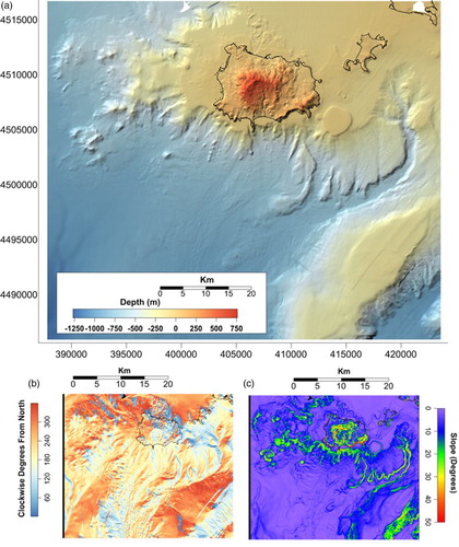
Due to the variable depth range and footprint sizes encountered, a depth-variant horizontal resolution ranging from 1.5 to 20 m characterizes the data. In order to generate a regularly spaced matrix (or Digital Terrain Model (DTM), (a) and Main Map) a 20 × 20 m grid cell was adopted, related to the biggest footprint value. The marine dataset has been further integrated with topographic data acquired by the IGM with the same horizontal resolution (20 m grid cell size), resulting in a marine-terrestrial DTM, covering the −1000 m/ + 787 m elevation range, and extending over an area of ≈1100 km2. Aspect ((b)) and slope ((c)) thematic maps were also calculated, in order to complement the morphological information quantitatively. The range of slope is 0°–65° ((c)).
Figure 2. DTM of Ischia Island. (a) Shaded relief; (b) Aspect map; (c) Slope map.
4. Discussion and conclusions
4.1. General seafloor morphology
As a first step, the large-scale morphologic features have been singled out through the aid of a histogram with elevation versus average slope gradients. Such an approach allows a discrete number of morphological areas characterized by similar elevation/slope pairs to be highlighted; these can be associated to specific morpho-structural settings (CitationPassaro, Ferranti, & de Alteriis, 2011; CitationPassaro et al., 2010). The calculation was carried out by using a 1 m depth window and then calculating the average slope value of all the DTM cells that fall inside each window. The plot was smoothed using a median filter (5 × 5 pixel window).
The study area has been divided into major morphological domains, each one characterized by a well-defined elevation interval vs. average slope ( and ):
Figure 3. Diagram showing the main morphological units of the seafloor surrounding Ischia.
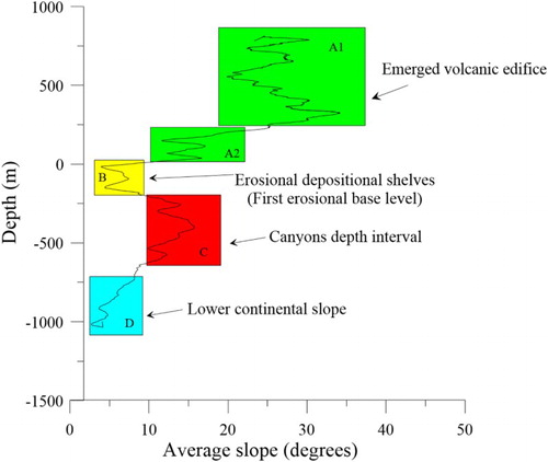
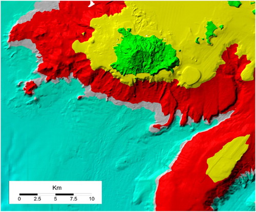
Figure 4. DTM of Ischia Island. Colours represent the main morphological units based on slope/depth pairs. See text for further details.
(A1) The sub-aerial section of the Ischia volcanic edifice corresponding to Mount Epomeo and other high-relief volcanic edifices of the island characterized by slope gradients ranging from 20°–35° on average (, A1);
(A2) An intermediate, low-relief sub-aerial section that joins the area A1 to the shoreline with slope gradients ranging from 10°–15° on average (, A2);
(B) The continental shelf, between the shoreline and the 140–150 m (200 m in some cases) isobaths, roughly coinciding with the shelf-break (slope gradients 3° to 8°, on average) (, A2);
(C) The upper continental slope, located between the shelf- break and the 600 m isobath (slope gradients 8° to 20°, on average) (, C);
(D) The lower continental slope, from the toe of the upper slope at 600 m depth to about 1100 m (slope gradients <8°, on average) (, D).
Each domain includes several, poorly spaced, morphological features that are indicative of local tectonic, sedimentary or volcanic events. We note the increase of dip angles in the lower portion of the A unit, which is probably due to basal faulting of the Mount Epomeo uplifted block ( and ). Drainage patterns are prevailing in the A domain while submarine drainage, depressions and canyons characterize the C domain. These morphologies provide sediment transport pathways towards the mainly depositional B and D domains ((c) and ).
Some major points that arise from the analysis outlined above suggest the importance of volcano-tectonic and erosional, gravity-driven processes. In particular,
the anomalous high gradients in the A1 domain are related to the volcano-tectonic fault scarps responsible for Mount Epomeo block uplift;
in B, the shelf edge is strongly eroded by canyon head-scarps and gullies;
the C domain corresponds to the upper continental slope, but its higher than expected slope gradient suggests that it is tectonically controlled;
the D domain corresponds to the lower continental slope and its average slope gradient is consistent with analogous lower slopes for the Tyrrhenian region.
The morphometric analogies between C and A domains are attributed to fault scarps accompanying the volcano-tectonic uplift, although it is not possible, based on present data, to define the age of sub-aerial and underwater faults and establish a time correlation between them. In turn, the volcano-tectonic activity has probably favoured and controlled the erosional drainage system, that is, channels and canyons, particularly over the southern slope for two main reasons:
in order to create a sedimentary shortcut between the shelf and deeper sectors, and to quickly remove the sediment surplus generated from volcanic eruptions;
through morphologic rejuvenation of the southern slope and continuous re-location of the erosional base-level.
4.2. Toponymy
Shoals, peaks, localities and most of the morphological highs (herafter ‘banks’) were named according to the official terrestrial and marine cartography. Names derived from persons or events that characterize the history of Ischia Island are proposed in the final map for the major previously unknown banks, as listed below:
Pithecusa – Pithecussai was the first Greek settlement established on the island (7th century B.C.). The name comes from mythical inhabitants of volcanic areas in Greek mythology.
Rittmann – Alfred Rittmann (1893–1981) was a Swiss geologist who is considered to be the founder of modern volcanology and the author of a still widely recognized geo-volcanologic synthesis of Ischia Island (CitationRittmann, 1930, Citation1948).
P. Buchner –Paul Buchner (Nuremberg, 1886 – Ischia, 1978) was a German zoologist and cytologist who permanently settled on the island in 1944. He was the founder of the Ischia Island Study Centre.
G. Buchner – Giorgio Buchner (Monaco, 1914 – Ischia, 2005) was a German archaeologist who studied the origins of Ischia Island and the Magna Graecia colonies.
Mazzella – Lucia Mazzella (Ischia, 1947 – Ischia, 1999) was an Italian scientist and team leader of the Benthic Ecology Laboratory of the Stazione Zoologica ‘A. Dohrn’.
M. Posillipo – Motonave Posillipo was the name of the research vessel which dramatically sunk in Naples Bay on 15 December 1988, causing the death of two researchers, Bruno Scotto Di Carlo and Patrizia Mascellaro, and of the skipper, Vincenzo Tramontano.
Software
The cartographic layers were produced using Global Mapper and Surfer. The final map was produced using QGIS.
Bathymetric map of Ischia Island and its offshore (Italy)
Download PDF (62.5 MB)Acknowledgements
We sincerely thank Luigi Ferranti, John Shaw and Matti Peljo for their comments on the draft manuscript that have helped us to improve the early version of the paper. A special thank goes to Mike Smith and Colin Pain for their patient editorial work. This work has been partially supported by the Ritmare Project (Deep Sea Environment) funded by the Italian Ministry of University and Research.
ORCID
Salvatore Passaro http://orcid.org/0000-0002-3045-9002
References
- Acocella, V., & Funiciello, R. (1999). The interaction between regional and local tectonics during resurgent doming: The case of the island of Ischia, Italy. Journal of Volcanology and Geothermal Research, 88, 109–123.
- Aiello, G., Marsella, E., & Passaro, S. (2009). Submarine instability processes on the continental slopes off the campania region (Southern Tyrrhenian Sea, Italy): The case history of Ischia Island (Naples Bay). Bollettino di Geofisica Teorica ed Applicata, 50(2), 193–207.
- Aiello, G., Marsella, E., & Passaro, S. (2012). Stratigraphic and structural setting of the Ischia volcanic complex (Naples Bay, Southern Italy) revealed by submarine seismic reflection data. Rendiconti Lincei, 23(4), 387–408.
- Alessio, G., Esposito, E., Ferranti, L., Mastrolorenzo, G., & Porfido, S. (1996). Correlazione tra sismicità ed elementi strutturali nell'Isola d'Ischia. Il Quaternario, 9(1), 303–308.
- de Alteriis, G., Insinga, D., Morabito, S., Morra, V., Chiocci, F. L., Terrasi, F., … Pazzanese, M. (2010). Age of submarine debris avalanches and tephrostratigraphy offshore Ischia Island, Tyrrhenian Sea, Italy. Marine Geology, 278(1–4), 1–18.
- de Alteriis, G., Passaro, S., & Tonielli, R. (2003). New, high resolution swath bathymetry of gettysburg and ormonde seamounts (gorringe bank, Eastern Atlantic) and first geological results. Marine Geophysical Researches, 24, 223–244.
- de Alteriis, G., Tonielli, R., Passaro, S., & de Lauro, M. (2006). Batimetria multi fascio delle isole flegree 1:30.000, 1 Vol., 76 pp., ISBN: 978-88-207-3901-0 (Liguori ed.).
- de Alteriis, G., & Violante, C. (2009). Catastrophic landslides off Ischia volcanic Island (Italy) during prehistory. Geological Society of London, Special Publication, 322, 73–104.
- Bruno, P. P. G., de Alteriis, G., & Florio, G. (2002). The Western undersea section of the Ischia volcanic complex (Italy, Tyrrhenian Sea) inferred by marine geophysical data. Geophysical Research Letters, 29(9), 57–51.
- Budillon, F., Violante, C., & e De Lauro, M. (2003). I fondali delle isole flegree: Geologia e morfologia. In M. C. Gambi, M. De Lauro, & F. e Iannuzzi (Eds.), Ambiente marino costiero e territorio delle isole flegree (Ischia, Procida e Vivara) e Golfo di Napoli. Risultati di uno studio multidisciplinare (pp. 43–64). Napoli: Monografia Accademia delle Scienze Matematiche, Fisiche e Naturali.
- Chiocci, F. L., & de Alteriis, G. (2006). The Ischia debris avalanche: First clear submarine evidence in the mediterranean of a volcanic Island prehistorical collapse. Terra Nova, 18(3), 202–209.
- Chiocci, F. L., Martorelli, E., Sposato, A., Aiello, G., Baraza, J., Budillon, F., … Tonielli, R. (1998). Prime immagini tobi dei fondali del tirreno centro-meridionale (settore orientale). Geologica Romana, 34, 207–222.
- Cinque, A., Aucelli, P. P. C., Brancaccio, L., Mele, R., Milia, A., Robustelli, G., … Sgambati, D. (1997). Volcanism, tectonics and recent geomorphological change in the Bay of Napoli. Supplementi di Geografia Fisica e Dinamica Quaternaria, 3, 123–141.
- D'Antonio, M., Tonarini, S., Arienzo, I., Civetta, L., & Di Renzo, V. (2007). Components and processes in the magma genesis of the Phlegrean volcanic district, Southern Italy. Special Paper of the Geological Society of America, 418, 203–220.
- D'Argenio, B., Aiello, G., de Alteriis, G., Milia, A., Sacchi, M., Tonielli, R., … Violante, C. (2004). Digital elevation model of the Naples Bay and adjacent areas, eastern Tyrrhenian Sea. In G. Pasquarè & C. Venturini (Eds.), Mapping geology in Italy, APAT (Agenzia per la Protezione dell'Ambiente e per i Servizi Tecnici)–National Geological Survey of Italy (Spec. Vol., pp. 22–28). Florence: S.E.L.C.A.
- Gillot, P. Y., Chiesa, S., Pasquarè, G., & Vezzoli, L. (1982). 33.000 yr K/Ar dating of the volcano-tectonic horst of the isle of Ischia, gulf of Naples. Nature, 229, 242–245.
- Molin, P., Acocella, V., & Funiciello, R. (2003). Structural, seismic and hydrothermal features at the border of an active intermittent resurgent block: Ischia Island (Italy). Journal of Volcanology and Geothermal Research, 121(1–2), 65–81.
- Orsi, G., Gallo, G., & Zanchi, A. (1991). Simple shearing block-resurgence in caldera depressions. A model from pantelleria and Ischia. Journal of Volcanology and Geothermal Research, 47, 1–11.
- Passaro, S., Ferranti, L., & de Alteriis, G. (2011). The use of high resolution elevation histograms for mapping submerged terraces: A test from the eastern Tyrrhenian Sea and the Eastern Atlantic ocean. Quaternary International, 232(1–2), 238–249.
- Passaro, S., Milano, G. D'isanto, C., Ruggieri, S., Tonielli, R., Bruno, P., … Marsella, E. (2010). DTM-Based morphometry of the Palinuro seamount (Italy, Eastern Tyrrhenian Sea): Geomorphological and volcanological implication. Geomorphology, 115(1–2), 129–140.
- Rittmann, A. (1930). Geologie der Insel Ischia. Zeitragefur Vulkanologie Z. Vulkanol, 6, 1–265.
- Rittmann, A. (1948). Origine e differenziazione del magma ischitano. Schweizerische Mineralogische Und Petrographische Mitteilungen, 28, 643–698.
- Vezzoli, L. (1988). Island of Ischia. Quaderni de “La ricerca scientifica” progetto finalizzato “geodinamica”. Monografie finali, 10, 134.
- de Vita, S., Sansivero, F., Orsi, G., & Marotta, E. (2006). Cyclical slope instability and volcanism related to volcano-tectonism in resurgent calderas: The Ischia Island (Italy) case study. Engineering Geology, 86(2–3), 148–165.
- Violante, C., Budillon, F., Esposito, E., Porfido, S., & Vittori, E. (2003, May 14–16). Submerged hummocky topographies and relations with landslides. North-western flank of Ischia Island, Southern Italy. In L. Picarelli (Ed.), Proceedings of “Occurrence and mechanisms of flow-like landslides in natural slopes and earthfills” (pp. 309–315), Sorrento.