
Abstract
Four 1:15,000 maps for the coastal area of Mar Piccolo (Taranto, southern Italy) are presented. The study area is a small, sheltered shallow marine basin of about 20 km2, located north of Taranto town. It contains some submarine, karstic freshwater springs (citri) that have determined the development of intensive aquaculture in the past. Now, the Mar Piccolo is a highly polluted area due to the presence of both military and industrial navy docks and various heavy industries located in proximal areas: (i) the ILVA steel plant in Taranto, the largest in Europe; (ii) the ENI oil refinery and (iii) the CEMENTIR, the largest cement and concrete plant in southern Italy. Many studies show that water and sediments are contaminated (heavy metals, isopropyl alcohol, polychlorinated biphenyl [PCB], etc.), and various remediation projects are now in preparation. In this study, we analyze the physical characteristics of the Mar Piccolo environment by producing several maps: a geological map; a geomorphological map; a bathy-morphological map and a map of the thickness of surficial sediment. All these maps are original products focused on the realization of a reliable geological picture for the Mar Piccolo area. They represent the first steps toward the detailed knowledge of the Mar Piccolo physical environment, which we consider to be a fundamental requirement for developing the most appropriate remediation techniques.
1. Introduction
The Mar Piccolo (literally, ‘Little Sea’) is a small, protected marine basin (surface area ∼20 km2) located north of Taranto town (southern Italy). It is an inner marine basin, presently connected with the open sea (Mar Grande in the Ionian Sea) through two channels, the smaller natural and the bigger artificial. It is morphologically like a figure eight (): a north–south-oriented promontory divides it into two sub-circular bays (Primo in the west and Secondo Seno in the east – ) with some lagoonal features. It is a very shallow marine basin with reduced hydrodynamism (microtidal regime and scarce wave action). It contains some large, circular submarine springs (locally named citri) and represents the base level for small tributary streams that carry moderate amounts of agricultural chemicals.
The Mar Piccolo basin is directly and significantly impacted by intensive mussel aquaculture (CitationCaroppo et al., 2012) and by the presence of fishery facilities, an abandoned shipyard (built at the beginning of the twentieth century) and a very large Italian Navy port (that has been active for 130 years). Furthermore, Taranto is considered one of the most polluted towns in Italy and Western Europe. The pollution is mainly factory-related, being produced by various heavy industries close to the urban areas: (i) the ILVA (former ITALSIDER) steel plant that is the largest in Europe ( and ); (ii) the ENI oil refinery ( and ), which processes the oil produced in the entire Val D'Agri fields and (iii) the CEMENTIR, which is the largest cement and concrete plant in southern Italy. Since 1991, the Italian Ministry of Environment has declared this area as a High Environmental Risk Area. In fact, the Taranto industrial area produces 92% of Italy's dioxin, representing 8.8% of the entire European production, and pollution is comparable to some areas of China and Romania where the highest toxic discharges in the world are recorded (CitationINES-EPER, 2006).
Figure 1. The Mar Piccolo area. Note the presence of massive factories close to both the Mar Piccolo and the town of Taranto.
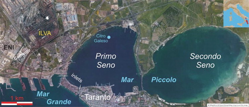
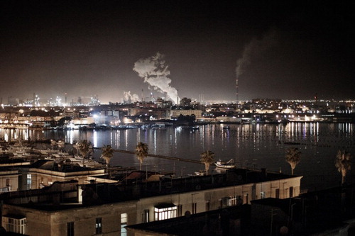
Figure 2. Night view of the Mar Piccolo area. Note the poles for mussel aquaculture in the Mar Piccolo and, in the background, the chimneys, with industrial discharge, of the ILVA steel plant and the ENI oil refinery. Photo courtesy of Mattia Insolera.
Data from epidemiological studies show a dramatic mortality excess (for all causes of death, all cancers, lung cancer, cardiovascular and respiratory diseases, etc.) in the residents around the Taranto industrial district (CitationPirastu et al., 2013). Recent studies carried out on breast milk sampled in nursing women living in the Taranto area show a content of dioxins which is 10–40 times higher than the tolerable intake values established by the World Health Organization (CitationBianco et al., 2013). Water and sediment of the Mar Piccolo area record organic pollution (polychlorinated biphenyls – PCBs, and parent polycyclic aromatic hydrocarbons, CitationCardellicchio et al., 2007) and high heavy metal concentrations (Cd, Cu, Hg, Pb, Sn, Zn, etc., CitationBuccolieri et al., 2006; CitationCalace et al., 2005; CitationDe Marco, Dimuccio, Mastronuzzi, Mazzarella, & Sergio, 2004). Different remediation methods are available for the removal, containment and treatment of contaminated sediment (see CitationReible & Lanczos, 2006; CitationU.S. EPA, 2005 and references therein). Choice of the most appropriate remediation technique must be based on a large number of economic, environmental and social factors: in the Mar Piccolo area, preliminary studies focused on the selection of possible strategies for remediation have been carried out by the Regional Agency for Environmental Protection (ARPA PUGLIA) and financially supported by specific national legislative procedures (D.L. 7/8/2012, n.129, and L. 4/10/2012). In this paper, we present data and maps produced for ARPA PUGLIA during these studies. The main objective of this work is to provide a complete picture of the physical basis of the Mar Piccolo and the surrounding areas. In particular, we present four thematic maps: (1) a geological map; (2) a geomorphological map; (3) a bathy-morphological map showing the morphology of the Mar Piccolo bottom and (4) a map of the thickness of surficial and unconsolidated sediment.
2. Methods and description of maps
In this section, we will briefly present the main methodologies used both to collect data and build each cartographic product. All maps have been produced at the same scale and with the same bounding coordinates. The base topographical map is a Regional Technical Map at a 1:15,000 scale (Sheets 493 and 494) with the UTM-WGS 84 geographic coordinate system.
2.1. The geological map
The geological setting of the Taranto area is relatively simple and well known in the literature. It is located in the south-western sector of the Apulian foreland along the Ionian Sea in southern Italy (). The Apulian foreland is the Pliocene–Pleistocene foreland of the South Apennines orogenic system and corresponds to a wide, buckled lithospheric zone (CitationBiju-Duval, Letouzey, & Montadert, 1978). The Taranto area records the main Quaternary tectonic and sedimentary phases that involve the entire Apulian foreland. Until the late Early Pleistocene, the Apulian foreland underwent a phase of extensive subsidence (CitationCiaranfi, Pieri, & Ricchetti, 1988) induced by active subduction beneath the southern Apenninic Chain (CitationDoglioni, Mongelli, & Pieri, 1994). This subsidence phase (with a rate of about 1 mm/y) is recorded by the Calcarenite di Gravina Formation, which transgressively overlies Mesozoic carbonate rocks, and the argille subappennine unit, which conformably covers the Calcarenite di Gravina Fm. The subsequent uplift phase (with a rate of about 0.1–0.3 mm/y), active at least from the beginning of the Middle Pleistocene (CitationCiaranfi et al., 1988; CitationDoglioni et al., 1994; CitationRicchetti, Ciaranfi, Luperto Sinni, Mongelli, & Pieri, 1988), is recorded by uplifted marine, transitional and fluvial terraces (CitationGallicchio, Moretti, Spalluto, & Angelini, 2014; CitationGioia, Gallicchio, Moretti, & Schiattarella, 2014; CitationTropeano, Sabato, & Pieri, 2002). In particular, in the Taranto area and along the Mar Piccolo cliffs, late Pleistocene deposits crop out with large lateral continuity: for this reason, the last part of the Pleistocene (132,000 to 11,700 years ago, corresponding to about the MIS 5.e) is proposed to be named the Tarantian stage (CitationAmorosi et al., 2014; CitationNegri et al., in press, and references therein), and the Taranto area is suggested as the stratotype. Finally, Holocene and Modern deposits occur in alluvial and marine settings.
The geological map (Main Map 1) of the Mar Piccolo area is mainly based on a critical review of previous cartographic products, notably the Official 1:100,000 Geological Taranto Sheet (CitationMartinis & Robba, 1971), and some maps attached to geological research papers (CitationBelluomini et al., 2002; CitationCotecchia et al., 1989; CitationMastronuzzi & Sansò, 2002; CitationRicchetti, 1967). The present review also took into account the large amount of stratigraphical data coming from: (i) the analysis of more than 150 well logs in continental and marine areas; (ii) detailed outcrop descriptions of six stratigraphical sections and (iii) three geoelectrical surveys and two well cores performed for this work in key areas to resolve some specific stratigraphical correlations. The final map (Main Map 1) was produced at the 1:15,000 scale and includes a sketch cross-section of the geometric relationships between different sedimentary units () and six geological cross-sections that show the actual thickness and geometries of the same sedimentary units in different areas. The map also shows the location of : (i) previous well logs and well logs performed for this project (with different colors); (ii) the main recognized circular continental and submarine artesian springs (citri) and (iii) the main geophysical surveys. The geological map shows reliable interpretations of both the geometric relationships between different sedimentary units and their lateral thickness variations. The locations of the main artesian springs, which are fundamental to the dynamics of the present-day Mar Piccolo basin (), seem to be controlled by both the linear fault and fracture orientation and the presence of relative permeability barriers along the fault zones.
Figure 3. Sketch diagram of the geometric relationships between different sedimentary units in the Mar Piccolo area (not to scale). Note: ALT (Calcare di Altamura Fm., late Cretaceous), GRA (Calcarenite di Gravina Fm., late Pliocene – early Pleistocene), ASP (argille subappennine, late Pliocene – early Pleistocene), MTD (marine-terraced deposits, late Pleistocene), b (continental deposits, late Pleistocene – Holocene), e1 (Mar Piccolo sediments, late Pleistocene – Holocene) and h (anthropogenic deposits).
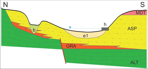
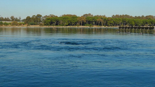
Figure 4. Submerged artesian spring (Citro Galeso) in the Mar Piccolo area. For the location of Citro Galeso, see .
2.2. The geomorphological map
The drafting of the geomorphological map (Main Map 2) of the Mar Piccolo area is based on previous data obtained by means of: (i) field surveys; (ii) orthophoto analysis and (iii) marine terrace dating (CitationAmorosi et al., 2014; CitationAntonioli et al., 2008; CitationBelluomini et al., 2002; CitationCotecchia, Dai Pra, & Magri, 1971; CitationCotecchia et al., 1989; CitationDai Pra & Stearns, 1977; CitationMastronuzzi, 2001; CitationMastronuzzi & Sansò, 2002; CitationRicchetti, 1967). The final geomorphological map (Main Map 2) has been produced at the 1:15,000 scale. It is presented using the symbology proposed as standards for the construction of the Geomorphological National Map (CitationISPRA, 2007). It shows the extent of, and relationships between, the main elements of the present landscape. The main landform is represented by the extended marine terrace connected to the sea-level highstand that occurred during the last interglacial (MIS 5.e), and the Taranto area is well known for the large extent of the marine terrace associated with the deposits of MIS 5.e (CitationAmorosi et al., 2014; CitationNegri et al., in press). The terrace is cut by the inlets of the Mar Piccolo bordered by seasonal beaches and high cliff developed in the Plio–Pleistocene deposits, and also by an ephemeral fluvial network. In the inner part of the Secondo Seno, a delta and related marsh have been built by sediments deposited by the Canale Leverano – D'Aquino, the catchment of which is mainly in Plio–Pleistocene deposits (argille subappennine unit).
Direct scuba surveys have been performed in the vicinity of the citri to investigate their morphology and genesis. They are developed in the Plio–Pleistocene sequence of calcarenites (in the deeper part) and clays, and show a characteristic funnel-like shape. This shape is due to the greater resistance of the calcarenite compared to the softer overlying clays to erosion by the upward-flowing karstic water, which also prevents the accumulation of silty sediments.
2.3. The bathy-morphological map
The bathy-morphological map of the Mar Piccolo area (Main Map 3) has been obtained by means of multibeam (MB) and side-scan sonar (SSS) surveys. Data positioning was obtained through a global positioning system (GPS) receiver (Hemisphere Crescent R100 differential GPS); the navigation software was PDS2000, and was integrated with a gyrocompass and a motion sensor (OCTANS IXEA). The sound speed calibration was obtained by a SeaBird profiler. Data acquisition for multibeam and side-scan sonar profiles was limited by the presence of many different anthropogenic features (series of submerged poles for mussel aquaculture, military areas, rows of buoys with variable orientation, etc.). The bathymetry of the Mar Piccolo has been investigated using a high-resolution multibeam system (RESON Seabat 8125) for the shallowest seafloor areas, obtaining a digital terrain model at 1 m cell size. Side-scan sonar survey was performed using a SSS Klein 3000 with 130–500 kHz frequency, a range of 100 m, 50% overlap between adjacent lines and a resolution of 1 m.
The bathy-morphological map (Main Map 3) shows that the Mar Piccolo basin is characterized by a flat sea bottom, reaching 12 m of water depth (wd), with some restricted negative anomalies, up to 19 m wd, related to the natural water-spring phenomena (citri) or anthropogenic excavation, identifiable both on MB and SSS data. The geomorphology of these depressions shows some peculiarities: in the case of the ‘citri’ the geometry is sub-circular and the boundaries irregular, whereas the excavations present sub-rectangular shapes and vertical flanks. Moreover, traces of mussel aquaculture and anchoring, mostly in front of the Military Navy Area (Primo Seno), can be clearly identified on the seafloor. Sediment mostly comprises sandy mud, which is uniformly distributed and lacks surficial sedimentary structures of natural origin. The integration of MB and SSS enabled us to obtain the highest definition of the natural morphological features of the Mar Piccolo basin, and to identify seafloor landforms.
2.4. Surficial sediment thickness map
The surficial sediment thickness map (Main Map 4) was obtained using the data from a sub-bottom profiler survey using a SBP Innomar 2000 with 10–12–15 kHz frequencies. On the SBP profiles, the first identifiable reflector has been digitized over the whole Mar Piccolo basin. This reflector has been attributed to the last marine transgression and, consequently, the surficial sediment (Main Map 4) represents Holocene transgressive-phase deposition. The thickness of surficial sediment in the Primo Seno ranges from 2 to 3 m, with lower values in areas of excavation. In the north-eastern part of the Primo Seno, a thicker section (4–4.5 m) has been identified, but there are no bathy-morphological data for this area. The Secondo Seno is characterized by two sectors: the northern sector has surficial sediment with a thickness of 2–3 m, whereas the southern one presents a major thickness ranging from 4 to 5 m. The channel between the two bays has the thickest sediment cover, up to 10 m.
3. Conclusions
In the introductory part of this paper, we presented observations about the pollution and health risk for the inhabitants of the Taranto area. In the coming years, major remediation actions will be carried out in this area, and the improvement of the Mar Piccolo basin represents the most complex operation anticipated. Detailed literature data are available for the pollution of sediments, water and faunal assemblages, but key sedimentological and geomorphological data are poorly known, such as the thickness of surficial sediments, the role of the submerged springs (citri) in transporting pollutants and in the processes related to seafloor gravitational instability. Therefore, all the data presented in this paper are focused on characterizing the physical system of the Mar Piccolo basin. Firstly, we analyzed the general geological and geomorphological features of the Taranto area by means of a critical review of the literature and taking into account the database of well logs and other surveys (geophysical or direct field surveys) that was built for this project. More detailed analyses were needed to resolve some unclear aspects; for example, the location of faults concealed beneath overlying younger sedimentary units and the relationships between faults and artesian springs in continental and marine settings were established by means of geoelectric profiles located in key sectors. The nature of some unusual seafloor morphologies and the actual activity of the main submerged artesian springs was evaluated through direct diving surveys. Data on the morphology and sedimentology of the present-day Mar Piccolo basin were collected from multibeam, side-scan sonar and sub-bottom profiler surveys carried out for this project. The four attached maps (Main Maps 1, 2, 3 and 4) represent the state of knowledge of the physical processes acting on the present-day dynamics of the Mar Piccolo basin. These data will be fundamental to the future complex procedures related to the choice of remediation methodologies for one of the most polluted areas of Western Europe.
Software
Analysis of geological, gemorphological and census data was performed using Esri ArcGIS 10. The processing of multibeam, side-scan sonar and sub-bottom profiler data was performed using, respectively, the following applications: PDS2000, Triton Isis and Triton SB Interpreter. All data were integrated and analyzed using ArcGIS 10. Surficial sediment thickness was created using Golden Software Surfer 10.
Geological map of the Mar Piccolo area
Download PDF (47 MB)Acknowledgements
The authors wish to thank Massimo Blonda and Nicola Ungaro for their assistance during every phase of data acquisition. A special thank is due to the photographer Mattia Insolera for the use of one of his artistic shots (see more at http://www.mattiainsolera.net/species/). Finally, we are also immensely grateful to Geraint Owen, Tom van Loon, Heike Apps and Mike J. Smith for their constructive comments on the first version of the manuscript.
Funding
This project was financed by the Regional Agency for the Environmental Protection (ARPA PUGLIA), the Flagship Project RITMARE and the COFIN MIUR 2010–2011 ‘Response of morphoclimatic system dynamics to global changes and related geomorphological hazard’, carried out under the umbrella of the IGCP Project n.588, UNESCO – IUGS.
ORCID
Massimo Moretti http://orcid.org/0000-0003-4920-7128
References
- Amorosi, A., Antonioli, F., Bertini, A., Marabini, S., Mastronuzzi, G., Montagna, P., … Vai, G. B. (2014). The middle-late quaternary Fronte section (Taranto, Italy): An exceptionally preserved marine record of the last interglacial. Global and Planetary Change, 119, 23–38.
- Antonioli, F., Deino, A., Ferranti, L., Keller, J., Marabini, S., Mastronuzzi, G., … Vigliotti, L. (2008). Lo studio della sezione ‘Il Fronte’ per la definizione del piano Tarantiano (Puglia, Italy). Il Quaternario, Italian Journal of Quaternary Sciences, 20(2), 31–34.
- Belluomini, G., Caldara, M., Casini, C., Cerasoli, M., Manfra, L., Mastronuzzi, G., … Vesica, P. L. (2002). Isoleucine epimerization ages & Th/U analyses on raised quaternary marine deposits in the Chéradi Islands and in the Taranto area (Apulia – Southern Italy). Quaternary Science Reviews, 21, 525–547.
- Bianco, G., Zianni, R., Anzillotta, G., Palma, A., Vitacco, V., Scrano, L., & Cataldi, T. R. I. (2013). Dibenzo-p-dioxins and dibenzofurans in human breast milk collected in the area of Taranto (Southern Italy): First case study. Analytical and Bioanalytical Chemistry, 405(7), 2405–2410.
- Biju-Duval, B., Letouzey, J., & Montadert, L. (1978). Structure and evolution of the Mediterranean Basin. In K. J. Hsü & L. Montadert (Eds.), Initial reports of the DSDP (pp. 951–984). Washington: U.S. Govt. Printing Office.
- Buccolieri, A., Buccolieri, G., Cardellicchio, N., Dell'Atti, A., Di Leo, A., & Maci, A. (2006). Heavy metals in marine sediments of Taranto Gulf (Ionian Sea, Southern Italy). Marine Chemistry, 99, 227–235. doi:10.1016/j.marchem.2005.09.009
- Calace, N., Ciardullo, S., Petronio, B., Pietrantonio, M., Abbodanzi, F., Campisi, T., & Cardellicchio, N. (2005). Influence of chemical parameters (heavy metals, organic matter, sulphur and nitrogen) on toxicity of sediments from the Mar Piccolo (Taranto, Ionian Sea, Italy). Microchemical Journal, 79, 243–248.
- Cardellicchio, N., Buccolieri, A., Giandomenico, S., Lopez, L., Pizzulli, F., & Spada, L. (2007). Organic pollutants (PAHs, PCBs) in sediments from the Mar Piccolo in Taranto (Ionian Sea, Southern Italy). Marine Pollution Bulletin, 55(10–12), 451–458.
- Caroppo, C., Giordano, L., Palmieri, N., Bellio, G., Bisci, A. P., Portacci, G., … Hopkins, T. S. (2012). Progress toward sustainable mussel aquaculture in Mar Piccolo, Italy. Ecology and Society, 17(3), 1–19.
- Ciaranfi, N., Pieri, P., & Ricchetti, G. (1988). Note alla carta geologica delle Murge e del Salento (Puglia centromeridionale). Memorie della Società Geologica Italiana, 41, 449–460.
- Cotecchia, V., Dai Pra, G., & Magri, G. (1971). Sul tirreniano della costa ionica salentina (Puglia). Datazione di un campione di coralli con il metodo del Th230/U234. Geologia Applicata e Idrogeologia, 6, 105–112.
- Cotecchia, V., Lollino, G., Pagliarulo, R., Stefanon, A., Tadolini, T., & Trizzino, R. (1989, September 27–30). Studi e controlli in situ per la captazione della sorgente sottomarina Galeso, Mar Piccolo di Taranto. Proceedings of SUOLOSOTTOSUOLO Congresso Internazionale di Geoingegneria, Associazione Mineraria Subalpina, Torino, Vol. 1, pp. 475–484.
- Dai Pra, G., & Stearns, C. E. (1977). Sul tirreniano di Taranto. Datazioni su coralli con il metodo del 230Th/234U. Geologica Romana, 16, 231–242.
- De Marco, A., Dimuccio, L. A., Mastronuzzi, G., Mazzarella, M., & Sergio, A. (2004). Minerali di origine industriale nei sedimenti del litorale di Taranto. Studi Costieri, 8, 121–133.
- Doglioni, C., Mongelli, F., & Pieri, P. (1994). The Puglia uplift (SE Italy): An anomaly in the foreland of the Apenninic subduction due to the buckling of a thick lithosphere. Tectonics, 13(5), 1309–1321.
- Gallicchio, S., Moretti, M., Spalluto, L., & Angelini, S. (2014). Geology of the middle and upper Pleistocene marine and continental terraces of the northern Tavoliere di Puglia plain (Apulia, southern Italy). Journal of Maps, 10(4), 569–575.
- Gioia, D., Gallicchio, S., Moretti, M., & Schiattarella, M. (2014). Landscape response to tectonic and climatic forcing in the foredeep of the southern Apennines, Italy: Insights from Quaternary stratigraphy, quantitative geomorphic analysis, and denudation rate proxies. Earth Surface Processes and Landforms, 39(6), 814–835.
- Ines-Eper. (2006). Register of the National Institute of Emission and their sources integrated by European Pollutant Emission Register. Retrieved April 1, 2008, from http://www.eper.sinanet.apat.it/site/_contentfiles/00000000/50_dati_registro_INES_2006.xls
- ISPRA. (2007). Carta Geomorfologica d'Italia 1:50.000. Guida alla rappresentazione cartografica. Quaderno, III Serie, 4, 177 pp. Firenze: SELCA.
- Martinis, B., & Robba, E. (1971). Note illustrative della Carta Geologica d'Italia, F. 202 ‘Taranto’. Servizio Geologico d'Italia, 56 pp. Cava dei Tirreni, Italy: Arti Grafiche E. Di Mauro.
- Mastronuzzi, G. (2001). Indagine conoscitiva geologico ambientale del sistema del Mar Piccolo (Taranto): caratteri evoluzione, dinamica, valore e pericolosità di un potenziale geosito. Unione Europea, Commissione Europea – DG XVI, Azioni Innovatrici, Programma Terra, Progetto n. 55 Posidonia, Atelier Taranto, Comune di Taranto, VII Settore Governo del Territorio, CD rom, 86 pp.
- Mastronuzzi, G., & Sansò, P. (2002). Pleistocene sea level changes, sapping processes and development of valleys network in Apulia region (southern Italy). Geomorphology, 46, 19–34.
- Negri, A., Amorosi, A., Antonioli, F., Bertini, A., Florindo, F., Lurcock, P. C., … Vai, G. B. (in press). A potential global stratotype section and point (GSSP) for the Tarantian stage, upper Pleistocene: Work in progress. Quaternary International. doi:10.1016/j.quaint.2014.08.057
- Pirastu, R., Comba, P., Iavarone, I., Zona, A., Conti, S., Minelli, G., … Biggeri, A. (2013). Environment and health in contaminated sites: The case of Taranto, Italy. Journal of Environmental and Public Health. Article ID 753719. doi:10.1155/2013/753719
- Reible, D., & Lanczos, T. (2006). Assessment and remediation of contaminated sediments. NATO Science Series, Series IV: Earth and Environmental Sciences, 73, 267 pp. Dordecht: Springer.
- Ricchetti, G. (1967). Osservazioni preliminari sulla geologia e morfologia dei depositi quaternari nei dintorni del Mar Piccolo (Taranto). Atti Accademia Gioenia di Scienze Naturali in Catania, 6/18, 123–130.
- Ricchetti, G., Ciaranfi, N., Luperto Sinni, E., Mongelli, F., & Pieri, P. (1988). Geodinamica ed evoluzione sedimentaria e tettonica dell'Avampaese Apulo. Memorie della Società Geologica Italiana, 41, 57–82.
- Tropeano, M., Sabato, L., & Pieri, P. (2002). Filling and cannibalization of a foredeep: The Bradanic Trough, southern Italy. In S. J. Jones & L. E. Frostick (Eds.), Sediment flux to basins: Causes, controls and consequences. Geological Society (pp. 55–79). London: Spec. Publ., 191.
- U.S. EPA. (2005). Contaminated sediment remediation guidance for hazardous waste sites. EPA Report, EPA-540-R-05–012, 236 pp. Retrieved December 16, 2009, from http://www.epa.gov/superfund/health/conmedia/sediment/pdfs/guidance.pdf