
Abstract
This paper presents a general geomorphological map of the coastal zone of Veracruz State, Mexico, produced using topographic information, digital orthophotos and high-resolution aerial photographs, as well as a study of geological materials and field survey. Hierarchical levels established for the typological classification are (a) relief categories (mountains, hills and plains); (b) relief subcategories (low mountains; foothills; large, medium and small hills; very high, high, medium, low and very low plains); (c) specific morphogenetic relief type, according to morphology, morphometry and the genetic formation process, and geological substratum; (d) relative age of relief, according to correlated data for the Mexican–Caribbean region; and (e) morphogenetic formations complex. The geomorphological history of relief development in the region reveals a period of compression of the palaeo-mesozoic substratum, during the Laramide orogeny, followed by neotectonic reconstruction of the morphostructure, primarily in the mountains, giving rise to intense erosion–denudation processes and the break-up of relief during the Pliocene and up to the present day. These conditions contributed to the spread of a varied, complex and interdigitated sedimentation, shaped by marine, fluvial, lacustrine–palustrine and aeolian processes which, under glacio-eustatic conditions during the Quaternary, established a system of terraced plains of different origin, dissected or not dependent on the prevailing lithology. The study area of 7872 km2 was divided into five sectors: Tamiahua, Poza Rica, Veracruz, Alvarado and Coatzacoalcos, and mapped at a scale of 1:110,000.
1. Introduction
The spectrum of Mexican geomorphological mapping is diverse. Morphogenetic surveys in national cartographic works with coverage of the country's relief are available at scales of 1:1,000,000 and 1:9,400,000 (CitationLugo-Hubp & Córdova Fernández de Arteaga, 1990, Citation2007). Regional type surveys are available at scales of 1:1,000,000 and 1:250,000 for the states of Veracruz, Michoacán, Tabasco and Oaxaca (CitationBocco, Mendoza, & Velázquez, 2001; CitationGeissert, 1999; CitationHernández, Ortiz Pérez, & Figueroa Mah Eng, 2009; CitationOrtiz Pérez, Hernández Santana, Figueroa Mah Eng, & Gama Campillo, 2011). Local type studies have been developed by CitationLugo-Hubp, Mooser, Pérez, and Zamorano (1994), CitationZamorano, Tanarro, Lugo-Hubp, and Sánchez Rubio (2002), CitationHernández Santana, Bollo Manent, Méndez Linares, and Figueroa Mah Eng (2009), CitationHernández Santana, Méndez Linares, and Bollo Manent (Citation2012) and CitationMendoza-Margáin, Zamorano Orozco, Alvarado González, Santos Rojas, and Figueroa García (2012), among others. Some of these works have a morphogenetic character while others focus on territorial planning.
At a local level in Veracruz, the only examples of detailed morphogenetic cartography are of the localities of La Mancha and El Llano, at a scale of 1:50,000, and are for landscape mapping (CitationPriego, 2004).
For this reason, the main objective of the present morphogenetic survey of the coastal relief of the Veracruz state is to contribute to morphological and morphometric knowledge of the existing landforms and to present the genetic, chronological and evolutionary characteristics of relief development in the context of polygenetic landform development.
This landform development reflects the action of endogenic (orogenic, tectonic and volcanic) and exogenic (erosion; denudation; marine abrasion and accumulation; aeolian deflation and accumulation; fluvial, lacustrine and swampy accumulation; and intense anthropogenic modification in recent centuries) processes.
2. Study area
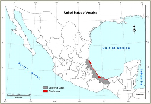
The coastal zone of Veracruz State forms the central Mexican part of the Gulf of Mexico, with a coastline of approximately 750 km and a surface area covered in this geomorphological survey of 7872 km2. This long, narrow territory lies between latitude 17° 15′ and 22° 30′ North and longitude 94° 06′ and 97° 57′ West, and is bordered by Tamaulipas State to the north, the Gulf of Mexico to the east, Tabasco State to the southeast and the inner boundary of the coastal zone to the west ().
Figure 1. Location of study area.
2.1. Geological framework
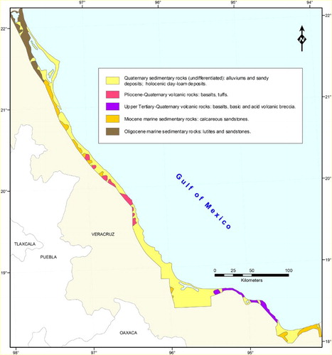
The oldest basement of Veracruz is represented by intrusive, metamorphic and sedimentary rocks of Palaeozoic and Mesozoic age, while the Cenozoic column is composed of intrusive and volcanic complexes (gabbros, basalts, tuffs, andesitic complex and upper Tertiary volcanic breccia), carbonates (Miocene sandstones) and terrigenous components (Oligocene lutites and sandstones; sandstones, conglomerates, alluviums and Quaternary sandy deposits; Holocene clay loam deposits) (CitationINEGI, 1984; CitationOrtega-Gutiérrez, Mitre Salazar, & Roldán Quintana, 1992) ().
Figure 2. Simplified geology of the study area.
The coastal relief was determined by the tectonic and volcanic evolution of the Gulf of Mexico region and by uplift of the Sierra Madre Oriental during the Laramide orogeny (upper Cretaceous to Eocene). Neotectonic movements that were initiated in the Miocene determined the current mountains’ elevation and the developing of the complex coastal morphogenesis. Volcanic activity occurred between the end of the Tertiary and during the Quaternary, while the coastal region differentially rose and fell during the Pliocene and the Quaternary (CitationLugo-Hubp, 1990). There were also changes in sea level during the Quaternary.
Morphostructural and morphogenetic differentiation of relief, as well as the distribution of geomorphic processes generally are determined by the development of the Tampico-Misantla, Veracruz and Salina del Istmo basins. The low mountains, foothills and hills developed in the volcanic and tectonic-volcanic building of Los Tuxtlas and the Massif of Teziutlán. The formation of fluvial, lacustrine-swampy, marine and aeolian-marine plains occurs under a continuous coastal sedimentary process in the depressed geological structures.
2.2. Prevailing geomorphic processes in the coastal area
The criteria adopted for the definition of exogenic geomorphic processes in this survey correspond, in general, to CitationGoudie (2004):
Denudation processes: ‘Denudation includes all processes that remove the relief at the surface of the Earth. Denudation acts chemically or physically’ (CitationGaillardet, 2004).
Terrestrial erosion processes: Commonly speaking, the term erosion is used to indicate the overall group of processes that are directed at levelling off Earth relief. Erosion includes acquiring materials from the higher elevations and moving them from one place to another (CitationLupia-Palmieri, 2004). Running water and wind are the main agents of erosion in the study area. Running water can operate as surface wash affecting soil and regolith materials, while channelled flow incises the landscape to form valleys.
Marine erosion: This is mechanical destruction ‘produced by the long-continued wave erosion (CitationBates & Jackson, 1987)’. In the study area, the authors identified isolated fragments of raised marine terraces, formed during the Pleistocene and Holocene by marine erosional processes.
Depositional processes: These processes lead to deposits of rocks, minerals and organic waste on the terrestrial surface or in basins, and may include fluvial, lacustrine and marine processes (CitationLugo-Hubp, 2011).
Fluvial depositional process: These modify the terrestrial surface along river valleys by depositing alluvium in floodplains, alluvial plains and terraces (see CitationGregory, 2004).
Lacustrine and swamp process: These operate in areas with depressed relief, forming very low depositional plains that are permanently or periodically flooded.
Aeolian depositional process: This is the transport and deposition of material by the wind, forming different types of dunes, ripple marks and other forms (CitationWiggs & Livingstone, 2004).
Marine depositional processes: These are generated by the waves, tides and long shore currents, creating beaches, sand spits, bars and other coastal landforms.
These geomorphic processes are incorporated into the legend of the geomorphic map, as set out in Section 3.
3. Materials and methods
For the morphogenetic relief classification, digital orthophotographs (CitationINEGI 2000, Citation2001, Citation2002) with complete coverage of the study area were interpreted at a scale of 1:20,000, together with 29 topographic map sheets at a scale of 1:50,000. Geological sources included a geological map, at a scale of 1:250,000 (CitationINEGI, 1984), a geological-mining monograph of Veracruz State (CitationConsejo de Recursos Minerales, 1994) and a geological map of the Mexican Republic (CitationOrtega-Gutiérrez et al., 1992).
The following methods were used to compile the geomorphological map of the coastal area:
Stereoscopic interpretation of aerial photographs at a scale of 1:75,000, to delimit areas of different genetic types, identifying and mapping the complex of genetic landforms from the digital orthophotographs, and selecting locations of interest for a more detailed field study;
The construction of a digital elevation model, from 1:50,000 digital base data for the analysis of the structural orientation of the relief, the genetic identification of landforms and automated morphometric interpretation;
Mapping of marine terraces, highlighting their elevation and relative chronologies;
Fieldwork aimed at analysing coastal deposits, the stratigraphic relationships of the various units, the structural characteristics of layered materials and verification of the morphogenetic boundaries;
Creation of the morphogenetic map, taking into account genesis, morphology, morphometrics and relative chronology, the latter derived from a correlation scheme of regional dating of the Gulf of Mexico (CitationHernández Santana, Méndez Linares, & Figueroa Mah Eng, 2007).
On the basis of morphogenetic relief classification (CitationPortela Peraza, Díaz Díaz, Hernández-Santana, Magaz García, & Blanco Segundo, 1989), and of the general geomorphological particularities of the coast of Veracruz, the authors propose the following hierarchical levels of typological classification:
Categories of relief (low mountains, foothills, hills and plains systems), determined by differences in the intensity of the neotectonic movements;
Altitude ranges of the relief (in m): low mountains, with altitudes between 500 and 800 m; foothills between 200 and 400 m; large- and medium-sized hills, between 200 and 300 m; small hills up to 80 m; very high and high plains, between 60 and 100 m; medium-high between 40 and 60 m; low and very low, under 20 m;
Specific morphogenetic types of relief, according to morphology, morphometry and genetic formation processes, and including indications concerning geological substratum and relative age;
Genetic complex of relief forms (tectonic, marine, erosional, denudational, fluvial, aeolian and anthropogenic, among others), via aerial, linear and point symbols, according to international convention.
All geomorphological information was processed using Esri ArcGIS v9.3. The final geomorphological map was presented for five sectors (Map 1): Tamiahua (Sector A), Poza Rica (Sector B), Veracruz (Sector C), Alvarado (Sector D) and Coatzacoalcos (Sector E) at a scale of 1:110,000, adjusted to A0 format of the Journal of Maps.
4. Results
The following types of landforms are recognised in the study area.
4.1. Low mountains and foothills
Low mountains formed on Quaternary basalt flows are moderately dissected, and range 600–800 m in elevation. Others formed on Upper Tertiary intermediate tuffaceous and andesitic volcanic rocks are dissected, are more isolated and range 500–700 m in elevation. There are also some dissected foothills with flat and stepped interfluves of erosional origin, formed on Upper Tertiary and Quaternary andesitic and basaltic flows, ranging 200–400 m in elevation. All are confined to Sector C, Veracruz.
4.2. Hills
Hills are formed on a variety of rock types including Tertiary basalt, tuffaceous and andesitic volcanics, gabbros, lutites, acid and basic volcanic breccia, and Quaternary conglomerates and sandstones. Large and medium hills range from 200 to 300 m in elevation, medium hills from 100 to 200 m in elevation and low hills are generally below 100 m. Some are dissected and have remnants of erosion surfaces, including summit surfaces. Some occur as isolated conical hills, and some are monoclinal in nature. Hills are found in all five sectors.
4.3. Marine plains
Marine plains range in elevation from 10 to 200 m. However, their elevations do not readily fall into groups, so it is not possible to define any regional sea levels from them.
Low and very low marine plains, formed on Quaternary coastal sand spit systems, are less than 10–15 m in elevation. Slightly undulating to flat marine plains are formed on middle Tertiary calcareous sandstones, basalts, andesites, acid tuffs and basic volcanic breccia, and are less than 20 m in elevation.
Medium to low, hilly to undulating marine plains formed on Miocene calcareous sandstones and Tertiary basalt complex occur at 20–40 m in elevation. Some of these have remnant erosion surfaces. Medium, undulating to hilly marine plains, occasionally sloping, with remnants of erosion surfaces, are formed on Miocene calcareous sandstones, basalts and tertiary acid tuffs, at 40–60 m in elevation. Some of these have chains of parabolic and transversal dunes of N–S orientation, especially on Quaternary coastal sandy deposits.
At higher levels, marine plains on volcanic lava flows and basalt complexes occur at more than 140 m in elevation. There are also very hilly, dissected marine plains, with remnants of erosion surfaces, formed on Upper Tertiary basic volcanic basalts and tuffs, at 60–120 m in elevation. Some of the higher ones are sloping.
Finally, undulating and flat marine plains with chains of parabolic and transverse dunes of N–S orientation, with an elevation of 120–200 m, are formed on Quaternary coastal sandy deposits. Marine plains occur in all five sectors.
4.4. Fluvial plains
Low and very low fluvial plains are flat to undulating, with undifferentiated floodplains and terrace levels, formed on Middle Tertiary and mainly Quaternary conglomerates and alluvium, < 10 m in elevation. There are also higher and dissected fluvial plains that are undulating to hilly, in some places formed on Oligocene associations of sandstones, lutites and conglomerates and in others on basalts, basic tuffs and associations of Quaternary sandstones, lutites and conglomerates. These plains are between 20 and 60 m in elevation. Fluvial plains occur in all five sectors.
4.5. Coastal lakes and swampy plains
Very low, flat coastal lakes and swampy plains with biogenic microrelief are formed on non-consolidated fine Holocene sediments at less than 2 m in elevation. They are tidal in nature, and occur in all sectors.
5. Conclusions
The morphogenesis of the coastal relief of Veracruz is closely related to (a) the geotectonic evolution of the passive continental margin of the Gulf of Mexico, which provides the morphostructural setting of peripheral mountain systems and coastal basins (structures from the Laramide orogeny, neotectonic deformations and Miocene–Quaternary volcanism); (b) the influence of the humid-tropical hydrothermal system on the development of exogenic geomorphological processes, and the intensity and extent of coastal sedimentation; (c) marine modelling and flattening, controlled by glacio-eustatic Quaternary sea level oscillations; and (d) the position relative to the Northeast trade winds, in the formation of younger aeolian relief.
The geomorphological mapping of this coastal zone provides a new cartographic product, which supplies detailed information on the geomorphology of the area. This map has great value to specialists of natural ecosystems, environmental management and land planning. In addition, it supports the learning needs of modern geographical and geomorphological teaching in Mexico.
Software
In manipulating and processing data, as well as map production, Esri ArcGIS v9.3 was used.
Coastal geomorphological cartography of Veracruz State, Mexico. Sector A. Tamiahua
Download PDF (7.9 MB)Acknowledgements
The authors would like to thank the National Council for Science and Technology (Consejo Nacional de Ciencia y Tecnología, CONACYT) and the Ministry of the Environment and Natural Resources (Secretaría de Medio Ambiente y Recursos Naturales, SEMARNAT) for their financing under call number 2002-CO1–0126. In addition, they acknowledge the support of José Manuel Figueroa Mah Eng in the technical process. We also thank Ailsa Winton for English translation and the anonymous reviewers for their valuable suggestions. Special thanks to Colin Pain for his reviews and academic recommendations.
Additional information
Funding
Related Research Data
References
- Bates, R. L., & Jackson, J. A. (1987). Glossary of geology (3rd ed., p. 788). Alexandria, VA: American Geological Institute.
- Bocco, G., Mendoza, M., & Velázquez, A. (2001). Remote sensing and GIS-based regional geomorphological mapping – a tool for land use planning in developing countries. Geomorphology, 39, 211–219. doi: 10.1016/S0169-555X(01)00027-7
- Consejo De Recursos Minerales. (1994). Monografía geológico-minera del Estado de Veracruz (p. 123). México, D. F.: Pedagógica Iberoamericana.
- Gaillardet, J. (2004). Denudation. In A. S. Goudie (Ed.), Encyclopedia of geomorphology (pp. 240–244). London: Routledge.
- Geissert, D. (1999). Regionalización geomorfológica del estado de Veracruz, Investigaciones Geográficas, Boletín del Instituto de Geografía. UNAM, 40, 23–47.
- Goudie, A. S. (2004). Encyclopedia of geomorphology (p. 1202). London: Routledge.
- Gregory, K. J. (2004). Fluvial Geomorphology. In A. S. Goudie (Ed.), Encyclopedia of geomorphology (pp. 392–398). London: Routledge.
- Hernández Santana, J. R., Bollo Manent, M., Méndez Linares, A. P., & Figueroa Mah Eng, J. M. (2009). Formación y morfogénesis del extremo noroccidental del estado de Chiapas, México, Investigaciones Geográficas, Boletín del Instituto de Geografía. UNAM, 68, 25–40.
- Hernández Santana, J. R., Méndez Linares, A. P., & Bollo Manent, M. (2012). Análisis morfoestructural del extremo noroccidental del estado de Chiapas, México. Revista Geográfica Venezolana, 53(1), 57–75.
- Hernández Santana, J. R., Méndez Linares, A. P., & Figueroa Mah Eng, J. M. (2007). Caracterización del relieve plio-cuaternario del entorno costero del Estado de Veracruz, México. Cuaternario y Geomorfología, 21(3–4), 113–131.
- Hernández Santana, J. R., Ortiz Pérez, M. A., & Figueroa Mah Eng, J. M. (2009). Análisis morfoestructural del estado de Oaxaca, México: un enfoque de clasificación tipológica del relieve, Investigaciones Geográficas, Boletín del Instituto de Geografía. UNAM, 68, 7–24.
- INEGI. (1984). Mapa geológico, a escala 1:250,000, México, DF.
- INEGI. (2000). Ortofotos digitales, a escala 1:20,000, México, DF.
- INEGI. (2001). Ortofotos digitales, a escala 1:20,000, México, DF.
- INEGI. (2002). Ortofotos digitales, a escala 1:20,000, México, DF.
- Lugo-Hubp, J. (1990). El Relieve de la República Mexicana. Revista del Instituto de Geología, 9, 82–111.
- Lugo-Hubp, J. (2011). Diccionario geomorfológico. México DF: Universidad Nacional Autónoma de México. pp. 479.
- Lugo-Hubp, J., & Córdova Fernández de Arteaga, C. (1990). Geomorfología 1, En Atlas Nacional de México. México DF: Instituto de Geografía, UNAM.
- Lugo-Hubp, J., & Córdova Fernández de Arteaga, C. (2007). Geomorfología, En Nuevo Atlas Nacional de México. México DF: Instituto de Geografía, UNAM.
- Lugo-Hubp, J., Mooser, F., Pérez, A., & Zamorano, J. J. (1994). Geomorfología de la Sierra de Santa Catarina, D. F., México. Revista Mexicana de Ciencias Geológicas, 11(1), 43–52.
- Lupia-Palmieri, E. (2004). Erosion. In A. S. Goudie (Ed.), Encyclopedia of Geomorphology (pp. 331–336). London: Routledge.
- Mendoza-Margáin, C., Zamorano Orozco, J. J., Alvarado González, R., Santos Rojas, M., & Figueroa García, J. E. (2012). Cartografía geomorfológica y evolución del relieve del complejo volcánico Tacana, México-Guatemala, VIII Reunión Nacional de Geomorfología. Guadalajara, 8, 105–107.
- Ortega-Gutiérrez, F., Mitre Salazar, L. M., & Roldán Quintana, J. (1992). Carta geológica de la República Mexicana escala 1:2,000,000. México DF: Instituto de Geología, UNAM.
- Ortiz Pérez, M. A., Hernández Santana, J. R., Figueroa Mah Eng, J. M., & Gama Campillo, L. (2011). Tasas de avance transgresivo y regresivo en el frente deltaico tabasqueño: en el período comprendido del año 1995 al 2008 (303–411). In A.V. En Botello, S. Villanueva-Fragoso, J. y. Gutiérrez, & J. L. Rojas Galaviz (Eds.) Vulnerabilidad de las zonas costeras mexicanas ante el cambio climático (2nd ed., p. 754). Campeche: Epomex-Universidad Autónoma de Campeche.
- Portela Peraza, A. H., Díaz Díaz, J. L., Hernández-Santana, J. R., Magaz García, A. R., & Blanco Segundo, P. (1989). Geomorfología, En Nuevo Atlas Nacional de Cuba. Madrid: Instituto Geográfico Nacional de España.
- Priego Santander, A. G. (2004). Relación entre la heterogeneidad geoecológica y la biodiversidad de ecosistemas costeros tropicales (Tesis doctoral). Instituto de Ecología, A. C., Xalapa, 117 pp.
- Wiggs & Livingstone (2004). Aeolian processes. In A. S. Goudie (Ed.), Encyclopedia of geomorphology (pp. 8–11). London: Routledge.
- Zamorano, J. J., Tanarro, L. M., Lugo-Hubp, J., & Sánchez Rubio, G. (2002). Evolución geológica y geomorfológica de la Sierra de los Pitos, norte de la cuenca de México. Revista de Ciencias Geológicas, 19(1), 66–69.